| Προγραμματιστής: | David King (6) | ||
| Τιμή: | Δωρεάν | ||
| Κατατάξεις: | 0 | ||
| Κριτικές: | 0 Γράψτε μια κριτική | ||
| Λίστες: | 0 + 0 | ||
| Βαθμοί: | 2 + 4 (3.3) ¡ | ||
| App Store | |||
Περιγραφή
")
- Super fast start up each time, picks up where you left off.
- Single screen with Heads Up Display(HUD) for realtime operation.
- Auto Zoom toggles anytime.
- Six step navigation lets you advance one step at time forward with the "GO" button and the same for the "BACK" button.
GET STARTED
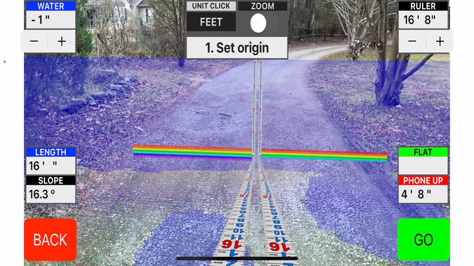
Step 1 - Set origin: Aim the red pointer for the target and tap "GO". Remember you are placing a measuring stick here, not a micrometer. If you are not satisfied, tap "BACK". It is real easy to do over.
Step 1 - Neutral: The measuring stick is now fixed but will still rotate to face you. This is a good time to adjust the "WATER" level ,if needed, with the stepper in the upper left-hand corner of the view. Notice how the water "puddles" so you can see low spots that might not be noticed. When you go up with the water level it advances one inch at a time. Notice how it "fills" the scene and wraps around irregular shapes with ease for easy marking. You can either watch your own hand in the scene, or you can guide an assistant to the right position.
Step 2 - Set length: Two more measuring sticks are now active. Stretch it to right place and tap "GO". You have a dashboard gauge in the upper right-hand corner for the "Ruler". This is the actual distance between the two points. In the bottom left-hand corner there is "LENGTH" which is the horizontal distance between the two points. Below it is the "SLOPE" which gives the angle in degrees between the two points. 0.6 degrees is 1/8 inch per foot. 1.2 degrees is 1/4 inch per foot. The bottom most gauge on the right is the "LEVEL". This is the vertical distance between the two points.
Step 2 - Neutral: Everything is frozen for closer inspection and evaluation.
Step 3 - Set Width: The width can be stretched in either direction off the baseline. The "SLOPE" gauge transforms to "WIDTH".
Step 3 - Neutral: Adjust the "HEIGHT" , if needed, with stepper in the upper right-hand corner. It increments one inch at a time. The box stays on top of the water. The two gauges in the bottom right corner are for "AREA"(represented in square feet or square meters), and the "VOLUME" one uses cubic yards, or cubic meters.
A LiDAR-equipped device is recommended.
Στιγμιότυπα οθόνης


Τιμή
- Σήμερα: Δωρεάν
- Ελάχιστο: Δωρεάν
- Μέγιστο: $19.99
Παρακολούθηση τιμών
Προγραμματιστής
- David King
- Πλατφόρμες: iOS Εφαρμογές (6)
- Λίστες: 0 + 0
- Βαθμοί: 4 + 21 ¡
- Κατατάξεις: 0
- Κριτικές: 0
- Εκπτώσεις: 0
- Βίντεο: 0
- RSS: Εγγραφή
Βαθμοί
-

- 5,730 Pui Hang Choi
- +1
-
- 5,736 sf
- +1


Κατατάξεις
Δεν βρέθηκε ☹️
Λίστες
Δεν βρέθηκε ☹️
Κριτικές
Γίνε ο πρώτος που θα αξιολογήσει 🌟
Πρόσθετες πληροφορίες
- Εκδοχή: 1.3
- ID: com.learnframing.BigFoot
- Κατηγορία:
iOS Εφαρμογές›Βοηθητικά προγράμματα - Λειτουργικό σύστημα:
iPad,iPhone,iOS 16.3 και νεότερες εκδόσεις - Μέγεθος:
10 Mb - Υποστηριζόμενη γλώσσα:
English - Αξιολόγηση περιεχομένου:
4+ - App Store Εκτίμηση:
3.3(4) - Ενημερώθηκε:
- Ημερομηνία έκδοσης:
Μπορεί επίσης να σας αρέσει
-
- Level - Check The Level
- iOS Εφαρμογές: Βοηθητικά προγράμματα Με: Level Software Inc.
- Δωρεάν
- Λίστες: 0 + 0 Κατατάξεις: 0 Κριτικές: 0
- Βαθμοί: 0 + 1 (5.0) Εκδοχή: 9.0.0 Elevate your contracting business with the Check the Level app! Specializing in job costing and bookkeeping, this app is designed for residential contractors aiming to efficiently ... ⥯
-
- Precision Plex - Wireless
- iOS Εφαρμογές: Βοηθητικά προγράμματα Με: Precision Circuits, Inc.
- Δωρεάν
- Λίστες: 0 + 0 Κατατάξεις: 0 Κριτικές: 0
- Βαθμοί: 0 + 7 (3.3) Εκδοχή: 5.06.01 Precision Plex - Wireless allows control of your RV electronics using your phone or tablet. If your RV is equipped with the Precision Plex system and Wireless Module module, this app ... ⥯
-
- Transit Tracking ELD
- iOS Εφαρμογές: Βοηθητικά προγράμματα Με: Transit Tracking LLC
- Δωρεάν
- Λίστες: 0 + 0 Κατατάξεις: 0 Κριτικές: 0
- Βαθμοί: 0 + 8 (2.5) Εκδοχή: 1.9.1 With Transit Tracking ELD you can: 1. Keep more accurate and cost-effective logbooks Reduce drivers time spent on updating logbooks and eliminate the costs of paper forms and the time ... ⥯
-
- Precision OT Transceiver Tool
- iOS Εφαρμογές: Βοηθητικά προγράμματα Με: Precision Optical Transceivers
- Δωρεάν
- Λίστες: 0 + 0 Κατατάξεις: 0 Κριτικές: 0
- Βαθμοί: 0 + 2 (5.0) Εκδοχή: 6.1.0 Allows tuning of an optical Transceiver using the Precision Optical Transceivers bluetooth tuning box, the TN100-S-BT ⥯
-
- Level Tool - Angle Finder App
- iOS Εφαρμογές: Βοηθητικά προγράμματα Με: Andrei Nemtsou
- Δωρεάν
- Λίστες: 0 + 0 Κατατάξεις: 0 Κριτικές: 0
- Βαθμοί: 0 + 33 (4.1) Εκδοχή: 1.3.8 Level Tool app is designed to provide you with accurate readings of any surface by utilizing your device's built-in gyroscope and accelerometer. With Level Tool, you no longer need to ... ⥯
-
- Mini Cashier
- iOS Εφαρμογές: Βοηθητικά προγράμματα Με: Halo Innovation Technology Co., Ltd.
- * Δωρεάν
- Λίστες: 0 + 0 Κατατάξεις: 0 Κριτικές: 0
- Βαθμοί: 0 + 0 Εκδοχή: 2.0.1 Mini cashier is a simple yet powerful cashier app designed for small businesses and individual vendors. It enables you to easily manage products, view daily sales records, and provides ⥯
-
- Level my RV
- iOS Εφαρμογές: Βοηθητικά προγράμματα Με: iker Pryszo
- Δωρεάν
- Λίστες: 0 + 0 Κατατάξεις: 0 Κριτικές: 0
- Βαθμοί: 0 + 63 (4.6) Εκδοχή: 2.0 Level my RV will help you level your Travel Trailer, Fifth Wheel, or Motorhome. If you just have one iPhone or iPad, you can use it as a simple level. However, if you have a second ... ⥯
-
- Level Headed: Line Tool
- iOS Εφαρμογές: Βοηθητικά προγράμματα Με: Dark Noise LLC
- $1.99
- Λίστες: 0 + 0 Κατατάξεις: 0 Κριτικές: 0
- Βαθμοί: 0 + 0 Εκδοχή: 1.1 Level Headed is the best app for making sure you're head is... level! It's hard when taking screenshots on Apple Vision Pro to make sure your shots are perfectly even. Level Headed ... ⥯
-
- Mini Counter
- iOS Εφαρμογές: Βοηθητικά προγράμματα Με: Daniel Arden
- Δωρεάν
- Λίστες: 0 + 0 Κατατάξεις: 0 Κριτικές: 0
- Βαθμοί: 0 + 9 (3.8) Εκδοχή: 1.5 Introducing Mini Counter, the ultimate counter for your Apple Watch! Effortlessly track and manage counts for any activity, whether it's tallying apples or keeping score in a board ... ⥯
-
- Precision Tracking
- iOS Εφαρμογές: Βοηθητικά προγράμματα Με: SPEEDOTRACK GPS (OPC) PRIVATE LIMITED
- Δωρεάν
- Λίστες: 0 + 0 Κατατάξεις: 0 Κριτικές: 0
- Βαθμοί: 0 + 0 Εκδοχή: 1.0 Simple | Effective | Easy to Use Precision Tracking Vehicle Tracking Solutions combine sophisticated GPS tracking technology with flexible, advanced mapping and reporting software. A ... ⥯
-
- Mini HKI
- iOS Εφαρμογές: Βοηθητικά προγράμματα Με: Expert Electronics Comercio e Fabricacao de Produtos Eletronicos Ltda
- Δωρεάν
- Λίστες: 0 + 0 Κατατάξεις: 0 Κριτικές: 0
- Βαθμοί: 0 + 15 (3.1) Εκδοχή: 3.0 Application for managing the MINI HKI processor via bluetooth. MINI HKI processors have everything you need to optimize and protect your sound system. - Channel Routing - General gain ... ⥯
-
- MINI DASH - Display Control
- iOS Εφαρμογές: Βοηθητικά προγράμματα Με: Linus Kemper
- Δωρεάν
- Λίστες: 0 + 0 Κατατάξεις: 0 Κριτικές: 0
- Βαθμοί: 0 + 0 Εκδοχή: 1.0.2 Take full control of your MINI DASH! Connect via Bluetooth and fine-tune your MINI DASH. Features: Adjust Brightness Perfect visibility day & night Switch Screens Swap between two ... ⥯
-
- Precision Dosing
- iOS Εφαρμογές: Βοηθητικά προγράμματα Με: 华 李
- Δωρεάν
- Λίστες: 0 + 0 Κατατάξεις: 0 Κριτικές: 0
- Βαθμοί: 0 + 1 (5.0) Εκδοχή: 1.1 This app can control the precision dosing.Set the corresponding value to make the equipment automatically add nutrients. It greatly reduces the difficulty of feeding ⥯
-
- Level with voice
- iOS Εφαρμογές: Βοηθητικά προγράμματα Με: Jia Hua Huang
- Δωρεάν
- Λίστες: 0 + 0 Κατατάξεις: 0 Κριτικές: 0
- Βαθμοί: 0 + 3 (5.0) Εκδοχή: 1.6 When measuring the angle, you will have a voice prompt for three ranges: close, very close, or perfect. The voice prompt allows you to keep your eyes away from the screen. Displays the ⥯