| مطوّر البرامج: | SuperMap Software Co., Ltd (6) | ||
| السعر: | مجاني | ||
| لتصنيفات: | 0 | ||
| المراجعات: | 0 أكتب مراجعة | ||
| قوائم: | 0 + 0 | ||
| النقاط: | 0 + 1 (2.0) ¡ | ||
| App Store | |||
الوصف
")
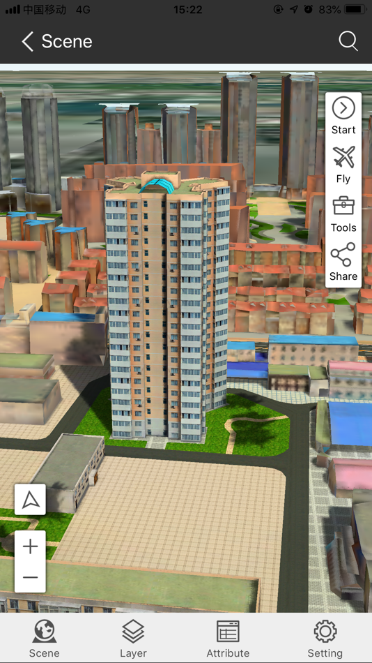
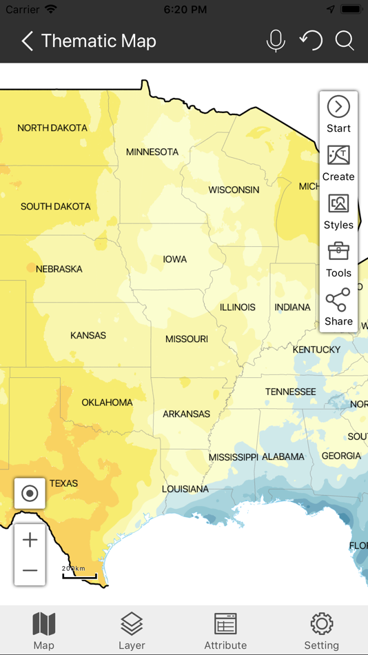
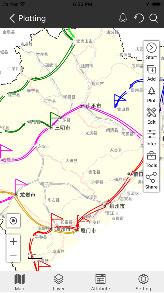
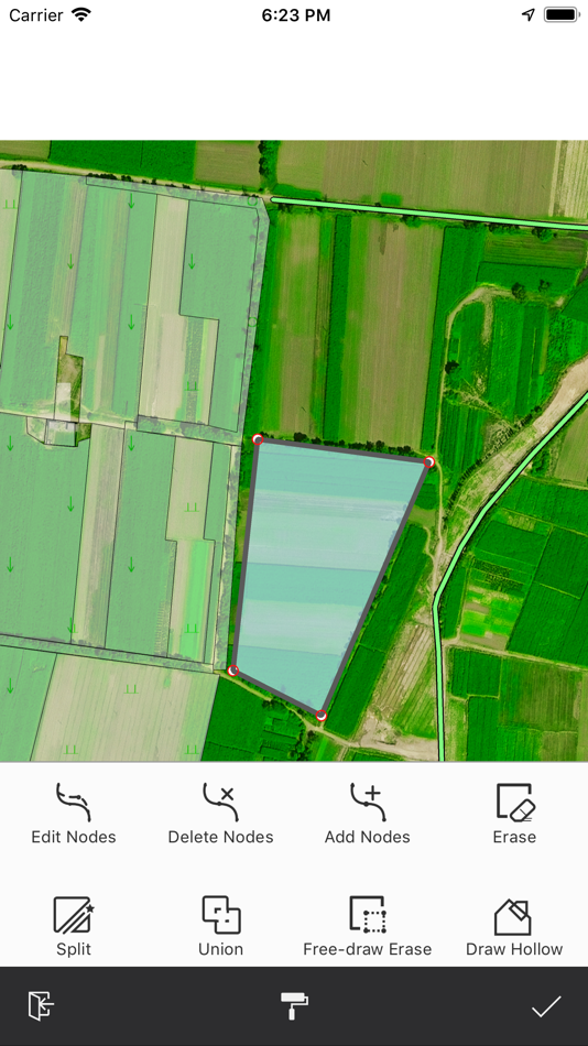
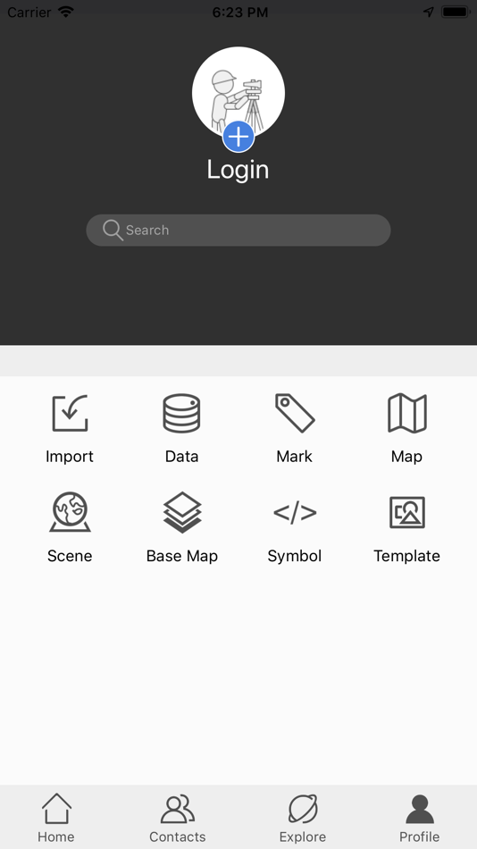
SuperMap iTablet allows you to make maps with your fingers. It serves more than 20 kinds of thematic maps like area maps, stairs maps, rose maps, etc. You can customize color schemes, ranges, and legends for your maps. Apart from these abilities, iTablet supports switching between a marked map and an investigation map. You can switch the display of your map from a vertical orientation to horizontal orientation and vice versa. AR Map module has the ability to integrate videos and GIS, fuse maps and real-word scenes, and project kinds of spatial data like vector data, models, images, terrain, special effects, POI, websites, and so on. Moreover, the module can not only recognize, detect, and classify targets, but also measure areas, distances, and heights. The data processing module supports a series of data analyses (like buffer zone analysis, overlay analysis, network analysis, etc.), four registration algorithms, and 6 projection transformation methods. Also, it allows you to copy and reset the coordinate system of data. The navigation collection module allows you to collect data by drawing manually or recording traces. The field collection provides multiple collection templates and supports collecting data by picking up points with satellites, hands, and gestures. Furthermore, you can edit objects like merging or splitting them. The plotting module supports drawing and importing diverse symbols like military symbols, multiple arrows, and infrastructure symbols. The scene view module supports various 3D data including fine models, oblique photography models, BIM, and terrain. You can perform a flythrough after enabling a flying route with the module.
Apart from all modules we mentioned above, SuperMap iTablet has the capacity of cooperation of cloud sides and mobile sides, managing your account, data resources, friends, feedback, and all sharing. In the meanwhile, you are allowed to access public resources provided by SuperMap Online and browse SuperMap technical communication forum.
SuperMap iTablet supports custom interfaces. Such as you can customize its title, icon, and home page. At the same time, you are allowed to develop and load plugins as needed.
لقطات


السعر
- اليوم: مجاني
- الحد الأدنى: مجاني
- الحد الأقصى: مجاني
تتبّع الأسعار
مطوّر البرامج
- SuperMap Software Co., Ltd
- المنصات: iOS تطبيقات (6)
- قوائم: 0 + 0
- النقاط: 0 + 2 ¡
- لتصنيفات: 0
- المراجعات: 0
- تخفيضات: 0
- أشرطة فيديو: 0
- RSS: اشتراك
النقاط
0 ☹️
لتصنيفات
0 ☹️
قوائم
0 ☹️
المراجعات
كن الأول لمراجعة هذا المنتج 🌟
معلومات إضافية
- الإصدار: 11.1.1
- الفئة:
iOS تطبيقات›الأدوات المساعدة - نظام التشغيل:
iPad,iPhone,iOS 11.0 والأحدث - الحجم:
264 Mb - اللغة المعتمدة:
Chinese,English - تقييم المحتوى:
4+ - App Store تقييم:
2.0(1) - تم التحديث:
- تاريخ الإصدار:
- 🌟 مشاركة
- App Store
قد يعجبك ايضا
-
- Super Translate
- iOS تطبيقات: الأدوات المساعدة بواسطة: Super Tools Technology Co., Limited
- مجاني
- قوائم: 0 + 0 لتصنيفات: 0 المراجعات: 0
- النقاط: 0 + 0 الإصدار: 1.1.1 Super Translate is the leading translation and dictionary application. Easily translate text or start voice conversion, supporting multiple languages. With the new model, you can use ... ⥯
-
- Super VPN Proxy - SuperVPN
- iOS تطبيقات: الأدوات المساعدة بواسطة: Super Free VPN AI Master Lab
- مجاني
- قوائم: 0 + 1 لتصنيفات: 0 المراجعات: 0
- النقاط: 1 + 62 (4.3) الإصدار: 2.7 Super VPN will use VpnService to create a network proxy server to provide basic functional services. Super VPN is Free VPN Proxy, and VPN Master. Super VPN is your personal cyber ... ⥯
-
- Super Liquor Conference 2023
- iOS تطبيقات: الأدوات المساعدة بواسطة: Super Liquor Holdings LTD
- مجاني
- قوائم: 0 + 0 لتصنيفات: 0 المراجعات: 0
- النقاط: 0 + 0 الإصدار: 1.0.0 Super Liquor Conference 2023 app is your point of access for information regarding this year's conference in Fiji. You will receive updates to events at the conference, know what ... ⥯
-
- Super B - Be in charge
- iOS تطبيقات: الأدوات المساعدة بواسطة: Super B
- مجاني
- قوائم: 0 + 0 لتصنيفات: 0 المراجعات: 0
- النقاط: 0 + 0 الإصدار: 3.1.6 Use the Be in charge app for your Super B Epsilon battery. Keep track of the voltage, current and state of charge. Be in charge. Super B. ⥯
-
- Super Rod Super Cam
- iOS تطبيقات: الأدوات المساعدة بواسطة: SUPER ROD LIMITED
- مجاني
- قوائم: 0 + 0 لتصنيفات: 0 المراجعات: 0
- النقاط: 0 + 0 الإصدار: 1.19 Through the APP, you can monitor the video, take pictures and video playback, view the photos, and control the LED lights on, off and brightness changes. And take photos and videos are ⥯
-
- Super NFC- Reader & Write
- iOS تطبيقات: الأدوات المساعدة بواسطة: FREE LINK PTE. LTD.
- مجاني
- قوائم: 0 + 0 لتصنيفات: 0 المراجعات: 0
- النقاط: 0 + 6 (3.2) الإصدار: 1.0.0 Super NFC is a powerful NFC tag tool designed to provide you with a seamless NFC tag experience. Harness the power of NFC technology to accomplish tasks with a simple tap, from ... ⥯
-
- Map Marker:Pin, Track&Discover
- iOS تطبيقات: الأدوات المساعدة بواسطة: 海瑞 彭
- * مجاني
- قوائم: 0 + 0 لتصنيفات: 0 المراجعات: 0
- النقاط: 0 + 8 (4.3) الإصدار: 2.1.1 Map Marker App: The Essential Tool for Sales Follow-up and Client Management This Map Marker app combines location tracking, tag categorization, route tracking, and multi-user ... ⥯
-
- Map Measurement Tool
- iOS تطبيقات: الأدوات المساعدة بواسطة: David Gross
- مجاني
- قوائم: 0 + 0 لتصنيفات: 0 المراجعات: 0
- النقاط: 3 + 6 (2.5) الإصدار: 1.8.1 Measure the size of a home lot, plat of land, crop circle, park, sports field, walking route, etc. Apple Maps™ are used. A careful measurement's error is about 1% to 3% for area and ... ⥯
-
- Super Smart Cleaner
- iOS تطبيقات: الأدوات المساعدة بواسطة: VIBE WITH ME LTD
- مجاني
- قوائم: 0 + 0 لتصنيفات: 0 المراجعات: 0
- النقاط: 0 + 637 (4.9) الإصدار: 1.0.4 Welcome to Super Smart Cleaner - Are you exhausted from dealing with incessant lags, storage alerts, and a disorganized gallery on your phone? Embrace a seamless transformation with ... ⥯
-
- Super Cleaner:Cleanup Storage
- iOS تطبيقات: الأدوات المساعدة بواسطة: 宏城 吴
- مجاني
- قوائم: 0 + 0 لتصنيفات: 0 المراجعات: 0
- النقاط: 0 + 308 (4.2) الإصدار: 2.5.8 Download Super Cleaner to deeply clean up your phone Tidy up similar or duplicate photos and redundant videos on your phone in seconds, and give your device a fresh new look . Fast, ... ⥯
-
- Super Translate - Voice Text
- iOS تطبيقات: الأدوات المساعدة بواسطة: Doubsmart Technology Co., Ltd.
- مجاني
- قوائم: 0 + 0 لتصنيفات: 0 المراجعات: 0
- النقاط: 1 + 0 الإصدار: 2.0.2 In life, we often encounter many moments that we do not understand, especially travel studies, menus of exotic restaurants, imported goods in supermarkets, foreign mails and foreign ... ⥯
-
- Super Metronome
- iOS تطبيقات: الأدوات المساعدة بواسطة: Philip Braham
- مجاني
- قوائم: 0 + 0 لتصنيفات: 0 المراجعات: 0
- النقاط: 0 + 0 الإصدار: 3.2 A metronome with super powers! Set up any period from 0.2 seconds to many hours or set up beats per minute; set up different sounds and even different sounds for each bar. Say the ... ⥯
-
- Super Widget - Home Widgets
- iOS تطبيقات: الأدوات المساعدة بواسطة: 香兰 张
- * مجاني
- قوائم: 0 + 0 لتصنيفات: 0 المراجعات: 0
- النقاط: 0 + 0 الإصدار: 1.0.4 主要功能 在手机桌面上添加下一个节假日的小组件 你可以定制桌面小组件的颜色样式。 支持平板电脑和暗黑模式 Key Features: Seamless Integration: With its sleek widget design, Countdown Holiday integrates flawlessly with your iPhone's home ... ⥯
-
- Super Maine Coon Stickers
- iOS تطبيقات: الأدوات المساعدة بواسطة: Paul Scott
- $0.99
- قوائم: 0 + 0 لتصنيفات: 0 المراجعات: 0
- النقاط: 0 + 1 (5.0) الإصدار: 1.0 Set of super Maine Coon Cat stickers for your iMessage conversations. ⥯