| 開發人員: | Garmin DCI (5) | ||
| 價錢: | 免費 | ||
| 排名: | 0 | ||
| 評測: | 0 寫評論 | ||
| 清單: | 0 + 0 | ||
| 點數: | 2 + 3,891 (4.7) ¡ | ||
| App Store | |||
描述
")
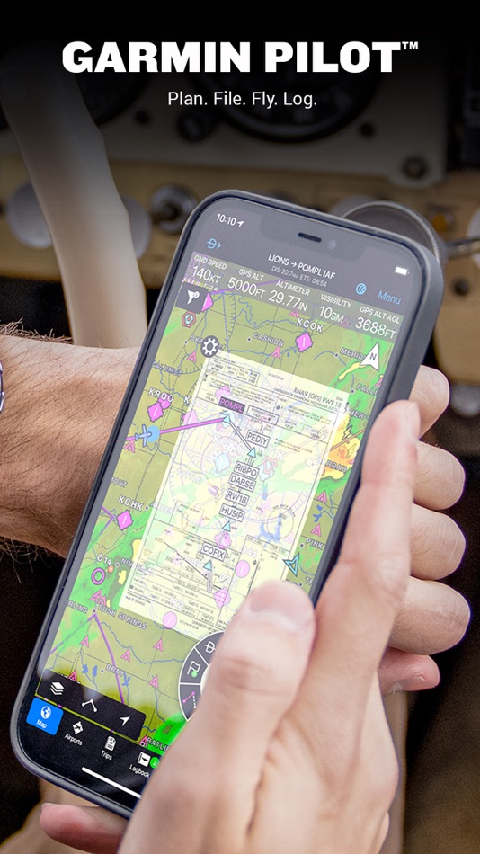
Plan. File. Fly. Log.
Garmin Pilot is the most comprehensive suite of tools for the iPad designed specifically for general aviation and corporate pilots. Flight planning, charts, interactive maps, weather briefing resources and navigation capabilities; it’s all included. The app’s intuitive interface mirrors those on the newest Garmin touchscreen avionics so you can go seamlessly from preflight to inflight.
Plan
Garmin Pilot’s powerful capabilities start with pre-flight planning, providing pilots with the most comprehensive aviation weather information to make better-informed flight decisions. Pilots can check NEXRAD radar, visible and infrared cloud imagery, METARs, TAFs, AIRMETs, SIGMETs, PIREPs, NOTAMs, winds and temperature aloft, TFRs and lightning data. With Garmin Pilot, data can be displayed over Garmin’s interactive maps that support track-up navigation, VFR sectional or an IFR low or high en-route chart to visualize the weather for your route. Add text-based weather widgets and use the exclusive NavTrack feature to view weather along the planned route.
File
With Garmin Pilot, users can easily enter a flight plan and interactively edit it on the map. Pre-loaded forms make it quick to save and reuse data for frequently flown routes. And when the flight plan is ready, Garmin Pilot makes it simple to file, amend or close the flight plan via Leidos Flight Service or DUATS.
Fly
Garmin Pilot provides full en-route navigation capability on its moving map. Pilots can also navigate with Garmin’s patented panel, a GPS-driven instrument pack with a graphical HSI directional display and indicators for groundspeed, altitude and vertical speed. After takeoff, pilots can continue to view real-time weather in the U.S. and traffic information by wirelessly connecting to Garmin’s GDL 50 series portable ADS-B Receiver (sold separately).
Log
Garmin Pilot includes a comprehensive electronic logbook that syncs with flyGarmin. The logbook automatically generates entries based upon GPS data collected during the flight, tracks currency, supports manual entries, endorsements and creates reports.
Garmin Pilot U.S. Standard:
- Rich, interactive maps support Track-Up navigation
- Charts: VFR Sectionals, low and high IFR en-route, airport diagrams and approach procedures
- Ability to view Jeppesen Terminal Charts (Jeppesen echart subscription required)
- Weather Maps: Animated radar, Infrared and Visible Satellite, AIRMETs, SIGMETs, Lightning, TFRs and more!
- Extensive text products: METARs, TAFs, Winds Aloft, PIREPs, AIRMETs, SIGMETs, Area Forecasts and NOTAMs
- AOPA Airport Directory
- Weight and Balance
- Checklists
- Flight plan filing via Leidos Flight Services
- Garmin patented navigation panel
- Terrain and Obstacles
- Smart Airspace
- Fast Find predictive Waypoint Entry
- Logbook
- Optional VFR Premium: Synthetic Vision (SVX), Terrain and obstacle alerting, and Garmin SafeTaxi®
- Optional IFR Premium: VFR Premium plus geo-referenced Garmin FliteCharts®
Garmin Pilot has regional offerings for Africa, Asia, Australia, Canada, Europe and Latin America. Features include:
- Worldwide Jeppesen NavData
- Rich, interactive maps support Track-Up navigation
- Radar and Satellite imagery for Western Europe, U.S., Canada and Australia
- Ability to view Jeppesen Terminal Charts (Jeppesen echart subscription required)
- Worldwide METARs, TAFs, AIRMETs, SIGMETs, NOTAMs and winds aloft
- VFR Flight Plan Filing
- IFR autorouting and Flight plan filing in Europe
- Terrain and Obstacles with alerting
- Synthetic Vision (SVX)
- Smart Airspace
- Logbook
- Optional VFR charts from DFS, IGN and NATS and IFR enroute charts from EuroControl
- Optional Garmin FliteCharts® and SafeTaxi® diagrams available on a country-by-country basis
*Note: Use of GPS running in the background may decrease battery life.*
*Note: One subscription to Garmin Pilot may be used on three devices.*
螢幕擷取畫面


價錢
- 今天: 免費
- 最小值: 免費
- 最大值: 免費
追蹤票價
開發人員
- Garmin DCI
- 平台: iOS 應用程式 (5)
- 清單: 0 + 0
- 點數: 2 + 3,957 ¡
- 排名: 0
- 評測: 0
- 折扣: 0
- 影片: 0
- RSS: 訂閱
點數
-

- 11,911 Lance Eliakim Sotto
- +1
-
- 2,112 Luciole
- +1


排名
0 ☹️
清單
0 ☹️
評測
成為第一個評論 🌟
其他資訊
你可能還喜歡
-
- RunwayMap - #1 Pilot Community
- iOS 應用程式: 天氣 由: RedDev GmbH
- * 免費
- 清單: 0 + 0 排名: 0 評測: 0
- 點數: 0 + 29 (4.3) 版本: 3.9.8 The interactive map gives you an overview of the airports. We have collected important information on every airport: Aviation Weather Forecasts 3D Approach View and 3D Airport ... ⥯
-
- iFlightPlanner
- iOS 應用程式: 天氣 由: iFlightPlanner, LLC
- * 免費
- 清單: 0 + 0 排名: 0 評測: 0
- 點數: 1 + 87 (4.6) 版本: 4.6.000 Welcome to iFlightPlanner for iPad v4.5! iFlightPlanner provides unparalleled flight planning from any computer or mobile device for pilots of all levels flying in the United States ... ⥯
-
- WindAlert: Wind & Weather Map
- iOS 應用程式: 天氣 由: WeatherFlow
- 免費
- 清單: 0 + 0 排名: 0 評測: 0
- 點數: 2 + 3,765 (4.7) 版本: 6.31 WindAlert gives you the weather in your neighborhood, from observations onsite or right next door, get the most accurate wind speed and wind direction. With over 65,000 proprietary ... ⥯
-
- Aviator Assistant: Weather EFB
- iOS 應用程式: 天氣 由: Aviator Assistant LLC
- 免費
- 清單: 1 + 1 排名: 0 評測: 0
- 點數: 2 + 69 (4.5) 版本: 3.55.1 Welcome to Aviator Assistant, your ultimate co-pilot for a safer and more efficient flying experience. Plan, brief, and file your flights with ease, using our advanced tools, briefing ... ⥯
-
- Aviation Weather Route Planner
- iOS 應用程式: 天氣 由: Flygo-Aviation Ltd
- 免費
- 清單: 0 + 0 排名: 0 評測: 0
- 點數: 1 + 228 (4.2) 版本: 6.0 Get full aviation weather, route briefing and airport data in one place! Aviation Weather Route Planner is an all-in-one flight weather and route planner app for pilots with METAR, TAF ⥯
-
- Aviation Weather – METAR TAF
- iOS 應用程式: 天氣 由: Free-Flight-Aviation Ltd.
- * 免費
- 清單: 0 + 0 排名: 0 評測: 0
- 點數: 2 + 1,889 (4.5) 版本: 6.38 Get real-time aviation weather on your iPhone and iPad. Aviation Weather METAR TAF gives pilots instant access to METAR, TAF, NOTAM and airport data worldwide. Quick and reliable for ... ⥯
-
- Dronecast - Weather for Drones
- iOS 應用程式: 天氣 由: Pinverse LTD
- 免費
- 清單: 0 + 0 排名: 0 評測: 0
- 點數: 1 + 156 (4.8) 版本: 2.1.424 Your ultimate drone pilot companion: Get real-time weather forecasts, wind and gust speeds at various altitudes, KP index, customisable drone limits, no-fly zone maps, and a wind ... ⥯
-
- AURA - Smart Weather for Drone
- iOS 應用程式: 天氣 由: Daniel Widjaja
- 免費
- 清單: 0 + 0 排名: 0 評測: 0
- 點數: 0 + 146 (4.6) 版本: 1.2 AURA is a SMART & STUNNING weather forecast app, specially made for DRONE & UAV flights. It s super easy for BEGINNERS, and so powerful for ADVANCED pilot. Hour-by-hour & day-by-day ... ⥯