| Desarrollador: | Pasi Salenius (4) | ||
| Precio: | * Gratis | ||
| Clasificaciones: | 0 | ||
| Opiniones: | 0 Escribir una opinión | ||
| Listas: | 0 + 0 | ||
| Puntos: | 0 + 6 (5.0) ¡ | ||
| Mac App Store | |||
Descripción
")
The app comes preconfigured with a large selection of built-in maps in topographic, nautical, and aerial imagery styles. Save places as map markers that sync between your devices over iCloud. It is easy and fun to measure distances and draw paths on the map, or use Look Around to see street level imagery at any address.
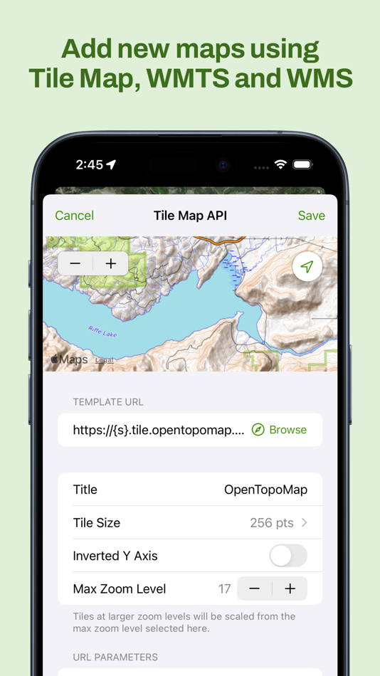
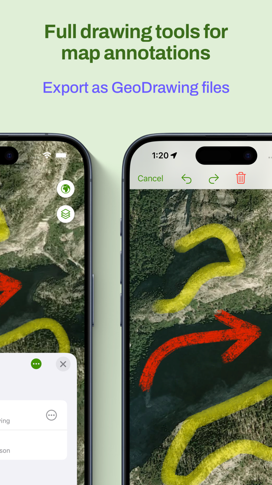
Maptrails Pro one-time purchase unlocks a professional grade feature set. Add your own maps and data layers from standard APIs, and bring in GeoJSON, GPX, IMG, KML or Shapefile data. You can even draw notes directly on the map using touch or pencil!
Maptrails makes it easy to plan your upcoming hike by letting you download map tiles for offline use, view up-to-date weather forecasts, or draw tracks on the map and save them to GPX files. During your hike, record the route to a GPX track or workout in Health app, and graph out its speed and altitude data.
For hunters, integration with Oma Riista lets you import hunting areas using area code. Share your current GPS location with a private group of other Maptrails users.
Build your own dog tracker by installing separate Beacon app to another device and pairing it with Maptrails. Its position can then be tracked on the map in Maptrails.
Maptrails Pro one-time purchase unlocks full functionality
• Use folders to organize tracks and markers
• Attach images to markers from photo library
• Track other devices with Beacon app installed
• Import hunting areas from Oma Riista service
• Get weather forecast for targeted location
• Draw notes on map using touch or pencil
• Import tile maps from web using browser
• Download map areas for offline use
• Share your GPS location with groups
• Draw tracks on map and save as GPX files
• Import GPX files and view them on map
• View workout routes from Health app
• Record workouts and export to GPX
• Add Tile Map, WMTS and WMS maps
• Add GeoJSON, GPX, IMG, KML and Shapefile map layers
• Get new features in future versions
If some map available via open data APIs is not yet included, or you want to make your maps available in Maptrails, please email me at feedback@freshbits.fi. Also follow on Instagram at @KartastoApp.
This app has been built by one developer as a hobby project during many evenings and weekends. Please be nice and take this into account when giving feedback.
Icon symbol credit to Wolf Böse (Creative Commons).
Capturas...


Novedades
- Versión: 2025.7
- Actualizado:
- • Adds support for Garmin IMG layers. This allows viewing data such as hunting areas offline. Find hunting area IMG files at eraluvat.fi. Shows all points, lines and areas included in the IMG file.
• Fixes issues when showing info of areas by tapping them.
• Fixes issues when zooming when tapping on map areas.
• Changes default value of compass true north setting.
• Updates all dependencies.
Precio
-
* Compras en la aplicación - Hoy: Gratis
- Mínimo: Gratis
- Máximo: Gratis
Realizar un seguimiento de los precios
Desarrollador
- Pasi Salenius
- Plataformas: iOS Aplicaciones (2) macOS Aplicaciones (2)
- Listas: 0 + 2
- Puntos: 4 + 24 ¡
- Clasificaciones: 0
- Opiniones: 0
- Descuentos: 0
- Vídeos: 0
- RSS: Suscribirse
Puntos
0 ☹️
Clasificaciones
0 ☹️
Listas
0 ☹️
Opiniones
Sé el primero en escribir una reseña 🌟
Información adicional
- Versión: 2025.7
- Categoría:
macOS Aplicaciones›Navegación - Sistemas operativos:
Apple Watch,iPad,iPhone,macOS,macOS 15.0 y versiones posteriores - Tamaño:
28 Mb - Idiomas admitidos:
Dutch,English,Finnish,French,German,Hungarian,Italian,Norwegian,Polish,Spanish,Swedish - Clasificación de contenido:
4+ - Mac App Store Puntuación:
5.0(6) - Actualizado:
- Fecha de lanzamiento:
Contactos
- 🌟 Compartir
- Mac App Store
También te puede interesar
-
- AMap Global
- macOS Aplicaciones: Navegación De: AutoNavi Information Technology Co. Ltd.
- Gratis
- Listas: 0 + 0 Clasificaciones: 0 Opiniones: 0
- Puntos: 1 + 58,558 (4.7) Versión: 16.5.1 China's first English map for overseas users has officially launched! The Choice of 800 Million Navigation Users. Over 200 countries and territories mapped and hundreds of millions of ... ⥯
-
- GPS Tracks
- macOS Aplicaciones: Navegación De: David Morneault
- * Gratis
- Listas: 6 + 1 Clasificaciones: 0 Opiniones: 0
- Puntos: 10 + 16,416 (4.7) Versión: 5.0.1 "One of the better GPS apps for sporting enthusiasts for the iPhone..." - Bryan Wolfe, AppAdvice.com Do you want to track your hiking, biking, walking, running? Do you want to track ... ⥯
-
- Guru Maps - Offline Navigation
- macOS Aplicaciones: Navegación De: Evgen Bodunov
- Gratis
- Listas: 2 + 0 Clasificaciones: 0 Opiniones: 0
- Puntos: 1 + 2,307 (4.7) Versión: 5.9.3 Detailed and easy-to-use offline maps. We have millions of points of interest (POI) on our maps. Record your GPS tracks and bookmark your favorite locations. OFFLINE MAPS Explore every ⥯
-
- Topo GPS - Topographic maps
- macOS Aplicaciones: Navegación De: rdzl
- Gratis
- Listas: 0 + 0 Clasificaciones: 0 Opiniones: 0
- Puntos: 2 + 409 (4.5) Versión: 10.6.0 Makes from your iPhone, iPad, Apple Watch and/or Macbook a complete GPS device with detailed topographic maps. Viewed maps will be stored on your device so that Topo GPS can also be ... ⥯
-
- Crime and Place: Stats & Map
- macOS Aplicaciones: Navegación De: AMGCI, LLC
- Gratis
- Listas: 0 + 1 Clasificaciones: 0 Opiniones: 0
- Puntos: 1 + 209 (3.9) Versión: 8.3 Stay aware, stay safe with Crime and Place - the crime analysis app that combines data from the FBI and powerful features to keep you safe. The app uses maps and a Crime Compass that ... ⥯
-
- OzRunways EFB
- macOS Aplicaciones: Navegación De: OzRunways Pty. Ltd.
- * Gratis
- Listas: 0 + 0 Clasificaciones: 0 Opiniones: 0
- Puntos: 0 + 143 (4.8) Versión: 13.3.4 OzRunways - Australia's #1 Electronic Flight Bag (EFB) is now available internationally. APPROVED BY Australian CASA under CASR 175. (See https://support.ozrunways.com/kb for ... ⥯
-
- Traffic Time - Fast ETAs
- macOS Aplicaciones: Navegación De: Scott St George
- Gratis
- Listas: 0 + 0 Clasificaciones: 0 Opiniones: 0
- Puntos: 0 + 104 (4.6) Versión: 5.0 Traffic Time makes it easy to view and share exactly how long it will take to reach all of your favorite destinations. Key Features: - iMessage app allows you to quickly add your ETA ... ⥯
-
- Bus Times - This is the Place
- macOS Aplicaciones: Navegación De: Guojie Zeng
- Gratis
- Listas: 0 + 0 Clasificaciones: 0 Opiniones: 0
- Puntos: 0 + 58 (4.8) Versión: 2025.25 Where to go, where to eat want an app that gives you the answer? This Is The Place! The map s starting point is fixed. You can freely zoom and move the map, and always return to the ... ⥯
-
- KWINDOO Tracking for sailing
- macOS Aplicaciones: Navegación De: Kwindoo Magyarorszag Korlatolt Felelossegu Tarsasag
- Gratis
- Listas: 0 + 0 Clasificaciones: 0 Opiniones: 0
- Puntos: 0 + 52 (4.6) Versión: 3.28 Track your sailing with KWINDOO Tracking, or join organized regatta events worldwide. Use Self tracking for your sailing. Track your sailed route, take photos or videos on your boat ... ⥯
-
- GPX viewer - map
- macOS Aplicaciones: Navegación De: Lucas den Otter
- Gratis
- Listas: 0 + 0 Clasificaciones: 0 Opiniones: 0
- Puntos: 0 + 49 (4.5) Versión: 2.0 Introducing GPX Viewer - Route on Map! Are you an outdoor enthusiast who loves hiking, cycling, or exploring new routes? Look no further! GPX Viewer is your ultimate companion for ... ⥯
-
- Arrival BART
- macOS Aplicaciones: Navegación De: Ronan Furuta
- Gratis
- Listas: 0 + 0 Clasificaciones: 0 Opiniones: 0
- Puntos: 0 + 21 (4.7) Versión: 2.1.0 Arrival is the beautiful and clean BART app for commuters. With an interface that is easy and intuitive to use, you get access to real-time train predictions for the station nearest to ⥯
-
- 3D Mappa - GIS & Topo Analysis
- macOS Aplicaciones: Navegación De: Andres Narvaez
- Gratis
- Listas: 0 + 0 Clasificaciones: 0 Opiniones: 0
- Puntos: 0 + 11 (5.0) Versión: 1.5.0 3D Mappa revolutionizes GIS on mobile. Our app puts powerful terrain analysis tools in the palm of your hand, making complex tasks effortless. Instantly visualize elevation, slope, ... ⥯
-
- Topo Fire
- macOS Aplicaciones: Navegación De: Glacier Peak Studios LLC
- Gratis
- Listas: 0 + 0 Clasificaciones: 0 Opiniones: 0
- Puntos: 0 + 10 (4.6) Versión: 2.0 Topo Fire is packed with the maps & tools every Wildland Firefighter needs. FREE Incident Response Pocket Guide (IRPG) Easily accessible right on your phone. Change font size. Change ... ⥯
-
- Fast Fisk
- macOS Aplicaciones: Navegación De: Roger Hjartholm
- Gratis
- Listas: 1 + 0 Clasificaciones: 0 Opiniones: 0
- Puntos: 10 + 0 Versión: 1.0 Track your fishing gear and report catch Easy to use throw out, and reel in Complete tracking database with iCloud support Track Crab, Lobster teine, net, hook and Line Track Boat ... ⥯