| Utvikler: | Replicade Ltd. (2) | ||
| Pris: | Gratis | ||
| Rangeringer: | 0 | ||
| Anmeldelser: | 0 Skrive en omtale | ||
| Lister: | 0 + 0 | ||
| Poeng: | 0 + 2 (2.0) ¡ | ||
| Mac App Store | |||
Beskrivelse
")
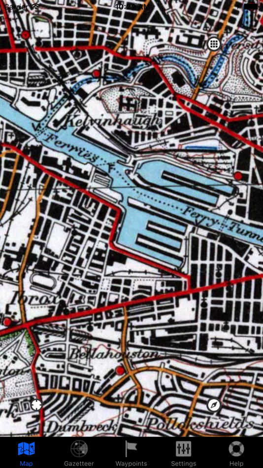
Outside Maps is an iPhone/iPad/iPod Touch application that enables you to view and navigate a wide variety of mapping data using an easy-to-use touch interface.
Outside Maps supports Ordnance Survey mapping for Great Britain at various scales including 1:50000.
Outside Maps supports WORLDWIDE coverage for OpenStreetMap, OpenCycleMap and the Stamen and Thunderforest map sources.
Outside Maps supports historic 1" Ordnance Survey mapping from 1880-1990 and 1921-1947 courtesy of the National Library of Scotland.
Outside Maps supports shaded terrain data for the UK only derived from Ordnance Survey OS Terrain 50. Outside Maps supports shaded terrain data for Scotland only derived from Scottish Government 1m LIDAR.
Outside Maps includes ESRI aerial photography courtesy of ESRI.
Outside Maps includes the following features:
- Intuitive "slippy maps" interface
- Native iPad support in both portrait and landscape modes
- Current Ordnance Survey mapping is available
- OpenStreetMap and derived data is supported at all available resolutions
- Historic 1" Ordnance Survey data from 1880-1990 and 1921-1947
- OpenCycleMap support
- Thunderforest "Landscape" and "Transport" mapping support
- Stamen mapping support
- ESRI aerial imagery
- Hill-shading mapping for the UK at 50m and selected 1m resolution
- Full Ordnance Survey OSTN02 adjustments for highest accuracy (+/- 1m accuracy)
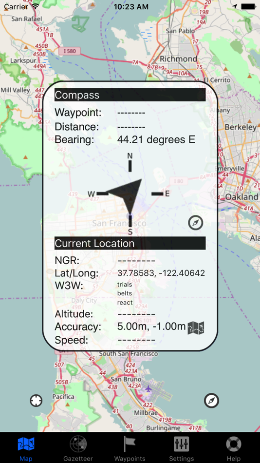
- Real-time position tracking via GPS (or WiFi-based positioning)
- Compass and bearing (either using GPS and movement tracking or hardware compass if available)
- "Lookahead" feature when moving at > 5mph
- Waypoints functionality including import and export via GPX format
- OS OpenSpace-driven postcode and placename lookup (online only)
- Grid reference and latitude/longitude lookup (offline)
- what3words support (online only)
Skjermbilder

Pris
- I dag: Gratis
- Minimum: Gratis
- Maksimalt: Gratis
Spor priser
Utvikler
- Replicade Ltd.
- Plattformer: iOS Apper (1) macOS Apper (1)
- Lister: 0 + 0
- Poeng: 0 + 2 ¡
- Rangeringer: 0
- Anmeldelser: 0
- Rabatter: 0
- Videoer: 0
- RSS: Abonner
Poeng
0 ☹️
Rangeringer
0 ☹️
Lister
0 ☹️
Anmeldelser
Bli den første til å vurdere 🌟
Tilleggsinformasjon
- Versjon: 3.7.2
- ID: com.haudmeback.outside
- Kategori:
macOS Apper›Navigering - OS:
iPad,iPhone,macOS 12.0 og nyere - Størrelse:
10 Mb - Språk som støttes:
English - Egnethet:
4+ - Mac App Store Vurdering:
2.0(2) - Oppdatert:
- Utgivelsesdato:
Kontakter
- Nettsted:
 http://www.outsidemaps.com
Du vil kanskje også like
-
- Maps for OSM
- macOS Apper: Navigering Av: Michael Roennau
- Gratis
- Lister: 0 + 0 Rangeringer: 0 Anmeldelser: 0
- Poeng: 2 + 1 (5.0) Versjon: 4.9 View maps from OpenStreetMap (app is not affiliated with OSM organization). Choose your own tile server. Preload tiles for offline use. Set place markers, take photos, video, audios. ... ⥯
-
- Guru Maps Pro & GPS Tracker
- macOS Apper: Navigering Av: Evgen Bodunov
- $89.99
- Lister: 6 + 3 Rangeringer: 0 Anmeldelser: 0
- Poeng: 6 + 950 (4.7) Versjon: 5.9.1 Discover detailed and user-friendly offline maps featuring millions of points of interest (POI). Record your GPS tracks and bookmark your favorite locations for easy access. OFFLINE ... ⥯
-
- Movies And Maps
- macOS Apper: Navigering Av: Jan Nutbroek
- Gratis
- Lister: 2 + 0 Rangeringer: 0 Anmeldelser: 0
- Poeng: 7 + 0 Versjon: 1.8 Movies And Maps plays your dash cam movies and plots the GPS route from the NMEA, GPX or BMW JSON log files on a map. The GPS position (and when available speed, altitude and ... ⥯
-
- Treasure Maps of WY
- macOS Apper: Navigering Av: Todd Guion
- Gratis
- Lister: 0 + 0 Rangeringer: 0 Anmeldelser: 0
- Poeng: 0 + 0 Versjon: 1.1 Treasure Maps of WY displays old WY maps as overlays on top of current street or satellite maps. This is possible because we georeference old maps, and offer them as in-app purchases. ... ⥯
-
- Private Maps
- macOS Apper: Navigering Av: 64 Characters
- * Gratis
- Lister: 0 + 0 Rangeringer: 0 Anmeldelser: 0
- Poeng: 1 + 0 Versjon: 1.1.1 The maps are based on OpenStreetMap data and style. Own servers are used to guarantee your privacy. Clean and minimalist interface. High-resolution detailed maps. The usage data is ... ⥯
-
- Topo GPS - Topographic maps
- macOS Apper: Navigering Av: rdzl
- Gratis
- Lister: 0 + 0 Rangeringer: 0 Anmeldelser: 0
- Poeng: 2 + 405 (4.5) Versjon: 10.5.1 Makes from your iPhone, iPad, Apple Watch and/or Macbook a complete GPS device with detailed topographic maps. Viewed maps will be stored on your device so that Topo GPS can also be ... ⥯
-
- Cartograph Maps 3
- macOS Apper: Navigering Av: Harald Meyer
- * Gratis
- Lister: 0 + 0 Rangeringer: 0 Anmeldelser: 0
- Poeng: 1 + 3 (4.3) Versjon: 3.8.5 The Cartograph Maps app allows you to view Mapsforge offline vector maps and record tracks. It offers a variety of features such as viewing Mapsforge offline maps, support for ... ⥯
-
- PopGIS - GeoJSON Maps + GIS
- macOS Apper: Navigering Av: FreshBizOpps, LLC
- Gratis
- Lister: 0 + 0 Rangeringer: 0 Anmeldelser: 0
- Poeng: 1 + 0 Versjon: 1.1 PopGIS is the simplest tool to view and edit GeoJSON files on your Mac. Open and edit geospatial datasets on your Mac using RFC 7946 compliant .json and .geojson files - import data ... ⥯
-
- GPS Tracks
- macOS Apper: Navigering Av: David Morneault
- Gratis
- Lister: 6 + 1 Rangeringer: 0 Anmeldelser: 0
- Poeng: 10 + 16,271 (4.7) Versjon: 4.9.7 "One of the better GPS apps for sporting enthusiasts for the iPhone..." - Bryan Wolfe, AppAdvice.com Do you want to track your hiking, biking, walking, running? Do you want to track ... ⥯
-
- Fast Fisk
- macOS Apper: Navigering Av: Roger Hjartholm
- Gratis
- Lister: 1 + 0 Rangeringer: 0 Anmeldelser: 0
- Poeng: 10 + 0 Versjon: 1.0 Track your fishing gear and report catch Easy to use throw out, and reel in Complete tracking database with iCloud support Track Crab, Lobster teine, net, hook and Line Track Boat ... ⥯
-
- Bit Map
- macOS Apper: Navigering Av: NIXANZ
- * $3.99
- Lister: 1 + 0 Rangeringer: 0 Anmeldelser: 0
- Poeng: 2 + 1 (5.0) Versjon: 10.1 Bit Map provides mapping and navigation with offline maps (inc. JPEG, TIFF, PNG), online vector or raster map services (inc. WFS, WMTS, TMS, XYZ, OSM-compatible services), and offline ... ⥯
-
- OzRunways EFB
- macOS Apper: Navigering Av: OzRunways Pty. Ltd.
- Gratis
- Lister: 0 + 0 Rangeringer: 0 Anmeldelser: 0
- Poeng: 0 + 143 (4.8) Versjon: 13.3.0 OzRunways - Australia's #1 Electronic Flight Bag (EFB) is now available internationally. APPROVED BY Australian CASA under CASR 175. (See https://support.ozrunways.com/kb for ... ⥯
-
- i-Boating: WMTS-Marine & Lakes
- macOS Apper: Navigering Av: Bist LLC
- Gratis
- Lister: 0 + 0 Rangeringer: 0 Anmeldelser: 0
- Poeng: 0 + 0 Versjon: 137.0.0 The i-Boating WMTS is a dynamic web map tile service for private internal use that runs on your computer and provides coverage for marine charts and lake depth maps. It's the most ... ⥯
-
- TripLogger Remote
- macOS Apper: Navigering Av: Frank Dean
- Gratis
- Lister: 0 + 0 Rangeringer: 0 Anmeldelser: 0
- Poeng: 0 + 1 (5.0) Versjon: 1.12.1 TripLogger is a GPS logging and navigation app which records locations both locally on the device and optionally to a remote server, such as the open-source TripServer [1] remote ... ⥯