| 開發人員: | Max Technology Labs PTY LTD (3) | ||
| 價錢: | 免費 | ||
| 排名: | 0 | ||
| 評測: | 0 寫評論 | ||
| 清單: | 0 + 0 | ||
| 點數: | 0 + 0 ¡ | ||
| Mac App Store | |||
描述
")
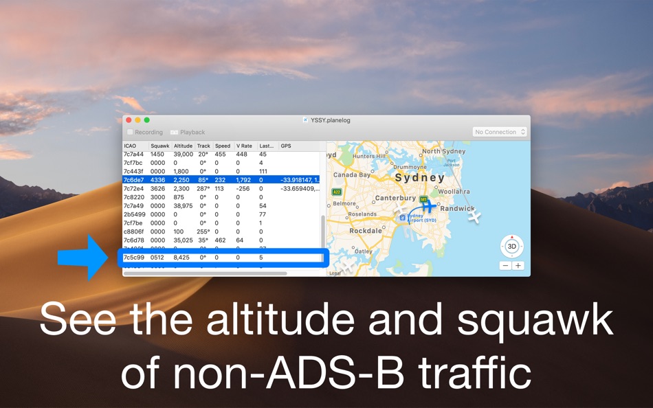
Max Planes decodes the data from ADS-B transponders and plots the data on a map. Connect a USB device and run a BEAST server (such as Dump1090 Mac Server) in order to view this data. Connect to another computer running dump1090 over a local area network to watch the planes it sees. There is no need for the internet to view live data from planes, everything can be collected locally.
See things you otherwise can't with normal plane spotting apps. You can see the altitude and squawk (not position) of planes in the spotting list on the left of planes with Mode C only transponders.
You can watch multiple data sources at once, save recordings as a file and rewatch them later. Send them to friends and they can re-watch them.
An internet connection is required to download initial map tiles if you wish to view planes on the moving map. After they are cached no internet is required.
螢幕擷取畫面


新功能
- 版本: 2.1
- 發佈日期:
- Fixed an issue with In-App Payment validation that was causing the app to exit unexpectedly.
價錢
- 今天: 免費
- 最小值: 免費
- 最大值: 免費
追蹤票價
開發人員
- Max Technology Labs PTY LTD
- 平台: iOS 應用程式 (1) macOS 應用程式 (2)
- 清單: 2 + 1
- 點數: 5 + 0 ¡
- 排名: 0
- 評測: 0
- 折扣: 0
- 影片: 0
- RSS: 訂閱
點數
未找到 ☹️
排名
未找到 ☹️
清單
未找到 ☹️
評測
成為第一個評論 🌟
其他資訊
- 版本: 2.1
- ID: au.com.mtlabs.planes
- 類別 :
macOS 應用程式›生產應用 - OS:
macOS,macOS 10.13 以上版本 - 大小:
896 Kb - 支援的語言 :
English - 內容分級:
4+ - Mac App Store 評分:
0 - 發佈日期:
- 發行日期:
聯絡人
你可能還喜歡
-
- Finger3D PRO
- macOS 應用程式: 生產應用 由: Gianluca Natalini
- $2.99
- 清單: 0 + 0 排名: 0 評測: 0
- 點數: 3 + 0 版本: 1.2 "Finger3D PRO is a 3D modeler for Your MAC. With "Finger3D PRO you can design all Your ideas in a 3D virtual reality world and explore them using the 3D and 2D views or the ... ⥯
-
- Stereonet3D
- macOS 應用程式: 生產應用 由: Nestor Cardozo
- 免費
- 清單: 1 + 0 排名: 0 評測: 0
- 點數: 0 + 0 版本: 6.5 Stereonet3D plots lines, planes and small circles on equal area or equal angle stereonets. The program can also plot the data in 3D, and if the data have lat-long info, on a ... ⥯