| Προγραμματιστής: | Tamas Balazs (3) | ||
| Τιμή: | Δωρεάν | ||
| Κατατάξεις: | 0 | ||
| Κριτικές: | 0 Γράψτε μια κριτική | ||
| Λίστες: | 0 + 0 | ||
| Βαθμοί: | 1 + 0 ¡ | ||
| Windows Store | |||
Περιγραφή
")
With MapCortex Free Edition you can:
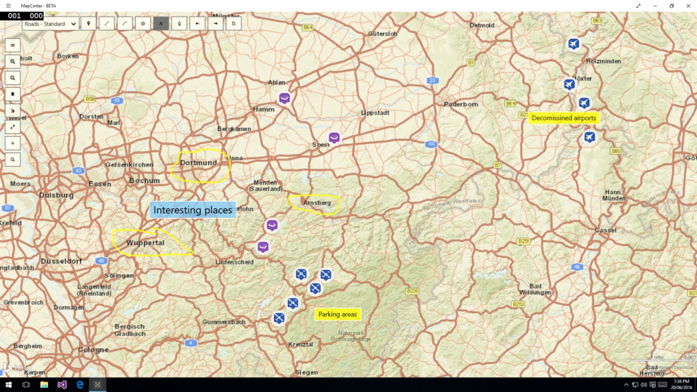
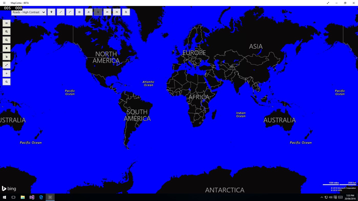
- Draw on streetmap or satellite view, add lines, polygons and icons as you please.
- Snap lines and polygons together while you draw them.
- Save this drawing and load it in next time you log in.
- Bookmark interesting areas on a map.
- Search and zoom for addresses using our address search functionality
Let's see these tools in details then. You can add lines, polygons and a vast array of icons to many different types of maps. More importantly though - if you happen to have a touch screen device you can just easily draw anything with your fingertip on the map choosing your preferred color and width of the line. This means you can just put a handwritten note to a map, save the image and email it to your friends and co-workers immediately.
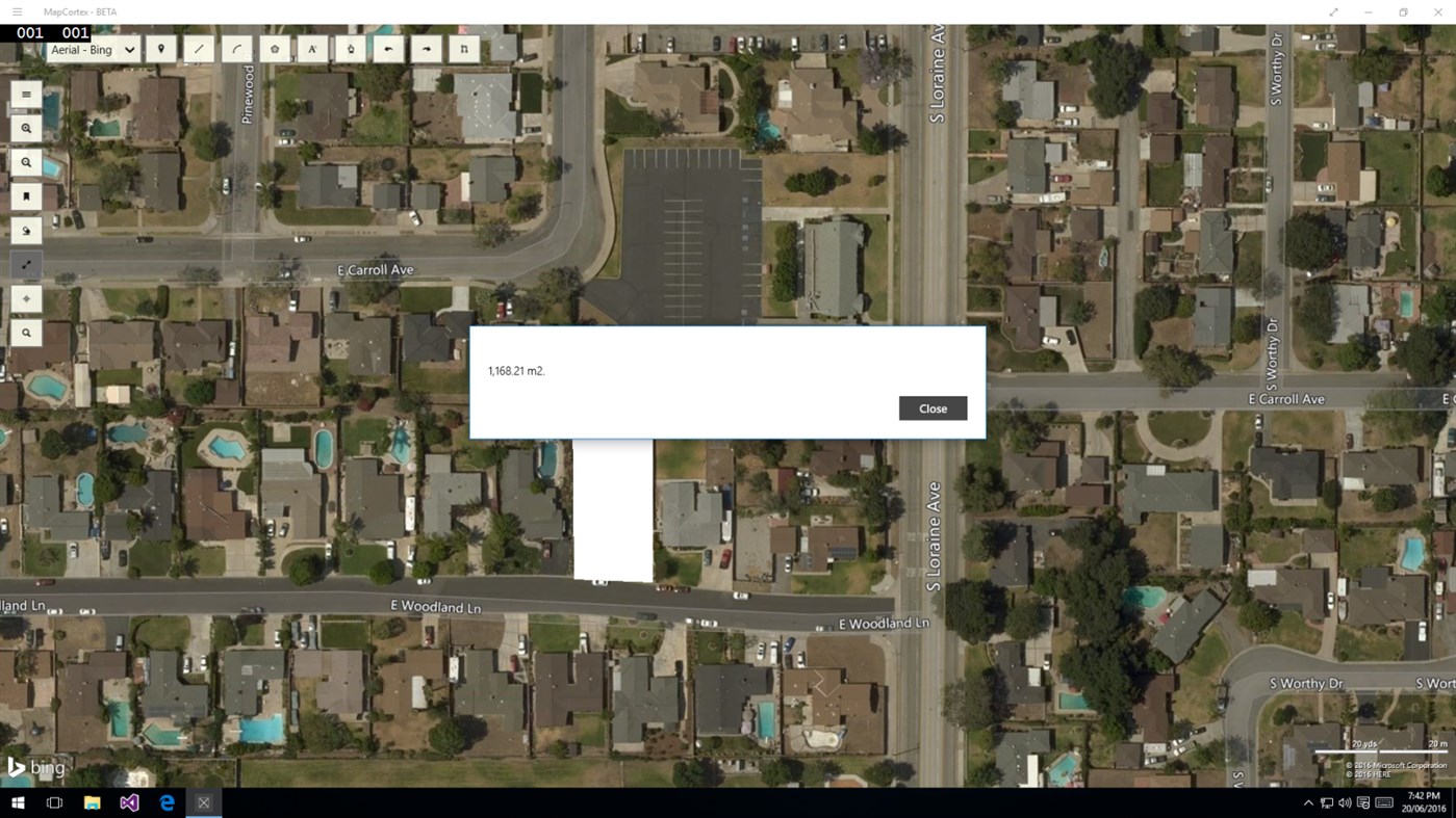
MapCortex also enables you to measure area or length of lines on a map, thus helping you to find out the size of a property you are interested to purchase or the length of your weekend trail. Furthermore, you can also search for addresses using our address search functionality and if you happened to find anything very interesting on a map, for example a historic monument or a possible UFO crash site you can easily bookmark it and go back to the location at any time.
Did we mention you can save and load your map drawings too? The current version enables you to have one project saved, but we are working on to enable you to have multiple saved projects as well.
With MapCortex Free Edition you can also create screenshots of the map view along with your individually added drawing elements. We save these screenshots on the MapCortex application folder on your OneDrive. Lastly, whilst you browse through your previously created screenshots you can simply just email them to your friends and colleagues from the screenshot management window without ever leaving the application.
Hope you enjoy using MapCortex Free Edition.
Στιγμιότυπα οθόνης
Τι νέο υπάρχει
- Εκδοχή: PC
- Ενημερώθηκε:
Τιμή
- Σήμερα: Δωρεάν
- Ελάχιστο: Δωρεάν
- Μέγιστο: Δωρεάν
Παρακολούθηση τιμών
Προγραμματιστής
- Tamas Balazs
- Πλατφόρμες: Android Εφαρμογές (1) Windows Εφαρμογές (2)
- Λίστες: 0 + 0
- Βαθμοί: 1 + 118 ¡
- Κατατάξεις: 0
- Κριτικές: 0
- Εκπτώσεις: 0
- Βίντεο: 0
- RSS: Εγγραφή
Βαθμοί
-

- 0 tom du 87
- +1

Κατατάξεις
0 ☹️
Λίστες
0 ☹️
Κριτικές
Γίνε ο πρώτος που θα αξιολογήσει 🌟
Πρόσθετες πληροφορίες
- Εκδοχή: PC
- Κατηγορία:
Windows Εφαρμογές›Πλοήγηση και χάρτες - Λειτουργικό σύστημα:
PC - Μέγεθος:
10 Mb - Υποστηριζόμενη γλώσσα:
English,Hungarian - Αξιολόγηση περιεχομένου:
EVERYONE - Windows Store Εκτίμηση:
0 - Ενημερώθηκε:
- Ημερομηνία έκδοσης:
Επαφές
- Ιστοσελίδα:
 https://mapcortex.com
- 🌟 Κοινή χρήση
- Windows Store
Μπορεί επίσης να σας αρέσει
-
- Map Downloader
- Windows Εφαρμογές: Πλοήγηση και χάρτες Με: Optimodzhu
- $1.99
- Λίστες: 0 + 0 Κατατάξεις: 0 Κριτικές: 0
- Βαθμοί: 0 + 0 Εκδοχή: PC Map Downloader helps you download various maps from the Internet. You can choose map source freely. We have provided many built-in map sources from ArcGIS, Google, Bing, Tianditu, Amap ⥯
-
- Map Mania
- Windows Εφαρμογές: Πλοήγηση και χάρτες Με: LocalJoost
- $0.99
- Λίστες: 0 + 0 Κατατάξεις: 0 Κριτικές: 0
- Βαθμοί: 1 + 4 (3.8) Εκδοχή: PC Map Mania allows you to view the world in all kinds of different ways. Bing Maps, Openstreetmap and Google maps are built in, but you can also add your own maps entering an URL from ... ⥯
-
- Map Meter
- Windows Εφαρμογές: Πλοήγηση και χάρτες Με: gjbsolutions
- Δωρεάν
- Λίστες: 0 + 0 Κατατάξεις: 0 Κριτικές: 0
- Βαθμοί: 0 + 2 (5.0) Εκδοχή: PC Estimate approximate distance and area between points on a map. When estimating an area make sure the polygon marking the area has no intersection points or else the calculation will ... ⥯
-
- Map - explore the world
- Windows Εφαρμογές: Πλοήγηση και χάρτες Με: Ensemble
- * Δωρεάν
- Λίστες: 0 + 0 Κατατάξεις: 0 Κριτικές: 0
- Βαθμοί: 0 + 0 Εκδοχή: PC Explore the world using this application with wonderful features. ⥯
-
- Easy Map 3D
- Windows Εφαρμογές: Πλοήγηση και χάρτες Με: Ivan Fuligni
- Δωρεάν
- Λίστες: 0 + 0 Κατατάξεις: 0 Κριτικές: 0
- Βαθμοί: 1 + 15 (3.5) Εκδοχή: PC With Easy Map 3D installed on your PC, you can view street and satellite 3D maps of the whole world (Bing Maps, OpenStreetMap and Mapbox). You can move around, widen, narrow, zoom in ... ⥯
-
- COM-MAP
- Windows Εφαρμογές: Πλοήγηση και χάρτες Με: COM-ADD
- * Δωρεάν
- Λίστες: 1 + 1 Κατατάξεις: 0 Κριτικές: 0
- Βαθμοί: 1 + 0 Εκδοχή: PC COM-MAP is a toolbox of digital mapping features. COM-MAP targets: private individuals (daily trips: residence-work, residence-school, residence-shopping, vacation outings and so on) ... ⥯
-
- GPS Map+
- Windows Εφαρμογές: Πλοήγηση και χάρτες Με: WzzT
- Δωρεάν
- Λίστες: 0 + 0 Κατατάξεις: 0 Κριτικές: 0
- Βαθμοί: 4 + 289 (4.6) Εκδοχή: PC Good map with good tools: Searching place and navigating there. Getting the weather information on map. Tell your friends where are you and how to find you! Share your location and ... ⥯
-
- Earth View - Map 3D
- Windows Εφαρμογές: Πλοήγηση και χάρτες Με: wolfSYS
- * Δωρεάν
- Λίστες: 1 + 0 Κατατάξεις: 0 Κριτικές: 0
- Βαθμοί: 1 + 242 (3.4) Εκδοχή: PC View the earth in real 3D! Walk the streets in many cities with street view! - view cool places on that earth like never before! - create animated scenes and save them! - organize the ... ⥯
-
- My Map
- Windows Εφαρμογές: Πλοήγηση και χάρτες Με: Thomas Gössi
- Δωρεάν
- Λίστες: 0 + 0 Κατατάξεις: 0 Κριτικές: 0
- Βαθμοί: 0 + 1 (5.0) Εκδοχή: PC My Map displays the geographical position on the map where you are currently located. The position is automatically updated when you move. The map can be displayed as road map or ... ⥯
-
- Geo Elevation: Map Elevation Chart Creator
- Windows Εφαρμογές: Πλοήγηση και χάρτες Με: ObjectGraph
- $4.99
- Λίστες: 0 + 0 Κατατάξεις: 0 Κριτικές: 0
- Βαθμοί: 1 + 4 (4.0) Εκδοχή: PC Geo Elevation is a powerful tool to build a cross-sectional elevation chart from any paths/points on the map with a few clicks. Simply create a path and click on "Get Elevation" you ... ⥯
-
- My Map Routes
- Windows Εφαρμογές: Πλοήγηση και χάρτες Με: DSBT Software LLC
- $2.99
- Λίστες: 0 + 0 Κατατάξεις: 0 Κριτικές: 0
- Βαθμοί: 0 + 0 Εκδοχή: PC With My Map Routes, you can use an intuitive visual interface to build your daily jogging, walking, biking, and driving routes and find out how long they are. You can even use our ... ⥯
-
- GOT-MAP
- Windows Εφαρμογές: Πλοήγηση και χάρτες Με: TONIC SOFT
- $4.79
- Λίστες: 0 + 0 Κατατάξεις: 0 Κριτικές: 0
- Βαθμοί: 0 + 0 Εκδοχή: PC Show and Download Maps Tiles in UWP map control Offline map download Switch between online and offline maps dynamically ⥯
-
- Expedition Map Tool
- Windows Εφαρμογές: Πλοήγηση και χάρτες Με: Sdell
- Δωρεάν
- Λίστες: 0 + 0 Κατατάξεις: 0 Κριτικές: 0
- Βαθμοί: 0 + 1 (1.0) Εκδοχή: PC EMT is a tool designed to support serious travelers who needs advanced information and tools during the trip. EMT use Microsoft vector maps so it can be downloaded and used offline. ... ⥯
-
- Global ATM map
- Windows Εφαρμογές: Πλοήγηση και χάρτες Με: alexchukanov
- Δωρεάν
- Λίστες: 0 + 0 Κατατάξεις: 0 Κριτικές: 0
- Βαθμοί: 0 + 0 Εκδοχή: PC The program shows banks, ATM, payment terminals (kiosks) on the map worldwide using Microsoft Binq Spatial Data Services. ⥯