| Desenvolvedor: | Lim Geomatics Inc. (7) | ||
| Preço: | Grátis | ||
| Classificações: | 0 | ||
| Resenhas: | 0 Escrever um comentário | ||
| Listas: | 0 + 0 | ||
| Pontos: | 0 + 0 ¡ | ||
| Windows Store | |||
Descrição
")
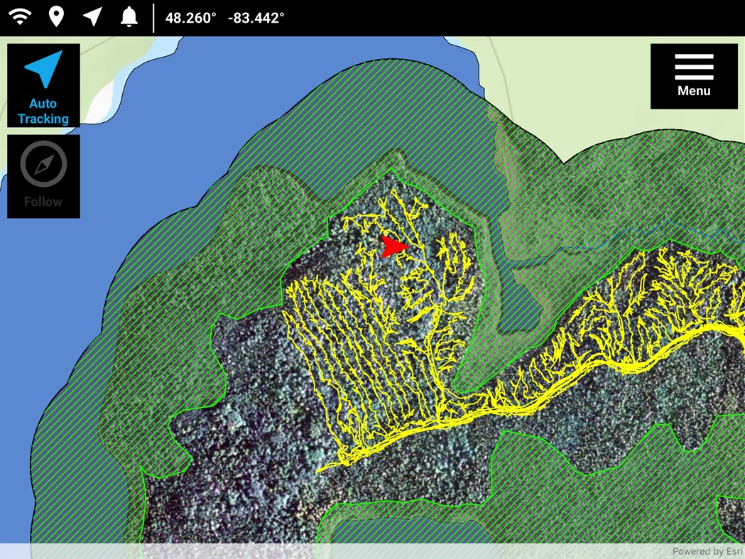
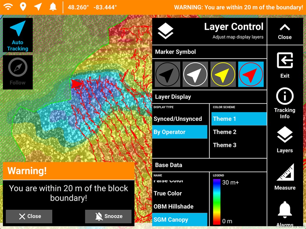
Operational Tracker is a simple, turnkey GIS solution to help you track harvesting equipment – feller bunchers, forwarders, harvesters, and skidders – in real-time, and use this information to monitor and quantify equipment performance and productivity. In addition, you can avoid trespasses with warnings sent to you well before you’re too close to a boundary.
With the Operational Tracker on hand, not only will you have a competitive edge in the forest industry, your equipment operators also benefit by having corporate GIS data at their fingertips to enable them to do their work better and faster, while remaining safe and compliant.
How Operational Tracker benefits you
With Operational Tracker, you can get updates that identify productivity and efficiency of your harvesting equipment. No longer will your forest managers need to estimate where the equipment has been or how productive they were – our app does this for you. In fact, Operational Tracker empowers you to see how you are doing, so you can get your job done more efficiently.
Through the power of an iOS, Android or Windows tablet and proprietary Lim Geomatics algorithms, Operational Tracker™ can report on productive machine hours and a wide range of productivity statistics. For operations that require precise navigation, Operational Tracker™ can be paired with an external GNSS device to pinpoint the position of machinery with an accuracy of 50 cm, even while under forest canopy.
Capturas de ecrã

Novidades
- Versão: PC
- Atualizado:
Preço
- Hoje: Grátis
- Mínimo: Grátis
- Máximo: Grátis
Monitorizar preços
Desenvolvedor
- Lim Geomatics Inc.
- Plataformas: Android Apps (3) iOS Apps (2) Windows Apps (2)
- Listas: 0 + 0
- Pontos: 0 + 2 ¡
- Classificações: 0
- Resenhas: 0
- Descontos: 0
- Vídeos: 0
- RSS: Subscrever
Pontos
0 ☹️
Classificações
0 ☹️
Listas
0 ☹️
Resenhas
Seja o primeiro a comentar 🌟
Informações adicionais
- Versão: PC
- Categoria:
Windows Apps›Navegação e mapas - Sistemas operacionais:
PC - Tamanho:
60 Mb - Idioma compatível:
Arabic,Bosnian,Bulgarian,Catalan,Chinese,Croatian,Czech,Danish,Dutch,English,Estonian,Finnish,French,German,Greek,Hebrew,Hungarian,Indonesian,Italian,Japanese,Korean,Latvian,Lithuanian,Norwegian,Polish,Portuguese,Romanian,Russian,Slovak,Slovenian,Spanish,Swedish,Thai,Turkish,Ukrainian,Vietnamese - Classificação do conteúdo:
EVERYONE - Windows Store Avaliação:
0 - Atualizado:
- Data de lançamento:
Contactos
- 🌟 Compartilhar
- Windows Store
Você também pode gostar de
-
- Distance Tracker
- Windows Apps: Navegação e mapas Por: vixezApps
- $0.99
- Listas: 0 + 0 Classificações: 0 Resenhas: 0
- Pontos: 0 + 1 (5.0) Versão: PC Want to track a walk, bike ride, car ride, ... ? Then Distance Tracker is exactly what you need. Easily track distances you travel, even when the app is minimized. Distance Tracker ... ⥯
-
- Irish Transport Tracker
- Windows Apps: Navegação e mapas Por: CianG
- Grátis
- Listas: 0 + 0 Classificações: 0 Resenhas: 0
- Pontos: 0 + 0 Versão: PC Allows the user to access the TFI API in a user-friendly interface. Users can add Bus Éireann, Expressway, Dublin Bus, Iarnród Éireann and Luas stations/stops to the application. ⥯
-
- SatelliteMap
- Windows Apps: Navegação e mapas Por: KingBTC
- $4.99
- Listas: 0 + 0 Classificações: 0 Resenhas: 0
- Pontos: 0 + 0 Versão: PC This application was developed by Esrishichina in shanghai, china using the lastest release of the ArcGIS Runtime100.1 for UWP. The 3d view displays approximately 1,250 satelites in ... ⥯
-
- Buses Due: London bus times
- Windows Apps: Navegação e mapas Por: Lama Apps
- * Grátis
- Listas: 0 + 0 Classificações: 0 Resenhas: 0
- Pontos: 0 + 1 (5.0) Versão: PC Meet London's best Bus app that is making everyone's public transport journeys easier. Buses Due provides you with live bus times and helpful transport information. Try it yourself for ⥯