Αποθηκευμένα
Επίλεξε το όνομα που θα εμφανίζεται στο μενού Αποθηκευμένα.
Εγινε!
| Προγραμματιστής: | Garmin (83) | ||
| Τιμή: | Δωρεάν | ||
| Βαθμολογία: | 53,500 | ||
| Κατατάξεις: | 0 | ||
| Σχόλια: | 0 Δημοσίευση σχολίου | ||
| Λίστες: | 1 + 1 | ||
| Βαθμοί: | 1 + 2,243 (2.9) ¡ | ||
| +1 Βαθμοί | |||
Περιγραφή
")
A COMPLETE PACKAGE
• INTERNATIONALLY RENOWNED NAVIONICS® CHARTS: Use them offline along with multiple overlays, so you can be more aware of what’s above and below the water.
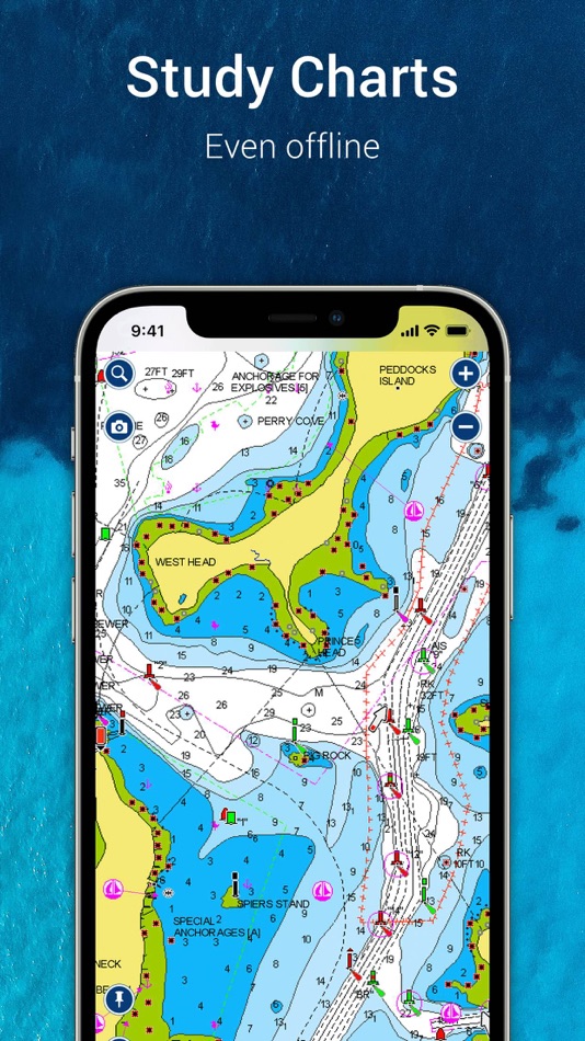
- NAUTICAL CHART: Use this premier marine reference to study port plans, anchorages and safety depth contours, locate navaids, marine services and more.
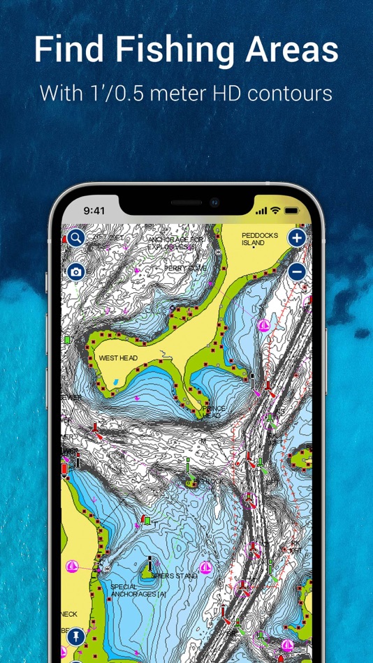
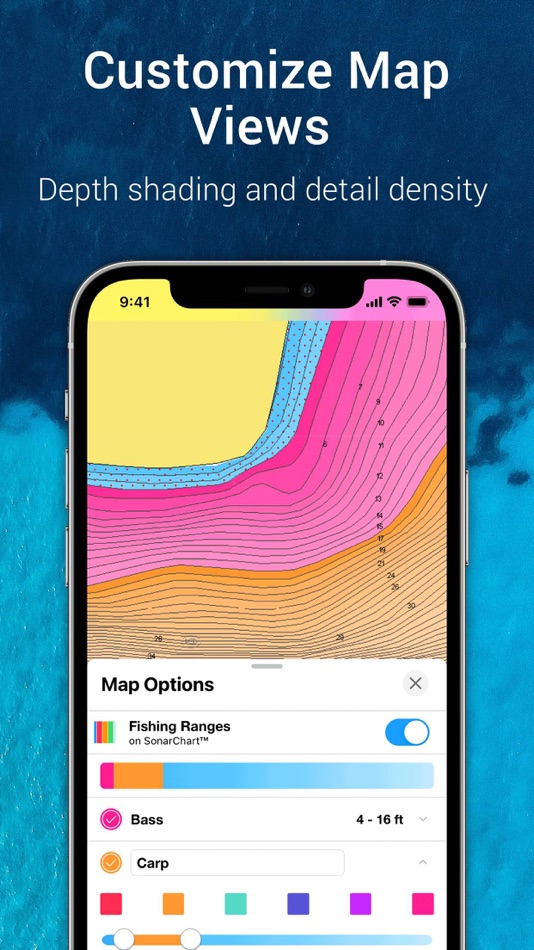
- SONARCHART™ HD BATHYMETRY MAPS: Extraordinary 1’ (0.5 meter) HD bottom contour detail is the ideal tool for locating new fishing areas.
- U.S. GOVERNMENT CHARTS (NOAA): These are available within the following coverages: U.S. and Canada, Mexico, Caribbean to Brazil.
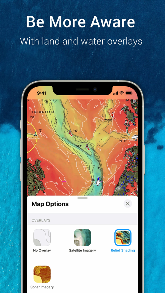
- OVERLAYS: The relief shading overlay allows you to have a better understanding of bottom topography for improved fishing and diving. Sonar imagery reveals bottom hardness clearly and in vivid color on select lakes. Want more? Display satellite imagery on land and water.
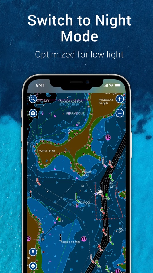
- MAP OPTIONS: Change chart-overlay combinations to customize chart views, activate night mode, highlight shallow areas, target multiple fishing ranges and more.
- DAILY UPDATES: Benefit of thousands of daily updates worldwide.
• TOOLS FOR PLANNING AND ENJOYING YOUR DAY
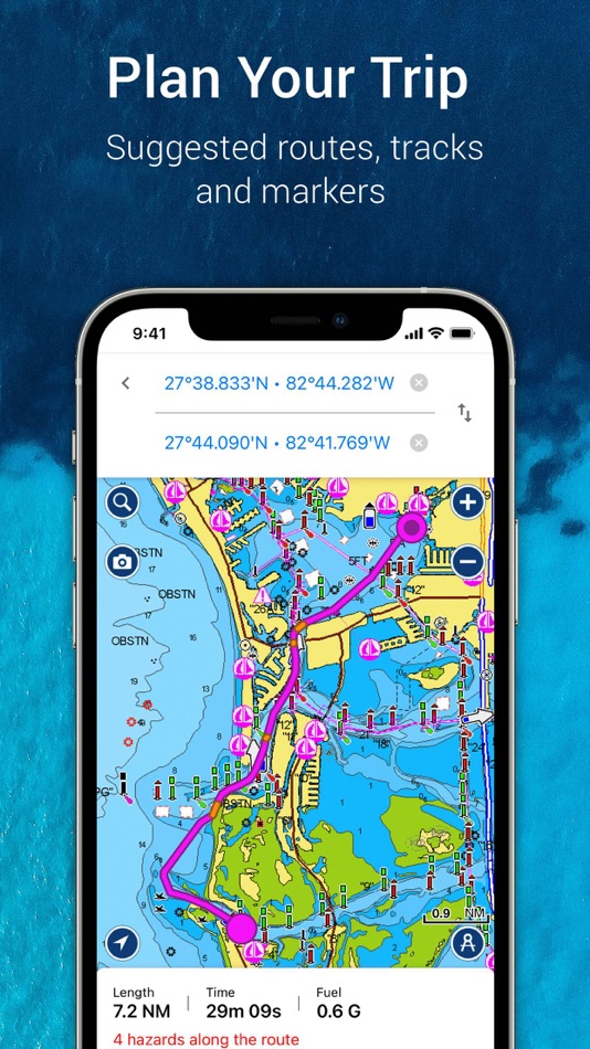
- AUTO GUIDANCE+TM TECHNOLOGY**: Easily plan your trip with a suggested dock-to-dock path based on chart data and navigation aids. Get ETA, distance to arrival, heading to waypoint, fuel consumption and more.
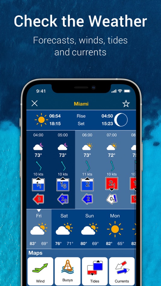
- WEATHER AND TIDES: Knowing conditions before heading out is crucial. Access real-time weather data, daily and hourly forecasts as well as wind, weather buoys, tides and currents.
- MARKERS, TRACKS, DISTANCE: Place a marker on a good anchorage spot or where you reeled in a big fish. Record your track, take photos and videos within the app, and look back at your day anytime. Easily check distance among two points.
• AN ACTIVE AND HELPFUL COMMUNITY
- COMMUNITY EDITS and the ACTIVECAPTAIN® COMMUNITY: Obtain and contribute useful local knowledge along with thousands of fellow boaters, such as points of interest, navigation aids and valuable recommendations from people with firsthand experience of the local environment.
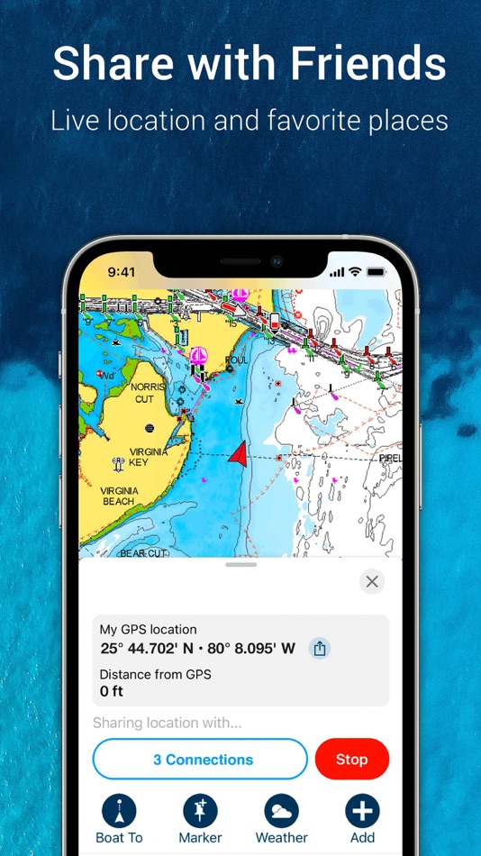
- CONNECTIONS: Stay in touch with your friends and fellow boaters by sharing your live location, tracks, routes and markers to easily meet on the water or let them check out your adventures.
- GPX IMPORT/EXPORT: Share your saved data outside the app or transfer it to your chartplotter.
- SHARE MAP OBJECTS: Share a marina, repair shop or any other location outside the app.
• EXTERNAL DEVICE-FRIENDLY FOR MORE FEATURES
- PLOTTER SYNC: If you own a compatible chartplotter, sync it with the app to transfer routes and markers, activate, update or renew your Navionics chartplotter card subscription.
- SONARCHART LIVE MAPPING FEATURE***: Connect with a compatible sonar/plotter, and create your own maps in real time while navigating.
- AIS: Connect to a compatible AIS receiver with Wi-Fi® connectivity to see nearby marine traffic. Set a safe range, and receive visual and aural alerts to signal potential collisions.
NOTES:
*You can manage your subscription anytime, and you can turn auto-renewal off.
**Auto Guidance+ is for planning purposes only and does not replace safe navigation operations
***Free features
Updates are available with iOS 16.0 or higher. A tablet device with Wi-Fi connectivity locates your approximate position if it is connected to Wi-Fi. A tablet Wi-Fi + 3G model operates similarly to a phone device with GPS.
Wi-Fi is a registered trademark of the Wi-Fi Alliance. iOS is a trademark licensed to Apple, Inc.
Στιγμιότυπα οθόνης
Ad
Ιστορία τιμών
- Τρέχουσα τιμή: Δωρεάν
- Ελάχιστο: Δωρεάν
- Μέγιστο: Δωρεάν
Παρακολούθηση τιμών
Βαθμολογία AppAgg
53,500
Εκτιμώμενη βαθμολογία AppAgg για
Navionics® Boating
53,500
Οι υψηλότερες βαθμολογίες συνήθως σημαίνουν ισχυρότερα σήματα στο AppAgg.
Βασισμένο σε: 🔥 δημοτικότητα · ⭐ αξιολογήσεις χρηστών · 🕒 επικαιρότητα · 🏷️ προσφορές · 🏬 δεδομένα καταστημάτων · 👥 δραστηριότητα κοινότητας
Υπολογίζεται εκ νέου καθημερινά με βάση τα πιο πρόσφατα δεδομένα του AppAgg.
URL μικρού μήκους: Αντιγράφηκε!
Πρόσθετες πληροφορίες
- Ημερομηνία έκδοσης:
- Κατηγορία:
iOS Εφαρμογές›Πλοήγηση - Λειτουργικό σύστημα:
iPad,iPhone,iOS 16.0 και νεότερες εκδόσεις - Μέγεθος:
120 Mb - Υποστηριζόμενη γλώσσα:
English,French,German,Italian,Spanish - Αξιολόγηση περιεχομένου:
4+ - App Store Εκτίμηση:
2.9(2,243) - Ιστοσελίδα:
 https://www.navionics.com/apps/navionics-boating
Προγραμματιστής
- Garmin
- Πλατφόρμες: Android Εφαρμογές (43) iOS Εφαρμογές (36) macOS Εφαρμογές (4)
- Λίστες: 9 + 2
- Βαθμοί: 36 + 1,794,820 ¡
- Κατατάξεις: 5 (2)
- Σχόλια: 0
- Εκπτώσεις: 0
- Βίντεο: 6
- RSS: Εγγραφή
Λίστες (1)
- Navionics® Boating

Βαθμοί (1)
-

- 1 Иван Яковлев
- +1
Κατατάξεις (0)
0 ☹️
Σχόλια (0)
Γίνε ο πρώτος που θα σχολιάσει 🌟
«Navionics® Boating». Πλατφόρμα: iOS. Κατηγορία: Πλοήγηση. Προγραμματιστής: «Garmin». Πρώτη κυκλοφορία: . Τελευταία ενημέρωση: . Τρέχουσα τιμή: δωρεάν. Αυτός ο τίτλος δεν έχει λάβει ακόμη αξιολογήσεις ή κριτικές στο AppAgg. Λίστες: δημόσιες 1, ιδιωτικές 1. Σημεία παρακολούθησης: επιβεβαιωμένα 1, έμμεσα 2,243. Κατάστημα: App Store. Αξιολόγηση καταστήματος: 2.9. Ψήφοι: 2,243. Διαθέσιμες γλώσσες: English, French, German, Italian, Spanish. Το AppAgg παρακολουθεί το ιστορικό τιμών, τις αξιολογήσεις και τα σχόλια των χρηστών για «Navionics® Boating». Ακολουθήστε μελλοντικές εκπτώσεις και ενημερώσεις μέσω RSS. Το AppAgg δεν φιλοξενεί εφαρμογές ούτε διανέμει λογισμικό. Όλα τα εμπορικά σήματα, τα λογότυπα και τα στιγμιότυπα οθόνης ανήκουν στους αντίστοιχους κατόχους τους.
- 🌟 Κοινή χρήση
- App Store
Παρόμοια
-
- Wavve Boating: Marine Boat GPS
- iOS Εφαρμογές: Πλοήγηση Με: Wavve Boating INC
- Δωρεάν
- Λίστες: 0 + 1 0 0
- Βαθμοί: 1 + 4,932 (4.7) 96k Εκδοχή: 5.7.1 Ever have a stressful day navigating on the water? Wanted to know more about the conditions you are about to head into? Are you looking for exciting places to explore, the best place ... ⥯
-
- i-Boating: Marine Charts & Gps
- iOS Εφαρμογές: Πλοήγηση Με: Bist LLC
- Δωρεάν
- Λίστες: 0 + 1 0 0
- Βαθμοί: 1 + 14,211 (4.5) 178k Εκδοχή: 171.0.0 This App offers access to Marine Charts for USA,Canada,UK/Ireland,Germany,Netherlands/Holland & Europe Rivers (Danube,Drava,Rhein etc). Coverage includes NOAA marine vector ... ⥯
-
- Argo - Boating Navigation
- iOS Εφαρμογές: Πλοήγηση Με: Argo Navigation, LLC
- Δωρεάν
- Λίστες: 0 + 1 0 0
- Βαθμοί: 0 + 6,011 (4.9) 139k Εκδοχή: 3.4.0 The top navigation and planning app for boaters easy-to-use like Google Maps, but built for the water. Works on ICW, offshore, rivers & lakes across the U.S. and Canada. Powerful ... ⥯
-
- Aqua Map Boating
- iOS Εφαρμογές: Πλοήγηση Με: GEC s.r.l.
- * Δωρεάν
- Λίστες: 0 0 0
- Βαθμοί: 0 + 12,740 (4.7) 164k Εκδοχή: 53.11 Free 14-day trial for all subscriptions Aqua Map offers weekly updated OFFICIAL NAUTICAL CHARTS (NOAA) for marine navigation. Purchase a chart subscription for the area of your ... ⥯
-
- Savvy Navvy Boating Navigation
- iOS Εφαρμογές: Πλοήγηση Με: savvy navvy
- Δωρεάν
- Λίστες: 0 + 1 0 0
- Βαθμοί: 2 + 6,621 (4.7) 129k Εκδοχή: 2.2.21730 Savvy Navvy: Your All-in-One Marine Navigation App Savvy Navvy is the ultimate marine navigation tool that simplifies charts, weather forecasts, tides, GPS tracking, and route planning ⥯
-
- C-MAP: Boating
- iOS Εφαρμογές: Πλοήγηση Με: Navico Norway AS
- Δωρεάν
- Λίστες: 0 + 1 0 0
- Βαθμοί: 0 + 2,199 (4.5) 86k Εκδοχή: 4.6.0 The C-MAP® App is the perfect companion for recreational boaters and water-lovers. Available on Mobile, Tablet or PC, you ll always be able to access the most up to date C-MAP charts, ... ⥯
-
- iNavX: Marine Navigation
- iOS Εφαρμογές: Πλοήγηση Με: NavX Studios LLC
- Δωρεάν
- Λίστες: 0 0 0
- Βαθμοί: 7 + 21,058 (4.8) 159k Εκδοχή: 5.8.1 Marine navigation is made easy with iNavX - the world's #1 handheld Chartplotter. Access marine charts, maps, weather, AIS and more! iNavX is the only app to give you complete ... ⥯
-
- ActiveCaptain®
- iOS Εφαρμογές: Πλοήγηση Με: Garmin
- Δωρεάν
- Λίστες: 2 0 0
- Βαθμοί: 13 + 4,704 (4.0) 115k Εκδοχή: 43.0 The free ActiveCaptain app creates a powerful connection between your compatible mobile device and Garmin chartplotter, charts, maps and the boating community. Whether you use your ... ⥯
-
- GPS Speedometer MPH Tracker
- iOS Εφαρμογές: Πλοήγηση Με: BITHAUS.TECH, UNIPESSOAL LDA
- Δωρεάν
- Λίστες: 0 0 0
- Βαθμοί: 1 + 12,603 (4.7) 150k Εκδοχή: 8.0.14 Transform every journey into valuable data with GPS Speedometer - the most comprehensive speed tracking app for driving, cycling, boating, and beyond. Experience professional-grade ... ⥯
-
- BRP GO!: Maps & Navigation
- iOS Εφαρμογές: Πλοήγηση Με: BRP Inc.
- Δωρεάν
- Λίστες: 0 0 0
- Βαθμοί: 0 + 2,598 (4.2) 78k Εκδοχή: 4.1.2 EXPERIENCE THE FUTURE OF RIDING WITH BRP GO! Your one-stop source for a connected riding experience. > A ride on water? Explore locations using detailed maps and save your trips, ... ⥯
-
- Compass ⊘
- iOS Εφαρμογές: Πλοήγηση Με: Christophe Pereira
- Δωρεάν
- Λίστες: 0 0 0
- Βαθμοί: 1 + 6,170 (4.6) 98k Εκδοχή: 14.4 Compass : The Most Elegant and Accurate Compass App for iPhone and iPad Transform your iPhone and iPad into a beautifully designed, highly accurate compass. With its rustic aesthetic ... ⥯
-
- Orca: Boat GPS, Charts, Routes
- iOS Εφαρμογές: Πλοήγηση Με: Orca Technologies AS
- Δωρεάν
- Λίστες: 0 + 1 0 0
- Βαθμοί: 0 + 277 (4.5) 51k Εκδοχή: 2026.17.1 Access accurate marine charts, intelligent routing, live AIS, and weather forecasts with Orca. Trusted by hundreds of thousands of sailors and powerboaters in the United States and ... ⥯
-
- Boat Beacon
- iOS Εφαρμογές: Πλοήγηση Με: Pocket Mariner Ltd.
- $14.99
- Λίστες: 0 0 0
- Βαθμοί: 0 + 825 (4.6) 69k Εκδοχή: 5.1 Boat Beacon is an internet AIS receiver and transmitter for your iPhone and iPad. It is the only AIS ship tracking app to provide Collision Warnings, share your boat s position & use ... ⥯
-
- TZ iBoat – Marine Navigation
- iOS Εφαρμογές: Πλοήγηση Με: Nobeltec, Inc.
- Δωρεάν
- Λίστες: 0 0 0
- Βαθμοί: 3 + 806 (4.7) 51k Εκδοχή: 3.3.6 Navigate the seas with the world s #1 marine charts app for coastal boating, sailing, and fishing with or without internet. GPS, anchoring, radar, AIS Online, tides & tidal currents... ⥯
Μπορεί επίσης να σας αρέσει
Προβλήθηκαν πρόσφατα
Τελευταία ενημέρωση:
Τελεστές αναζήτησης που μπορείτε να χρησιμοποιήσετε με το AppAgg