| Concepteur: | Kalimex-Consulting s.r.o. @Blocoware & Stanislav Dvoychenko (5) | ||
| Prix: | Gratuit | ||
| Classements: | 0 | ||
| Avis: | 0 Rédiger un avis | ||
| Commentaires: | 0 Publier un commentaire | ||
| Listes: | 1 + 1 | ||
| Points: | 1 + 2,633 (4.7) ¡ | ||
| App Store | |||
Description
")
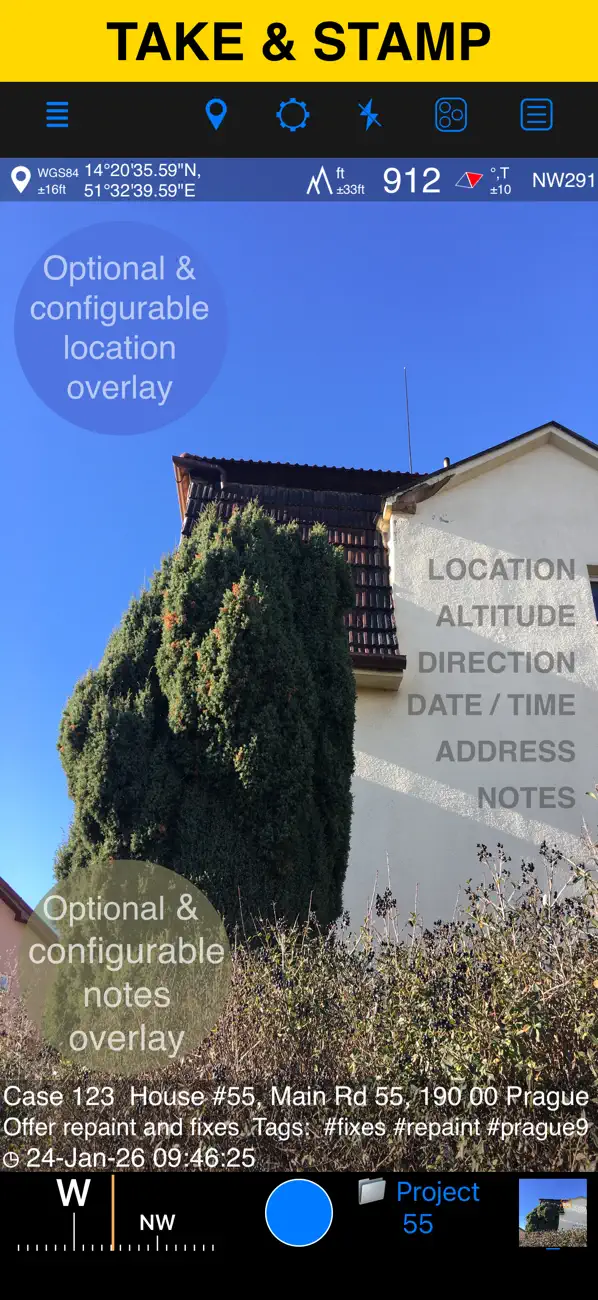
LOCATION OVERLAY
Supports decimal, DM, DMS, UTM, and MGRS coordinate formats.
True or magnetic heading, in degrees or mils.
Accuracy and altitude in feet or meters.
CAMERA AND CAPTURE SETTINGS
Save photos automatically or open in preview to annotate before saving.
Option to save a copy to the photo library — original, stamped, or both.
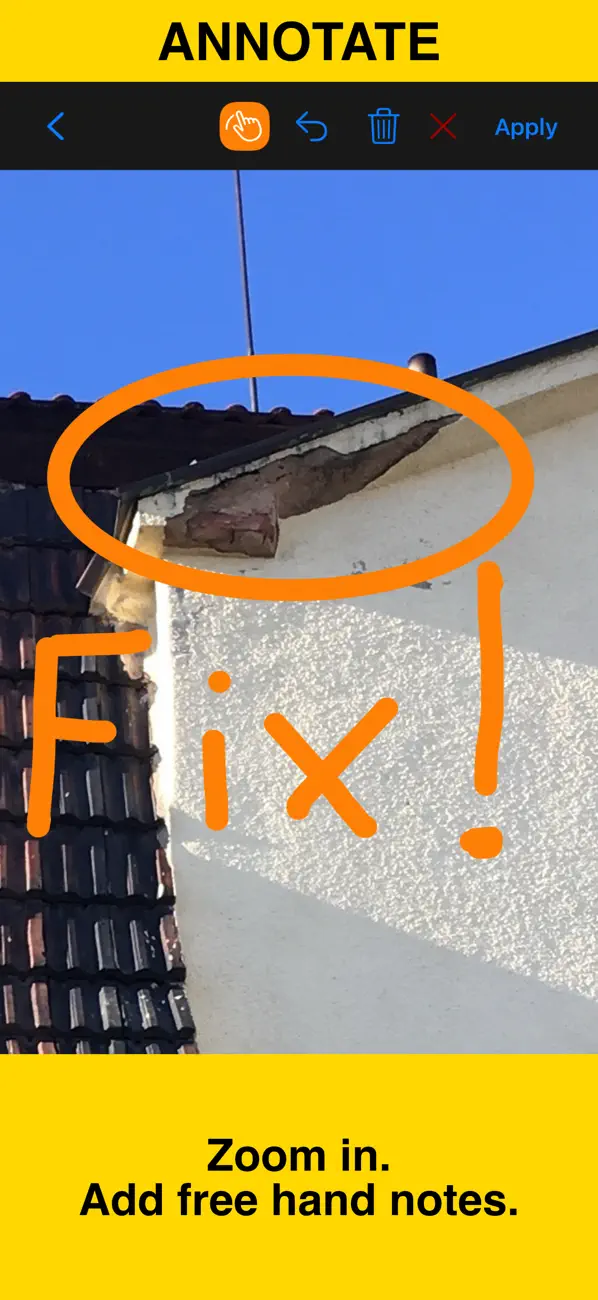
ANNOTATE AND COMMENT
Before or after saving, zoom in/out and draw directly on the photo using your finger or Apple Pencil.
Crop, resize, rotate, or tilt the photo before or after saving.
Notes overlay supports Title, Note, Tags/Folder, and Address.
Address can be auto-filled from GPS or entered manually.
Edit notes and add annotations later (MENU > POINTS > tap an image).
Tapping a point row opens the editor, where you can add an audio note.
Timestamp support many formats and languages.
Scan QR codes, barcodes, or text and use the result for the title or note field.
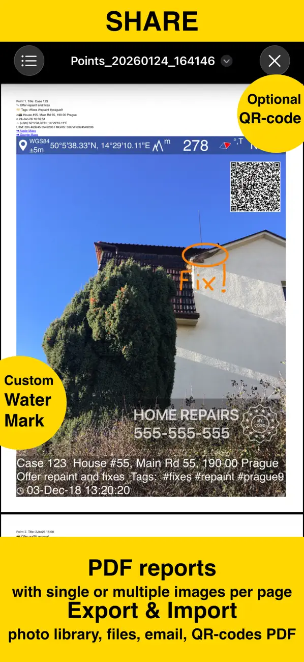
WATERMARK
The Pro Pack upgrade removes the basic version watermark and allows you to set up a watermark with your own image, text, and colors, if needed.
SHARE AND EXCHANGE
Share multiple points via MENU > POINTS, or entire collections via MENU > POINT COLLECTIONS.
Images can be shared with or without location/notes text, and with or without overlays.
Photo filenames can include title, note, address, tags/folder name, collection, coordinates, altitude, heading, or capture date.
To transfer complete points and images to another device, use KMZ (Google Earth archive) — includes photos, notes, annotations, and audio.
PDF REPORTS
Generate and share PDF documents for the selected photos/points or whole collection/folder, with options for the number of images per page and photo descriptions.
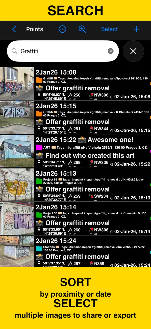
ORGANIZE, SEARCH & SORT
You can organize images into collections/folders. Existing images/points can be moved between collections.
The MENU > POINTS screen enables you to search by point/image notes, address, or tags fields, filter by creation month, sort by proximity, or show points/images only for a specific collection.
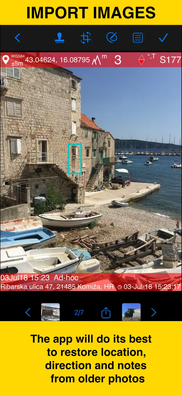
IMPORT
MENU > IMPORT FROM LIBRARY will allow you to pick and import a photo from the photo library. The app will do its best to parse TIFF/EXIF/GPS/IPTC data in the photo to restore location, direction, and notes for the stamp.
NAVIGATE
You can navigate to a point/image by opening it via MENU > POINTS and using the Navigate button in the point editor screen.
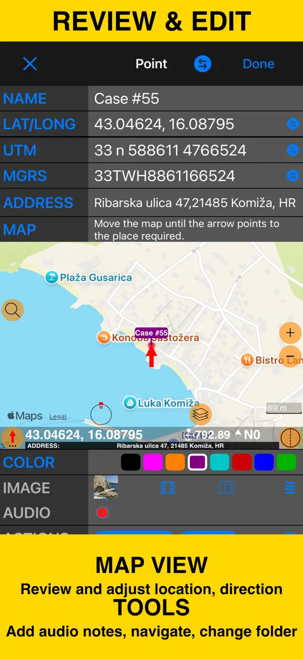
MAP VIEW
An image/point’s location on a map can be reviewed by tapping on the MAP button in the point editor screen (MENU > POINTS > tap on a point row).
== PRO PACK UPGRADE ==
You can do a lot with the basic functions in the app. The PRO PACK upgrade adds:
- Ability to create additional point/image collections.
- Enables sharing of more than 5 points/images at once.
- Export/import capabilities — in particular, KMZ export/import enables transfer of collections or selected waypoints between devices.
- Ability to save hand-drawn annotations for the image.
- Crop, resize, rotate, or tilt the photo before or after saving.
- Extra protection of your work and privacy with PIN code or biometric-based access options.
- Removes the basic version watermark and allows you to apply a custom watermark with your image, text, and colors.
Terms of Use: https://www.apple.com/legal/internet-services/itunes/dev/stdeula/
Ad
Captures d'écran
Historique des prix
- Aujourd’hui: Gratuit
- Minimum: Gratuit
- Maximum: Gratuit
Suivre l'évolution des prix
Nouveautés
- Version: 5.0.1
- Mis à jour:
- • Fixed alignment of landscape photo preview on iOS 26.3 and iPadOS 26.3. The top part could be hidden behind the navigation bar and required scrolling — now fixed.
• Fixed photo capture screen not setting landscape orientation properly after a fresh app start on the latest iOS 15 version.
• Improved iPadOS 16–26 multitasking compatibility for the camera (Split View / Stage Manager).
◆ Don’t miss the major changes from the previous version:
■ Trash for Deleted Photos & Points
Accidentally deleted a photo? Now you can get it back. On your first delete, you'll be asked whether to enable Trash protection—or configure it anytime in Settings > Deletion & Trash Management. With Trash enabled, deleted items stay recoverable for 30 days before permanent removal. Access Trash from the collections filter in your points/photos list (MENU > Points) or in the settings.
Commentaires (0)
Soyez le premier à commenter 🌟
Concepteur
- Kalimex-Consulting s.r.o. @Blocoware & Stanislav Dvoychenko
- Plateformes: iOS Applications (5)
- Listes: 2 + 1
- Points: 4 + 4,775 ¡
- Classements: 0
- Avis: 0
- Commentaires: 0
- Remises: 0
- Vidéos: 0
- RSS: S'abonner
Points (1)
-

- 29,676 Lance Eliakim Sotto
- +1

Classements (0)
0 ☹️
Listes (1)
- GPS Camera 55. Field Survey

Avis (0)
Soyez le premier à donner votre avis 🌟
Informations supplémentaires
- Version: 5.0.1
- Catégorie:
iOS Applications›Navigation - Systèmes d'exploitation:
Apple Watch,iPad,iPhone,iOS 15.6 ou version ultérieure - Taille:
73 Mb - Langues prises en charge:
Chinese,English,French,German,Japanese,Korean,Polish,Portuguese,Russian,Spanish,Turkish - Classification du contenu:
4+ - App Store Note:
4.7(2,633) - Mis à jour:
- Date de sortie:
«GPS Camera 55. Field Survey». Plateforme : iOS. Catégorie : Navigation. Développeur : «Kalimex-Consulting s.r.o. @Blocoware & Stanislav Dvoychenko». Première version : . Dernière mise à jour : . Prix actuel : gratuit. Ce titre n'a pas encore reçu de notes ou d'avis sur AppAgg. Listes : publiques 1, privées 1. Points suivis : confirmés 1, indirects 2,633. Magasin : App Store. Évaluation du magasin : 4.7. Votes : 2,633. Langues disponibles : Chinese, English, French, German, Japanese, Korean, Polish, Portuguese, Russian, Spanish, Turkish. AppAgg suit l'historique des prix, les notes et les commentaires des utilisateurs pour «GPS Camera 55. Field Survey». Suivez les futures réductions et mises à jour via RSS. AppAgg n'héberge pas d'applications et ne distribue pas de logiciels. Toutes les marques, logos et captures d'écran appartiennent à leurs propriétaires respectifs.
- 🌟 Partager
- App Store
Ad
Similaires
-
- GPS Speedometer: Speed Tracker
- iOS Applications: Navigation De: Mikhail Nikitsin
- Gratuit
- Listes: 0 + 0 Classements: 0 Avis: 0
- Points: 0 + 5,396 (4.5) 0 Version: 1.8.0 GPS Speedometer is the most elegant and unique combination of speedometer and trip computer in one application. Just start the application and it will automatically record your speed, ... ⥯
-
- GPS Navigation - Live Traffic
- iOS Applications: Navigation De: Akhil Dholariya
- Gratuit
- Listes: 0 + 0 Classements: 0 Avis: 0
- Points: 0 + 265 (4.5) 0 Version: 2.0 GPS Navigation - Live Traffic App is a powerful and user-friendly tool designed to assist individuals in navigating their way through various locations with precision and ease. Best ... ⥯
-
- GPS & Maps: Location Tracker
- iOS Applications: Navigation De: Kraus und Karnath GbR 2Kit Consulting
- Gratuit
- Listes: 0 + 0 Classements: 0 Avis: 0
- Points: 2 + 2,225 (4.4) 0 Version: 4.3 GPS & Maps is a simple, yet powerful GPS app for supporting navigation and outdoor activities like geocaching, sailing, skating, trekking, biking or traveling by airplane. It measures ... ⥯
-
- GPS Navigation & Live Map
- iOS Applications: Navigation De: Amit Lakhani
- Gratuit
- Listes: 0 + 0 Classements: 0 Avis: 0
- Points: 0 + 462 (4.5) 0 Version: 2.8 GPS Navigation with voice navigation, live map, traffic, offline Gps & direction. GPS Navigation with voice navigation, live map, traffic, offline Gps & direction. Map GPS navigation ... ⥯
-
- GPS Speedometer HUD - SpeedAce
- iOS Applications: Navigation De: Changsha Liangchao Technology Co., Ltd.
- Gratuit
- Listes: 0 + 0 Classements: 0 Avis: 0
- Points: 0 + 538 (4.6) 0 Version: 1.4.5 GPS Speedometer is a comprehensive speed measurement application that integrates vehicle, bicycle, and running speed measurement. It aims to provide you with accurate real-time speed, ... ⥯
-
- GPS Data Smart
- iOS Applications: Navigation De: ExaMobile S.A.
- Gratuit
- Listes: 0 + 0 Classements: 0 Avis: 0
- Points: 0 + 393 (4.7) 0 Version: 1.9 GPS Data app - you can check any necessary GPS data. If you like sports, mountaineering, journey, running you can use it to check your results or external parameters like speed, ... ⥯
-
- GPS Joystick: Location Changer
- iOS Applications: Navigation De: Huong Thuy
- Gratuit
- Listes: 0 + 0 Classements: 0 Avis: 0
- Points: 0 + 417 (3.9) 0 Version: 1.0.1 GPS Joystick: Location Changer is a powerful app designed to enhance your travel and photography experience. With our GPS EXIF Editor tool, you can easily modify the GPS metadata of ... ⥯
-
- GPS Data – Coordinates & Speed
- iOS Applications: Navigation De: Oscar Fawkes
- * Gratuit
- Listes: 0 + 0 Classements: 0 Avis: 0
- Points: 0 + 462 (4.4) 0 Version: 2.0.0 GPS Data delivers all of the current location information available from your device, including GPS, compass, and barometer data. GPS Data displays the following information, in an ... ⥯
-
- GPS Tracks
- iOS Applications: Navigation De: David Morneault
- Gratuit
- Listes: 5 + 2 Classements: 0 Avis: 0
- Points: 10 + 16,915 (4.7) 0 Version: 5.0.8 "One of the better GPS apps for sporting enthusiasts for the iPhone..." - Bryan Wolfe, AppAdvice.com Do you want to track your hiking, biking, walking, running? Do you want to track ... ⥯
-
- GPS Speedometer, Speed Tracker
- iOS Applications: Navigation De: Nikhil Kumar
- Gratuit
- Listes: 0 + 0 Classements: 0 Avis: 0
- Points: 0 + 24,410 (4.8) 0 Version: 6.0.0 Track your speed with GPS accuracy using the ultimate GPS Speedometer & Odometer app. Whether you re driving a car, riding a bike, or hauling with a truck, this speed tracker gives you ⥯
-
- GPS Speedometer MPH Tracker
- iOS Applications: Navigation De: BITHAUS.TECH, UNIPESSOAL LDA
- * Gratuit
- Listes: 0 + 0 Classements: 0 Avis: 0
- Points: 1 + 12,246 (4.7) 0 Version: 8.0.12 Transform every journey into valuable data with GPS Speedometer - the most comprehensive speed tracking app for driving, cycling, boating, and beyond. Experience professional-grade ... ⥯
-
- GPS Tracker: Offline Maps, GPX
- iOS Applications: Navigation De: SERGEI BEZDENEZHNYKH
- Gratuit
- Listes: 2 + 2 Classements: 0 Avis: 0
- Points: 15 + 542 (4.6) 0 Version: 5.2.5 Create, record, import, and export GPX tracks and waypoints. The app supports offline maps, background track recording, contains no ads, and is suitable for everything from everyday ... ⥯
-
- GPS App - Find family, friends
- iOS Applications: Navigation De: Shubham Kumar
- Gratuit
- Listes: 0 + 0 Classements: 0 Avis: 0
- Points: 1 + 6,807 (4.4) 0 Version: 4.0.6 Welcome to the all-in-one GPS App! Enjoy modern, advanced tools that go beyond a basic GPS phone tracker. GPS App! allows you to easily share your real-time location or locate friends ... ⥯
-
- GPS Navigation & Path Finder
- iOS Applications: Navigation De: Muhammad Asad Khan
- Gratuit
- Listes: 0 + 0 Classements: 0 Avis: 0
- Points: 0 + 3,634 (4.6) 0 Version: 8.1.0 This GPS Navigation and Route finder app provide a bunch of functionalities including finding exact route, Direction, Navigation, Nearby Places and many more with Voice functionality. ... ⥯