Lagrede
Velg navnet som skal vises i menyen Lagrede.
Ferdig!
| Utvikler: | Glacier Peak Studios LLC (4) | ||
| Pris: | * Gratis | ||
| Rangeringer: | 0 | ||
| Kommentarer: | 0 Legg inn kommentar | ||
| Lister: | 1 + 0 | ||
| Poeng: | 4 + 0 ¡ | ||
| Mac App Store | |||
Beskrivelse
")
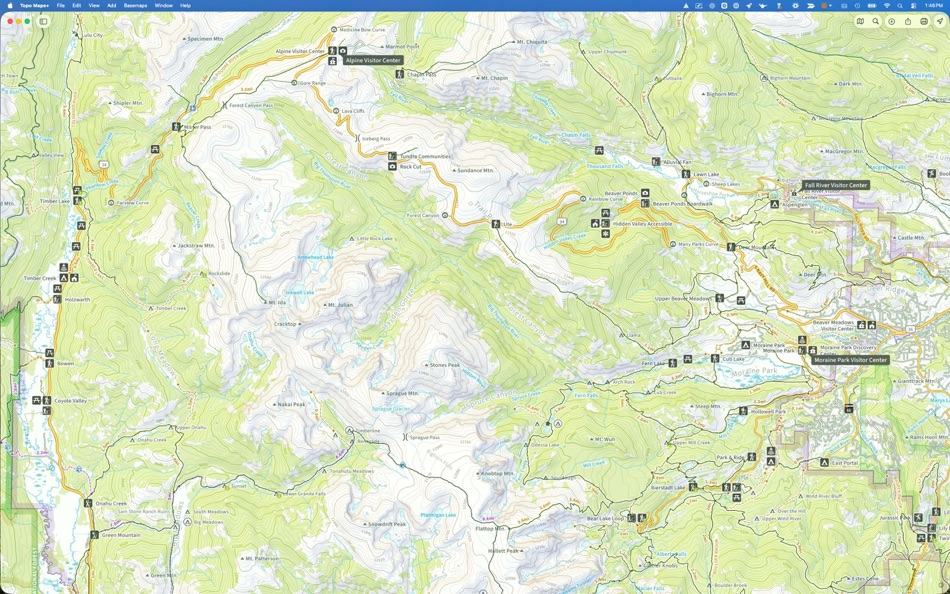
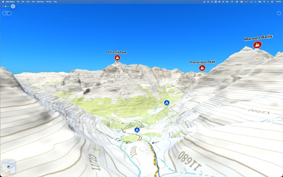
Take advantage of the larger screen for planning your backpacking trips then sync your trip details over to your iOS device and head out into the backcountry!
‣‣ PLANNING TOOLS
‣ Compare maps
‣ Combine overlays to customize your map view
‣ Smart route-building tools
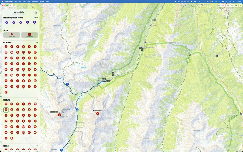
‣ Unlimited waypoints
‣ Print, email or share custom maps and routes
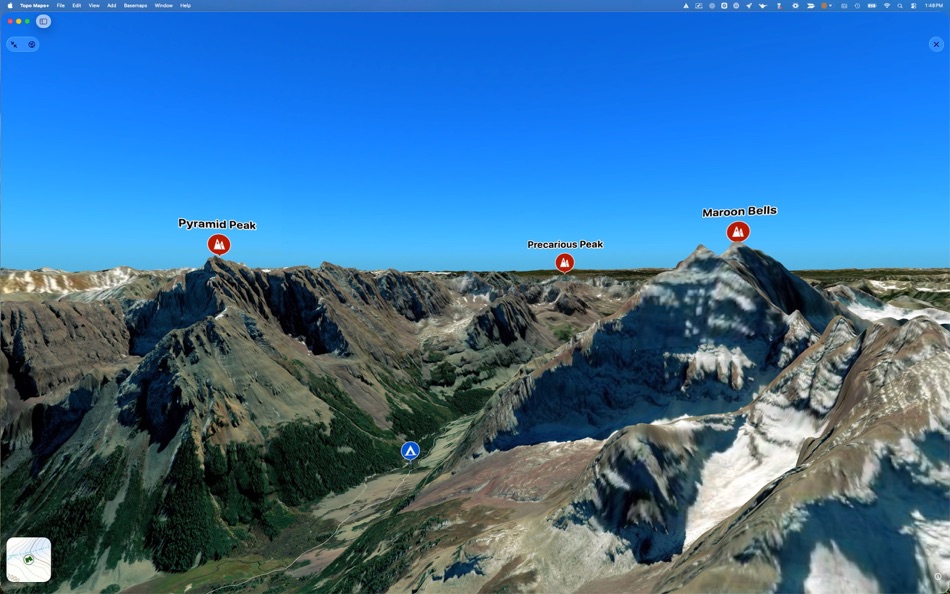
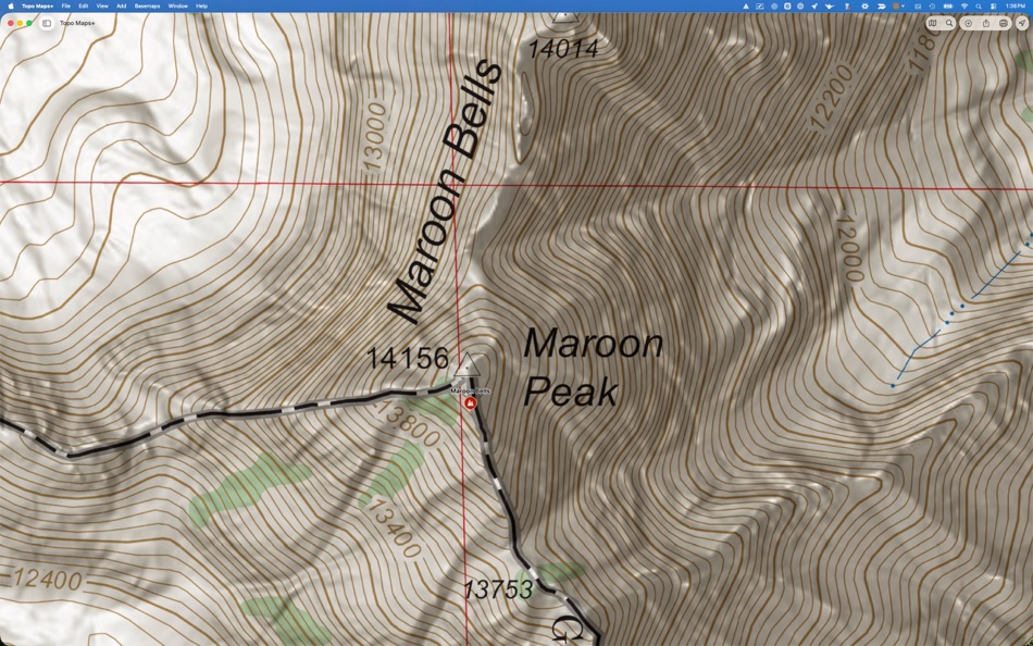
‣‣ TRUSTWORTHY MAPS
From the Gold Standard of traditional USGS, the backcountry features of the US Forest Service, Satellite Imagery, Land Use, Land Cover, the incredible Natural Atlas, NOAA Marine Maps, Canada’s NRCAN/GEOBC, New Zealand Topo Maps from LINZ.
To amazing worldwide maps from ESRI’s ArcGIS including Topo, Street, and Satellite!
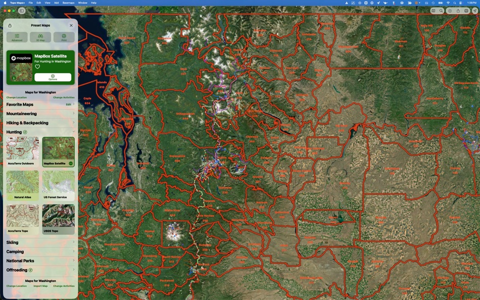
Enhance your maps with custom overlays like:
‣ Worldwide Elevation Heat map - custom color the map based on elevations
‣ US Slope Map - custom shade the map with colors based on slope degrees
‣ Hill Shading
With the iOS companion app you can also have:
‣‣ ON-TRAIL TOOLS (Offline)
‣ View your current location
‣ Record your tracks
‣ Proximity Alerts (notify me when I’m close to a waypoint, trail, or region)
‣ Line of Sight
‣ Progress on Trail
‣ Guide Me to a waypoint
‣ Downloaded elevation data for route-creation on the trail
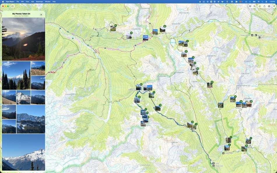
‣ Photo Waypoints (snap a pic and instantly shows on the map)
‣‣ NAVIGATIONAL MINDSET - helpful tips and tricks for keeping you safe in the backcountry!
CLOUD
Sync your routes, trips, subscriptions, and waypoints between all of your iOS devices.
SUBSCRIPTION LEVELS
Free: Sync Data, Elevation Profiles, Waypoints, Export Data, Import Data, Share Data
Annual or Quarterly Pro Subscription: Access to high resolutions maps, premium maps, and advanced features.
SUBSCRIPTION PAYMENT INFORMATION
Topo Maps+ subscriptions will be charged to your Apple ID account at the confirmation of purchase. Subscription automatically renews unless it is canceled at least 24 hours before the end of the current period. Your account will be charged for renewal within 24 hours prior to the end of the current period. Any unused portion of a free trial period, if offered, will be forfeited when the you purchase a subscription. You can manage and cancel your subscriptions by going to your account settings on the App Store after purchase.
Privacy Policy: https://glacierpeak.app/privacy
Terms of Service: https://glacierpeak.app/tos
Ad
Skjermbilder


Prishistorie
-
* Kjøp i appen - Gjeldende pris: Gratis
- Minimum: Gratis
- Maksimalt: Gratis
Spor priser
Tilleggsinformasjon
- Utgivelsesdato:
- Kategori:
macOS Apper›Reiser - OS:
macOS,macOS 14.0 og nyere - Størrelse:
111 Mb - Språk som støttes:
Chinese,English,French,German,Italian,Japanese,Russian - Egnethet:
4+ - Mac App Store Vurdering:
0 - Nettsted:
 https://topomaps.co
Utvikler
- Glacier Peak Studios LLC
- Plattformer: Android Apper (1) iOS Apper (2) macOS Apper (1)
- Lister: 1 + 0
- Poeng: 4 + 9,151 ¡
- Rangeringer: 0
- Kommentarer: 0
- Rabatter: 0
- Videoer: 0
- RSS: Abonner


Rangeringer (0)
0 ☹️
Kommentarer (0)
Vær den første til å kommentere 🌟
«Topo Maps+». Plattform: macOS. Kategori: Reiser. Utvikler: «Glacier Peak Studios LLC». Første utgivelse: . Siste oppdatering: . Gjeldende pris: gratis. Denne tittelen har ennå ikke mottatt vurderinger eller anmeldelser på AppAgg. Lister: offentlige 1, private 0. Sporede punkter: bekreftede 4, indirekte 0. Tilgjengelige språk: Chinese, English, French, German, Italian, Japanese, Russian. AppAgg sporer prishistorikk, rangeringer og tilbakemeldinger fra brukere for «Topo Maps+». Følg fremtidige rabatter og oppdateringer via RSS. AppAgg er ikke vert for applikasjoner eller distribuerer programvare. Alle varemerker, logoer og skjermbilder tilhører deres respektive eiere.
- 🌟 Dele
- Mac App Store
Lignende
-
- Cartograph Maps 2
- macOS Apper: Reiser Av: Harald Meyer
- $8.99
- Lister: 0 0 0
- Poeng: 0 Versjon: 2.7.4 The Cartograph app views Mapsforge offline vector maps, offline raster maps, and online/WMS maps. It supports tracking, route search, overlays, hillshading, reliefs, track drawing, and ⥯
-
- Explore - for Google Maps
- macOS Apper: Reiser Av: Lucian Boiangiu
- $3.99
- Lister: 0 0 0
- Poeng: 0 Versjon: 1.0 Plan Trips and save Locations and Navigation Routes with a click and access them anytime. Fully customize your vacation plan, locations, hotels, expenses and many more! Access Google ... ⥯
-
- inRoute – Intelligent Routing
- macOS Apper: Reiser Av: Carob Apps, LLC
- * Gratis
- Lister: 1 + 1 0 0
- Poeng: 5 Versjon: 8.8.7 Plan optimal routes or chart your own course using weather, elevation, curves and more. Then navigate safely with voice-guided, turn-by-turn directions that automatically check your ... ⥯
-
- Mappa Mini
- macOS Apper: Reiser Av: Lucas Raggers
- Gratis
- Lister: 0 + 1 0 0
- Poeng: 6 Versjon: 1.5.1 Mappa Mini lets you quickly search for locations and open them in your preferred map service Apple Maps, Google Maps, OpenStreetMap, Waze, Here WeGo right from your Mac s menu bar, ... ⥯
-
- Garmin BaseCamp
- macOS Apper: Reiser Av: Garmin
- Gratis
- Lister: 0 0 5 (1)
- Poeng: 0 Versjon: 4.8.11 Garmin® BaseCamp® provides an interface for viewing Garmin map products and managing geographic data. With BaseCamp, you can perform the following tasks: Transfer data to and from your ⥯
-
- i-Boating : Marine Navigation
- macOS Apper: Reiser Av: Bist LLC
- * Gratis
- Lister: 1 0 0
- Poeng: 1 Versjon: 154.0.0 This App offers access to Marine Charts for USA,Canada,UK/Ireland,Germany,Netherlands/Holland & Europe Rivers (Danube,Drava,Rhein etc). Coverage includes NOAA marine vector ... ⥯
-
- Pin Drop - Bookmark Places
- macOS Apper: Reiser Av: Salucia Ltd
- Gratis
- Lister: 0 0 0
- Poeng: 2 Versjon: 2.0.0 Quickly and easily save places you want to remember from any website with Pin Drop. - Save places from Google Maps and Apple Maps - Detect places from any website and save to your Pin ... ⥯
-
- Avenue GPX Viewer
- macOS Apper: Reiser Av: Vincent Neo
- Gratis
- Lister: 0 0 0
- Poeng: 3 Versjon: 1.6.0 Need to view some .GPX files? Look here! Avenue GPX Viewer is a simple and easy-to-use viewer that allows you to view GPS traces recorded in the GPX 1.1 file format, with no ads, no in ⥯
-
- Road Trip Planner
- macOS Apper: Reiser Av: Kyle Modesitt
- $3.99
- Lister: 0 0 0
- Poeng: 0 Versjon: 4.6.08 Place pins on a worldwide map for each location you want to visit, then see your route. Enter trip details for each location and create a complete trip itinerary. You can DEMO this app ⥯
-
- iCaching
- macOS Apper: Reiser Av: Marius de Reus
- $11.99
- Lister: 0 + 2 0 0
- Poeng: 0 Versjon: 11.1.2 iCaching is an indispensable tool for geocachers with a Mac. Import, organize, manage, explore and export your geocaches with iCaching. A native, fast Mac App! Import Import GPX- or ... ⥯
-
- myTracks
- macOS Apper: Reiser Av: Dirk Stichling
- $17.99
- Lister: 0 + 1 0 0
- Poeng: 1 Versjon: 4.4.7 myTracks is the swiss-army knife for organizing your GPS tracks. They can be loaded from a broad range of devices and organized in a library comfortably. Once imported you can drag & ... ⥯
-
- Arrival - GPS driving assistant: ETA, travel time and directions to your favorite locations
- macOS Apper: Reiser Av: Jan-Niklas FREUNDT
- $3.99
- Lister: 0 0 0
- Poeng: 0 Versjon: 1.0 Arrival is on Sale! Save 50%! Arrival shows you travel times and helps you to find the best and fastest routes to your favorite locations. You can get turn-by-turn directions in a ... ⥯
-
- Nav-on-Bike
- macOS Apper: Reiser Av: Peter Gerber
- Gratis
- Lister: 0 0 0
- Poeng: 1 Versjon: 3.1.1 Plan your motorcycle tours quickly, precisely, and flexibly on your Mac. Nav-on-Bike is a modern alternative to Garmin BaseCamp, designed for better performance, intuitive usability, ... ⥯
-
- TrafficCamNZ
- macOS Apper: Reiser Av: David Wilson
- $1.99
- Lister: 0 0 0
- Poeng: 0 Versjon: 1.5.0 TrafficCamNZ displays internet accessible pictures of Traffic Cameras from around the world. It can be used for any images, weather maps, surf pictures, even office security. Images ... ⥯