Saved
Choose the name that will be shown in your Saved menu.
Done!
| Developer: | Rocket Splash Games (33) | ||
| Price: | $6.99 | ||
| Score: | 3,880 Silver | ||
| Rankings: | 0 | ||
| Comments: | 0 Add a comment | ||
| Lists: | 1 + 0 | ||
| Points: | 0 + 1 (1.0) ¡ | ||
| +1 Points | |||
Description
")
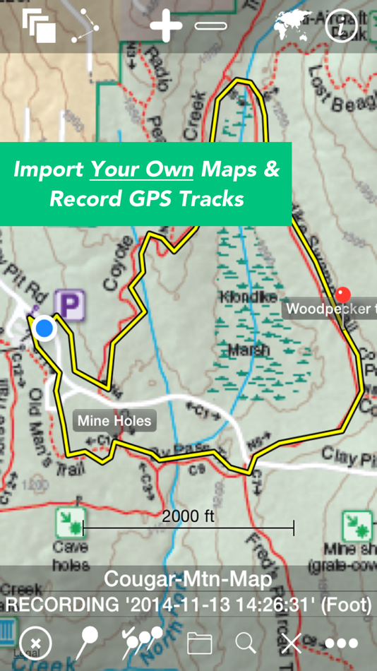
* IMPORT AND VIEW YOUR OWN MAPS and GPS tracks on your device, and record tracks and detailed WAYPOINT notes. MAPS n TRAX excels in rugged "off the grid" professional, academic, and recreational activity on land, sea or air!
* GREAT SUPPORT! MAPS n TRAX is well-supported with a detailed online User Guide (http://rallyto.com/maps-n-trax/maps-n-trax-user-guide/) and responsive, personal email support.
With MAPS n TRAX you can:
• Import and view your favorite maps (see supported file formats below*).
• View your current GPS location on your imported map.
• Record GPS tracks.
• Record waypoint details including photographs and field notes.
• View maps and tracks superimposed on familiar online background maps.
• Import GPS tracks from other sources or export your track records.
• Easily store, organize and access multiple maps and track files.
Use MAPS n TRAX to view specialized map files, topographic maps, or digital map image files and gps tracks on your iOS device. You can even import scanned paper maps or photos of maps!
Even when far beyond the reach of cellular data or WIFI networks, with MAPS n TRAX you can view your own downloaded maps and use the GPS navigational features of your iOS device.
MAPS n TRAX has numerous professional applications. Our customers use the app to support forest fire fighting operations; environmental and biological field research; search and rescue; petroleum and mining; real estate; geo-truthing; flying; sailing; and, academic research. The off-the-grid functionality and waypoint recording features provide a powerful mobile toolset.
MAPS n TRAX is also ideal for a wide range of outdoor recreational including: bushwalking, hiking, trekking, bird watching, treasure hunting, prospecting, camping, bicycle touring, hunting, fishing, snowmobiling, dogsledding, 4-wheel drive off-road motoring, geocaching, orienteering, randonneuring, mountain biking, skiing (downhill, backcountry, Nordic), and squatching, among others.
Many publicly available maps can be imported into MAPS n TRAX. In addition the app is well suited for applications that require specialist maps with details that are customized or are not widely available, such as highly detailed topographic maps obtained from your government mapping authority or specialized maps produced with GIS tools.
Details:
• Converts and displays a wide range of map and image file types including * PNG, JPEG, TIFF, GIFF, ESRI Shapefiles, ESRI File Geodatabase and Open Street Map (PBF & XML) and geo-referenced image formats such as GeoTIFF. (Note: .ozf2 & .ozfx3 files are NOT supported). See the User Guide for more information about working with these files.
• Imports and exports tracks in GPX and KML formats.
• Compatible with raster and vector map file types and projections used in commercial and open source Geographic Information Systems (GIS) software tools including ARCGIS and OpenStreetMaps.
• Automatically align geo-referenced image files or manually calibrate non-geo-referenced ones.
• Can display large maps and can join several consecutive large maps into a single huge map. The map size is limited only by the iPhone or iPad's storage capacity.
• Imported maps of different scales can be viewed simultaneously, adjacent to or overlapping each other.
• Multiple tracks can be displayed on maps simultaneously and tracks with named waypoints can be searched like a directory or gazetteer.
We recommend that you review our website www.rocketsplashgames.com/mapsntrax/support/ and the online User Guide to be sure that MAPS n TRAX suits your requirements. The User Guide section on Preparing Maps describes the process to prepare a plain image file for use as a location-calibrated and mobile-optimized map image.
Continued use of the GPS running in the background can dramatically reduce battery life on the iPhone or iPad.
Screenshots


Ad
Price History
- Current price: $6.99
- Minimum: $6.99
- Maximum: $6.99
Track prices
AppAgg Score
3,880
Estimated AppAgg Score for
Maps n Trax - Offline Maps, GPS Tracks & Waypoints
3,880 Silver
Higher scores usually mean stronger signals on AppAgg.
Based on: popularity · ratings · freshness · deals · store data · community signals
Recalculated daily using fresh AppAgg data.
Short URL: Copied!
What's new
- Version: 6.2.16
- Last Updated:
- This app has been updated by Apple to display the Apple Watch app icon.
-Updated help and support links and guides
Additional Information
- Release Date:
- Category:
iOS Apps›Navigation - OS:
Apple Watch,iPad,iPhone,iOS 8.0 and up - Size:
37 Mb - Supported Languages:
English - Content Rating:
4+ - App Store Rating:
1.0(1)
Developer
Lists (1)
- Maps n Trax - Offline Maps, GPS Tracks & Waypoints

Points (0)
0
Rankings (0)
0
Comments (0)
Be the first to comment
Summary
- Share
- App Store
«Maps n Trax - Offline Maps, GPS Tracks & Waypoints» is a Navigation app for iOS, developed by «Rocket Splash Games». It was first released on and last updated on . The lowest historical price was $6.99, and the highest was $6.99. This app has not yet received any ratings on AppAgg. It has been added to 1 public lists and 0 private lists created by users. On App Store, the current store rating is 1.0 based on 1 votes. Available languages: English. AppAgg continuously tracks the price history, ratings, and user feedback for «Maps n Trax - Offline Maps, GPS Tracks & Waypoints». AppAgg does not host applications or distribute software. All trademarks, logos and screenshots belong to their respective owners. Subscribe to this app or follow its RSS feed to get notified about future deals or updates.
Similar
-
- Maps Anywhere: Offline GPS
- iOS Apps: Navigation By: Ali Mert TUFEKCI
- Free
- Lists: 0 0 0
- Points: 5 + 3 10K · Gold Version: 1.0.0.8 SecureTrek Maps Anywhere - Stay Oriented in the Wild Every year, thousands of people get lost while trekking or exploring the outdoors due to poor visibility, disorientation, or losing
-
- Offline GPS Converter
- iOS Apps: Navigation By: Artur Pahasian
- Free
- Lists: 0 0 0
- Points: 0 + 1 570 · Bronze Version: 1.0 Offline GPS Converter helps you instantly convert geographic coordinates no internet needed. Whether you're a field worker, radio operator, or outdoor enthusiast, this app delivers ...
-
- GPS Tracks
- iOS Apps: Navigation By: David Morneault
- Free
- Lists: 5 + 2 0 0
- Points: 10 + 17,121 48K · Legend Version: 5.1.1 "One of the better GPS apps for sporting enthusiasts for the iPhone..." - Bryan Wolfe, AppAdvice.com Do you want to track your hiking, biking, walking, running? Do you want to track ...
-
- GPS Tracks Pro
- iOS Apps: Navigation By: Ekta Undhad
- * Free
- Lists: 0 0 0
- Points: 0 + 0 950 · Silver Version: 1.4 Track your routes, explore maps offline, and save every journey with ease. Perfect for outdoor lovers who want accurate tracking and simple navigation anytime, anywhere. Measure land ...
-
- Offline GPS Tracker & Compass
- iOS Apps: Navigation By: Gijsbertus Lamers
- $17.99
- Lists: 0 0 0
- Points: 0 + 0 840 · Silver Version: 3.9 Offline GPS Tracker & Compass Reliable offline navigation, route recording, and elevation tracking with no account and no subscription. Offline GPS Tracker & Compass is designed for ...
-
- Offline GPS Navigation
- iOS Apps: Navigation By: Karta
- * Free
- Lists: 0 0 0
- Points: 0 + 3 7K · Gold Version: 2.51.03 Navigate in Sweden and download any map from all over the world! This special Swedish version offers free traffic and Speed Radars information with lifetime updates. All maps are free ...
-
- Maps Tracking Offline Pro
- iOS Apps: Navigation By: Ozariya Samirbhai
- Free
- Lists: 0 0 0
- Points: 0 + 0 770 · Silver Version: 1.1 Discover the world like never before with Maps Tracking Offline Pro your smart travel companion combining immersive 360° place views, intelligent route planning, and trip management in
-
- GPS Tracks - MyGPSLog
- iOS Apps: Navigation By: Richard Vetter
- Free
- Lists: 0 0 0
- Points: 0 + 2 590 · Bronze Version: 1.0.5 Designed for the modern adventurer, this GPS logging app combines simplicity with complete privacy. Capture your path as you explore trails, roads, or new destinations with just a tap.
-
- GPS-Platform
- iOS Apps: Navigation By: GPS Plateform Ltd
- Free
- Lists: 0 0 0
- Points: 0 + 0 790 · Silver Version: 1.2 This is mobile client of GPS-Platform tracking application. To use the application, you need a personal account or access to hosted software. Demo Account Credentials: Username: demo ...
-
- GPS TechTracker Pro
- iOS Apps: Navigation By: GPS California SA de CV
- Free
- Lists: 1 0 0
- Points: 1 + 0 1K · Silver Version: 2.18.11 GPS TechTracker provides you with a powerful tool with real-time capability that includes detailed professional reports, reproduction of the routes used in each trip, multiple alerts, ...
-
- GPS ASSIST: Vehicle Tracking
- iOS Apps: Navigation By: GPS ASSIST LTD
- Free
- Lists: 0 0 0
- Points: 0 + 0 580 · Bronze Version: 1.1 GPS ASSIST - Smarter Tracking. Requires a GPS ASSIST device to use this app. Take full control of your vehicle s security with GPS ASSIST, the companion app designed to work ...
-
- GPS OF GEORGIA
- iOS Apps: Navigation By: GPS OF GEORGIA
- Free
- Lists: 0 0 0
- Points: 0 + 2 590 · Bronze Version: 1.0.1 It is possible to connect up to 1600 types of SUV devices on our platform, as well as we prepare SUV trackers in Georgia.
-
- Desert Maps: Navigator Offline
- iOS Apps: Navigation By: Rachid Smet
- Free
- Lists: 0 0 0
- Points: 0 + 379 25K · Platinum Version: 8.5 Desert Maps Your Ideal Companion for Desert and Remote Area Exploration The new and improved version of the Desert Maps app is the perfect guide for all lovers of outdoor adventures, ...
-
- Guru Maps Pro - Offline Nav
- iOS Apps: Navigation By: Evgen Bodunov
- $89.99
- Lists: 6 + 3 0 0
- Points: 6 + 977 44K · Legend Version: 6.1.2 Explore the world offline with Guru Maps Pro detailed maps, turn-by-turn navigation, and GPS track recording that keep working when you have no signal. Download maps once and use them ...