| Разработчик: | BT FINANCE s.r.o. (1) | ||
| Цена: | * Бесплатно | ||
| Рейтинги: | 0 | ||
| Отзывы: | 0 Написать отзыв | ||
| Списки: | 0 + 0 | ||
| Очки: | 0 + 2,183 ¡ | ||
| Очки + 1 | |||
Описание
")
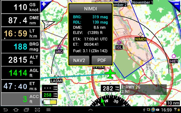
FLY is FUN simulates ILS approach, VOR, NDB, DME, Marker beacons, RNAV navigation and Marker beacons warnings, without ILS/VOR/NDB/RNAV equipment on board.
You can test FLY is FUN for free during few days. At the end of the trial period, pilot is invited to subscribe and pay an annual fees. Doing it, he get the right of using the application "as it is" and contribute to development effort.
FLY is FUN allows:
- Creating and modifying routes using "drag and drop", "rubber band"
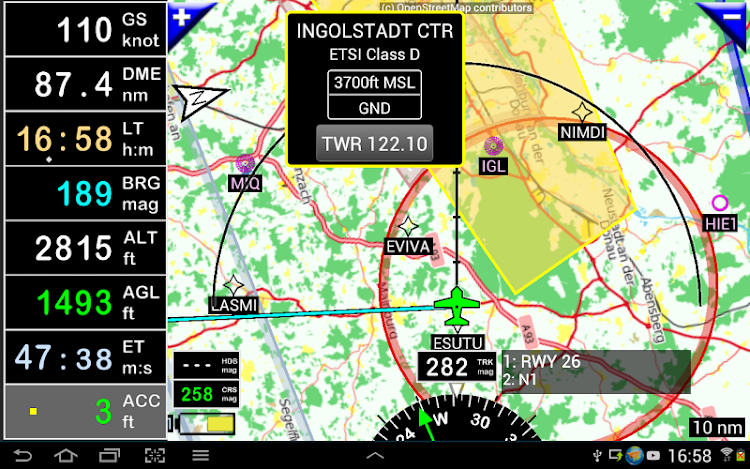
- Getting warnings, alarms and radio info before entering controlled or special use airspaces, approaching points
- Performing route planning, evaluating distance, time and fuel consumption (depending on wind and aircraft characteristics)
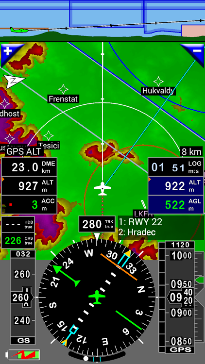
- Displaying route, bearing, trace on moving map
- Visualizing airspace
- Getting dynamic terrain map (colors depending of elevation above ground level)
- STRATUX support
- Creating and exporting Flight Plan
- Creating and exporting Flight log
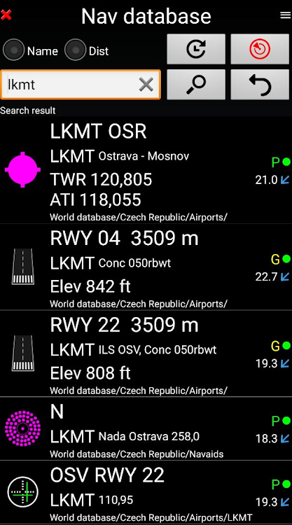
- Creating, importing or exporting routes, waypoints, RWY, airspace (Garmin .gpx, .kml, txt, OpenAir)
- Recording the flight and playing it back with Google Earth
- Sunset / Sunrise
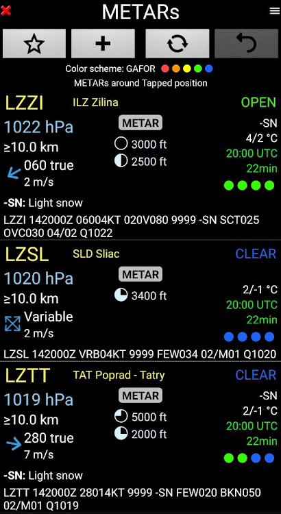
- Getting weather forecast along the route
- Rainfall radar
- Wind displaying
- Calculating distance between 2 points on the map
- VACs
- Notepad
…
All main screens (5 portrait and 5 landscape could easily be customized. Pilot can choose from around 100 values to display. Example:
- Altitude GPS or barometric
- Ground speed
- Bearing
- Vertical speed
- DME to next point / destination
- Estimated time to next point / destination
- Time since departure
- Stop watch
…
Displayed information could be customized too depending of users preferences (VFR, IFR or both) and zoom level. The more you zoom IN, the more detail, information, waypoints,.. you see
Logbook
The integrated logbook, allows recording:
- Duration since departure time
- Departure and arrival time
- Departure and arrival airport
- Flight track (it is possible to export it as .kml or .gpx and to replay it)
- Used aircraft
- Pilot(s) and copilots in charge
- Distance, average speed, maximum speed
…
Navigation data available from open source database are updated according AIRAC cycles.
Charts and elevation dta
Free charts and elevation data are available for most of countries and could be imported directly via the application store.
Other charts could be created and imported by the pilot itself or made on request available as commercial service.
Pilots could select the most appropriate charts: free open source charts as well as commercial charts as ICAO, Cartabossy, SkyVector, FAA sectional and terminal charts…
VACs and PDF files
VAC and AIP infos are available for more than 50 countries
User can easily attach your own PDF files.
Usage of external GPS connected via Bluetooth is possible
User guide: http://www.funair.cz/downloads/manuals/flyisfun.pdf
If you have any suggestion to improve this application or you find some bug please visit www.flyisfun.com
Use this application for VFR FLYING ONLY!!! We are not responsible for any use of this application.
Скриншоты


Видео
Что нового
- Версия: 33.22
- Обновлено:
- - Better choosing VHF frequencies for traffic patterns
Цена
-
*Встроенные покупки - Сегодня: Бесплатно
- Минимум: Бесплатно
- Максимум: Бесплатно
Отслеживайте цены
Разработчик
- BT FINANCE s.r.o.
- Платформы: Android Приложения (1)
- Списки: 0 + 0
- Очки: 0 + 2,183 ¡
- Рейтинги: 0
- Отзывы: 0
- Скидки: 0
- Видео: 1
- RSS: Подписаться
Очки
Не найдено ☹️
Рейтинги
Не найдено ☹️
Списки
Не найдено ☹️
Отзывы
Ваш отзыв будет первым!
Дополнительная информация
- Категория:
Android Приложения›Карты и навигация - Операционные системы:
Android 5.0 и выше - Размер:
21 Mb - Возрастные ограничения:
Everyone - Google Play Рейтинг:
4.1(2,183) - Обновлено:
- Дата выпуска:
Контакты
Вам также могут понравиться
-
- Navigation Wear
- Android Приложения: Карты и навигация От: Navigation Wear
- * Бесплатно
- Списки: 0 + 0 Рейтинги: 0 Отзывы: 0
- Очки: 1 + 4,770 Версия: New Navigation Wear app displays navigation directions from your smartphone on your smartwatch. Navigation Wear app starts automatically on your smart watch after launching maps turn by ...
-
- Navigation for watch
- Android Приложения: Карты и навигация От: Navigation Watch
- * Бесплатно
- Списки: 0 + 0 Рейтинги: 0 Отзывы: 0
- Очки: 0 + 374 Версия: 1.2.1 Navigation for watch shows navigation directions from Google Maps navigation on your Samsung watch and transforms them into a beautiful piece of art using hand crafted styles. ...
-
- Maps, GPS Navigation, route
- Android Приложения: Карты и навигация От: Navigation Apps Tech
- * Бесплатно
- Списки: 0 + 0 Рейтинги: 0 Отзывы: 0
- Очки: 0 + 927 Версия: 2.0.15 Maps, GPS Navigation, voice navigation, Directions is latest voice GPS and driving app application offers the alternative routes plus the shortest routes for your destination just like
-
- Truck GPS Route Navigation
- Android Приложения: Карты и навигация От: Offline Maps & Navigation
- * Бесплатно
- Списки: 0 + 0 Рейтинги: 0 Отзывы: 0
- Очки: 0 + 310 Версия: 1.15 The new GPS app especially designed for truck drivers, a user friendly and simple truck GPS navigation route navigation. A truck specific navigation system is designed for safe and ...
-
- Navigation Watch
- Android Приложения: Карты и навигация От: Prog Apps
- * Бесплатно
- Списки: 0 + 0 Рейтинги: 0 Отзывы: 0
- Очки: 0 + 478 Версия: New After installation just launch the app on your phone and grant the requested permission. Supported are Fitbit, Garmin, Huawei and Wear OS watches. Every time when you want to use it: ...
-
- Navigation by Verizon Connect
- Android Приложения: Карты и навигация От: Verizon Connect
- Бесплатно
- Списки: 0 + 0 Рейтинги: 0 Отзывы: 0
- Очки: 0 + 108 Версия: 6.27.1 Navigation Global Edition is a commercial navigation app specifically tailored for professional drivers who need accurate, truck-legal, turn-by-turn directions. The app uses live and ...
-
- Aviation Crewrest Calculator
- Android Приложения: Карты и навигация От: Steve Dexter
- Бесплатно
- Списки: 0 + 0 Рейтинги: 0 Отзывы: 0
- Очки: 0 + 59 Версия: 1.4 This Tool helps the long haul crews to calculate the individual rest time.
-
- Air Navigation Pro
- Android Приложения: Карты и навигация От: Air Navigation SA
- * Бесплатно
- Списки: 0 + 1 Рейтинги: 0 Отзывы: 0
- Очки: 0 + 4,361 Версия: 8.3.361.403130854 Discover our flight planning & real-time navigation app for free for 28 days! - Everything you need to fly around the world - Plan your flight in a few minutes - Fly relaxed with ...
-
- Live Earth Maps & Navigation
- Android Приложения: Карты и навигация От: live street view maps and navigation
- * * Бесплатно
- Списки: 0 + 0 Рейтинги: 0 Отзывы: 0
- Очки: 0 + 528 Версия: 1.5.6 Live Earth Map & Navigation uses live street map to bring your location on panorama & gives street view locations and a clear picture of traffic in your area with global earth. Street ...
-
- GPS Maps Location & Navigation
- Android Приложения: Карты и навигация От: Pixamattic Inc -Live Earth Cameras, GPS Navigation
- * * Бесплатно
- Списки: 0 + 0 Рейтинги: 0 Отзывы: 0
- Очки: 0 + 3,549 Версия: 1.17 GPS Maps Location & Voice Navigation Amazing Features: * Easy to use GPS Voice Navigation * Perfect GPS Navigation with precise directions * Fast GPS Route Planner can plan the ...
-
- Navigation Pro: Maps on Watch
- Android Приложения: Карты и навигация От: Smartwatch Studios
- $2.99
- Списки: 0 + 1 Рейтинги: 0 Отзывы: 0
- Очки: 1 + 11,418 Версия: New Displays Google Navigation instructions from the phone on your Samsung watch. Great for driving, cycling and public transport. Features autostart with navigation, voice output, ...
-
- Navigation, GPS Route finder
- Android Приложения: Карты и навигация От: Alexo Apps
- * Бесплатно
- Списки: 0 + 0 Рейтинги: 0 Отзывы: 0
- Очки: 0 + 3,127 Версия: 7.7 GPS Route Finder use GPS & Network to get your position on Earth Map, Helps you Navigate Freely on satellite maps and get you required directions with traffic updates. Route Finder ...
-
- Karta GPS France Navigation
- Android Приложения: Карты и навигация От: Karta Software Technologies - GPS Navigation
- * * Бесплатно
- Списки: 0 + 0 Рейтинги: 0 Отзывы: 0
- Очки: 0 + 115 Версия: 2.45.02 The most customizable GPS Navigation app in the world! Download France s map or any other country in the world, customize your GPS Navigation experience with a funny voice and navigate
-
- GPS Brasil Offline Navigation
- Android Приложения: Карты и навигация От: NDrive Navigation Systems, SA
- * * Бесплатно
- Списки: 0 + 0 Рейтинги: 0 Отзывы: 0
- Очки: 0 + 143,148 Версия: 2.45.02 More than 2 MILLION downloads in Brazil! GPS Brasil is the GPS navigation app developed by NDrive, that guides you wherever you want, easily and quickly. This app is FREE and includes ...
Вам также могут понравиться
- Android Приложения
- Новые Android Приложения
- Карты и навигация Android Приложения : Новые
- Видео Android Приложения
- Лучшие Android Приложения
- Карты и навигация Android Приложения : Лучшие
- Скидки Android Приложения
- Карты и навигация Android Приложения : Скидки
- Рейтинги Android Приложения
- Отзывы Android Приложения
- Списки Android Приложения
- Очки Android Приложения