| ผู้พัฒนา: | FLYTOMAP INC (337) | ||
| ราคา: | $4.99 | ||
| การจัดอันดับ: | 0 | ||
| ความเห็น: | 0 เขียนความเห็น | ||
| รายการ: | 0 + 0 | ||
| แต้มแล: | 0 + 0 ¡ | ||
| แต้มแล + 1 | |||
คำอธิบาย
")
Featured on the Deck
Featured on Geomedia
Worldwide Marine and Outdoor Maps available when connected, thanks to viewer.flytomap.com
Worldwide Satellite images overlay on charts
Worldwide Terrain features overlay on charts, thanks to Open Street Map, Open Cycle Map,Earth,topo maps by ESRI
Now with NOAA raster charts seamless with continuous updates from the official Government server
Now with ActiveCaptain - Worldwide boaters community * 200.000 + Captains
Use to Explore:
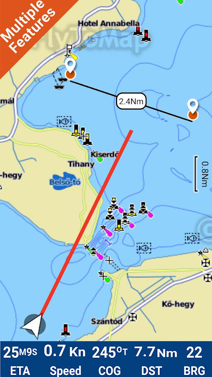
√ Latitudes and Longitudes to go to your favorite places
√ Search your Favorite points directly
√ Zoom, Rotate and Pan fast just by a finger touch
√ Local Marine Weather forecast at a tap
√ Route with unlimited waypoints
√ With Head Up and Course Up feature
√ Geocompass
√ Navigate and see your GPS position on the map
√ Heading Vector Towards the direction movement
√ Distance Measurement Tool to easily calculate the distance from one location to another
√ Insert the target and destination and see in real time your speed, distance and bearing
√ background mode - Flytomap works in background as well, you can swap with another app and receive/make calls send sms while panning and zooming.
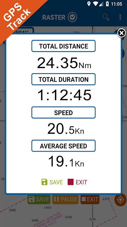
√ Unlimited Tracks share via email, visible on Google, Flytomap Viewer, KMZ format - Store your track without the need of cellular data or mobile signal
√ KMZ KML from / to GPX Converter
√ Optimized battery usage
√ ActiveCaptain
• View and contribute to the best boaters community available in the world
• Continuous update of all info (including reviews from the deck) about :
• Marinas
• Anchorages
• Hazards
• Local Knowledge
√ And so much more to come - It’s the only app you will ever need! Our charts are installed on: GARMIN NAVICO LOWRANCE B&G NORTHSTAR EAGLE SIMRAD
Follow us:
▶Twitter @flytomap
▶Web Site flytomap.com
▶Web App viewer.flytomap.com
▶Facebook facebook.com/flytomap
The entire cartography of Italy Lakes is included in this application
Flytomap is committed to constant improvement, this App is developed with the help of professional boaters to get the best experience on the sea, we listen to our users and systematically add the most requested features.
Thank you for the feedback!
Additional info about Flytomap products
FLYTOMAP LAKE MAPS:
We offer high quality lake maps with detailed information and important features compressed to assure the larger coverage in USA region. Lake maps contain most important DNR lakes with detailed ‘Depth Contours, Boat Ramps, Fishing spots etc. Also includes Trails, Roads and Railways information.
WATER MAPS (Marine):
Water map navigator is the new ‘Marine Navigator for all mobile devices contains embedded Electronic Nautical Charts (ENC) from NOAA compressed to a large coverage.You can now download the application and transform your Phone in a chart plotter with best NOAA, ENC S57 cartography; which includes Anchoring areas, Fishing areas,restriction areas, obstructions, rocks, Buoys, Beacons, Lights, Depth contours with Values display on map, Spot Soundings and more. The only marine app’s available in the market with such huge information. Every effort is made to be as accurate as possible when presenting information for every destination.
TRAVEL MAPS:
These Maps treat you mostly with information of both Marine and terrain correspondingly. These are the most preferable Maps to travel especially for fascinating recreational voyages, map focus the best Beach spots along the Coast line, Major ports, Sailing, Fishing, Picnic areas, Parks, Hiking, Biking, Clubs, restaurants,Famous Hotels, Museums, Shopping areas, and much more. Introducing guide in map navigator for easy references, you can use it without any Active Internet connection!
“We work to delight your moments”
! Enjoy great Journeys!
ภาพหน้าจอ


มีอะไรใหม่
- เวอร์ชัน: 4.4.3.7
- อัปเดต:
- User interface improved
ราคา
- วันนี้: $4.99
- ต่ำสุด: $4.99
- มากที่สุด: $4.99
ติดตามราคา
ผู้พัฒนา
- FLYTOMAP INC
- แพลตฟอร์ม: Android แอป (337)
- รายการ: 0 + 0
- แต้มแล: 1 + 745 ¡
- การจัดอันดับ: 0
- ความเห็น: 0
- ลดราคา: 0
- วิดีโอ: 0
- RSS: ติดตาม
แต้มแล
ไม่พบ ☹️
การจัดอันดับ
ไม่พบ ☹️
รายการ
ไม่พบ ☹️
ความเห็น
แสดงรีวิวเป็นคนแรกเลย!
ข้อมูลเพิ่มเติม
- หมวดหมู่:
Android แอป›แผนที่และการนำทาง - ระบบปฏิบัติการ:
Android 5.0 และสูงกว่า - ขนาด:
59 Mb - การจัดประเภทเนื้อหา:
Everyone - Google Play คะแนนโดย:
0 - อัปเดต:
- วันที่วางจำหน่าย:
รายชื่อติดต่อ
- X: flytomap
- Facebook: flytomap
- เว็บไซท์:
 http://flytomap.com
คุณอาจชอบ
-
- Maine Lakes Gps Map Navigator
- Android แอป: แผนที่และการนำทาง โดย: FLYTOMAP INC
- * $3.99
- รายการ: 0 + 0 การจัดอันดับ: 0 ความเห็น: 0
- แต้มแล: 0 + 0 เวอร์ชัน: 4.4.3.7 Flytomap is a valid and interesting alternative, Featured on the Deck Featured on Geomedia Worldwide Marine and Outdoor Maps available when connected, thanks to viewer.flytomap.com ...
-
- Red Sea GPS Map Navigator
- Android แอป: แผนที่และการนำทาง โดย: FLYTOMAP
- * $3.49
- รายการ: 0 + 0 การจัดอันดับ: 0 ความเห็น: 0
- แต้มแล: 0 + 0 เวอร์ชัน: 4.4.4.4 Flytomap is a valid and interesting alternative, Benetti Yachts Featured on the Deck Featured on Geomedia Worldwide Marine and Outdoor Maps available when connected, thanks to ...
-
- GPS Navigation Live Map Road
- Android แอป: แผนที่และการนำทาง โดย: GPS Map Navigation: English Grammar Learning Apps
- * ฟรี
- รายการ: 0 + 0 การจัดอันดับ: 0 ความเห็น: 0
- แต้มแล: 0 + 0 เวอร์ชัน: 1.3 Explore the whole world by the GPS navigation live map road app. Visit the live satellite view in real-time. 3d earth map app is using the GPS map to display all locations on your ...
-
- GPS Land Field Area Measure
- Android แอป: แผนที่และการนำทาง โดย: GPS Map Camera
- * * ฟรี
- รายการ: 0 + 0 การจัดอันดับ: 0 ความเห็น: 0
- แต้มแล: 0 + 559 เวอร์ชัน: 1.1.6 Are you looking for an easy and convenient way to measure land area? Look no further than the GPS land field area measure app! With this measuring app, you can easily and quickly ...
-
- Gps Voice Map Navigator
- Android แอป: แผนที่และการนำทาง โดย: FORIOX
- * ฟรี
- รายการ: 0 + 0 การจัดอันดับ: 0 ความเห็น: 0
- แต้มแล: 0 + 89 เวอร์ชัน: 1.0.12 If you confused about any route? Don't worry about it. GPS Navigator helps you. If you confused about your journey and route? Don't worry about it. This GPS Voice Map Navigator app ...
-
- GPS Map: Live Satellite View
- Android แอป: แผนที่และการนำทาง โดย: Saima Apps
- * ฟรี
- รายการ: 0 + 0 การจัดอันดับ: 0 ความเห็น: 0
- แต้มแล: 0 + 0 เวอร์ชัน: 2.3 View the world Satellite Map location with GPS Map: Live Satellite View App. Get a realistic view of Street Map View and map on the same screen with zoom-in & zoom-out capability. ...
-
- GPS Map Coordinates Finder
- Android แอป: แผนที่และการนำทาง โดย: Breed Softech
- * * ฟรี
- รายการ: 0 + 0 การจัดอันดับ: 0 ความเห็น: 0
- แต้มแล: 0 + 65 เวอร์ชัน: 1.6 GPS Map Coordinates Finder is a user-friendly app that helps you quickly find your GPS coordinates, as well as the coordinates of any location on earth. This app is perfect for hikers,
-
- GPS Map Driving Directions
- Android แอป: แผนที่และการนำทาง โดย: Andro World Inc.
- * ฟรี
- รายการ: 0 + 0 การจัดอันดับ: 0 ความเห็น: 0
- แต้มแล: 0 + 0 เวอร์ชัน: 1.4 GPS Map Driving Directions & Traffics is a easy and simple maps directions app.Using Voice GPS Map Driving Directions & Traffics, you can find the shortest possible route and ...
-
- Gps map navigation compass
- Android แอป: แผนที่และการนำทาง โดย: BGC Studio
- * * ฟรี
- รายการ: 0 + 0 การจัดอันดับ: 0 ความเห็น: 0
- แต้มแล: 0 + 246 เวอร์ชัน: 1.5.1 GPS map navigation is a tool that uses GPS (Global Positioning System) technology to provide real-time guidance and directions to users. It is commonly accessed through mobile ...
-
- GPS Map Ruler-area measurement
- Android แอป: แผนที่และการนำทาง โดย: Power Star APPS
- * ฟรี
- รายการ: 0 + 0 การจัดอันดับ: 0 ความเห็น: 0
- แต้มแล: 0 + 2,651 เวอร์ชัน: 1.9.3 GPS Map Ruler is a map measurement app, functioning as a virtual map ruler, which can be used for distance measurement between two points, as well as for distance measurement among ...
-
- GPS Speedometer & Odometer APP
- Android แอป: แผนที่และการนำทาง โดย: Tools Village - GPS_Map_Camera, GPS_Speedometer
- * * ฟรี
- รายการ: 0 + 0 การจัดอันดับ: 0 ความเห็น: 0
- แต้มแล: 0 + 0 เวอร์ชัน: New Easy to use speedometer mph tracker GPS Speedometer is a powerful and easy-to-use app. GPS speedometer allows you to track your speed and distance covered while traveling. The ...
-
- GPS Waypoints Navigator | MAPS
- Android แอป: แผนที่และการนำทาง โดย: Disciple Skies Software
- $7.99
- รายการ: 0 + 0 การจัดอันดับ: 0 ความเห็น: 0
- แต้มแล: 1 + 3,728 เวอร์ชัน: 9.30 Convert your phone into a powerful GPS supported by beautiful, easy to read maps and find your way around with confidence in the wilderness, at sea or in the city. GPS Waypoints ...
-
- GPS Map Navigation: 3D Map App
- Android แอป: แผนที่และการนำทาง โดย: Cupncode
- * ฟรี
- รายการ: 0 + 0 การจัดอันดับ: 0 ความเห็น: 0
- แต้มแล: 0 + 0 เวอร์ชัน: New A GPS map navigation app is a digital tool that provides users with a 3d map view of their surroundings and allows them to navigate to different destinations using their smartphone or ...
-
- GPS Compass Navigator
- Android แอป: แผนที่และการนำทาง โดย: Evgeni Ganchev
- * * ฟรี
- รายการ: 0 + 0 การจัดอันดับ: 0 ความเห็น: 0
- แต้มแล: 0 + 5,416 เวอร์ชัน: 2.20.19 When you travel, hiking or fishing, save your position like parked car, shelter or hotel, and navigate back following the guiding arrow. Functions: - Compass - Save current position or