| Kehittäjä: | Asamm Software, s. r. o. (8) | ||
| Hinta: | * $10.99 | ||
| Rankingissa: | 0 | ||
| Arvostelut: | 0 Kirjoita arvostelu | ||
| Listat: | 1 + 1 | ||
| Pisteet: | 2 + 46,156 ¡ | ||
| Pisteet + 1 | |||
Kuvaus
")
Locus Map 3 Classic offers true multi-functionality and flexibility:
• advanced navigation capability, supporting online and offline routing services (external)
• wide choice of premium offline and online maps
• advanced map tools - map overlays, offsets, WMS sources support
• tools for monitoring sports activities - tracking, audio coach, charts, statistics, support of external sensors (GPS, HRM, cadence...)
• worldwide weather forecast 24/7
• sophisticated tools for geocaching • graphic and calculation tools, online/offline logging, support of trackables, Pocket Queries, spoilers…
Map portfolio
Offline maps
• LoMaps - OSM-based vector maps of the whole world. Containing themes for hiking, biking, winter sports, road or city use - three LoMaps are for free
• Maps of renowned cartographic publishers:
• Germany, Austria, Italy - Outdooractive Summer and Winter
• United States - Accuterra trail maps
• Switzerland - SwissTopo
• United Kingdom - Ordnance Survey (eq. to Landranger and Explorer)
• France - IGN topo and satellite
• Spain - CNIG
• Poland - Compass hiking maps
• Czechia, Slovakia - SHOCart
• other countries - PZS Slovenia, IGN Belgium, Cartographia Hungary, etc.
• support of external maps in SQLite, TAR, MBT, GEMF, Orux, or RMAP formats
Online maps
• World - various OSM-based maps
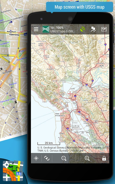
• US - USGS
• Europe - Outdooractive Summer and Winter, IGN France and Belgium, Kapsi.fi, Turistautak, Cartographia, Skoterleder, Statkart, UMP and Osmapa.pl (Poland) and many others
• Asia etc. - GSI (Japan), Visicom (former Soviet countries), Navigasi (Indonesia), NzTopoMaps (New Zealand)...
Most of the online maps can be downloaded for offline use.
WMS maps
• meteorological maps, NASA maps, cadastral maps...
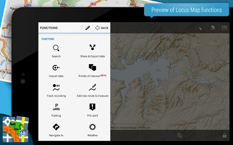
Features:
Navigation and guidance
• turn-by-turn voice navigation with support of online/offline routing services
• beeline guidance to a point (on the map or by compass) or along a route with notifications
Tracks&Routes
• multi-profile track recording
• charts&statistics
• audio coach for efficient workouts
• support of Bluetooth/ANT+ external sensors - HRM, speed/cadence, GPS, NMEA
• route planning and editing tools
• import/export of routes/tracks from/to various formats (KML, KMZ, GPX...) and web services (Strava, Runkeeper, Google Earth, etc...)
• customizable bike computer dashboard
Points
• creating own database - filtering, search, sorting
• import/export in many formats, web services support
• LoPoints - database of OSM POIs
Map tools
• map overlay, calibration, and offsets
• support of various external map formats and coordinate systems
• support of geotagged photos, OSM notes
Search
• addresses online and offline
• LoPoints, GeoNames, GNS, and Wikipedia
Geocaching
• downloading geocaches via Geocaching4Locus add-on
• offline and online logging
• support of waypoints, PocketQuery, trackables, spoilers
• graphic and calculation tools
Live tracking
• private or public sharing/monitoring of location in real-time
Other features and tools
• parking assistant, worldwide weather forecast, QR code generator...
Locus Map 3 Classic is highly customizable. Everything can be set according to the user's needs - the main menu, function panels, dashboards, custom screens... The functionality of the app can be further extended by numerous add-ons - Locus Map Watch, Augmented reality, etc.
This application uses device administrator permission.
Näyttökuvat


Uutta
- Versio: 3.70.9
- Päivitetty:
- Various adjustments and fixes as part of routine maintenance.
Hinta
-
*Sovelluksen sisäiset ostot - Tänään: $10.99
- Vähintään: $7.49
- Enintään: $10.99
Seuraa hintoja
Kehittäjä
- Asamm Software, s. r. o.
- Alustat: Android Sovellukset (8)
- Listat: 1 + 2
- Pisteet: 2 + 107,679 ¡
- Rankingissa: 0
- Arvostelut: 0
- Alennukset: 0
- Videot: 1
- RSS: Tilaa
Pisteet


Rankingissa
Ei löydetty ☹️
Listat
Arvostelut
Ole ensimmäinen tarkistaa!
Lisätietoja
- Luokka:
Android Sovellukset›Kartat ja navigointi - Käyttöjärjestelmä:
Android 5.0 tai uudempi - Koko:
21 Mb - Sisällön ikärajoitus:
Everyone - Google Play Luokitus:
4.4(46,156) - Päivitetty:
- Julkaisupäivämäärä:
Yhteystiedot
- Verkkosivusto:
 https://www.locusmap.app
Saatat myös pitää
-
- Locus Map 4 Outdoor Navigation
- Android Sovellukset: Kartat ja navigointi Tekijänä: Asamm Software, s. r. o.
- * * Ilmainen
- Listat: 0 + 0 Rankingissa: 0 Arvostelut: 0
- Pisteet: 0 + 57,590 Versio: 4.23.1 Discover the joy of exploring the great outdoors with Locus Map, your ultimate navigation app designed for a seamless and enjoyable outdoor experience. Whether you're hiking through ...
-
- Live Earth Map-Street View Map
- Android Sovellukset: Kartat ja navigointi Tekijänä: 8th Genration Apps -Global Earth Map Live apps
- * * Ilmainen
- Listat: 0 + 0 Rankingissa: 0 Arvostelut: 0
- Pisteet: 0 + 10,113 Versio: 4.4 Live Earth Map is an advanced street view app for the person who remains busy in daily life, and can't have enough time to explore the world. Now, you can explore any location around ...
-
- Live Earth Map HD - Live Cam
- Android Sovellukset: Kartat ja navigointi Tekijänä: Globally Live Satellite View Map
- * * Ilmainen
- Listat: 0 + 0 Rankingissa: 0 Arvostelut: 0
- Pisteet: 0 + 48,068 Versio: 2.8.25 Explore the whole world by the live earth map HD live cam app. Visit the live satellite view in real-time. 3d earth map app is using the GPS map to display all locations. With Live ...
-
- Earth Map - 3D World Map
- Android Sovellukset: Kartat ja navigointi Tekijänä: Live Street View Map and Voice Navigation
- * * Ilmainen
- Listat: 0 + 0 Rankingissa: 0 Arvostelut: 0
- Pisteet: 0 + 2,877 Versio: 1.3.9 Use the Earth Map 3D World map app to explore the entire planet. Check out the real-time, live satellite view. The GPS map is used by the 3D Earth Map App to show every place. You may ...
-
- Map Marker
- Android Sovellukset: Kartat ja navigointi Tekijänä: theandroidseb
- * Ilmainen
- Listat: 1 + 0 Rankingissa: 0 Arvostelut: 0
- Pisteet: 0 + 20,947 Versio: 3.7.0-693 This app uses Google Maps and other sources in order to allow you to place markers even without internet connection. If you have any issues with the app, please contact me by email, I ...
-
- Live Street View - Earth Map
- Android Sovellukset: Kartat ja navigointi Tekijänä: Live Satellite View Earth Map - Symmetric Apps
- * Ilmainen
- Listat: 0 + 0 Rankingissa: 0 Arvostelut: 0
- Pisteet: 2 + 34,265 Versio: 2.7.2 Live Street View 360 - Satellite View, Earth Map application is a combination of current Earth Map Satellite and Instant GPS 360 street images. Direct Street View 360 - Satellite View,
-
- Village map full HD 3d
- Android Sovellukset: Kartat ja navigointi Tekijänä: Earth Village Map
- * Ilmainen
- Listat: 0 + 0 Rankingissa: 0 Arvostelut: 0
- Pisteet: 0 + 3,677 Versio: 1.23 All Village Maps - गांव का नक्शा Village Maps will show all villages from India in a hierarchial order, or you can search any place over the world so that you can see the place details
-
- Map Coordinates
- Android Sovellukset: Kartat ja navigointi Tekijänä: Soft Stack Dev
- * * Ilmainen
- Listat: 0 + 0 Rankingissa: 0 Arvostelut: 0
- Pisteet: 0 + 26,987 Versio: 5.6.5 A single tap on the map gives you access to world coordinates. In addition, Map Coordinates offers a full set of tools like distance measurement, current GPS location, history / ...
-
- Map Drive - Radar, Speedometer
- Android Sovellukset: Kartat ja navigointi Tekijänä: Tiki Punch Studio
- * Ilmainen
- Listat: 0 + 0 Rankingissa: 0 Arvostelut: 0
- Pisteet: 0 + 8,042 Versio: 2.8.0 Here is the ultimate navigation app: Map Drive - Radar, Speedometer, HUD! This powerful app is packed with features like fixed speed camera, speed camera detector, head-up display, red
-
- Map of air-raid alert (UA)
- Android Sovellukset: Kartat ja navigointi Tekijänä: Ihor Antoshkin
- * * Ilmainen
- Listat: 0 + 0 Rankingissa: 0 Arvostelut: 0
- Pisteet: 0 + 5,886 Versio: 1.5.1 You can observe on the interactive online map the areas and regions of Ukraine where is a air alarm and sounds a siren just now. (air alarm/alert, map) Receive notifications about the ...
-
- Earth Map Satellite
- Android Sovellukset: Kartat ja navigointi Tekijänä: Mapping Earth Studio
- * * Ilmainen
- Listat: 0 + 0 Rankingissa: 0 Arvostelut: 0
- Pisteet: 0 + 4,237 Versio: 1.7.8 Earth map satellite came with live street view having in built advanced features of living earth map of the world. Live map satellite and satellite world map provide realistic visual ...
-
- Earth Map: Live Satellite View
- Android Sovellukset: Kartat ja navigointi Tekijänä: Glitz Studio
- * * Ilmainen
- Listat: 0 + 0 Rankingissa: 0 Arvostelut: 0
- Pisteet: 0 + 2,165 Versio: 1.6.0 Explore the world by Earth Map- Live Satellite View and enjoy Live Earth Map hd with live cam and world map. Earth Map- Live Satellite View presents live web cams of the world famous ...
-
- GPS Navigation Map Route Find
- Android Sovellukset: Kartat ja navigointi Tekijänä: DET Games 2019
- * * Ilmainen
- Listat: 0 + 0 Rankingissa: 0 Arvostelut: 0
- Pisteet: 0 + 2,372 Versio: 1.25 GPS Navigation Map Route Finder allows you to navigate the world on GPS live map and explore your favorite places with street view, voice navigation, live traffic map, travel guide ...
-
- Earth Map Satellite Live
- Android Sovellukset: Kartat ja navigointi Tekijänä: Live Earth Globe & Tools Studio
- * * Ilmainen
- Listat: 0 + 0 Rankingissa: 0 Arvostelut: 0
- Pisteet: 0 + 3,279 Versio: 1.8.6 Are you looking for live earth map or Earth Map Satellite Live? Do you want to explore the Satellite Map around you or want to travel to your favorite destination with Live Earth Map ...
Saatat myös pitää
- Android Sovellukset
- Uudet Android Sovellukset
- Kartat ja navigointi Android Sovellukset : Uudet
- Videot Android Sovellukset
- Suositut Android Sovellukset
- Kartat ja navigointi Android Sovellukset : Suositut
- Alennukset Android Sovellukset
- Kartat ja navigointi Android Sovellukset : Alennukset
- Rankingissa Android Sovellukset
- Arvostelut Android Sovellukset
- Listat Android Sovellukset
- Pisteet Android Sovellukset