| Udvikler: | Ash Point Software (3) | ||
| Pris: | * Gratis | ||
| Rangeringer: | 0 | ||
| Anmeldelser: | 0 Skriv en anmeldelse | ||
| Kommentarer: | 0 Skriv kommentar | ||
| Lister: | 0 + 0 | ||
| Point: | 3 + 0 ¡ | ||
| Google Play | |||
Beskrivelse
")
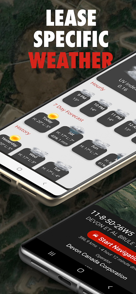
Find oil and gas locations across the US with ease. Get turn-by-turn directions, view well data, weather forecasts, drop pins to see location name, and share well info and location coordinates with OilTrails. The only app that combines all these features with a simple yet powerful interface.
This multifunctional lease locator app makes getting to work in the oilfield a breeze. Simply enter the legal land description, name, or API number to view the surface location OR drop a pin on the map to view location and well info (if vertical). The location can be opened in Apple or Google maps for turn by turn navigation. Change the origin location to see step-by-step directions to location from the nearest town, useful for putting together ERPs or providing visitors directions.
No cell service? No problem. As long as turn by turn navigation is started before service is lost, the directions will continue to function so you don't have to worry about being stranded halfway to location.
Enter a location and view well information such as the operating company, depth, drill date, current status, downhole fluid, formation, and more. Data varies depending on the region.
See the current, future AND past weather specific to the location entered. Wondering if the lease is too wet or has snow to be cleared? View the precipitation the location was forecasted to receive in the past three days. Scroll for 48 hrs of hourly forecasts, 7 daily forecasts, and previous forecasts.
Drop a pin on the map to see the location and well info for that location.
View history of past locations viewed and date they were looked up. Makes driving logs and reports a breeze by knowing where and when you were. Create an account to save and sync locations between devices.
Maps can be shown in a variety of ways including Topographical, 3D Satellite, 2D Satellite, Dark Roads, and Light Roads.
Take GeoPics, geographical and date/time stamped photos that you can save to your device or share.
-Turn by turn GPS navigation in Google Maps
-Enter downhole location to view well info such as the operating company, depth, drill date, current status, -downhole fluid
-View the current weather at location as well as hourly and daily forecast AND previous forecasts to see if the location has received rain/snow is the past three days
-See location in app and view with standard, hybrid, or 3D satellite imagery
-Store history of previously viewed wells/locations
-Share location and well info via message
-Drop pins on the map to see that location's LSD and well info
-International support, find wells in the United States and Australia
Ad
Skærmbilleder


Video
Nyheder
- Version: 2.2.017
- Opdateret:
- -Reverse Geocode Hotfix
- Minor performance improvements and stability fixes
Prishistorie
-
* Indkøb i appen - I dag: Gratis
- Minimum: Gratis
- Maksimalt: Gratis
Overvåg priser
Ad
Udvikler
- Ash Point Software
- Platforme: Android Apps (3)
- Lister: 0 + 0
- Point: 3 + 0 ¡
- Rangeringer: 0
- Anmeldelser: 0
- Kommentarer: 0
- Rabatter: 0
- Videoer: 1
- RSS: Abonner


Rangeringer (0)
0 ☹️
Lister (0)
0 ☹️
- OilTrails
Anmeldelser (0)
Vær den første til at gennemgå 🌟
Kommentarer (0)
Vær den første til at kommentere 🌟
Yderligere oplysninger
- Version: 2.2.017
- Kategori:
Android Apps›Kort og navigation - Operativsystem:
Android 9 - Størrelse:
28 Mb - Indholdsklassificering:
Everyone - Google Play Bedømmelse:
0 - Opdateret:
- Udgivelsesdato:
Kontaktpersoner
- Websted:
 http://oiltrails.ca
«OilTrails». Platform: Android. Kategori: Kort og navigation. Udvikler: «Ash Point Software». Første udgivelse: . Sidste opdatering: . Nuværende pris: gratis. Denne titel har endnu ikke modtaget vurderinger eller anmeldelser på AppAgg. Sporede punkter: bekræftede 3, indirekte 0. AppAgg sporer prishistorik, vurderinger og brugerfeedback for «OilTrails». Følg fremtidige rabatter og opdateringer via RSS. AppAgg hoster ikke applikationer eller distribuerer software. Alle varemærker, logoer og skærmbilleder tilhører deres respektive ejere.
- 🌟 Del
- Google Play
Du vil måske også kunne lide
-
- Trails Offroad: Offline Maps
- Android Apps: Kort og navigation Ved: Trails Offroad
- * Gratis
- Lister: 0 + 0 Rangeringer: 0 Anmeldelser: 0
- Point: 0 + 293 (4.3) Kommentarer: 0 Version: 3.9.0-309001293 Explore with Confidence. Go Beyond the Pavement. Trails Offroad is the #1 app for discovering, planning, and navigating off-road adventures whether you're behind the wheel of a Jeep, ... ⥯
-
- OnPoint Trails: OHV Trail Map
- Android Apps: Kort og navigation Ved: On Point Trails
- * Gratis
- Lister: 0 + 0 Rangeringer: 0 Anmeldelser: 0
- Point: 0 + 0 Kommentarer: 0 Version: 2.4 OnPoint Trails: Your Ultimate Offline Off-Road Navigator Discover the freedom of off-roading with OnPoint Trails, the all-in-one app designed for adventurers who seek to explore CA OHV ⥯
-
- Tripolis Trails
- Android Apps: Kort og navigation Ved: CODABLE GR
- Gratis
- Lister: 0 + 0 Rangeringer: 0 Anmeldelser: 0
- Point: 0 + 0 Kommentarer: 0 Version: 1.1.0 Information about trails and historic places of the War of Independence 1821 at Municipality of Tripolis, Arcadia, Greece. ⥯
-
- Wikiloc - Trails of the World
- Android Apps: Kort og navigation Ved: Wikiloc Outdoor
- * Gratis
- Lister: 0 + 0 Rangeringer: 0 Anmeldelser: 0
- Point: 0 + 144,748 (4.5) Kommentarer: 0 Version: New The Outdoors Community App. Wikiloc is the go-to outdoor navigation application for hiking, cycling, and over 80 other outdoor activities with millions of members worldwide. Find your ... ⥯
-
- Boulder Bike Trails
- Android Apps: Kort og navigation Ved: ColoradoSingleTrack
- Gratis
- Lister: 0 + 0 Rangeringer: 0 Anmeldelser: 0
- Point: 0 + 0 Kommentarer: 0 Version: 20.7 Choose from dozens of single-track mountain biking trails on an interactive map of the Boulder/Denver area of Colorado. Sections of the Colorado Trail between Denver and Breckenridge ... ⥯
-
- GPS Distance Calculator Trails
- Android Apps: Kort og navigation Ved: LogiSian
- * Gratis
- Lister: 0 + 0 Rangeringer: 0 Anmeldelser: 0
- Point: 2 + 0 Kommentarer: 0 Version: 1.0.10 A powerful GPS distance measurement app for tracking your outdoor adventures! Whether you're walking, running, cycling, hiking, or driving, this powerful GPS tracker helps you measure ... ⥯
-
- Bike, Run, Hike Trails Mapeak
- Android Apps: Kort og navigation Ved: Mapeak
- * Gratis
- Lister: 0 + 0 Rangeringer: 0 Anmeldelser: 0
- Point: 0 + 0 Kommentarer: 0 Version: 9.21.194 TOPOGRAPHIC MAPS WITH ROUTE PLANNING, TRACKING & OFFROAD HIKING, RUNNING, BIKING & RIDING TRAILS Mapeak is a modern off-road running, riding, and hiking navigation and route-planning ... ⥯
-
- Paths and Trails Funäsfjällen
- Android Apps: Kort og navigation Ved: Destination Funäsfjällen
- Gratis
- Lister: 0 + 0 Rangeringer: 0 Anmeldelser: 0
- Point: 0 + 0 Kommentarer: 0 Version: 2.7.6 Welcome to Funäsfjällen! With Trails and Trails you get information about the official trails in Funäsfjällen for cycling, hiking, snowmobiling and cross-country skiing. You get ... ⥯
-
- MAPGEARS Trails
- Android Apps: Kort og navigation Ved: Mapgears
- Gratis
- Lister: 0 + 0 Rangeringer: 0 Anmeldelser: 0
- Point: 0 + 0 Kommentarer: 0 Version: 2.0.4 The Mapgears Trails mobile app brings the full power of the Mapgears Trails platform directly to your smartphone, enabling seamless collaboration between the web and mobile experience. ⥯
-
- FunTreks 4x4 Offroad Trails
- Android Apps: Kort og navigation Ved: FunTreks
- $59.99
- Lister: 0 + 0 Rangeringer: 0 Anmeldelser: 0
- Point: 0 + 6 (4.0) Kommentarer: 0 Version: 1.4.7 You re itching to find the best offroading trails, and we re right there with you. There s nothing worse than setting out on a grand adventure only to realize the information you have ... ⥯
-
- Collie Wambenger Trails
- Android Apps: Kort og navigation Ved: Dept of Biodiversity, Conservation and Attractions
- Gratis
- Lister: 0 + 0 Rangeringer: 0 Anmeldelser: 0
- Point: 0 + 0 Kommentarer: 0 Version: 9.0.489-prod Located in South West Western Australia, Wambenger Trails offer mountain biking, walking and paddling trails, camping and water sports. This app is your go to guide for discovering all ⥯
-
- Terra Incognita - Trails Map
- Android Apps: Kort og navigation Ved: Patrick Salecker
- Gratis
- Lister: 0 + 0 Rangeringer: 0 Anmeldelser: 0
- Point: 0 + 0 Kommentarer: 0 Version: 0.3.10 Terra Incognita is a GPS route tracker and trip viewer, that allows you to record your route and view your GPX files. It can visualize them uniquely, where each step reveals more of ... ⥯
- Ny
- Hiking Trails
- Android Apps: Kort og navigation Ved: Loc Square
- Gratis
- Lister: 0 + 0 Rangeringer: 0 Anmeldelser: 0
- Point: 0 + 0 Kommentarer: 0 Version: 1.0.0 Meet Hiking Trails your all-in-one trail companion. Discover the right route, plan with powerful map tools, see live locations with your crew, and keep navigating offline. What you can ⥯
-
- Colorado Springs Trails
- Android Apps: Kort og navigation Ved: Quibus Enterprises, Inc.
- Gratis
- Lister: 0 + 0 Rangeringer: 0 Anmeldelser: 0
- Point: 0 + 10 (4.0) Kommentarer: 0 Version: 1.21 Colorado Springs, Colorado has an abundance of interesting places to hike and bike. This app catalogs over 200 trails in and around Colorado Springs, divided into 18 areas including ... ⥯