| ผู้พัฒนา: | Skippo Boatlife (4) | ||
| ราคา: | * * ฟรี | ||
| การจัดอันดับ: | 0 | ||
| ความเห็น: | 0 เขียนความเห็น | ||
| รายการ: | 0 + 0 | ||
| แต้มแล: | 0 + 4,802 ¡ | ||
| แต้มแล + 1 | |||
คำอธิบาย
")
Eniro På Sjön is now part of Skippo. If you already have an account and/or subscription in the På Sjön app, they will continue to work as usual in Skippo, and your profile information with saved places and tracks will remain.
***Official navigation partner of KSSS and Gotland Runt.
PLAN
Search islands and coordinates, explore guest and nature harbors, and save your favorite places in your boat profile. Use wind and weather forecasts to plan your route or let our automatic route planning give you the fastest and most fuel-efficient route to your destination. If your destination is a guest harbor, you can book a guest harbor spot directly from the app.
NAVIGATE
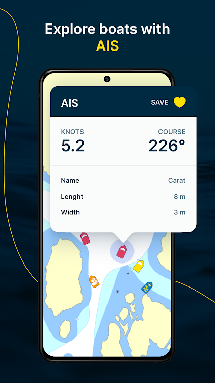
Navigate using locally adapted nautical charts and aerial photos that you can also download and use offline. Clear instrument panel with speed in knots (SOG) and course (COG). Customize your view with zoom, lock the boat's direction, and add map layers such as ports, AIS boats, your own saved locations or wind and weather forecasts. Let our anchor watch keep track of your boat's position if you are at anchor.
LOG
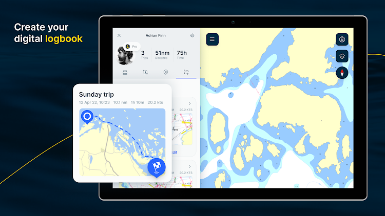
Create your personal boat profile with name, picture, and boat information. In your profile, you can save your favorite places, plotter tracks, and the routes you created manually or with our automatic route planning. With Skippo, you can keep track of your boatlife and view statistics on your boat trips, distance traveled and time on the water. As a Pro user, you can also access our web app {link to https://webapp-se.skippo.io/}.
CREATE A FREE ACCOUNT
- Personal boat profile with boat info, picture, and measurements
- Digital logbook
- Search islands, geography, and coordinates
- Discover other boats and get information about them with AIS
- "Man overboard" safety button
- Symbol explanation for nautical chart symbols
- Synchronization of data and routes between devices
UPGRADE TO PRO (3-day free trial)
- Instrument panel to view speed and course
- Trip meter showing distance traveled
- Navigation tools (e.g. lock boat symbol so that chart rotates)
- Automatic route planning
- Wind and weather forecasts (not available for Android)
- Offline sea charts
- Measure and calculate distances and compass course
- Harbor information with services and facilities
- Switch between sea charts and nautical aerial photos
- Book guest harbor spots directly from the app
- Keep screen awake (prevent screen from locking)
- Export and import GPX files to/from your plotter
- Access to the service online in our web app
ADD SPECIAL CHARTS FROM HYDROGRAPHICA FOR A COMPLETE EXPERIENCE (3-day free trial)
- Special sea charts from Hydrographica
- Navigate in shallow waters
- Open up safe routes and passages
- Natural harbors with designated mooring spots
NAVIGATE IN DANISH WATERS
- Access to Danish sea charts can be added as an additional subscription
Do you have a question? Visit our support center https://help.skippo.io
If you have feedback or other suggestions, please send them via this form: https://help.skippo.io/en/support/tickets/new
ภาพหน้าจอ


มีอะไรใหม่
- เวอร์ชัน: 8.1.34.79
- อัปเดต:
ราคา
-
*มีโฆษณา*การซื้อภายในแอพ - วันนี้: ฟรี
- ต่ำสุด: ฟรี
- มากที่สุด: ฟรี
ติดตามราคา
ผู้พัฒนา
- Skippo Boatlife
- แพลตฟอร์ม: Android แอป (4)
- รายการ: 0 + 0
- แต้มแล: 3 + 6,415 ¡
- การจัดอันดับ: 0
- ความเห็น: 0
- ลดราคา: 0
- วิดีโอ: 0
- RSS: ติดตาม
แต้มแล
ไม่พบ ☹️
การจัดอันดับ
ไม่พบ ☹️
รายการ
ไม่พบ ☹️
ความเห็น
แสดงรีวิวเป็นคนแรกเลย!
ข้อมูลเพิ่มเติม
- หมวดหมู่:
Android แอป›แผนที่และการนำทาง - ระบบปฏิบัติการ:
Android 7.0 และสูงกว่า - ขนาด:
24 Mb - การจัดประเภทเนื้อหา:
Everyone - Google Play คะแนนโดย:
3.2(4,802) - อัปเดต:
- วันที่วางจำหน่าย:
รายชื่อติดต่อ
- เว็บไซท์:
 https://webapp-se.skippo.io/
คุณอาจชอบ
-
- Skippo Finland
- Android แอป: แผนที่และการนำทาง โดย: Skippo Boatlife
- * * ฟรี
- รายการ: 0 + 0 การจัดอันดับ: 0 ความเห็น: 0
- แต้มแล: 0 + 884 เวอร์ชัน: 8.1.34.80 Join our boating community with soon-to-be one million users in the Nordics and access a personalized and user-friendly app experience with nautical charts and services specifically ...
-
- Sweden Topo Maps
- Android แอป: แผนที่และการนำทาง โดย: ATLOGIS Geoinformatics GmbH & Co. KG
- * * ฟรี
- รายการ: 0 + 0 การจัดอันดับ: 0 ความเห็น: 0
- แต้มแล: 0 + 2,743 เวอร์ชัน: 7.2.2 Easy to use Outdoor/Offline GPS navigation app with access to the best topographic maps and satellite images for Sweden. ++ For offline use PRO features needed ! ++ Turn your Andoid ...
-
- Mer Connect Norway
- Android แอป: แผนที่และการนำทาง โดย: Mer AS
- ฟรี
- รายการ: 0 + 0 การจัดอันดับ: 0 ความเห็น: 0
- แต้มแล: 0 + 1,030 เวอร์ชัน: 3.2.5 Mer Connect gives you access to Mer's nationwide charging network in Norway. With over 800 Rapid and Ultra Rapid Chargers throughout Norway, Mer makes sure you get where you want to ...
-
- MapFactor Navigator
- Android แอป: แผนที่และการนำทาง โดย: MapFactor
- * * ฟรี
- รายการ: 0 + 0 การจัดอันดับ: 5 (1) ความเห็น: 0
- แต้มแล: 0 + 994,134 เวอร์ชัน: 7.3.51 * Best rated free offline navigation app on Google Play with 35 mil+ installs* Now for Android Auto! MapFactor Navigator is a free GPS navigation app with free offline maps from ...
-
- AR GPS DRIVE/WALK NAVIGATION
- Android แอป: แผนที่และการนำทาง โดย: walter hsieh
- * ฟรี
- รายการ: 0 + 0 การจัดอันดับ: 0 ความเห็น: 0
- แต้มแล: 0 + 5,743 เวอร์ชัน: Beta 63.0 This application is using smartphone's GPS and camera to implement an augmented reality-powered car navigation system.It is easier and safer than the traditional navigation system for ...
-
- NV Charts GPS Navigation AIS
- Android แอป: แผนที่และการนำทาง โดย: NV CHARTS
- * ฟรี
- รายการ: 0 + 0 การจัดอันดับ: 0 ความเห็น: 0
- แต้มแล: 0 + 1,783 เวอร์ชัน: 2.714.192 The NV Charts navigation app with an intuitive interface and powerful tools is a must-have for onboard navigation while cruising, fishing, sailing, diving or any other activity on the ...
-
- Jahtikartta outdoor GPS map
- Android แอป: แผนที่และการนำทาง โดย: J3 Systems Oy
- * ฟรี
- รายการ: 0 + 0 การจัดอันดับ: 0 ความเห็น: 0
- แต้มแล: 0 + 508 เวอร์ชัน: 1.28.2 Jahtikartta outdoor GPS map is a great application with all the necessary map functions: Offline terrain maps of Finland, Sweden and Norway. Offline maps work without a network ...
-
- Seapilot
- Android แอป: แผนที่และการนำทาง โดย: Seapilot
- * ฟรี
- รายการ: 0 + 0 การจัดอันดับ: 0 ความเห็น: 0
- แต้มแล: 0 + 711 เวอร์ชัน: 4.5.1 Professional marine navigation used to require an expensive GPS plotter. Now, same technology used in merchant shipping is available for your Android device. Use it to navigate, to ...
-
- URBI: your mobility solution
- Android แอป: แผนที่และการนำทาง โดย: URBANnext SA
- ฟรี
- รายการ: 0 + 0 การจัดอันดับ: 0 ความเห็น: 0
- แต้มแล: 0 + 989 เวอร์ชัน: 6.6 GO PLACES WITH URBI! All the urban mobility in one App: car, scooter, escooter, bike sharing + public transport and taxi! With URBI you will be able to: - manage easily in map the ...
-
- SL Stockholm Commute
- Android แอป: แผนที่และการนำทาง โดย: Apptastic Software
- * ฟรี
- รายการ: 0 + 0 การจัดอันดับ: 0 ความเห็น: 0
- แต้มแล: 0 + 704 เวอร์ชัน: 2.9.3 Journey planner for Stockholm Sweden Public Transport (SL, Stockholms Lokaltrafik) The Stockholm Commute app finds the smartest trips for you. It searches all transport types available
-
- Maastokartat
- Android แอป: แผนที่และการนำทาง โดย: MapsiTech Oy
- * ฟรี
- รายการ: 0 + 0 การจัดอันดับ: 0 ความเห็น: 0
- แต้มแล: 0 + 20,574 เวอร์ชัน: 2.1.20 Free topographic map enhances outdoor activities and aids in the exploration of new places. It enables you to effortlessly determine your location and understand your surroundings. You
-
- Bans For Trucks - Europe
- Android แอป: แผนที่และการนำทาง โดย: Trucker Apps
- * * ฟรี
- รายการ: 0 + 0 การจัดอันดับ: 0 ความเห็น: 0
- แต้มแล: 0 + 9,107 เวอร์ชัน: 4.4.2 Periodic restrictions and bans for trucks. Join the community of more than 250 000 Bans For Trucks drivers Main functions: 1) Permanent bans - 40 countries: Albania, Austria, Belgium, ...
-
- Train/Subway NAVITIME Transit
- Android แอป: แผนที่และการนำทาง โดย: NT TRAVEL Co., Ltd.
- * * ฟรี
- รายการ: 0 + 0 การจัดอันดับ: 0 ความเห็น: 0
- แต้มแล: 0 + 1,316 เวอร์ชัน: 2.34.0 NAVITIME Transit allows you to search for routes while looking at the route map. It is a free app that provides safe and secure travel while on overseas holidays, business trips, and ...
-
- Mapitare Terrain and Sea Map
- Android แอป: แผนที่และการนำทาง โดย: Mapitare Oy
- * ฟรี
- รายการ: 0 + 0 การจัดอันดับ: 0 ความเห็น: 0
- แต้มแล: 0 + 166 เวอร์ชัน: 1.3.74 MAPITARE TERRAIN AND SEA MAP Now you can try all the maps free for seven days (©Sjöfartsverket three days)! Mapping software downloaded into your mobile phone s memory improves your ...