| ผู้พัฒนา: | Extensis (6) | ||
| ราคา: | ฟรี | ||
| การจัดอันดับ: | 0 | ||
| ความเห็น: | 0 เขียนความเห็น | ||
| รายการ: | 0 + 0 | ||
| แต้มแล: | 0 + 151 ¡ | ||
| แต้มแล + 1 | |||
คำอธิบาย
")
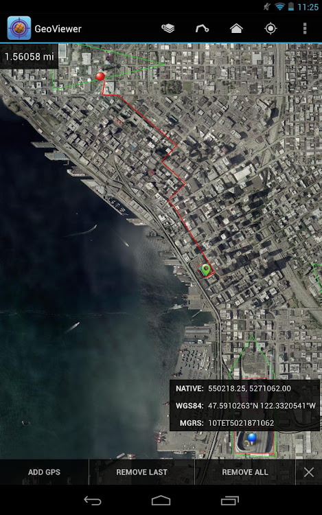
Things you can do with GeoViewer:
• Open MrSID and JPEG 2000 images.
• Select bands to view from a multispectral image.
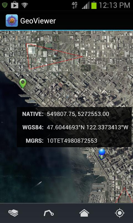
• Explore imagery by panning, zooming in and zooming out.
• Add vector overlays (Esri Shapefiles and KML files) to get more out of image layers.
• Center on your GPS location so you can see what’s nearby.
• Measure the distance between a series of points.
• Identify geolocation by touching on any image.
• View layer properties, including coordinate reference system, geo bounding box, dimensions, colorspace, datatype, and resolution.
• Search by geographic coordinates in WGS 84 (Lat/Long) or the image’s native coordinate reference system.
• Set viewing preferences (band selection, layer line color, etc.).
By installing or using this App you agree to be bound by the terms and conditions of the End User License Agreement, https://www.extensis.com/geoviewer-for-android-eula.
ภาพหน้าจอ

มีอะไรใหม่
- เวอร์ชัน: New
- อัปเดต:
- Bug fixes.
ราคา
- วันนี้: ฟรี
- ต่ำสุด: ฟรี
- มากที่สุด: ฟรี
ติดตามราคา
ผู้พัฒนา
- Extensis
- แพลตฟอร์ม: Android แอป (1) iOS แอป (4) macOS แอป (1)
- รายการ: 0 + 0
- แต้มแล: 0 + 170 ¡
- การจัดอันดับ: 0
- ความเห็น: 0
- ลดราคา: 0
- วิดีโอ: 0
- RSS: ติดตาม
แต้มแล
ไม่พบ ☹️
การจัดอันดับ
ไม่พบ ☹️
รายการ
ไม่พบ ☹️
ความเห็น
แสดงรีวิวเป็นคนแรกเลย!
ข้อมูลเพิ่มเติม
- หมวดหมู่:
Android แอป›ประสิทธิภาพการผลิต - ระบบปฏิบัติการ:
Android - การจัดประเภทเนื้อหา:
Everyone - Google Play คะแนนโดย:
3.9(151) - อัปเดต:
- วันที่วางจำหน่าย:
รายชื่อติดต่อ
- เว็บไซท์:
 https://www.extensis.com
คุณอาจชอบ
-
- GEO Pro Notebook -Note Taking
- Android แอป: ประสิทธิภาพการผลิต โดย: GEO SOFTECH
- $0.49
- รายการ: 0 + 0 การจัดอันดับ: 0 ความเห็น: 0
- แต้มแล: 2 + 65 เวอร์ชัน: 3.0 GEO PRO Notebook Create Text , Images And Voice Notes No Ads Privacy Friendly: This app doesn't collect any user data or connect to anything on the user's device (contacts etc). It ...
-
- GEO by BuildingLink.com
- Android แอป: ประสิทธิภาพการผลิต โดย: BuildingLink.com, LLC
- ฟรี
- รายการ: 0 + 0 การจัดอันดับ: 0 ความเห็น: 0
- แต้มแล: 0 + 198 เวอร์ชัน: 3.15.6 THIS APP IS FOR MANAGERS AND STAFF ONLY. IF YOU RE A RESIDENT, PLEASE DOWNLOAD OUR RESIDENT APP. Download GEO for Android to access the time-saving, work-reducing features that make ...
-
- Geo-IDBI
- Android แอป: ประสิทธิภาพการผลิต โดย: IDBI BANK
- ฟรี
- รายการ: 0 + 0 การจัดอันดับ: 0 ความเห็น: 0
- แต้มแล: 0 + 148 เวอร์ชัน: 6.1.17 Geo-IDBI will help IDBIns to capture visit details along with locations and photographs on real time basis. The system will not only help in locating assets charged to bank but also to
-
- Fast STL Viewer
- Android แอป: ประสิทธิภาพการผลิต โดย: Fast STL Viewer
- * * ฟรี
- รายการ: 0 + 0 การจัดอันดับ: 0 ความเห็น: 0
- แต้มแล: 0 + 3,105 เวอร์ชัน: 2.11 Problem: Please note that Samsung's "My Files" file browser has a known bug and does not open STL files directly in the app because it fails to associate the STL extension with the ...
-
- All Documents Viewer
- Android แอป: ประสิทธิภาพการผลิต โดย: Apps Vendors
- * * ฟรี
- รายการ: 0 + 0 การจัดอันดับ: 0 ความเห็น: 0
- แต้มแล: 0 + 54,807 เวอร์ชัน: 1.4.9 The All Documents Viewer: Office Suite Doc Reader helps you in veiwing & reading multiple Documents formats such as Doc & Docx, pdf, ppt, xls, txt, odt, rtf, html & other document ...
-
- All Document Reader and Viewer
- Android แอป: ประสิทธิภาพการผลิต โดย: Green Rocket Apps
- * * ฟรี
- รายการ: 0 + 0 การจัดอันดับ: 0 ความเห็น: 0
- แต้มแล: 0 + 34 เวอร์ชัน: 2.5 Are You Looking for a Versatile Document Reader application? or want to quickly open all formats of files on your phone with one App? Document Reader and Document Viewer is a Powerful ...
-
- All Document Viewer:Pdf Reader
- Android แอป: ประสิทธิภาพการผลิต โดย: 9appstech
- * * ฟรี
- รายการ: 0 + 0 การจัดอันดับ: 0 ความเห็น: 0
- แต้มแล: 0 + 1,718 เวอร์ชัน: 2.8.4 Cannot open your documents like PDF, Excel sheet, Power point file or Word file in your mobile phone? Now view all your documents like PDF, DOC, EXCEL and PPT on your mobile phones ...
-
- Tiff File Viewer PDF Converter
- Android แอป: ประสิทธิภาพการผลิต โดย: Aardvark Solutions
- * ฟรี
- รายการ: 0 + 0 การจัดอันดับ: 0 ความเห็น: 0
- แต้มแล: 0 + 257 เวอร์ชัน: 1.1.2 The tiff file viewer / tiff viewer android allows the user to view tiff files easily using their smartphone. Tff / tiff file viewer for android permits the user to convert those files ...
-
- All Documents Reader & Viewer
- Android แอป: ประสิทธิภาพการผลิต โดย: Apex Valley Apps
- * ฟรี
- รายการ: 0 + 0 การจัดอันดับ: 0 ความเห็น: 0
- แต้มแล: 0 + 19,956 เวอร์ชัน: 6.9.11 Now you can view and sort out all your documentation work on your phone as this all-in-one document reader is used to view, read, and share all kinds of document files. For reading ...
-
- PDF Reader - All PDF Viewer
- Android แอป: ประสิทธิภาพการผลิต โดย: Cybill Tech Mobile Apps
- * * ฟรี
- รายการ: 0 + 0 การจัดอันดับ: 0 ความเห็น: 0
- แต้มแล: 0 + 261 เวอร์ชัน: 2.19 Welcome to PDF Reader-All PDF Viewer and document management app. Whether you're a student, a professional, or just someone who needs to handle PDF documents regularly, PDF Reader is ...
-
- XLSX Reader: XLS Viewer Editor
- Android แอป: ประสิทธิภาพการผลิต โดย: A1 Office Apps
- * ฟรี
- รายการ: 0 + 0 การจัดอันดับ: 0 ความเห็น: 0
- แต้มแล: 0 + 205 เวอร์ชัน: 1.1.3 XLSX Reader: You can set the XLSX Reader & Spreadsheets Editor app as your default All-in-One XLSX app and use it to open XLS, CSV, XLSX, XLSM, and Sheets directly from the web, email ...
-
- PSD viewer - File viewer for P
- Android แอป: ประสิทธิภาพการผลิต โดย: hongthuanjsc
- * * ฟรี
- รายการ: 0 + 0 การจัดอันดับ: 0 ความเห็น: 0
- แต้มแล: 0 + 5,034 เวอร์ชัน: 15 Easily view Adobe Photoshop (.psd) files on your Android with PSD viewer - File viewer for Photoshop What are PSD files? PSD file represent image file types that are created with the ...
-
- XLSX Reader - Excel Viewer
- Android แอป: ประสิทธิภาพการผลิต โดย: TrustedOffice
- * * ฟรี
- รายการ: 0 + 0 การจัดอันดับ: 0 ความเห็น: 0
- แต้มแล: 0 + 134,956 เวอร์ชัน: 1.3.5 The highlight of the XLSX reader Excel viewer app: Quick page navigation to see XLSX, see Excel file Read file XLSX without an Internet connection, docs viewer offline Friendly ...
-
- All Document Reader & Viewer
- Android แอป: ประสิทธิภาพการผลิต โดย: Andromeda App
- * * ฟรี
- รายการ: 0 + 0 การจัดอันดับ: 0 ความเห็น: 0
- แต้มแล: 1 + 650 เวอร์ชัน: 2.1.0 All Document Reader & Viewer: Read all PDF Files, Word, Excel, PPT and other Documents Are you wondering which is an excellent Document app to help you read all of your files? Please ...