| Разработчик: | vTools Apps (2) | ||
| Цена: | Бесплатно | ||
| Рейтинги: | 0 | ||
| Отзывы: | 0 Написать отзыв | ||
| Списки: | 1 + 0 | ||
| Очки: | 0 + 0 ¡ | ||
| Google Play | |||
Описание
")
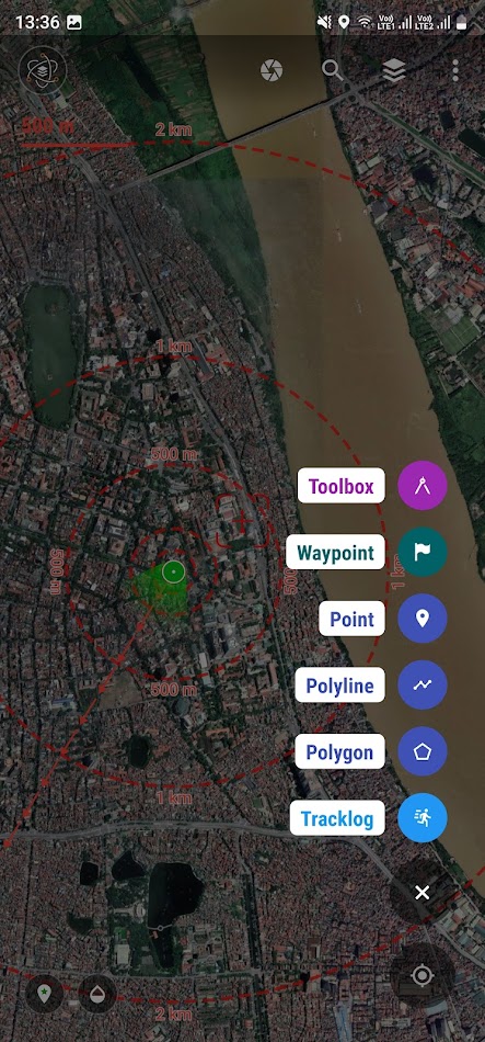
- All map data files management, field surveying and mapping with GPS
- Positioning, current position, practical view angle in the field. Help identify better directions.
- Allows users to directly create objects (Points, Lines, Polygons, Coordinate Waypoints, Tracklog routes).
- Allows rapid measurement of the area and length of objects in the field.
- Users can simultaneously create Tracklog, Point, Line, and Polygon at the same time while moving. Tracklog mode allows running in the background.
- Support to save attribute information and images in the field.
- Users can define forms fields to collect. And share quickly to the whole group via QR code or export to file.
- Find for waypoint, enter a list of waypoints from data TEXT(*.txt), Excel (*.xls, *.xlsx), CSV (*.csv) Excel and convert point coordinates directly on the device.
- Allow to enter the list of points to check by hand (For example, it is necessary to check the location of the extract of the red book).
- Support directly opening common data such as Excel, GPS/GPX, KML/KMZ, GeoJSON, AutoCAD DXF, MicroStation DGN, ESRI Shapefile SHP, MapInfo TAB, gCadas GTP, GeoTIFF, JPG, PNG
- Support export data to GPX, KML, GeoJSON, Excel, AutoCAD DXF, MapInfo TAB, Shapefile SHP format and share via Email, Drive, Zalo, Facebook etc.
- Fully support the VN 2000 projection system of the local and nationwide of Vietnam.
- Support more than 5000 projection systems of other countries and territories in the world.
- Support for old projection systems like Hanoi 1972 (HN 72).
- Support numerical compass feature
- Support reading offline map data MBTiles and intelligent management of data layers.
- Support with simple MBTiles convert tool on Desktop, help to view properties directly from MBTiles layer.
- Support conversion of TCVN3, VNI encoding for Vietnamese font in viewing attribute information.
- Support field photography, save location, shooting direction on images and Exif information, GeoTag
- Allow users to download Google, MapBox, Bing, ESRI, OSM directly on the computer for offline use.
- Support web map service TMS and WMS.
- The feature allows users to directly find and use Landsat 8 satellite image data (16-day update cycle) and Sentinel 2 (5-day update cycle) from the image database.
- Location view feature with 3D perspective with global elevation digital model.
If you need assistance please contact us at the following information:
Facebook: https://www.facebook.com/vToolsForMapInfo
Email: vtools.cskh@gmail.com
Phone (Zalo, Telegram): (+84) 96 990 4596
Website: https://apps.vtools.xyz
Youtube: https://www.youtube.com/c/vTools/playlists
All Rights Reserved. Copyright © vTools Apps
Скриншоты


Видео
Что нового
- Версия: 8.7.1
- Обновлено:
- Update version v8.7.1
- Add configuration and support for sharing via QR code for TMS and WMS services
- Update interface for selecting basemap service, blurring map data layers
- Support projection configuration option for GeoJSON layer if not using default EPSG:4326 projection
- Optimize project management interface
- Automatically adjust the distance of display labels for POINT and MARKER coordinate data depending on the installed icon size
- Fix bugs...
Цена
- Сегодня: Бесплатно
- Минимум: Бесплатно
- Максимум: Бесплатно
Отслеживайте цены
Разработчик
- vTools Apps
- Платформы: Android Приложения (2)
- Списки: 1 + 0
- Очки: 3 + 0 ¡
- Рейтинги: 0
- Отзывы: 0
- Скидки: 0
- Видео: 2
- RSS: Подписаться
Очки
0 ☹️
Рейтинги
0 ☹️
Списки

Отзывы
Ваш отзыв будет первым 🌟
Дополнительная информация
- Версия: 8.7.1
- ID: com.xyz.survey
- Категория:
Android Приложения›Инструменты - Операционные системы:
Android 8.0 - Размер:
26 Mb - Возрастные ограничения:
Everyone - Google Play Рейтинг:
0 - Обновлено:
- Дата выпуска:
Контакты
- Facebook: vToolsForMapInfo
- Сайт:
 https://docs.vtools.xyz/
Вам также могут понравиться
-
- vTools Survey Pro - GIS Expert
- Android Приложения: Инструменты От: vTools Apps
- $144.99
- Списки: 0 + 0 Рейтинги: 0 Отзывы: 0
- Очки: 3 + 0 Версия: 8.7.1 The application makes mapping, management planning and field inspection simple, fast and convenient. Fully integrated with the same functions as a handheld GPS and also adds many new ... ⥯
-
- Drone Survey - Drone Mapping
- Android Приложения: Инструменты От: SjajnoAplikeRazvoj
- * Бесплатно
- Списки: 0 + 0 Рейтинги: 0 Отзывы: 0
- Очки: 0 + 0 Версия: 5.0 Take control of your drone missions with Drone Survey Drone Mapping, the ultimate app for flight planning, surveying, and photogrammetry. Designed for drone enthusiasts, hobbyists, and ⥯
-
- GPS Tracker
- Android Приложения: Инструменты От: GPS-server.net
- Бесплатно
- Списки: 0 + 0 Рейтинги: 0 Отзывы: 0
- Очки: 1 + 420 (3.3) Версия: 2.13 With GPS Tracker application you can transform your Android mobile device to GPS tracker (GPS tracking device) and use all GPS-server.net features. In order to use this application, ... ⥯
-
- GPS-Buddy RFID-Tag Scanner
- Android Приложения: Инструменты От: GPS-Buddy
- Бесплатно
- Списки: 0 + 0 Рейтинги: 0 Отзывы: 0
- Очки: 0 + 0 Версия: App v1.2.1 Scan and configure your GPS Buddy RFID Tags with this app ⥯
-
- GPS Speedometer & Odometer App
- Android Приложения: Инструменты От: Pixamattic Inc -Live Earth Cameras, GPS Navigation
- * * Бесплатно
- Списки: 0 + 0 Рейтинги: 0 Отзывы: 0
- Очки: 0 + 0 Версия: 1.2.0 Do you love to know about the speed of the vehicles when you travel? GPS Speedometer & Odometer App is the only way to know about the speed of the vehicle on which you are traveling. ... ⥯
-
- Cave 09 - Survey & Mapping
- Android Приложения: Инструменты От: Managrr
- Бесплатно
- Списки: 0 + 0 Рейтинги: 0 Отзывы: 0
- Очки: 0 + 0 Версия: 3.0.3 Explore the depths of the underground world with Cave09, your essential tool for efficient cave mapping. Designed by cavers for cavers, Cave09 offers data input for mapping, automatic ... ⥯
-
- Titan GPS Install
- Android Приложения: Инструменты От: GPS Insight
- Бесплатно
- Списки: 0 + 0 Рейтинги: 0 Отзывы: 0
- Очки: 0 + 0 Версия: 1.0.3 The Titan GPS Install app allows you to seamlessly verify and test GPS tracking devices for fleet tracking businesses at any time. GPS hardware installers can avoid call-in activation ... ⥯
-
- GPS Speed Tracker: Speedometer
- Android Приложения: Инструменты От: Vasundhara Infotech LLC
- * * Бесплатно
- Списки: 0 + 0 Рейтинги: 0 Отзывы: 0
- Очки: 0 + 517 (3.3) Версия: 1.8 GPS Speed Tracker: Speedometer Accurate Speed Tracking Wherever You Go Stay in control of your speed and travel data with GPS Speed Tracker: Speedometer, the easy-to-use and reliable ... ⥯
-
- GPS Tools with GPS Data
- Android Приложения: Инструменты От: Grey Wood Apps LLC
- * Бесплатно
- Списки: 0 + 0 Рейтинги: 0 Отзывы: 0
- Очки: 0 + 0 Версия: 1.5 GPS Data or GPS Info is a great app which helps you to get all information about your GPS - like latitude, longitude, Altitude, speed and lots more information related to GPS. GPS ... ⥯
-
- GPS Fields Area Measure Tool
- Android Приложения: Инструменты От: Fluent Farming
- * * Бесплатно
- Списки: 0 + 0 Рейтинги: 0 Отзывы: 0
- Очки: 0 + 5,798 (4.4) Версия: 9.0 Accurate GPS Field Area Measurement App Free & Easy to Use This is the ultimate GPS Fields Area Measure tool for land, plots, farms, and road distance calculation. Whether you're a ... ⥯
-
- GPS Speedometer and Odometer
- Android Приложения: Инструменты От: Droid-Developer
- * * Бесплатно
- Списки: 0 + 0 Рейтинги: 0 Отзывы: 0
- Очки: 0 + 6,793 (4.5) Версия: 2.0 This free GPS Speedometer App is a GPS-based speed tracker that can record your driving speed and driving distance accurately, support vertical or horizontal screen display of vehicle ... ⥯
-
- GPS Sight Lite
- Android Приложения: Инструменты От: GP Search Sdn Bhd
- Бесплатно
- Списки: 0 + 0 Рейтинги: 0 Отзывы: 0
- Очки: 0 + 0 Версия: 2.7.5 Mobile GPS Sight Lite app enables users to access GPS Tracking Platform at anytime and anywhere around the world. It offers most of the functionality of the desktop version in a ... ⥯
-
- GPS Maps, Live Navigation
- Android Приложения: Инструменты От: Raamo Apps
- * Бесплатно
- Списки: 0 + 0 Рейтинги: 0 Отзывы: 0
- Очки: 1 + 63,612 (4.2) Версия: 5.72 Navigate smarter with our GPS Maps, Live Navigation all-in-one GPS companion. Find the fastest routes, check live traffic, explore nearby places and use a built-in compass for accurate ⥯
-
- GPS Route Finder
- Android Приложения: Инструменты От: Mobi Softech
- * Бесплатно
- Списки: 0 + 0 Рейтинги: 0 Отзывы: 0
- Очки: 0 + 12,614 (4.8) Версия: 18.04 GPS Route Finder use GPS & Network to get Location on Map Easy, Helps You to Navigate Freely on Maps by knowing the traffic update. Places Near me to work smarter Find the Nearby ... ⥯