| ผู้พัฒนา: | Ocean Signal (5) | ||
| ราคา: | ฟรี | ||
| การจัดอันดับ: | 0 | ||
| ความเห็น: | 0 เขียนความเห็น | ||
| รายการ: | 0 + 0 | ||
| แต้มแล: | 0 + 25 (1.2) ¡ | ||
| App Store | |||
คำอธิบาย
")
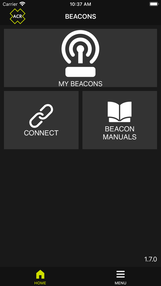
Live AIS targets can be displayed as well as Test and Ownership details for Distress Beacons.
NFC (Near Field Communication) allows access to ResQLink AIS PLB and GlobalFix V5 details where operation time, Battery condition and test results can be easily checked and displayed on a mobile device.
The use of NFC ensures that maximum battery capacity can be ensured giving you confidence that a Beacon will give maximum performance when required in an emergency situation.
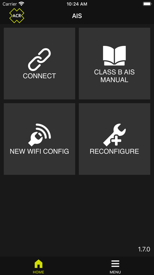
WiFi connection to the ACR CB2 gives access to live AIS target data along with status and performance details. Initial configuration with vessel details for the CB2 Class B AIS is also carried out via the WiFi connection.
ภาพหน้าจอ


ราคา
- วันนี้: ฟรี
- ต่ำสุด: ฟรี
- มากที่สุด: ฟรี
ติดตามราคา
ผู้พัฒนา
- Ocean Signal
- แพลตฟอร์ม: Android แอป (2) iOS แอป (2) macOS แอป (1)
- รายการ: 0 + 0
- แต้มแล: 0 + 40 ¡
- การจัดอันดับ: 0
- ความเห็น: 0
- ลดราคา: 0
- วิดีโอ: 0
- RSS: ติดตาม
แต้มแล
0 ☹️
การจัดอันดับ
0 ☹️
รายการ
0 ☹️
ความเห็น
แสดงรีวิวเป็นคนแรกเลย 🌟
ข้อมูลเพิ่มเติม
รายชื่อติดต่อ
- 🌟 แชร์
- App Store
คุณอาจชอบ
-
- iTAK
- iOS แอป: การนำทาง โดย: United States Department of the Army, TAK Product Center
- ฟรี
- รายการ: 0 + 0 การจัดอันดับ: 0 ความเห็น: 0
- แต้มแล: 0 + 143 (3.7) เวอร์ชัน: 2.12.3 **Compatible with ALL TAK ecosystem (TAK server, WinTAK, ATAK, WebTAK)** The Team Awareness Kit (TAK) (known as the Tactical Assault Kit in the Department of Defense) application: iTAK ⥯
-
- No Roads
- iOS แอป: การนำทาง โดย: i3 Product Development, Inc.
- * ฟรี
- รายการ: 0 + 0 การจัดอันดับ: 0 ความเห็น: 0
- แต้มแล: 0 + 32 (4.9) เวอร์ชัน: 1.6.1 Find and explore off-road trails with No Roads. Drop waypoints, record tracks, and discover thousands of curated trails with real-time updates from fellow explorers. Download maps for ... ⥯
-
- BEIDO MAP-Satellite Streetview
- iOS แอป: การนำทาง โดย: 北京才牛图科技有限公司
- $0.99
- รายการ: 0 + 0 การจัดอันดับ: 0 ความเห็น: 0
- แต้มแล: 0 + 0 เวอร์ชัน: 2.5.0 【Product Introduction】 This is a software for viewing global satellite images and streetscape. Using the new data of 2021, it will bring you the pleasure of seeing the world at home! ... ⥯
-
- My Altitude: GPS Altimeter
- iOS แอป: การนำทาง โดย: Gaurav Babbar
- ฟรี
- รายการ: 1 + 1 การจัดอันดับ: 0 ความเห็น: 0
- แต้มแล: 1 + 8,378 (4.6) เวอร์ชัน: 2.6 Download now the best Altimeter app for Hikers, Trekkers, and GlobeTrotters. Altimeter GPS is a multipurpose app equipped with features like an altimeter, barometer, compass over your ... ⥯
-
- Driver: Driving & Dash Cam App
- iOS แอป: การนำทาง โดย: Driver Technologies Inc.
- ฟรี
- รายการ: 0 + 0 การจัดอันดับ: 0 ความเห็น: 0
- แต้มแล: 1 + 11,804 (4.7) เวอร์ชัน: 6.8.8 Driver is here to ensure you re taken care of on the road. Driver offers a fully connected driving experience through our Cloud + App platform, covering liability protection, roadside ... ⥯
-
- Supercharger map for Tesla
- iOS แอป: การนำทาง โดย: yohan teixeira
- ฟรี
- รายการ: 0 + 0 การจัดอันดับ: 0 ความเห็น: 0
- แต้มแล: 0 + 12,000 (4.7) เวอร์ชัน: 4.9 Supercharger for Tesla is an essential tool for any Tesla owner. With this app, you can easily find a supercharger station near you, so you never have to worry about running out of ... ⥯
-
- Spoke (Circuit) Route Planner
- iOS แอป: การนำทาง โดย: Circuit Routing
- ฟรี
- รายการ: 0 + 0 การจัดอันดับ: 0 ความเห็น: 0
- แต้มแล: 1 + 9,018 (4.7) เวอร์ชัน: 3.20.6 Circuit Route Planner is now Spoke Route Planner. Same trusted app, just a new name. Easy-to-use multi-stop route planner and delivery app downloaded by over 10 million drivers - Sign ... ⥯
-
- PRO CHARTS - Marine Navigation
- iOS แอป: การนำทาง โดย: MiraTrex, Inc.
- ฟรี
- รายการ: 0 + 0 การจัดอันดับ: 0 ความเห็น: 0
- แต้มแล: 0 + 8,377 (4.5) เวอร์ชัน: 5.70 MiraTrex PRO CHARTS™ is a powerful, yet easy-to-use marine navigation system. Whether you re a fisherman, weekend cruiser, sailor, diver, jet-skier, or an offshore captain needing to ... ⥯
-
- RoadWarrior Route Planner
- iOS แอป: การนำทาง โดย: MapQuest Holdings LLC
- ฟรี
- รายการ: 0 + 1 การจัดอันดับ: 0 ความเห็น: 0
- แต้มแล: 0 + 6,916 (4.7) เวอร์ชัน: 2025.06.231 Create reliable multi-destination routes with your trusty copilot, RoadWarrior Route Planner. Designed for drivers, couriers and traveling professionals, RoadWarrior gives you a ... ⥯
-
- Luna Navigator
- iOS แอป: การนำทาง โดย: Global Tactile LLC
- ฟรี
- รายการ: 0 + 0 การจัดอันดับ: 0 ความเห็น: 0
- แต้มแล: 2 + 3 (5.0) เวอร์ชัน: 2.4 Made for Physically Fit and Intellectually Superior Cyborg Athletes and Gamers, the Luna Navigator is the Pinnacle of Tactical Navigation, Geographical Mapping, Fast Motion Capture, ... ⥯
-
- AyeTides
- iOS แอป: การนำทาง โดย: Hahn Software LLC
- $7.99
- รายการ: 1 + 0 การจัดอันดับ: 0 ความเห็น: 0
- แต้มแล: 0 + 4,867 (4.8) เวอร์ชัน: 4.4.5 Never be without the tides again! You too can carry the tides in your pocket (or now, on your wrist!) as you walk along the shore, fly into a harbor, or sail off into the sunset. ... ⥯
-
- TroutRoutes: Fly Fishing App
- iOS แอป: การนำทาง โดย: onXmaps, Inc.
- ฟรี
- รายการ: 0 + 0 การจัดอันดับ: 0 ความเห็น: 0
- แต้มแล: 3 + 3,706 (4.5) เวอร์ชัน: 5.3.3 TroutRoutes by onX is the #1 GPS mapping tool for trout streams and fly fishing. As the first mapping tool that includes interactive GPS fishing maps for every trout stream in the ... ⥯
-
- OpenSeaMap
- iOS แอป: การนำทาง โดย: appdoctors UG
- ฟรี
- รายการ: 0 + 0 การจัดอันดับ: 0 ความเห็น: 0
- แต้มแล: 4 + 1 (1.0) เวอร์ชัน: 4.2 OpenSeaMap is a worldwide Opensource-project for creating a free nautical chart. Founded in 2009 the project gained a lot of attention lately adding more and more nautical information ... ⥯
-
- Toll & Gas Calculator TollGuru
- iOS แอป: การนำทาง โดย: MapUp Inc.
- ฟรี
- รายการ: 0 + 0 การจัดอันดับ: 0 ความเห็น: 0
- แต้มแล: 2 + 2,065 (4.4) เวอร์ชัน: 5.8.8 TollGuru Toll & Fuel (gas, petrol, diesel, electricity) trip calculator computes toll & cost for car, carpool, EVs, taxi, rideshare, truck, trailer, bus, RV and motorcycle. Travel on ... ⥯