| 開發人員: | FLEMINGER MEDIA LLC (5) | ||
| 價錢: | 免費 | ||
| 排名: | 0 | ||
| 評測: | 0 寫評論 | ||
| 清單: | 0 + 0 | ||
| 點數: | 0 + 83 (4.7) ¡ | ||
| App Store | |||
描述
")
From the creator of Nav Trainer Pro and Holding Pattern Trainer.
-Offline access to most data even when the internet is off.
-Other data, such as airport charts and weather, is cached for later offline view after you first access it online.
-Weather, airport charts, and notams are cached for offline view once downloaded.
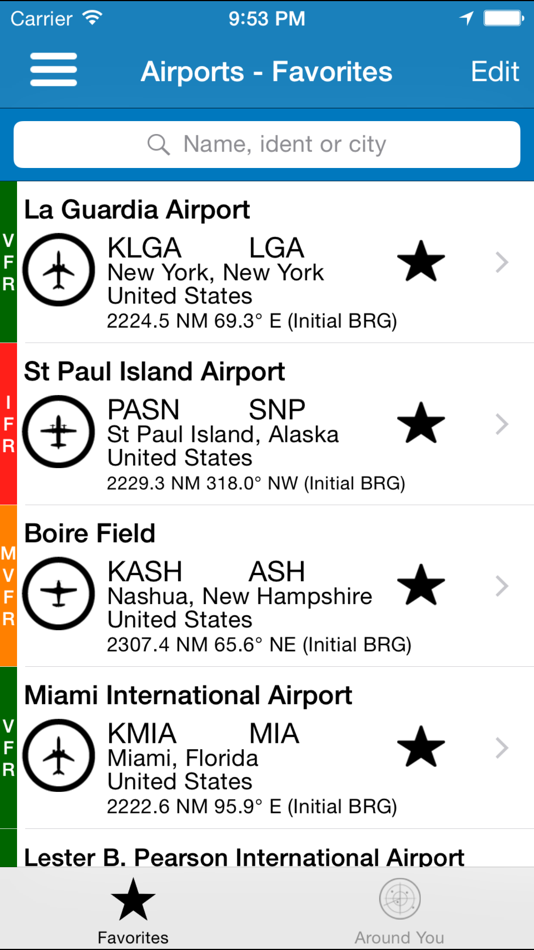
Airport data:
-Name, city, state, and country
-Local and ICAO identifiers.
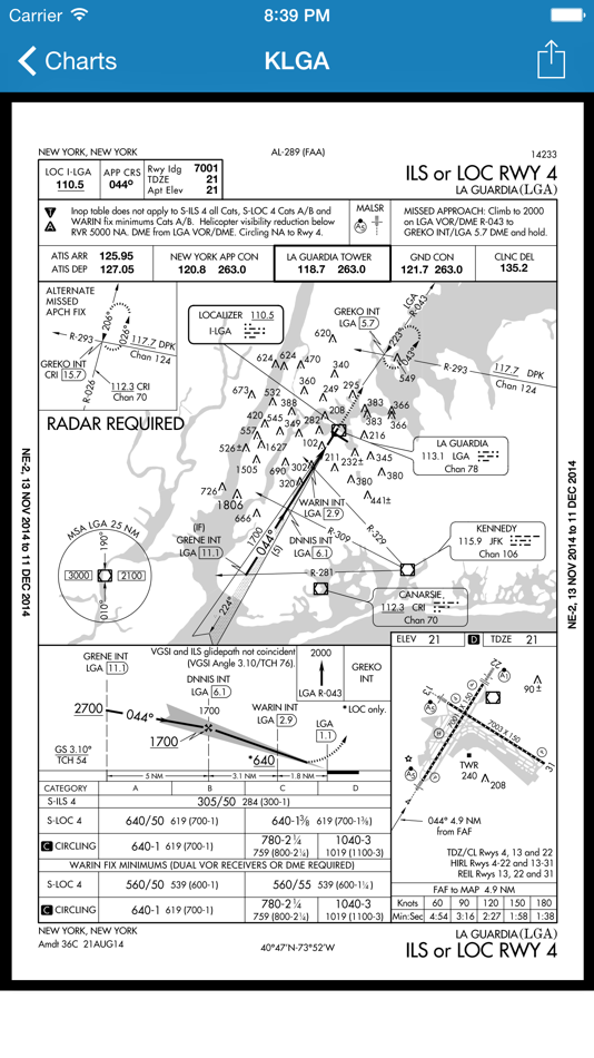
-FAA / NACO airport diagrams and instrument procedure charts.
-Coordinates.
-Radio frequencies.
-Runway info.
-Time zone
-Current local and Zulu (UTC) time.
-Sunrise/sunset/civil twilight times.
-METAR/ TAF weather reports.
-Color-coded weather dashboard for METAR supported airports.
-Notices to airmen (NOTAMs).
Navaid data:
-Type.
-Power output.
-location.
-Identifier (letters and Morse code).
-Time zone
-Current local and Zulu (UTC) time.
-Sunrise/sunset/civil twilight times.
User Agreement / Disclaimer:
AeroPointer relies on several 3rd party sources to provide you with aeronautical data. The information provided by this app cannot be guaranteed as accurate, up-to-date, or available at any given time.
The app should only be used for general reference, NOT for flight planning or navigation purposes.
The user is responsible for verifying the information before using it in the real world.
If you find any errors, please let us know to keep improving the database.
Enjoy!
螢幕擷取畫面


價錢
- 今天: 免費
- 最小值: 免費
- 最大值: 免費
追蹤票價
開發人員
- FLEMINGER MEDIA LLC
- 平台: iOS 應用程式 (5)
- 清單: 0 + 0
- 點數: 0 + 234 ¡
- 排名: 0
- 評測: 0
- 折扣: 0
- 影片: 0
- RSS: 訂閱
點數
未找到 ☹️
排名
未找到 ☹️
清單
未找到 ☹️
評測
成為第一個評論 🌟
其他資訊
你可能還喜歡
-
- Airport Distance Calculator
- iOS 應用程式: 地圖與導航 由: Oliver Brunsmann
- 免費
- 清單: 0 + 0 排名: 0 評測: 0
- 點數: 0 + 67 (4.5) 版本: 2.15.4 Airport Distance Calculator, designed specifically for pilots and travelers. Seamlessly calculate the distance (Great Circle) between any two airports worldwide with ease and ... ⥯
-
- airport-taxi driver
- iOS 應用程式: 地圖與導航 由: SHENYANG HIKING HOLIDAY TRAVEL CO., LTD.
- 免費
- 清單: 0 + 0 排名: 0 評測: 0
- 點數: 0 + 0 版本: 4.6.6910 airport-taxi driver strongly boosts driver s efficiency by offering them an intuitive and easy to use tool to earn money. With the auto dispatching system, drivers can secure more ... ⥯
-
- Aero App
- iOS 應用程式: 地圖與導航 由: National Geospatial-Intelligence Agency
- 免費
- 清單: 0 + 0 排名: 0 評測: 0
- 點數: 1 + 37 (3.4) 版本: 1.2502.845 The NGA Aeronautical Application (Aero App) is an Electronic Flight Bag (EFB) mobile application developed by and for the DOD and FAA flight crews. The Application provides flight ... ⥯
-
- Airport Pal
- iOS 應用程式: 地圖與導航 由: Digilog Corporation
- $3.99
- 清單: 0 + 0 排名: 0 評測: 0
- 點數: 0 + 0 版本: 2.0 This app downloads current database information from the internet and saves it on your device so you can search airports while out of range of cell phone service, The search engine ... ⥯
-
- Airport Runway Finder
- iOS 應用程式: 地圖與導航 由: Aviametrix, LLC
- $1.99
- 清單: 0 + 0 排名: 0 評測: 0
- 點數: 0 + 1 (5.0) 版本: 1.2 Runway Finder is a very handy, unique App for pilots. It is charting app which displays airports with the kind of runway surface you need for planning cross-country flights. For ... ⥯
-
- Nearest Airport
- iOS 應用程式: 地圖與導航 由: JONOTHON CONE
- $0.99
- 清單: 0 + 0 排名: 0 評測: 0
- 點數: 0 + 6 (3.0) 版本: 2.0.11 This standalone watch app allows GA pilots to locate quickly, nearby airports while in flight. Intuitive user interface provides the current distance from, the magnetic heading to, ... ⥯
-
- notams.aero
- iOS 應用程式: 地圖與導航 由: Ufuk Ugur
- * 免費
- 清單: 0 + 0 排名: 0 評測: 0
- 點數: 0 + 1 (1.0) 版本: 5.14 Notams Aero is the best NOTAM application. You can see NOTAMs on the map. Each NOTAM is displayed in categorized colors. Red means firing, yellow means training, blue means UAV, green ... ⥯
-
- Ibis Styles Amsterdam Airport
- iOS 應用程式: 地圖與導航 由: ISAA B.V.
- 免費
- 清單: 0 + 0 排名: 0 評測: 0
- 點數: 0 + 0 版本: 1.27.0 What to do in Amsterdam? Here you go! Get the city in your smartphone, and enjoy your stay like a local. City guide with all points of interest, and special venues selected by locals. ... ⥯
-
- Renaissance Amsterdam Airport
- iOS 應用程式: 地圖與導航 由: ML Hospitality Exploitatie Schiphol B.V.
- 免費
- 清單: 0 + 0 排名: 0 評測: 0
- 點數: 0 + 0 版本: 1.28.0 Renaissance Amsterdam Airport 100% detailed tourist map. GPS locator shows where you are and & where your chosen attraction is, including distance indication and navigation. Essential ... ⥯
-
- Steigenberger Adam Airport
- iOS 應用程式: 地圖與導航 由: STAG Hotels Netherlands B.V.
- 免費
- 清單: 0 + 0 排名: 0 評測: 0
- 點數: 0 + 0 版本: 1.37.0 What to do in Amsterdam? Here you go! Get the city in your smartphone, and enjoy your stay like a local. City guide with all points of interest, and special venues selected by locals. ... ⥯
-
- GPS Data – Coordinates & Speed
- iOS 應用程式: 地圖與導航 由: Oscar Fawkes
- 免費
- 清單: 0 + 0 排名: 0 評測: 0
- 點數: 0 + 458 (4.4) 版本: 1.4.1 GPS Data delivers all of the current location information available from your device, including GPS, compass, and barometer data. GPS Data displays the following information, in an ... ⥯
-
- GPS Data Smart
- iOS 應用程式: 地圖與導航 由: ExaMobile S.A.
- 免費
- 清單: 0 + 0 排名: 0 評測: 0
- 點數: 0 + 363 (4.7) 版本: 1.8 GPS Data app - you can check any necessary GPS data. If you like sports, mountaineering, journey, running you can use it to check your results or external parameters like speed, ... ⥯
-
- Map Data Explorer
- iOS 應用程式: 地圖與導航 由: Tech Maven GeoSpatial LLC
- 免費
- 清單: 0 + 0 排名: 0 評測: 0
- 點數: 0 + 1 (2.0) 版本: 1.5 Map Data Explorer is a advanced mapping app powered by vector tile basemaps (TMG OSM vector tiles, MapBox and others) with configurable stylesheets Supports user loaded device ... ⥯
-
- EUROCONTROL Data
- iOS 應用程式: 地圖與導航 由: Eurocontrol
- 免費
- 清單: 0 + 0 排名: 0 評測: 0
- 點數: 0 + 0 版本: 4.1.3 Keep up with the latest aviation data! Track key metrics: View traffic, ATFM delays, and punctuality metrics for the EUROCONTROL Network, individual States, top Aircraft Operators and ... ⥯