| 開發人員: | Tech Maven GeoSpatial LLC (9) | ||
| 價錢: | 免費 | ||
| 排名: | 0 | ||
| 評測: | 0 寫評論 | ||
| 清單: | 0 + 0 | ||
| 點數: | 0 + 1 (2.0) ¡ | ||
| App Store | |||
描述
")
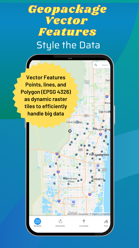
Supports user loaded device GeoJSON,Raster tiles from MBTILES and GPKG and vector tiles from MBTILES.
Supports user loaded Map Catalog (JSON) of internet mapping content (with catalog building screen)
XYZ PNG/JPG Raster Tiles
PBF Vector Tiles
GeoJSON
Local map tiles in mbtiles and gpkg
Includes additional layers users can enable:
vector overlays (Reference Grids, TimeZones and US State Boundaries)
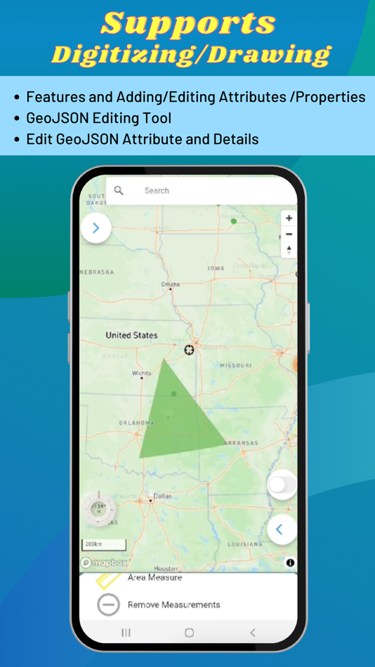
Draw/digitize vector data and support editing and assigning attributes.
Map Supports Tilting to display 3D terrain and 3D Buildings (only some basemaps support 3D buildings )
Currently, terrain is not available offline.
Map Tools:
- Search - places, addresses
- Advanced dynamic data collection forms with form builder
- Draw/Digitize Data Creation and Editing and export as GeoJSON
- Information Box for geojson data
- Measure linear and Area
- Geolocation & Coordinate Widget (Lat Long and MGRS and zoom level) and share location
- Go to Lat Long
- Placemarks (spatial bookmarks) (with import and export of Waypoints GeoJSON, KML and GPX)
- Basic Route Planning with import of Waypoints (KML and GPX)
- Connection to other Navigation Apps
- GPS Recorder with background recording and export or track
- View Spot Elevation
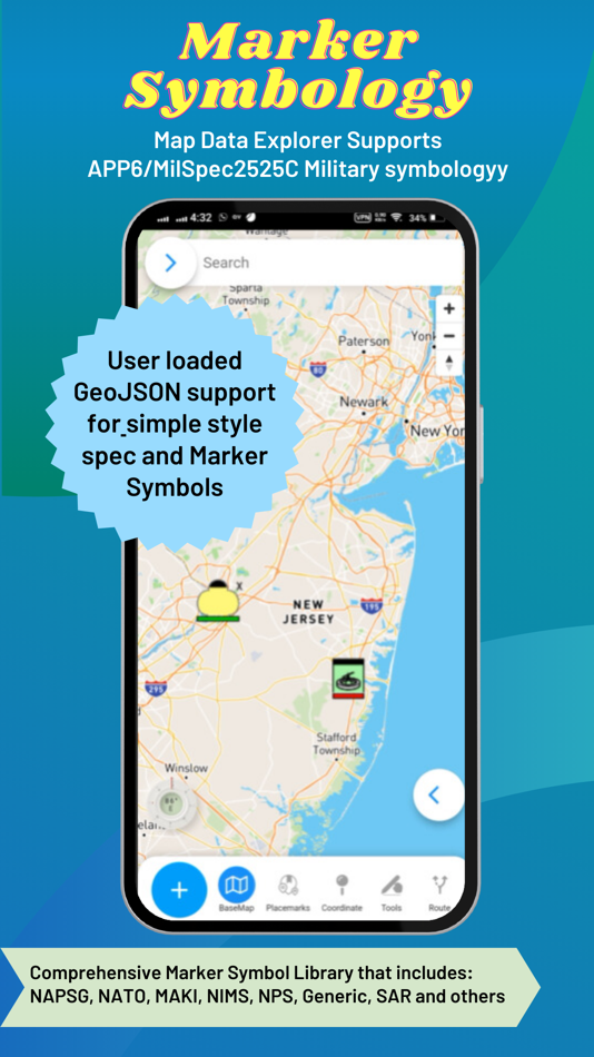
- Display Military Symbology (App6/MilSpec2525C) GeoJSON Schema easily shared with other apps
- Radius Ruler/Range Rings
- Coordinate Converter (to/from projected coordinates or geographic and GRIDS - MGRS, GARS, WHAT3WORD)
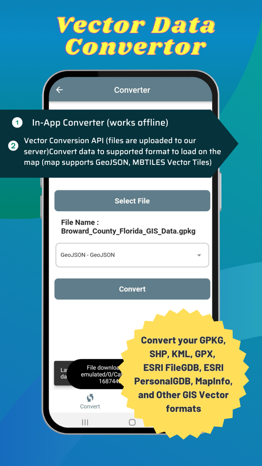
Includes an in-app vector converter to convert GIS data (Shapefiles, GPKG, GPX, KML, CSV, WKT to GeoJSON) must be 4326
Includes in-app coordinate converter to convert to /from different coordinate systems and GRIDS (MGRS,GARS, etc)
Wifi Sharing - access device files from web browser
File Manager To manage files
Create Forms with in-app or web form designer with JSON Schema
Load a form design and swap between forms
Collect any form data
Other features:
Vector Conversion and Publishing API to convert local vector GIS Data and also publish to PostGIS database tables.
Added Button links to TMG Map Data Explorer website for all in-app purchase screen
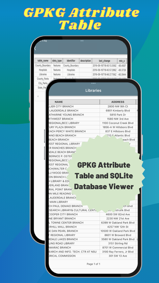
Serve OGC GPKG -GeoPackage with Vector Tiles new OGC extensions
Support for any SRS for raster tiles in GPKG (tested with 3857 and 3395)
Support for any SRS for Vector Tiles in GPKG (tested with 3857 and 3395)
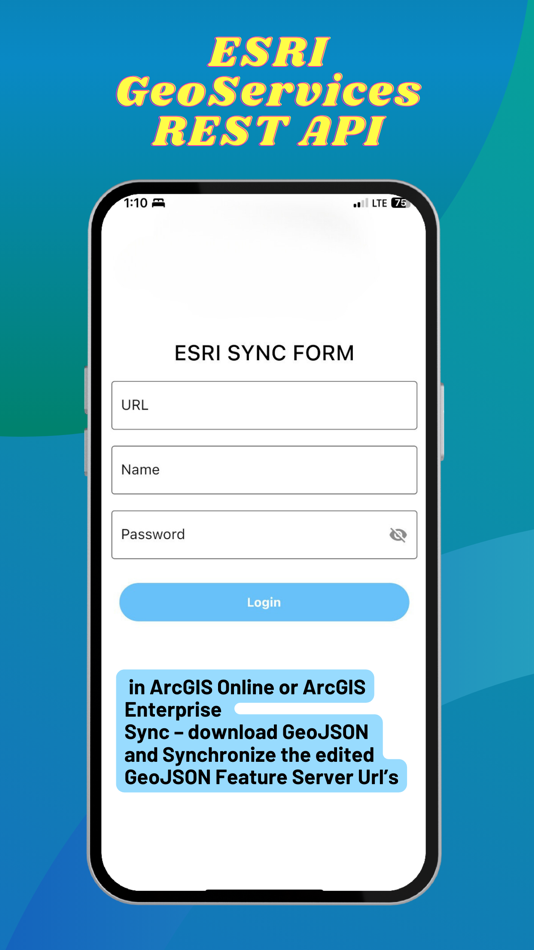
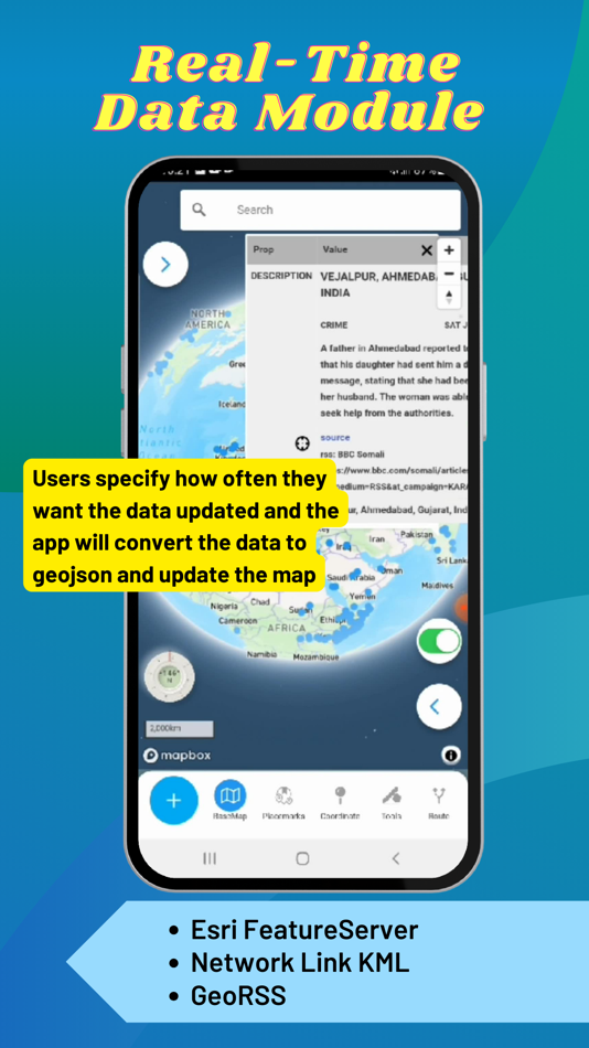
Real-Time Data Module (Network Link KML and Internet KML, ESRI GeoServices REST API and GeoRSS) display on the map and update at set frequency
Button to view attributes from GPKG Vector Features
2nd Non Map View – Office documents (Word, Excel, Powerpoint), PDF Viewer, EPUB Viewer, User links web pages and File Manager
User loaded GeoJSON support for simple style spec and Marker Symbols
ESRI GeoServices REST API (FeatureServer) in ArcGIS Online or ArcGIS Enterprise Sync – download GeoJSON and Synchronize edited GeoJSON.
Elevate API - submit geojson point and return back with Elevation, MGRS, GARS, What3Words, PlaceKey, Pluscode properties
GeoRequest Area of Interest API for submitting jobs for offline data
Pre-staged data downloading of ready to download data
Area of interest downloading of online map data:
Tile Downloader that supports building mbtiles from tile layers (XYZ/TMS, WMTS and Dynamic and cached mapping services (ESRI MapServer, ImageServer, OGC WMS) and downloading GeoJSON from WFS and MapServer and FeatureServer.
Terms of Use: https://mapexplorer.techmaven.net/eula/
螢幕擷取畫面


新功能
- 版本: 1.5
- 發佈日期:
- Mapbox V3 3D Basemap
WMS URL Loading
Image Server URL Loading
Map Server URL Loading
GeoJson Loading from URL
Overlays
Vector Dynamic Mapping Services
2.5 D indoor geo json 3d geojson
Geojson to attribute table
Stream Server
Load 3d tiles (Online Only)
Load 3d model GLB
Bug fixing
價錢
- 今天: 免費
- 最小值: 免費
- 最大值: 免費
追蹤票價
開發人員
- Tech Maven Geospatial, LLC
- 平台: iOS 應用程式 (8) Windows 應用程式 (1)
- 清單: 0 + 0
- 點數: 2 + 2 ¡
- 排名: 0
- 評測: 0
- 折扣: 0
- 影片: 0
- RSS: 訂閱
點數
未找到 ☹️
排名
未找到 ☹️
清單
未找到 ☹️
評測
成為第一個評論 🌟
其他資訊
聯絡人
你可能還喜歡
-
- Map Data Generator TilePackage
- iOS 應用程式: 地圖與導航 由: Tech Maven GeoSpatial LLC
- 免費
- 清單: 0 + 0 排名: 0 評測: 0
- 點數: 0 + 0 版本: 1.0 Provides ESRI Tile Package (VTPK and TPKX) Data products for use in ESRI ArcGIS Maps SDK (Runtime) Apps like ArcGIS Field Maps, Survey123, ArcGIS Mission Responser, ArcGIS Earth, ... ⥯
-
- Terra Map - Trail Explorer
- iOS 應用程式: 地圖與導航 由: GEC s.r.l.
- 免費
- 清單: 0 + 0 排名: 0 評測: 0
- 點數: 0 + 536 (4.6) 版本: 42.9 Enjoy every adventure safely with the best technology for outdoor navigation. Developed with the help of experienced hikers and bikers, Terra Map can meet all your needs. FEATURES: ... ⥯
-
- MineAR: Augmented Reality Map
- iOS 應用程式: 地圖與導航 由: Map Life, LLC
- * 免費
- 清單: 0 + 0 排名: 0 評測: 0
- 點數: 0 + 5 (5.0) 版本: 2.40.15 Data you can grasp. As a geoscience professional, we know you want an easier way to see your GIS data while you re in the field. MineAR allows you to do exactly that. Our app ... ⥯
-
- Memory-Map for All
- iOS 應用程式: 地圖與導航 由: Memory-Map
- 免費
- 清單: 0 + 0 排名: 0 評測: 0
- 點數: 0 + 9 (4.9) 版本: 1.3.1 Download maps for Offline GPS Navigation. No mobile data connection required. Your favorite maps and charts from OS, Hema, NOAA, and many more. Fully customizable map, data display and ⥯
-
- Map Switch: Open in any Map
- iOS 應用程式: 地圖與導航 由: Pavly Paules
- 免費
- 清單: 0 + 0 排名: 0 評測: 0
- 點數: 9 + 1 (5.0) 版本: 2.4.0 Map Switch - Open map links in your favourite map service Transform your map experience with Map Switch, the ultimate tool for converting between Apple Maps, Google Maps, Waze, Bing ... ⥯
-
- Map LT
- iOS 應用程式: 地圖與導航 由: Taylan Atasoy
- 免費
- 清單: 0 + 0 排名: 0 評測: 0
- 點數: 0 + 0 版本: 4.0 Map LT is a cutting-edge navigation and mapping application designed for users who want to easily find their way around World. With its user-friendly interface and comprehensive ... ⥯
-
- Map Map - Your Map on a Map
- iOS 應用程式: 地圖與導航 由: Ben Roberts
- * 免費
- 清單: 0 + 0 排名: 0 評測: 0
- 點數: 0 + 2 (5.0) 版本: 2.3 Welcome to Map Map Your Personal Cartographer! Ever wished you could see where you were on a trail map, building diagram, or any other visual reference? How about knowing where a trail ⥯
-
- Map MateAI- Navigate with Chat
- iOS 應用程式: 地圖與導航 由: Ahmet Erkin Arıkan
- 免費
- 清單: 0 + 0 排名: 0 評測: 0
- 點數: 0 + 0 版本: 1.0.3 Struggling to decide where to go? Let our app guide you! Whether you're searching for a cozy café, an exciting spot to explore, or a pharmacy on duty, we ve got you covered. Simply ... ⥯
-
- Map Tells...!
- iOS 應用程式: 地圖與導航 由: Yuriko Kimura
- 免費
- 清單: 0 + 0 排名: 0 評測: 0
- 點數: 0 + 0 版本: 3.4 "Map Tells...! is an app that shares your location with your companion by providing a Google Maps link and photo. The mail receiver follows the directions (on the map or through a ... ⥯
-
- Map It Realtour
- iOS 應用程式: 地圖與導航 由: DKP Productions LLC
- 免費
- 清單: 0 + 0 排名: 0 評測: 0
- 點數: 0 + 3 (5.0) 版本: 2.0.2 Map It Realtour® / Mobile Application for Realtors With New Map It Client Version for Their Clients Map It Realtour® is a new and unique Real Estate App for Agents worldwide, that was ... ⥯
-
- Map Tools
- iOS 應用程式: 地圖與導航 由: Modular Machines LLC
- $1.99
- 清單: 0 + 0 排名: 0 評測: 0
- 點數: 0 + 1 (5.0) 版本: 6.1 Map Tools supports coordinate systems and map projections for 232 datums, including WGS84, NAD27, NAD83, ED50, OSGB36, EGSA87, AGD66, AGD84, GDA94, NZGD2000, NZGD1949, and many more. ... ⥯
-
- Map Points
- iOS 應用程式: 地圖與導航 由: Sachin Deshpande
- $0.99
- 清單: 0 + 0 排名: 0 評測: 0
- 點數: 0 + 0 版本: 1.2 Map Points is an app to store your favorite map locations. You can use it while hiking to mark pinpoint locations that you want to remember. Or you can drop a pin to mark the secret ... ⥯
-
- Map Snapper
- iOS 應用程式: 地圖與導航 由: Mark Malone
- * 免費
- 清單: 0 + 0 排名: 0 評測: 0
- 點數: 0 + 0 版本: 2.1 Plan orienteering events by placing and fine tuning control locations in the field. Create your own instant offline maps. Create geolocated maps from photos and pictures, either with ... ⥯
-
- Map Plus
- iOS 應用程式: 地圖與導航 由: Miocool Inc.
- 免費
- 清單: 1 + 1 排名: 0 評測: 0
- 點數: 0 + 612 (4.6) 版本: 2.9.0 The most powerful and versatile tool for viewing and editing custom maps, surveying, editing or managing mass of your geography data. You can use Map Plus as a professional GIS tool ... ⥯