| Developer: | BaseMap Inc (2) | ||
| Price: | Free | ||
| Rankings: | 0 | ||
| Reviews: | 0 Write a Review | ||
| Lists: | 0 + 0 | ||
| Points: | 0 + 9,019 (4.6) ¡ | ||
| App Store | |||
Description
")
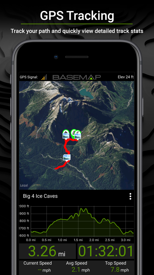
OFFLINE GPS and TRACKING
• Cache maps for offline use without service.
• Save as many offline maps as you want with unlimited caching (Pro).
• Know exactly where you are in real time even without cellular coverage.
MAP LAYERS
• 800+ layers
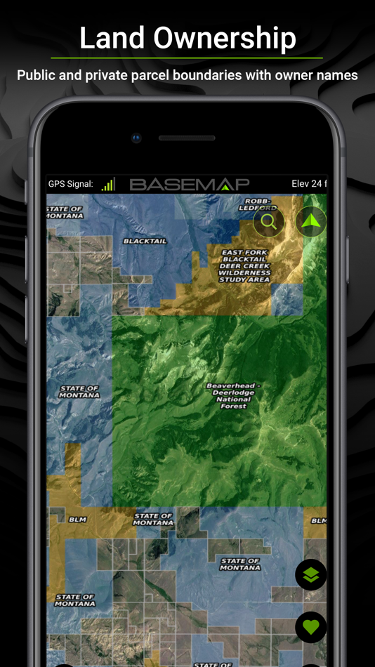
• Nationwide Color Coded Govt Lands
• Nationwide Private Parcel Boundaries & Owner Names
• Water depths for East coast, West, Coast, Gulf coast, 4,000+ U.S. lakes
• Nationwide Hiking Trails
• Nationwide Wildfires & Timber Cuts
• Nationwide Wilderness & Roadless Areas
• State specific hunting layers including hunting unit boundaries, private hunting opportunities, WMA’s & more
• Multiple TOPO & Satellite Imagery options
• Much more
MOBILE HUNT PLANNER
• Unit filtering
• Draw odds
• Harvest data
• Season dates
• Unit insights
IN-APP 3D SATELLITE IMAGERY
• As close to boots-on-the-ground as you can get
• Tilt & rotate the map to see the terrain from every angle
LRF MAPPING (Laser Rangefinder Mapping)
• Use your rangefinder as a powerful mapping tool
• Precisely mark the exact location of distant targets with ANY rangefinder
• Recover game, build routes, plan stalks, lookup distant property owners and more, all using your rangefinder!
MOBILE GPS
• Know your exact location even without cellular or WiFi service
• See where you are in relation to property boundaries, roads, trails, peaks, or boundaries
• Navigate to trail heads, favorite places, markers, or anything you need to locate with our powerful Search and GoTo features.
XDR (Exact Direction & Range) NAVIGATION
• Easy Point and Go navigation
• Know the exact distance between you and your destination.
HUNTWIND™ & WEATHER CENTER
• Wind forecast to better plan your hunt.
• Know the exact day and time to hunt a particular stand and visualize wind direction and scent drift in relation to your location.
• Forecasts, temperature, moon phase, sunrise/sunset, wind, and more.
LOCATION SHARING
• Know exactly where your hunting partner is located
• Real-time updates
OUTDOOR JOURNAL
• Capture, log, and share all your outdoor adventures with the BaseMap community
• Real-time location sharing so friends can see where you are in case of emergency (connection reqd.)
• SmartMarkers - Automatically capture the weather conditions at the time you add a marker.
HARVEST LOG
• Log your hunts as detailed as you'd like. Record your hunt type, species/size, weapon, unit/GMU & much more.
GOOGLE EARTH INTEGRATION
• Export markers and view them in Google Earth
• View terrain in true 3D
DESKTOP APPLICATION
• Automatically sync your data between your phone and the BaseMap web application.
SUBSCRIPTIONS
BASIC (Free)
• No Ads
• Connect with friends
• Hybrid 3D Imagery (map tilt).
• XDR Navigation
• Nationwide Roads, Trails & Points of Interest
• Nationwide Lakes, Rivers & Streams
• Hunting Unit boundaries
• GPS Location & Tracking
• Hi-Res Satellite Imagery
PRO ($39.99/yr)
• Everything in Basic plan
• Access to over 800 Layers
• Unlimited Data & Offline Use
• Nationwide parcel boundaries and owner names
• Nationwide color-coded government lands
• 3D Earth view (iOS)
• Google Earth Integration
• Import/Export KML and GPX with BaseMap web application
• Real-Time location sharing
• LRF Mapping (Laser Rangefinder Mapping)
PRO ADVANTAGE ($69.99/yr)
Includes:
• BaseMap Pro subscription
• Global Rescue subscription for field advisory and rescue services
PRO ULTIMATE ($99.99/yr)
Includes:
• BaseMap Pro subscription
• Global Rescue subscription for field advisory and rescue services
• Mobile Hunt Planner tools: Unit filtering, draw odds, harvest data, season dates, and more
For questions or more information, contact us at: support@basemap.com
Privacy policy: https://www.basemap.com/privacy-policy/
Terms of use: https://www.basemap.com/terms-of-use/
Screenshots


What's new
- Version: 6.2.0
- Updated:
- In this release, we are excited to bring our Partnership with LandTrust to our mobile app. LandTrust is your ultimate toolkit to hunt private land. With our mobile integration, you can view thousands of private land hunting and recreation opportunities right inside of BaseMap. Browse, book, and get up to 15% off private hunting access! You can find the LandTrust properties under the "Hunts" icon at the bottom of the map screen.
We have also fixed a couple bugs inside of the hunt planner, and made some small updates to map performance when first opening the app
Price History
- Today: Free
- Minimum: Free
- Maximum: Free
Track prices
Developer
- BaseMap Inc
- Platforms: Android Apps (1) iOS Apps (1)
- Lists: 0 + 0
- Points: 0 + 13,513 ¡
- Rankings: 0
- Reviews: 0
- Discounts: 0
- Videos: 1
- RSS: Subscribe
Points
0 ☹️
Rankings
0 ☹️
Lists
0 ☹️
Reviews
Be the first to review 🌟
Additional Information
- Version: 6.2.0
- Category:
iOS Apps›Navigation - OS:
iPad,iPhone,iOS 16.6 and up - Size:
337 Mb - Supported Languages:
English - Content Rating:
4+ - App Store Rating:
4.6(9,019) - Updated:
- Release Date:
Contacts
- Website:
 http://www.basemap.com
«BaseMap: Hunting GPS Maps» is a Navigation app for iOS, developed by «BaseMap Inc». It was first released on and last updated on . This app is currently free. This app has not yet received any ratings or reviews on AppAgg. On App Store, the current store rating is 4.6 based on 9,019 votes. Available languages: English. AppAgg continuously tracks the price history, ratings, and user feedback for «BaseMap: Hunting GPS Maps». Subscribe to this app or follow its RSS feed to get notified about future discounts or updates.
- 🌟 Share
- App Store
You may also like
-
- i-Hunting : GPS Maps App
- iOS Apps: Navigation By: Bist LLC
- * Free
- Lists: 0 + 0 Rankings: 0 Reviews: 0
- Points: 0 + 1,516 (4.4) Version: 114.0.0 This hunting GPS app provides access to property line maps, parcels & public lands, land ownership details. Map layers for 50+ states include hunting zones, restricted areas, possible ... ⥯
-
- Trucker Guide: Truck GPS Maps
- iOS Apps: Navigation By: Trucker Guide LLC
- Free
- Lists: 0 + 0 Rankings: 0 Reviews: 0
- Points: 0 + 6,979 (4.8) Version: 3.3.2 Trucker Guide the all-in-one GPS navigation tool developed specifically for commercial drivers. Whether you're hauling OTR or making local deliveries, Trucker Guide ensures you have ... ⥯
-
- Compass 55. Map & GPS kit.
- iOS Apps: Navigation By: Kalimex-Consulting s.r.o. @Blocoware & Stanislav Dvoychenko
- Free
- Lists: 1 + 0 Rankings: 0 Reviews: 0
- Points: 3 + 1,465 (4.7) Version: 5.2.3 All-in-one assistant with a map, compass, GPS coordinates to view and share in 6 formats, altitude, distance, sunset/sunrise, speedometer with top and average speed, navigator to your ... ⥯
-
- Offline gps maps: Mapy.com
- iOS Apps: Navigation By: Seznam.cz a.s.
- Free
- Lists: 0 + 0 Rankings: 0 Reviews: 0
- Points: 4 + 1,148 (4.8) Version: 6.61.0 PLAN YOUR ROUTE - hiking and cycling trails - cross-country skiing and ski-alpine trails - unique travel tips feature plans a trip through the most interesting places in the area - ... ⥯
-
- GPS Speedometer: Speed Tracker
- iOS Apps: Navigation By: Mikhail Nikitsin
- Free
- Lists: 0 + 0 Rankings: 0 Reviews: 0
- Points: 0 + 5,281 (4.5) Version: 1.8.0 GPS Speedometer is the most elegant and unique combination of speedometer and trip computer in one application. Just start the application and it will automatically record your speed, ... ⥯
-
- Hunting Points: Deer Hunt App
- iOS Apps: Navigation By: Fishing Points d.o.o.
- Free
- Lists: 0 + 0 Rankings: 0 Reviews: 0
- Points: 1 + 5,712 (4.6) Version: 1.8.8 Make the most of the next hunting season with Hunting Points. Welcome to the ultimate tool suitable for every hunter and outdoorsman. With features dedicated to enhancing your ... ⥯
-
- GPS & Maps: Location Tracker
- iOS Apps: Navigation By: Kraus und Karnath GbR 2Kit Consulting
- Free
- Lists: 0 + 0 Rankings: 0 Reviews: 0
- Points: 2 + 2,201 (4.4) Version: 4.3 GPS & Maps is a simple, yet powerful GPS app for supporting navigation and outdoor activities like geocaching, sailing, skating, trekking, biking or traveling by airplane. It measures ... ⥯
-
- GPS Speedometer, Speed Tracker
- iOS Apps: Navigation By: Nikhil Kumar
- Free
- Lists: 0 + 0 Rankings: 0 Reviews: 0
- Points: 0 + 23,660 (4.8) Version: 6.0.0 Track your speed with GPS accuracy using the ultimate GPS Speedometer & Odometer app. Whether you re driving a car, riding a bike, or hauling with a truck, this speed tracker gives you ⥯
-
- GPS Speedometer MPH Tracker
- iOS Apps: Navigation By: BITHAUS.TECH, UNIPESSOAL LDA
- Free
- Lists: 0 + 0 Rankings: 0 Reviews: 0
- Points: 1 + 11,262 (4.7) Version: 7.1.4 Transform every journey into valuable data with GPS Speedometer - the most comprehensive speed tracking app for driving, cycling, boating, and beyond. Experience professional-grade ... ⥯
-
- Organic Maps: Offline Map
- iOS Apps: Navigation By: Organic Maps
- Free
- Lists: 1 + 1 Rankings: 0 Reviews: 0
- Points: 3 + 901 (4.8) Version: 2025.11.11 Detailed offline maps with places that don't exist on other maps Cycling routes, hiking trails, and walking paths Contour lines, elevation profiles, peaks, and slopes Turn-by-turn ... ⥯
-
- CoPilot GPS Navigation
- iOS Apps: Navigation By: Trimble Maps Ltd.
- Free
- Lists: 0 + 0 Rankings: 0 Reviews: 0
- Points: 0 + 1,978 (3.5) Version: 10.28.2.391 Built for you, the driver. Whether you are behind the wheel of a car, a professional truck driver with profits tied to your time on the road or an RVer exploring the country - CoPilot ... ⥯
-
- GPS Navigation & Path Finder
- iOS Apps: Navigation By: Muhammad Asad Khan
- Free
- Lists: 0 + 0 Rankings: 0 Reviews: 0
- Points: 0 + 3,503 (4.6) Version: 8.1.0 This GPS Navigation and Route finder app provide a bunch of functionalities including finding exact route, Direction, Navigation, Nearby Places and many more with Voice functionality. ... ⥯
-
- Google Maps
- iOS Apps: Navigation By: Google
- Free
- Lists: 14 + 9 Rankings: 5 (3) Reviews: 5 (1)
- Points: 5 + 6,961,087 (4.7) Version: 25.47.0 Explore and navigate the world with confidence using Google Maps. Find the best routes with live traffic data and real-time GPS navigation for driving, walking, cycling, and public ... ⥯
-
- onX Hunt: GPS Hunting Maps
- iOS Apps: Navigation By: onXmaps, Inc.
- Free
- Lists: 0 + 0 Rankings: 0 Reviews: 0
- Points: 1 + 260,688 (4.9) Version: 25.45.0 Navigate your next hunt and view species distribution, topo maps, hunting units, and more. Whether you re a private or public land hunter, know where you stand with land ownership ... ⥯