| Developer: | Chris Hager (3) | ||
| Price: | * Free | ||
| Rankings: | 0 | ||
| Reviews: | 0 Write a Review | ||
| Lists: | 0 + 0 | ||
| Points: | 1 + 14 (4.0) ¡ | ||
| App Store | |||
Description
")
As a fisherman like you, I've always used NOAA charts for the Bay. Given how fast the environment changes, these are at best, unreliable and at worst, dangerous.
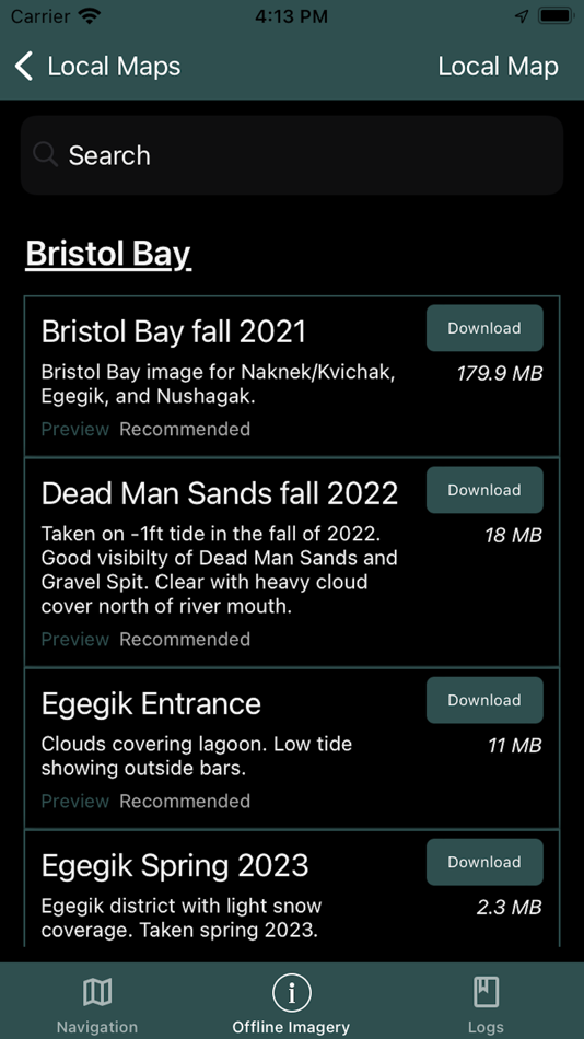
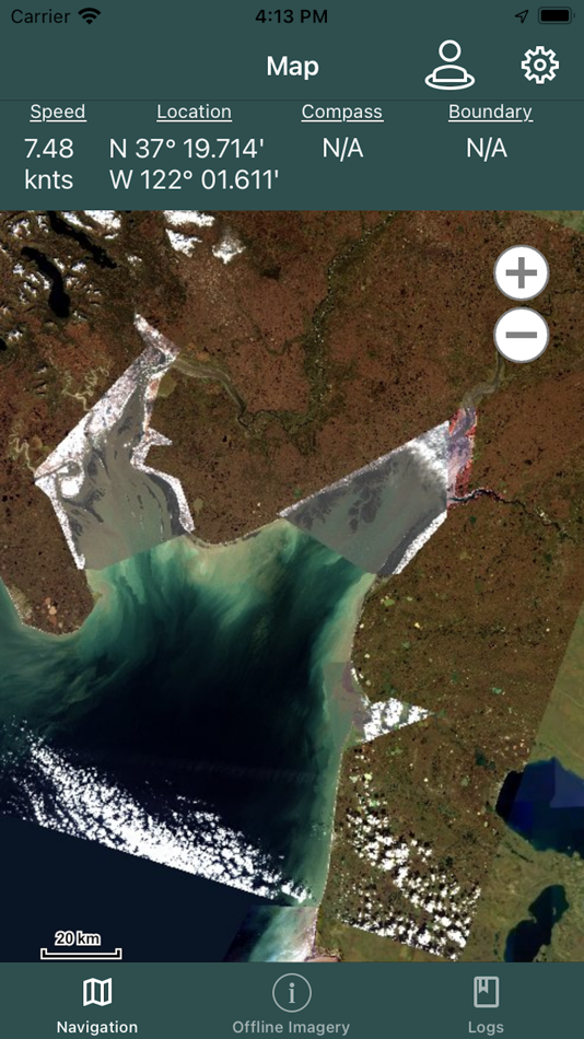
For this I developed Bristol Maps, an app that leverages curated satellite images taken during low tide, displaying the current bar locations, and allows for multiple images to be layered. For areas with multiple images at varying tides, this app allows you to see where there will, or won’t be navigable water. Additionally, these images can be overlayed onto the traditional NOAA charts.
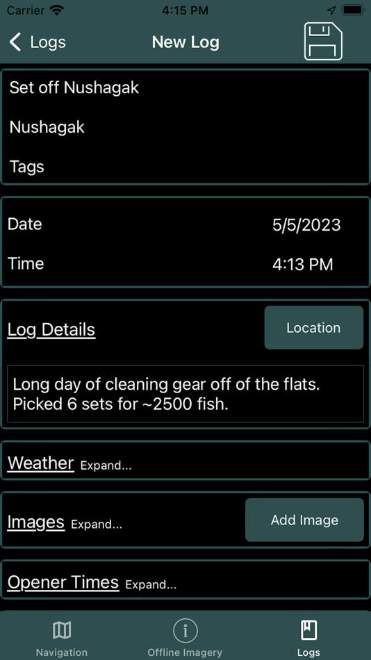
Beyond the core mapping functionality, tide and weather forecasts are also available. Weather can be pinpointed to a location as well as the nearest NOAA zone weather forecast. This information can be combined with the mapping functionality to create digital logs. Location, catch, weather, and tide data can be integrated into a log event. Logs can be overlaid onto the navigation page and analyzed to view catch data by area, gear type (4.75" vs 5"), and weather.
Feature list:
* Private groups for sharing location, custom routes and waypoints.
* Private group chat.
* Satellite overlays available for: Naknek/Kvichak, Egegik, Ugashik, Nushagak, and Copper River. Updated seasonally.
* NOAA overlays available offline for all of Alaska.
* Location grid layouts, organized by color and number, which can replace traditional paper maps or code tables shared by Groups. ie: "I'm over by green 22." A search tool is included to quickly find locations.
* NOAA tide charts available offline for Bristol Bay tide stations. Other locations downloaded as they are used.
* Pinpoint weather forecasts available as well as NOAA zone weather forecasts.
* Boundary lines (with “alarm” functionality), for all major districts are preprogrammed along with the ability to create new boundaries.
* Create Waypoints and Routes. These can also be exported/imported to/from other users to share data.
* Online maps can be streamed with NOAA charts, custom satellite views, a high-res AK Government view, and street view.
* Log entries for recording opener times, district, pictures, sets/deliveries, and automatic tide/weather history.
Bristol Maps has been designed with an intuitive, user friendly interface to solve a common fisherman problem.
Bristol Maps Pricing $150/Year
A two-week free trial is included for testing and includes free cancellation. Subscription includes updates, bug fixes and seasonal imagery additions.
Screenshots
What's new
- Version: 3.13.1
- Updated:
- New navigation layout
Updated Weather detail page
New map download system
New Startup Option selection for maps, boundaries, announcements
Bug fixes
Price History
-
* In-App Purchases - Today: Free
- Minimum: Free
- Maximum: Free
Track prices
Developer
- Chris Hager
- Platforms: iOS Apps (3)
- Lists: 0 + 0
- Points: 1 + 15 ¡
- Rankings: 0
- Reviews: 0
- Discounts: 0
- Videos: 0
- RSS: Subscribe
Points
-

- 14,754 Lance Eliakim Sotto
- +1

Rankings
0 ☹️
Lists
0 ☹️
Reviews
Be the first to review 🌟
Additional Information
- Version: 3.13.1
- Category:
iOS Apps›Navigation - OS:
iPad,iPhone,iOS 13.0 and up - Size:
413 Mb - Content Rating:
4+ - App Store Rating:
4.0(14) - Updated:
- Release Date:
Contacts
- Website:
 https://bristolmaps.com
«Bristol Maps» is a Navigation app for iOS, developed by «Chris Hager». It was first released on and last updated on . This app is currently free. This app has not yet received any ratings or reviews on AppAgg. AppAgg has tracked 1 confirmed points plus 14 indirect points for this app. On App Store, the current store rating is 4.0 based on 14 votes. AppAgg continuously tracks the price history, ratings, and user feedback for «Bristol Maps». Subscribe to this app or follow its RSS feed to get notified about future discounts or updates.
- 🌟 Share
- App Store
You may also like
-
- maps.earth
- iOS Apps: Navigation By: Michael Kirk
- Free
- Lists: 0 + 0 Rankings: 0 Reviews: 0
- Points: 0 + 4 (3.5) Version: 1.13 Explore the world and get low stress directions powered by OpenStreetMap. maps.earth is built on open source. We never show you ads or sell your data. We just want a nice map. ⥯
-
- Maps My Location
- iOS Apps: Navigation By: Rohit Bhayani
- Free
- Lists: 0 + 0 Rankings: 0 Reviews: 0
- Points: 0 + 1 (1.0) Version: 1.0 A Map My Location app for iOS is a software application designed to assist You in navigating from one location to another using the Global Positioning System (GPS) technology. Key ... ⥯
-
- Maps Address Book
- iOS Apps: Navigation By: Clever Thinking Software Inc.
- * Free
- Lists: 0 + 0 Rankings: 0 Reviews: 0
- Points: 0 + 11 (4.8) Version: 1.23 Maps Address Book: Your Complete Address Management Solution Tired of hunting for addresses across multiple map apps? Maps Address Book is the ultimate solution for managing all your ... ⥯
-
- Bristol Tour Map of Banksy
- iOS Apps: Navigation By: Stephen Kempin
- $0.99
- Lists: 0 + 1 Rankings: 0 Reviews: 0
- Points: 1 + 2 (3.0) Version: 2.0.10 A Bristol native, graffiti artist Banksy has acquired worldwide fame for his thought provoking and satirical street art, and several original pieces remain in various locations around ... ⥯
-
- Maps 3D PRO - Hike & Bike
- iOS Apps: Navigation By: movingworld GmbH
- $3.99
- Lists: 1 + 4 Rankings: 0 Reviews: 0
- Points: 0 + 201 (4.4) Version: 6.8 Enjoy exploring the great outdoors? If you re a fan of biking, hiking and running then Maps 3D is the ideal app designed for planning your outdoor adventures. Whereas other mapping ... ⥯
-
- Organic Maps: Offline Map
- iOS Apps: Navigation By: Organic Maps
- Free
- Lists: 1 + 1 Rankings: 0 Reviews: 0
- Points: 3 + 1,013 (4.8) Version: 2025.12.16 Organic Maps is a fast, detailed offline map and GPS navigation app for travel, hikes, and rides. Plan, import, and record routes, and enjoy smooth guidance without draining your ... ⥯
-
- Maps TV
- iOS Apps: Navigation By: Anass Damri
- $0.99
- Lists: 0 + 0 Rankings: 0 Reviews: 0
- Points: 0 + 0 Version: 1.1 Transform your TV into a powerful mapping experience with Maps TV the ultimate navigation app designed specifically for the big screen. KEY FEATURES: Full Screen Map Experience: Enjoy ... ⥯
-
- Maps Anywhere: Offline GPS
- iOS Apps: Navigation By: Ali Mert TUFEKCI
- Free
- Lists: 0 + 0 Rankings: 0 Reviews: 0
- Points: 5 + 2 (5.0) Version: 1.0.0.8 SecureTrek Maps Anywhere - Stay Oriented in the Wild Every year, thousands of people get lost while trekking or exploring the outdoors due to poor visibility, disorientation, or losing ⥯
-
- Goat Maps
- iOS Apps: Navigation By: Goat Maps, inc.
- Free
- Lists: 0 + 0 Rankings: 0 Reviews: 0
- Points: 0 + 48 (4.7) Version: 2025.11 Goat Maps is the next-generation navigation app designed for outdoor adventures. Built from the ground up in 2024, Goat Maps offers unmatched reliability and ease of use, perfect for ... ⥯
-
- Maps & GPS: Route Finder
- iOS Apps: Navigation By: Bansari Sheladiya
- Free
- Lists: 0 + 0 Rankings: 0 Reviews: 0
- Points: 0 + 0 Version: 1.2 Your complete map, navigation, and travel assistant all in one powerful app. Maps & GPS: Route Finder is designed for travelers, explorers, and daily commuters who want accurate ... ⥯
-
- Blue Light Maps
- iOS Apps: Navigation By: Blue Light Maps
- * Free
- Lists: 0 + 0 Rankings: 0 Reviews: 0
- Points: 0 + 0 Version: 2025.12.13 Navigate smarter and arrive faster with BlueLight Maps the navigation app built for the frontline, by the frontline. Specifically designed for police, EMTs, firefighters and private ... ⥯
-
- Maps And Navigation
- iOS Apps: Navigation By: Varsha Patel
- * Free
- Lists: 0 + 0 Rankings: 0 Reviews: 0
- Points: 0 + 0 Version: 6.0 MapsAndNavigation App is a powerful and user-friendly tool designed to assist individuals in navigating their way through various locations with precision and ease. Best road trip ... ⥯
-
- Goose Maps for Watch
- iOS Apps: Navigation By: GOOSE MAPS LTD
- Free
- Lists: 0 + 0 Rankings: 0 Reviews: 0
- Points: 0 + 291 (4.1) Version: 1.3.2 Features - Navigate easily everywhere Our pedestrian and bike navigation perfectly work even if your iPhone stayed at home. - Search objects you need Our search helps you to find ... ⥯
-
- Pacenote Maps
- iOS Apps: Navigation By: Pacenote Maps LLC
- Free
- Lists: 0 + 0 Rankings: 0 Reviews: 0
- Points: 0 + 1 (5.0) Version: 1.10 Pacenote is a map and navigation app that lets you generate drives with AI. Discover scenic canyon roads, touge-style mountain passes, or relaxed coastal routes What you can do: ... ⥯