| 개발자: | XTools Pro, Inc (1) | ||
| 가격: | 무료 | ||
| 순위: | 0 | ||
| 리뷰: | 0 리뷰 작성 | ||
| 목록: | 0 + 0 | ||
| 포인트: | 0 + 88 (4.4) ¡ | ||
| App Store | |||
기술
")
It is designed to work with maps in a specific mobile format CMF2. To export your ArcGIS maps to this format, use CarryMap Builder, an extension to ArcGIS Desktop.
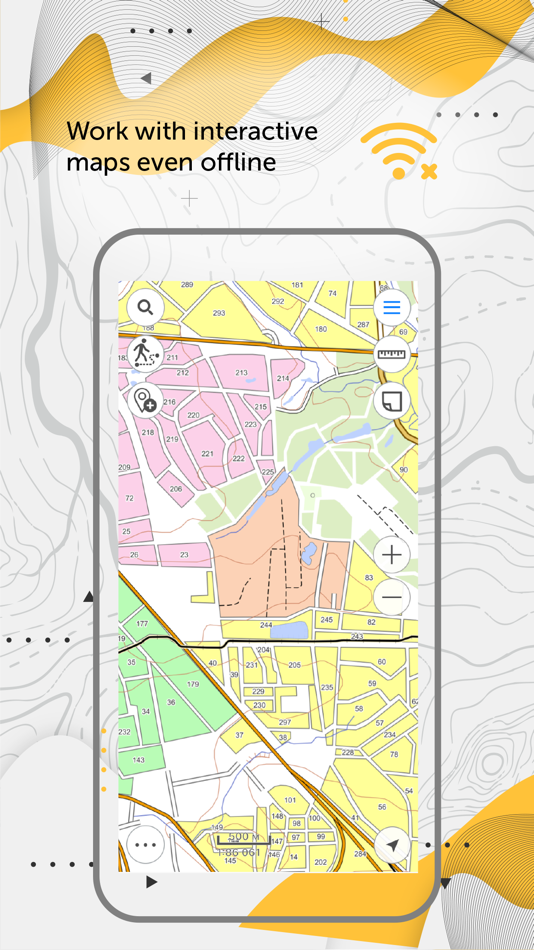
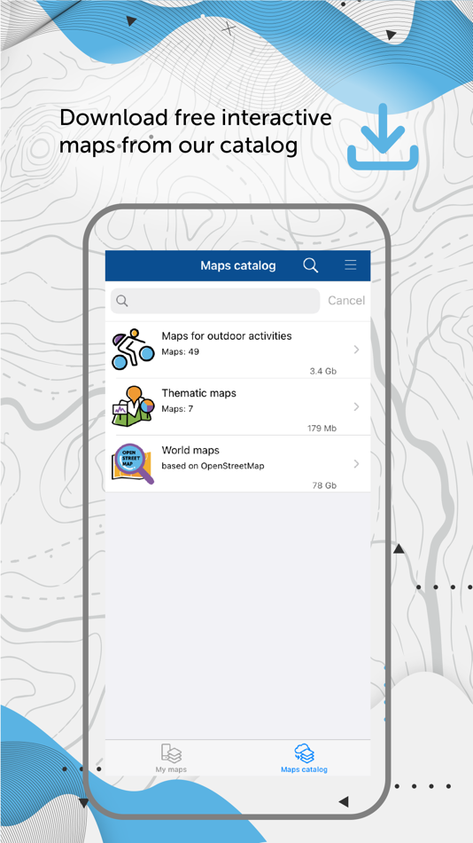
Maps management
- Download maps of only needed areas and store them in a convenient catalog. The maps provided in the catalog were created based on OpenStreetMap data.
- Upload your own maps prepared in ArcGIS and work with them offline.
- Use reliable methods for your maps protection.
- Create fully functional projects for work with all the needed information.
- Save selected map areas as bookmarks.
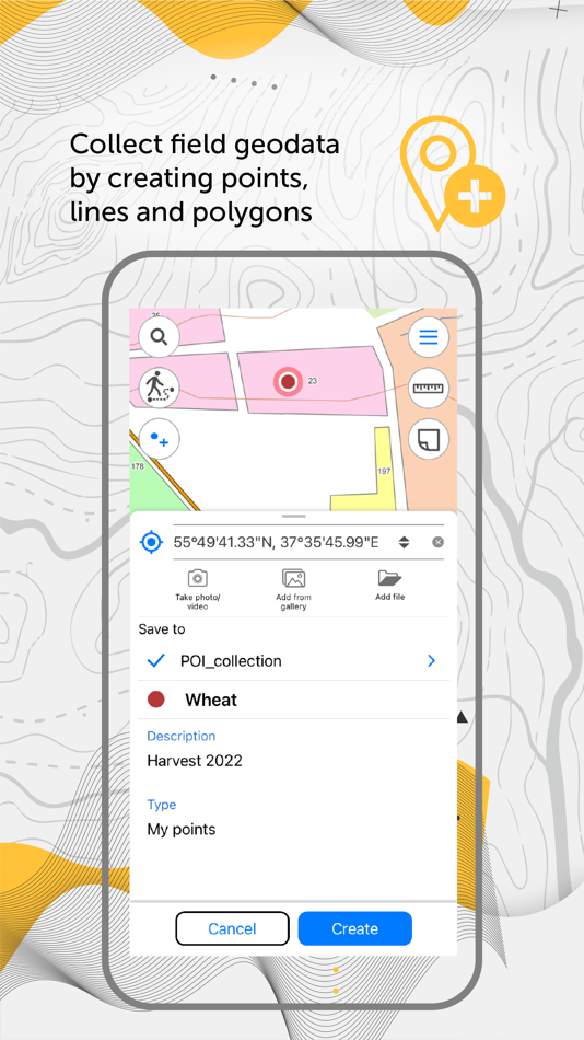
Working with objects
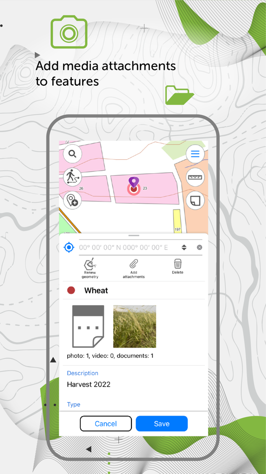
- Create and edit point, line, and polygon features on the map.
- Add media attachments (photo, video and documents) to features.
- Record voice comments when creating and describing features on the map.
- Create points on-the-fly using your device camera.
- Create points on the map with a single tap while moving, add description later if needed.
- Add graphic marks as text, arrows or free hand graphic.
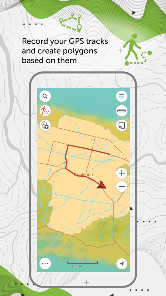
GPS tracks and navigation
- Use external Bad Elf GPS receiver to find your current location.
- Save tracks automatically without being distracted by editing them as you go.
- Use features on the map as landmarks or destination points on your route.
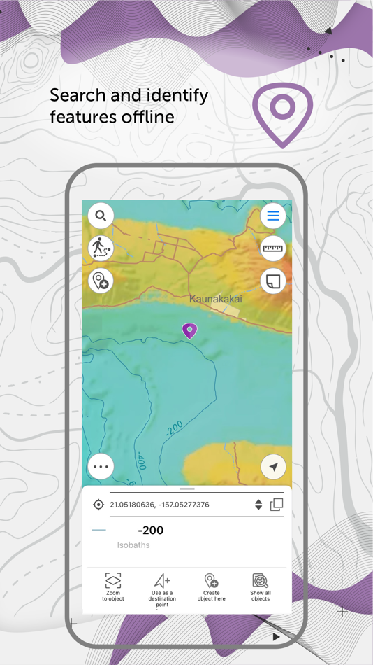
- Search and identify features offline.
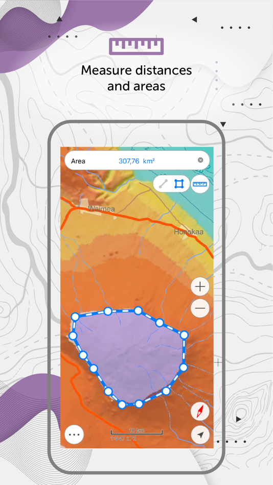
- Measure distances and areas.
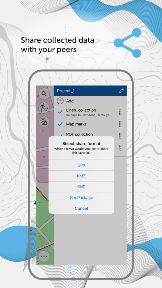
Data export
- Share coordinates of features on the map by sending a file or a link.
- Upload maps in MBTILES* formats.
- Share collected data in GPKG (GeoPackage), GPX, KML/KMZ and SHP formats.
*Maps in MBTILES format with raster tile type only are supported.
The application is accessible to a wide range of users, regardless of GIS skills, and can be used in various fields, including electrical energy industry, agriculture, geology and geodesy, housing and utility, environmental protection, water and land resources management, ecology and incident management, urban management, etc.
Take the opportunity to create your own branded application for viewing and working with mobile maps based on CarryMap for your company. Read more: https://carrymap.com/en/features/branding/
Read more about all the capabilities of CarryMap Builder extension at https://builder.carrymap.com/en/
To learn more about CarryMap application, visit https://carrymap.com/en/overview/
Watch educational videos on our YouTube page:
https://www.youtube.com/c/CarryMap/videos
Your questions or comments are welcome at support@xtools.pro
스크린샷
새로운 기능
- 버전: 7.1
- 업데이트:
- Thank you for using CarryMap app!
What’s new:
* Automatic saving of all tracks recorded by the app to the track log.
* Creating lines and polygons using freehand lines.
* Built-in ability to copy data files from the device memory.
* Preview for video attachments.
* New symbols for point features on the map.
* Fixes addressing overall stability and performance.
가격
- 오늘: 무료
- 최소: 무료
- 최대: 무료
가격 추적
개발자
- XTools Pro, Inc
- 플랫폼: iOS 앱 (1)
- 목록: 0 + 0
- 포인트: 0 + 88 ¡
- 순위: 0
- 리뷰: 0
- 할인: 0
- 동영상: 0
- RSS: 구독
포인트
0 ☹️
순위
0 ☹️
목록
0 ☹️
리뷰
첫 번째 리뷰를 남겨보세요 🌟
추가 정보
주소록
- 웹사이트:
 https://carrymap.com/en/
- 🌟 공유하기
- App Store
당신은 또한 같은 수 있습니다
-
- MineAR: Augmented Reality Map
- iOS 앱: 내비게이션 게시자: Map Life, LLC
- * 무료
- 목록: 0 + 0 순위: 0 리뷰: 0
- 포인트: 0 + 5 (5.0) 버전: 2.40.15 Data you can grasp. As a geoscience professional, we know you want an easier way to see your GIS data while you re in the field. MineAR allows you to do exactly that. Our app ... ⥯
-
- Map LT
- iOS 앱: 내비게이션 게시자: Taylan Atasoy
- 무료
- 목록: 0 + 0 순위: 0 리뷰: 0
- 포인트: 0 + 0 버전: 4.0 Map LT is a cutting-edge navigation and mapping application designed for users who want to easily find their way around World. With its user-friendly interface and comprehensive ... ⥯
-
- Map Map - Your Map on a Map
- iOS 앱: 내비게이션 게시자: Ben Roberts
- * 무료
- 목록: 0 + 0 순위: 0 리뷰: 0
- 포인트: 0 + 2 (5.0) 버전: 2.3 Welcome to Map Map Your Personal Cartographer! Ever wished you could see where you were on a trail map, building diagram, or any other visual reference? How about knowing where a trail ⥯
-
- Memory-Map for All
- iOS 앱: 내비게이션 게시자: Memory-Map
- 무료
- 목록: 0 + 0 순위: 0 리뷰: 0
- 포인트: 0 + 9 (4.9) 버전: 2.0.5 Download maps for Offline GPS Navigation. No mobile data connection required. Your favorite maps and charts from OS, Hema, NOAA, and many more. Immersive 3D World map view Fully ... ⥯
-
- Map MateAI- Navigate with Chat
- iOS 앱: 내비게이션 게시자: Ahmet Erkin Arıkan
- 무료
- 목록: 0 + 0 순위: 0 리뷰: 0
- 포인트: 0 + 0 버전: 1.0.3 Struggling to decide where to go? Let our app guide you! Whether you're searching for a cozy café, an exciting spot to explore, or a pharmacy on duty, we ve got you covered. Simply ... ⥯
-
- Map Tells...!
- iOS 앱: 내비게이션 게시자: Yuriko Kimura
- 무료
- 목록: 0 + 0 순위: 0 리뷰: 0
- 포인트: 0 + 0 버전: 3.4 "Map Tells...! is an app that shares your location with your companion by providing a Google Maps link and photo. The mail receiver follows the directions (on the map or through a ... ⥯
-
- Map It Realtour
- iOS 앱: 내비게이션 게시자: DKP Productions LLC
- 무료
- 목록: 0 + 0 순위: 0 리뷰: 0
- 포인트: 0 + 3 (5.0) 버전: 2.0.2 Map It Realtour® / Mobile Application for Realtors With New Map It Client Version for Their Clients Map It Realtour® is a new and unique Real Estate App for Agents worldwide, that was ... ⥯
-
- Map Tools
- iOS 앱: 내비게이션 게시자: Modular Machines LLC
- $1.99
- 목록: 0 + 0 순위: 0 리뷰: 0
- 포인트: 0 + 1 (5.0) 버전: 6.1 Map Tools supports coordinate systems and map projections for 232 datums, including WGS84, NAD27, NAD83, ED50, OSGB36, EGSA87, AGD66, AGD84, GDA94, NZGD2000, NZGD1949, and many more. ... ⥯
-
- Map Points
- iOS 앱: 내비게이션 게시자: Sachin Deshpande
- $0.99
- 목록: 0 + 0 순위: 0 리뷰: 0
- 포인트: 0 + 0 버전: 1.2 Map Points is an app to store your favorite map locations. You can use it while hiking to mark pinpoint locations that you want to remember. Or you can drop a pin to mark the secret ... ⥯
-
- Map Snapper
- iOS 앱: 내비게이션 게시자: Mark Malone
- * 무료
- 목록: 0 + 0 순위: 0 리뷰: 0
- 포인트: 0 + 0 버전: 2.1 Plan orienteering events by placing and fine tuning control locations in the field. Create your own instant offline maps. Create geolocated maps from photos and pictures, either with ... ⥯
-
- Map Link Converter
- iOS 앱: 내비게이션 게시자: POORNA S JAYASINGHE
- $4.99
- 목록: 0 + 0 순위: 0 리뷰: 0
- 포인트: 0 + 0 버전: 1.0 Seamlessly open any map link in your preferred navigation app. Map Link Converter is the ultimate tool for converting and opening map URLs across different mapping platforms. Whether ... ⥯
-
- Map Plus
- iOS 앱: 내비게이션 게시자: Miocool Inc.
- 무료
- 목록: 1 + 1 순위: 0 리뷰: 0
- 포인트: 0 + 615 (4.6) 버전: 2.9.0 The most powerful and versatile tool for viewing and editing custom maps, surveying, editing or managing mass of your geography data. You can use Map Plus as a professional GIS tool ... ⥯
-
- Map Paint
- iOS 앱: 내비게이션 게시자: Kouichi INAFUKU
- $0.99
- 목록: 1 + 0 순위: 0 리뷰: 0
- 포인트: 1 + 0 버전: 1.0.1 It is an application that you can paint on the map Note The position of the map may shift slightly when reloading the saved data The map when edited is slightly different from the ... ⥯
-
- Map Ruler - Distance Measure
- iOS 앱: 내비게이션 게시자: Sergey Irgeshov
- 무료
- 목록: 0 + 0 순위: 0 리뷰: 0
- 포인트: 0 + 13 (3.9) 버전: 2.0.1 Measure the distance traveled, plot your running route, calculate the area on the map, and much more! The application is convenient to use, as there is nothing superfluous in it, so ... ⥯