| ผู้พัฒนา: | JOMO Solutions Ltd (17) | ||
| ราคา: | $1.99 | ||
| การจัดอันดับ: | 0 | ||
| ความเห็น: | 0 เขียนความเห็น | ||
| รายการ: | 0 + 0 | ||
| แต้มแล: | 0 + 0 ¡ | ||
| App Store | |||
คำอธิบาย
")
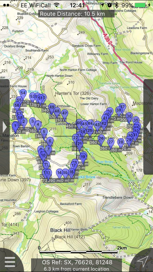
Beautifully detailed maps supplied by Ordnance Survey.
Dartmoor Maps provides a useful offline (no mobile signal required) mapping reference and navigation aid whilst travelling throughout the Dartmoor area by footpath, road, rail, canal, lake and river. Intuitive route and waypoint management features are implemented enabling creation, modification, deletion, import and export of routes. A powerful offline search facility can locate places, roads, post codes and hills within the region. Worldwide online Apple Maps (Standard, Satellite and Hybrid) with map features that users are used to are available on both offline and online maps as well as providing 3D buildings on Apple maps (where available).
Maps
7 different levels of offline 2014/2015 Ordnance Survey map detail from national overview to street view within the region. (No data connection required)
Progressively more detailed maps are automatically loaded as the map view is zoomed. The OS recommended viewing scales for the more detailed maps are approximately as follows:
1:1000,000 (The whole of GB is covered at this map scale)
1:250,000
1:50,000
1:25,000
1:10,000 ( (Roads/streets are labelled by name))
The map region of the more detailed maps covers a rectangular region around the national park boundary, (ref. http://jomosolutions.com/Maps)
- Contours with height information and annotated height points.
- Extensive footpaths from ©OpenStreetMap contributors
- National Park boundary demarkation
App
- Route/Waypoint management
- Offline search functionality with searchable locations (places, roads, post codes and hills). (For the place search a location's latitude and longitude is accurate to 0.1 of a minute of the centre point of the 1x1 km National Grid square in which the name falls)
- Detailed hill information, including height, OS Grid Ref, latitude and longitude, region, parent, classification, drop and hill specific links to Streetmap, Geograph and Hill Bagging web sites
- Display of current GPS position as OS Grid Reference or WGS84 latitude and longitude
- "Share My Location" allowing users to share an image of their current location and location references. Buttons are provided to share location information by Facebook, Twitter, iMessage/SMS and e-mail
- Online access to worldwide Apple Standard, Satellite and Hybrid maps
- Apple 3D Buildings are displayed on Apple Standard maps
- Apple maps contain Points of Interest
- User location can be tracked with or without heading on all online and offline maps (GPS capable devices only)
- Display of scale bar in either metric or imperial units
- Display of current speed
- Zoom, pan, rotation of all maps
- Pitch of Apple Standard and Ordnance Survey maps
- Selection of current location annotation for display of speed and location data
- User setting for speed display in Miles per Hour (mph) or Kilometres per Hour (kph)
- Selection of search result pin annotations to display location information
- Collective deletion of search result annotation pins
- A user guide is provided within the app information
The search data was published by Ordnance Survey in 2014 and
extracts from "The Database of British and Irish Hills" v14 published 22/04/2014 (ref. http://www.hills-database.co.uk/index.html )
No warranty
The data is supplied by Apple, Ordnance Survey, contributors to OpenStreetMap and Database of British and Irish Hills.
The Information is licensed 'as is' and the Information Provider and/or Licensor excludes all representations, warranties, obligations and liabilities in relation to the Information to the maximum extent permitted by law.
The Information Provider and/or Licensor are not liable for any errors or omissions in the Information and shall not be liable for any loss, injury or damage of any kind caused by its use.
This app is not a substitute for a paper map and compass.
ภาพหน้าจอ


มีอะไรใหม่
- เวอร์ชัน: 2.1.1
- อัปเดต:
- Fixed intermittent failures within the search functionality.
If you like the app please leave an app review.
ราคา
- วันนี้: $1.99
- ต่ำสุด: $1.99
- มากที่สุด: $1.99
ติดตามราคา
ผู้พัฒนา
- JOMO Solutions Ltd
- แพลตฟอร์ม: iOS แอป (17)
- รายการ: 1 + 1
- แต้มแล: 0 + 16 ¡
- การจัดอันดับ: 0
- ความเห็น: 0
- ลดราคา: 0
- วิดีโอ: 0
- RSS: ติดตาม
แต้มแล
0 ☹️
การจัดอันดับ
0 ☹️
รายการ
0 ☹️
ความเห็น
แสดงรีวิวเป็นคนแรกเลย 🌟
ข้อมูลเพิ่มเติม
- เวอร์ชัน: 2.1.1
- หมวดหมู่:
iOS แอป›การนำทาง - ระบบปฏิบัติการ:
Apple Watch,iPad,iPhone,iOS 8.0 และสูงกว่า - ขนาด:
345 Mb - ภาษาที่สนับสนุน:
English - การจัดประเภทเนื้อหา:
4+ - App Store คะแนนโดย:
0 - อัปเดต:
- วันที่วางจำหน่าย:
รายชื่อติดต่อ
- เว็บไซท์:
 http://jomosolutions.com/Maps/
- 🌟 แชร์
- App Store
คุณอาจชอบ
-
- Organic Maps: Offline Map
- iOS แอป: การนำทาง โดย: Organic Maps
- ฟรี
- รายการ: 1 + 1 การจัดอันดับ: 0 ความเห็น: 0
- แต้มแล: 3 + 979 (4.8) เวอร์ชัน: 2025.11.26 Organic Maps is a fast, detailed offline map and GPS navigation app for travel, hikes, and rides. Plan, import, and record routes, and enjoy smooth guidance without draining your ... ⥯
-
- Avenza Maps: Offline Mapping
- iOS แอป: การนำทาง โดย: Avenza Systems Inc.
- ฟรี
- รายการ: 0 + 1 การจัดอันดับ: 0 ความเห็น: 0
- แต้มแล: 0 + 122,936 (4.8) เวอร์ชัน: 262 Avenza Maps, #1 app for hiking, biking and all trails. Featuring maps from National Geographic, national parks and more! On your next adventure, stay on track with GPS using offline ... ⥯
-
- Offline: Maps and Directions
- iOS แอป: การนำทาง โดย: Vicente Garcia Cortes
- * ฟรี
- รายการ: 0 + 0 การจัดอันดับ: 0 ความเห็น: 0
- แต้มแล: 0 + 0 เวอร์ชัน: 9 Maps and Navigation without internet. Create maps and have them ready always, even without Internet connection. Description Maps Offline allows you to create maps that will work on ... ⥯
-
- Offline GPS Converter
- iOS แอป: การนำทาง โดย: Artur Pahasian
- ฟรี
- รายการ: 0 + 0 การจัดอันดับ: 0 ความเห็น: 0
- แต้มแล: 0 + 1 (3.0) เวอร์ชัน: 1.0 Offline GPS Converter helps you instantly convert geographic coordinates no internet needed. Whether you're a field worker, radio operator, or outdoor enthusiast, this app delivers ... ⥯
-
- Offline gps maps: Mapy.com
- iOS แอป: การนำทาง โดย: Seznam.cz a.s.
- * ฟรี
- รายการ: 0 + 0 การจัดอันดับ: 0 ความเห็น: 0
- แต้มแล: 4 + 1,150 (4.8) เวอร์ชัน: 6.62.1 PLAN YOUR ROUTE - hiking and cycling trails - cross-country skiing and ski-alpine trails - unique travel tips feature plans a trip through the most interesting places in the area - ... ⥯
-
- maps.earth
- iOS แอป: การนำทาง โดย: Michael Kirk
- ฟรี
- รายการ: 0 + 0 การจัดอันดับ: 0 ความเห็น: 0
- แต้มแล: 0 + 4 (3.5) เวอร์ชัน: 1.13 Explore the world and get low stress directions powered by OpenStreetMap. maps.earth is built on open source. We never show you ads or sell your data. We just want a nice map. ⥯
-
- Offline Maps, GPS, Speedometer
- iOS แอป: การนำทาง โดย: Vaibhavi Bhingradiya
- ฟรี
- รายการ: 0 + 0 การจัดอันดับ: 0 ความเห็น: 0
- แต้มแล: 0 + 0 เวอร์ชัน: 1.0 Smart Travel Navigator is your complete travel and navigation assistant, designed to enhance your road trips, daily commutes, and exploration experiences. With a range of advanced ... ⥯
-
- Maps My Location
- iOS แอป: การนำทาง โดย: Rohit Bhayani
- ฟรี
- รายการ: 0 + 0 การจัดอันดับ: 0 ความเห็น: 0
- แต้มแล: 0 + 1 (1.0) เวอร์ชัน: 1.0 A Map My Location app for iOS is a software application designed to assist You in navigating from one location to another using the Global Positioning System (GPS) technology. Key ... ⥯
-
- Offline Cache Map
- iOS แอป: การนำทาง โดย: LowSphere
- ฟรี
- รายการ: 0 + 0 การจัดอันดับ: 0 ความเห็น: 0
- แต้มแล: 0 + 0 เวอร์ชัน: 1.0.1 Offline Map is a powerful offline map application that lets you access maps without an internet connection. Key Features: Download and save map tiles Navigate routes even without an ... ⥯
-
- Maps Address Book
- iOS แอป: การนำทาง โดย: Clever Thinking Software Inc.
- * ฟรี
- รายการ: 0 + 0 การจัดอันดับ: 0 ความเห็น: 0
- แต้มแล: 0 + 11 (4.8) เวอร์ชัน: 1.23 Maps Address Book: Your Complete Address Management Solution Tired of hunting for addresses across multiple map apps? Maps Address Book is the ultimate solution for managing all your ... ⥯
-
- Offline Maps: GPS Tracker GPX
- iOS แอป: การนำทาง โดย: SERGEI BEZDENEZHNYKH
- $7.99
- รายการ: 2 + 1 การจัดอันดับ: 0 ความเห็น: 0
- แต้มแล: 23 + 44 (4.7) เวอร์ชัน: 3.3.10 Create, import, export tracks with waypoints. Supports offline maps, no time limits, no ads, no in-app purchases. The main functions of the application: - loading and unlimited storage ⥯
-
- Maps 3D PRO - Hike & Bike
- iOS แอป: การนำทาง โดย: movingworld GmbH
- $3.99
- รายการ: 1 + 4 การจัดอันดับ: 0 ความเห็น: 0
- แต้มแล: 0 + 202 (4.4) เวอร์ชัน: 6.8 Enjoy exploring the great outdoors? If you re a fan of biking, hiking and running then Maps 3D is the ideal app designed for planning your outdoor adventures. Whereas other mapping ... ⥯
-
- Dartmoor 365
- iOS แอป: การนำทาง โดย: Digitwell Solutions Ltd
- ฟรี
- รายการ: 0 + 0 การจัดอันดับ: 0 ความเห็น: 0
- แต้มแล: 0 + 0 เวอร์ชัน: 1.8 Inspired by the book of the same name by John Joseph Hayward, the Dartmoor 365 app allows you to record your visits to each of the 365(366) square miles of the Dartmoor National Park. ... ⥯
-
- Dartmoor Outdoor Map
- iOS แอป: การนำทาง โดย: Jonathan Shutt
- ฟรี
- รายการ: 0 + 0 การจัดอันดับ: 0 ความเห็น: 0
- แต้มแล: 0 + 0 เวอร์ชัน: 1.0 An offline map, ideal for hiking, running, mountain biking / cycling. Being offline means unlike other map apps, you don't need a signal to access detailed maps of the area. Features: ... ⥯