| 开发人员: | DroneSense INC (2) | ||
| 价格: | 免费 | ||
| 排名: | 0 | ||
| 评价: | 0 我要评价 | ||
| 列表: | 0 + 0 | ||
| 积分: | 0 + 29 ¡ | ||
| 积分 + 1 | |||
说明
")
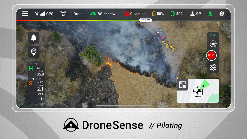
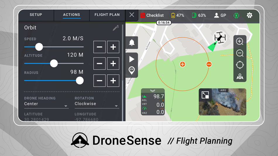
Fly a wide range of professional drones with DroneSense! Simply download this app directly onto your iPad and plug directly into any drone remote. Incorporating the latest and greatest drone is easy; there is no new training as the pilot will always fly with our app and have the same experience, no matter what drone is chosen. Share your live video stream with incident commanders easily to enable increased situational awareness on-scene. Automated flight logging ensures all data from all flights are available at any time.
For Program Administrators -
DroneSense is your complete system of record. It is a complete asset and risk management tool that provides accountability and transparency across your organization. Organize your people, hardware, and flight history in a powerful but intuitive interface. Whether it is automatically logging flight hours, filing NOTAMs, or managing personnel, DroneSense is your one-stop solution. Our software lets you quickly leverage all your resources so you can spend more time focused on the mission at hand.
For Incident Commanders -
DroneSense gives incident commanders and remote stakeholders the power to strategize and tactically collaborate. Our Operations Hub enables you to share real-time, low-latency, high definition views of a scene and plan dynamically. Anyone with a connected device can see a live pilot session, and multiple drone pilots can work together seamlessly.
Please note that usage of the DroneSense Platform requires user registration and authorization from accredited public safety agencies.
屏幕截图
新版变化
- 版本: 2023.10.1
- 已更新:
- New and Improved:
- Added support for streaming device telemetry in MSAT with the app running in the background / screen locked
- Added option to change call sign without leaving the mission
- Updated speaker implementation for Mavic 2 enterprise series
- Now including QEP status in DJI flight logs to update hardware in Airbase
- Added option to format storage for ANAFI drones
- Updated 'IR Cut' setting to 'Night Scene'
- Updated format for some alerts on Matrice 300
Bug Fixes:
- Fixed issue with Matrice 300 not zooming when using custom button setting
- Fixed issue with trackpad tap on Matrice 300 for DroneSense Remote
- Fixed issue with Lock Gimbals setting on Matrice 300
价格
- 今天: 免费
- 最小值: 免费
- 最大值: 免费
可选
开发人员
- DroneSense INC
- 平台: iOS 应用 (2)
- 列表: 0 + 0
- 积分: 0 + 35 ¡
- 排名: 0
- 评价: 0
- 折扣: 0
- 视频: 0
- RSS: 订阅
积分
未找到 ☹️
排名
未找到 ☹️
列表
未找到 ☹️
评价
抢先评价一下吧!
其他信息
您可能还喜欢
-
- Drone Maps Japan
- iOS 应用: 导航 来自: Keishi Ishimura
- 免费
- 列表: 0 + 0 排名: 0 评价: 0
- 积分: 0 + 11 版本: 1.66 Prohibited Airspace for Flight Green areas: Airspace around airports Red areas: Densely Inhabited Districts (DID) Yellow areas (black frame line): Important facilities Sunrise, sunset ...
-
- Drone Assist - Flight Planning
- iOS 应用: 导航 来自: Altitude Angel Ltd
- 免费
- 列表: 0 + 0 排名: 0 评价: 0
- 积分: 0 + 5 版本: 2.3.119973 Plan and submit your drone flights, check the weather, fly safely, and be in control with Drone Assist, the industry s most trusted drone flight situational awareness source. Do your ...
-
- SkyNav
- iOS 应用: 导航 来自: Elilan Ganesathas
- 免费
- 列表: 0 + 0 排名: 0 评价: 0
- 积分: 0 + 2 版本: 1.6.1 Embark on a journey through the skies with SkyNav, the leading drone airspace and mapping app for pilots of all skill levels across Canada, the USA, and the UK. Designed for drone ...
-
- Axon Air powered by DroneSense
- iOS 应用: 导航 来自: DroneSense INC
- 免费
- 列表: 0 + 0 排名: 0 评价: 0
- 积分: 0 + 6 版本: 2023.10.1 Axon Air powered by DroneSense is the complete drone solution for public safety. Real-time aerial situational awareness and coordination: Wireless live streaming to Axon Respond ...
-
- Dronetag
- iOS 应用: 导航 来自: Dronetag
- 免费
- 列表: 0 + 0 排名: 0 评价: 0
- 积分: 0 + 2 版本: 2.95.0 Dronetag brings an all-in-one solution for safe drone flights that allows you to comply with the new European regulations, manage your fleet and stay informed about your current ...
-
- Sail Fiji Cruising Guide
- iOS 应用: 导航 来自: Sail South Pacific Ltd.
- $49.99
- 列表: 0 + 0 排名: 0 评价: 0
- 积分: 0 + 22 版本: 5.3.1 This interactive Cruising Guide is designed to help cruisers whether under sail or power safely navigate Fiji Waters. The Sail Fiji Cruising Guide DOES NOT rely on an internet ...
-
- Aerial Armor
- iOS 应用: 导航 来自: Aerial Armor
- 免费
- 列表: 0 + 0 排名: 0 评价: 0
- 积分: 0 + 8 版本: 1.0.34 (4.0) Aerial Armors mobile app provides easy access to drone activity. Please NOTE: This app is only available to security professionals WHO HAVE SUBSCRIBED to our drone detection data ...
-
- Datatool
- iOS 应用: 导航 来自: Scorpion Automotive Ltd
- 免费
- 列表: 0 + 0 排名: 0 评价: 0
- 积分: 0 + 2 版本: 2.3.19 Datatool is a Thatcham insurance industry approved GPS/GLONASS/GSM based tracking and theft notification service designed specifically for scooters and motorcycles but now with Journey
-
- Seeker / GPS Arrow Navigator
- iOS 应用: 导航 来自: Keisuke Fukuda
- 免费
- 列表: 0 + 0 排名: 0 评价: 0
- 积分: 0 + 4 版本: 1.17.0 KEY FEATURES Just follow the direction of the arrow, even if you have no sense of direction Simple UI that can be used with one hand Apple Watch support Selectable theme colors Dark ...
-
- HapticNav
- iOS 应用: 导航 来自: WearWorks
- * 免费
- 列表: 0 + 0 排名: 0 评价: 0
- 积分: 0 + 12 版本: 1.4.8 HapticNav® is a haptic navigation app, paired with an optional HapticNav® wristband, that gently guides you to your destination using vibration, without the need for any visual or ...
-
- Compass ⊘
- iOS 应用: 导航 来自: Christophe Pereira
- * 免费
- 列表: 0 + 0 排名: 0 评价: 0
- 积分: 0 + 5,487 版本: 13.3 The most beautiful free compass for iPhone, iPhone X and iPad. Simple beautiful rustic style compass for your iPhone and iPad. Know your location, altitude and orientation instantly ...
-
- iCMTGIS PRO
- iOS 应用: 导航 来自: CORVALLIS MICROTECHNOLOGY, INC.
- $299.99
- 列表: 0 + 0 排名: 0 评价: 0
- 积分: 0 + 7 版本: 1.2.5 iCMTGIS PRO is a professional GPS/GIS mapping, data collection and stakeout app for use on the iPad and iPhone devices. It can be used to effectively collect data and increase ...
-
- ANRA Mission Planner
- iOS 应用: 导航 来自: ANRA Technologies
- 免费
- 列表: 0 + 0 排名: 0 评价: 0
- 积分: 0 + 4 版本: 1.3.2 ANRA Mission Planner app provides a convenient way to plan missions for drones and see the airspace information. There are two mission profiles (Line String & Polygrid) which help ...
-
- D-Space
- iOS 应用: 导航 来自: Marco Tricarico
- * 免费
- 列表: 0 + 0 排名: 0 评价: 0
- 积分: 3 + 0 版本: 3.1.7 It is the first entirely Italian app that helps the SAPR pilot or the simple drone enthusiast to understand where he can fly and what kind of permissions are needed to do so. The app ...