| 開發人員: | DroneSense INC (2) | ||
| 價錢: | 免費 | ||
| 排名: | 0 | ||
| 評測: | 0 寫評論 | ||
| 清單: | 0 + 0 | ||
| 點數: | 0 + 32 (4.6) ¡ | ||
| App Store | |||
描述
")
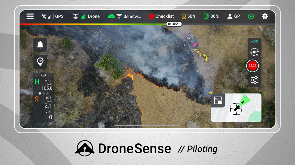
Fly a wide range of professional drones with DroneSense! Simply download this app directly onto your iPad and plug directly into any drone remote. Incorporating the latest and greatest drone is easy; there is no new training as the pilot will always fly with our app and have the same experience, no matter what drone is chosen. Share your live video stream with incident commanders easily to enable increased situational awareness on-scene. Automated flight logging ensures all data from all flights are available at any time.
For Program Administrators -
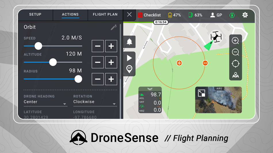
DroneSense is your complete system of record. It is a complete asset and risk management tool that provides accountability and transparency across your organization. Organize your people, hardware, and flight history in a powerful but intuitive interface. Whether it is automatically logging flight hours, filing NOTAMs, or managing personnel, DroneSense is your one-stop solution. Our software lets you quickly leverage all your resources so you can spend more time focused on the mission at hand.
For Incident Commanders -
DroneSense gives incident commanders and remote stakeholders the power to strategize and tactically collaborate. Our Operations Hub enables you to share real-time, low-latency, high definition views of a scene and plan dynamically. Anyone with a connected device can see a live pilot session, and multiple drone pilots can work together seamlessly.
Please note that usage of the DroneSense Platform requires user registration and authorization from accredited public safety agencies.
螢幕擷取畫面
新功能
- 版本: 2024.5.1
- 發佈日期:
- New and Improved:
- Updated login UI
- Added option to enable Face ID or Touch ID for login
- Added Cycle Gimbal Preset custom button option
- Moved Format Storage Location option back to main menu for camera settings
Bug Fixes:
- Fixed issue where MSAT running in background would sometimes disconnect from OpsHub after 15m
- Fixed issue on the M300 where zooming in side-by-side mode would only zoom the thermal view
- Fixed issue where reset gimbal option would move dual gimbals even if not locked together
- Fixed issue with inconsistent Autel Evo II streaming to OpsHub after a battery swap
- Fixed issue where weather would fail to populate on mission selector
- Fixed issue where imagery layers would sometimes fail to load
價錢
- 今天: 免費
- 最小值: 免費
- 最大值: 免費
追蹤票價
開發人員
- DroneSense INC
- 平台: iOS 應用程式 (2)
- 清單: 0 + 0
- 點數: 0 + 33 ¡
- 排名: 0
- 評測: 0
- 折扣: 0
- 影片: 0
- RSS: 訂閱
點數
0 ☹️
排名
0 ☹️
清單
0 ☹️
評測
成為第一個評論 🌟
其他資訊
- 🌟 分享
- App Store
你可能還喜歡
-
- Drone Assist - Flight Planning
- iOS 應用程式: 地圖與導航 由: Altitude Angel Ltd
- 免費
- 清單: 0 + 0 排名: 0 評測: 0
- 點數: 0 + 20 (4.6) 版本: 2.4.182332 Plan and submit your drone flights, check the weather, fly safely, and be in control with Drone Assist, the industry s most trusted drone flight situational awareness source. Do your ... ⥯
-
- Drone Maps Japan
- iOS 應用程式: 地圖與導航 由: Keishi Ishimura
- * 免費
- 清單: 0 + 0 排名: 0 評測: 0
- 點數: 0 + 11 (3.7) 版本: 3.1.2 Prohibited Airspace for Flight Green areas: Airspace around airports Red areas: Densely Inhabited Districts (DID) Yellow areas (black frame line): Important facilities Emergency ... ⥯
-
- Estonian Drone Map
- iOS 應用程式: 地圖與導航 由: Lennuliiklusteeninduse AS
- 免費
- 清單: 0 + 0 排名: 0 評測: 0
- 點數: 0 + 0 版本: 1.5 Estonian Drone Map is the official UTM solution from Estonian Air Navigation Services. The application allows you to see the rules for flying in Estonia, plan your flights and ... ⥯
-
- Compass ⊘
- iOS 應用程式: 地圖與導航 由: Christophe Pereira
- 免費
- 清單: 0 + 0 排名: 0 評測: 0
- 點數: 1 + 6,096 (4.6) 版本: 14.4 Compass : The Most Elegant and Accurate Compass App for iPhone and iPad Transform your iPhone and iPad into a beautifully designed, highly accurate compass. With its rustic aesthetic ... ⥯
-
- D-Space
- iOS 應用程式: 地圖與導航 由: D-Space SRLS
- * 免費
- 清單: 0 + 0 排名: 0 評測: 0
- 點數: 3 + 0 版本: 3.3.3 D-Space The first Italian app for safe and compliant drone flights D-Space is the most complete drone flight planning app in Italy. Whether you re a professional pilot or a drone ... ⥯
-
- Swiss DroneMap
- iOS 應用程式: 地圖與導航 由: Benjamin Koch
- $9.99
- 清單: 0 + 0 排名: 0 評測: 0
- 點數: 0 + 1 (5.0) 版本: 1.0.9 Shows the relevant informations to fly a drone in Switzerland. The relevant aviation data get updated each day. DABS data gets updated every hour. We show you where you can fly and ... ⥯
-
- ok2fly
- iOS 應用程式: 地圖與導航 由: BJA Consulting Pty Ltd
- * 免費
- 清單: 0 + 0 排名: 0 評測: 0
- 點數: 0 + 0 版本: 1.5.1 Whether you are a recreational drone pilot or a fully-fledged professional drone pilot, ok2fly™ is the drone safety tool you need for you next drone mission. ok2fly boasts the ... ⥯
-
- SkyNav
- iOS 應用程式: 地圖與導航 由: Elilan Ganesathas
- * 免費
- 清單: 0 + 0 排名: 0 評測: 0
- 點數: 0 + 3 (5.0) 版本: 3.0.4 SkyNav is the sophisticated drone mapping and airspace awareness solution for pilots across Canada, the USA, and the UK. Designed for both professional operators and dedicated ... ⥯
-
- SkyGuard for Drones
- iOS 應用程式: 地圖與導航 由: Aerial Tech AG
- 免費
- 清單: 0 + 0 排名: 0 評測: 0
- 點數: 0 + 1 (5.0) 版本: 1.5 Skyguard for Drones makes your drone flights worry free. Whether you re a novice drone pilot or an experienced one, SkyGuard ensures your journey in the skies remains trouble-free. It ... ⥯
-
- DMS: DCAA Monitoring System
- iOS 應用程式: 地圖與導航 由: DCAA IT SUPPORT
- 免費
- 清單: 0 + 0 排名: 0 評測: 0
- 點數: 0 + 0 版本: 1.0.50 Our app revolutionizes drone flight management by offering a seamless way to request, track, and monitor drone operations in real-time. Designed for both casual users and professional ... ⥯
-
- ANRA NOON
- iOS 應用程式: 地圖與導航 由: ANRA Technologies
- 免費
- 清單: 0 + 0 排名: 0 評測: 0
- 點數: 0 + 1 (1.0) 版本: 1.0.7 ANRA NOON facilitates planning your operations through an easy-to-use interface. This planning is informed through a rich, integrated data set that includes aeronautical data sources, ... ⥯
-
- AirPlate
- iOS 應用程式: 地圖與導航 由: AirPlate
- 免費
- 清單: 0 + 0 排名: 0 評測: 0
- 點數: 0 + 0 版本: 2.0.1 AirPlate offers cutting-edge drone detection and Remote ID solutions designed to enhance safety and ensure compliance with European legislation. With our Remote ID Pro, easily retrofit ⥯
-
- Dronetag
- iOS 應用程式: 地圖與導航 由: Dronetag
- 免費
- 清單: 0 + 0 排名: 0 評測: 0
- 點數: 0 + 8 (2.9) 版本: 2.180.5 Dronetag brings an all-in-one solution for safe drone flights that allows you to comply with the new European regulations, manage your fleet and stay informed about your current ... ⥯
-
- Sail Fiji Cruising Guide
- iOS 應用程式: 地圖與導航 由: Sail South Pacific Ltd.
- $49.99
- 清單: 0 + 0 排名: 0 評測: 0
- 點數: 0 + 26 (4.2) 版本: 5.4.0 This interactive Cruising Guide is designed to help cruisers whether under sail or power safely navigate Fiji Waters. The Sail Fiji Cruising Guide DOES NOT rely on an internet ... ⥯