描述
")
information across over 3,200 counties (99% of the US). In addition, the App also provides
access to residential addresses and contact information in over 500 counties, primarily across
the Midwest. Local, regional, and national businesses are shown on the map and are invited to
be represented in the App alongside other organizations.
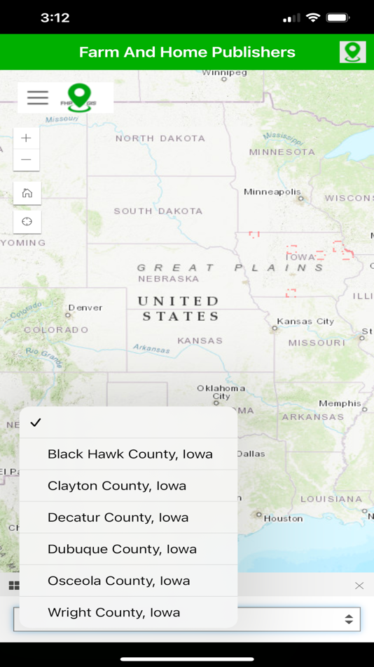
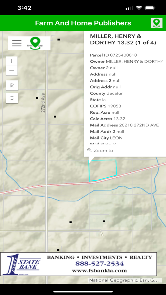
Several unique data sets are included in the FHP GIS App. These include:
- Nationwide parcel ownership data, including addresses, property values, owner
information, and much more.
- Regional geocoded residential data, including contact information
- Businesses and organizations, as geocoded locations and scrolling banners
- Public Land Survey System (PLSS) Townships and Sections, nationwide
- Nationwide US Census Subdivisions (Civil Townships and Census County Division (CCDs))
- Nationwide counties and states
- Worldwide satellite imagery
- Worldwide street and administrative areas
- Nationwide National Agriculture Imagery Program (NAIP) imagery in real-color
- Nationwide National Agriculture Imagery Program (NAIP) imagery in infrared-color
- Real-time traffic feeds
- Real-time weather feeds
- Real-time natural disaster feeds
- More.
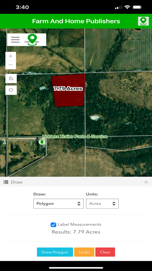
Additionally, several unique tools and functions are included in the FHP GIS App. These include:
- A custom search tool, by parcel owner, resident name, business owner, as well as
searching by location, place name, or address
- A secure login experience manages the user’s map experience.
- Filtering the user experience, specifically on Parcels and Resident data, to select
counties based on accessible counties to that particular user
- Map interactions are customized to retrieve information from select layers through
interactive click events
- Layers are interactively turned on and off in the map view
- A map key/legend is dynamically generated based on the visible map layers
- Measuring tools to help determine area, length, and XY location, in several different
unit-of-measurement options
- Drawing tools to allow temporary markups and notes
- Additional layers accessible from external web feeds
- Bookmarks to establish stored locations and zoom extents for the user’s map view
- Screenshot and print-to-file for storing information for later
For the customer already familiar with Farm and Home Publisher’s Plat Books, the FHP GIS App
extends the printed books and provides a digital, interactive view of the same map contents. In
addition, it adds more layers and will be ever-expanding to incorporate the needs and wishes of
the FHP community.
螢幕擷取畫面
價錢
- 今天: 免費
- 最小值: 免費
- 最大值: 免費
追蹤票價
點數
0 ☹️
排名
0 ☹️
清單
0 ☹️
評測
成為第一個評論 🌟
其他資訊
聯絡人
- 🌟 分享
- App Store
你可能還喜歡
-
- GIS KPO
- iOS 應用程式: 地圖與導航 由: АОЗТ «Карачаганак Петролиум Оперейтинг Б.В.»
- 免費
- 清單: 0 + 0 排名: 0 評測: 0
- 點數: 0 + 0 版本: 1.6 KPO GIS mobile application is a part of the general corporate Geographical Information System of Karachaganak Petroleum Operating B.V. Kazakhstan branch. The mobile application is ... ⥯
-
- Catalis GIS
- iOS 應用程式: 地圖與導航 由: Catalis, LLC
- 免費
- 清單: 0 + 0 排名: 0 評測: 0
- 點數: 0 + 0 版本: 2.2 Access your Catalis WebMap information on the move using Catalis GIS. View and collect data in real-time using your device s GPS location, increasing efficiency of field data ... ⥯
-
- DDA GIS Portal
- iOS 應用程式: 地圖與導航 由: Dubai Development Authority
- 免費
- 清單: 0 + 0 排名: 0 評測: 0
- 點數: 0 + 0 版本: 1.1.7 This app serves as a mobile iteration of the esteemed DDA GIS Portal web application, aimed at providing users with a fluid and unified experience across their handheld devices. The ... ⥯
-
- Farming GPS GIS II
- iOS 應用程式: 地圖與導航 由: CORVALLIS MICROTECHNOLOGY, INC.
- $94.99
- 清單: 0 + 0 排名: 0 評測: 0
- 點數: 0 + 0 版本: 1.0.4 Farming GPS GIS II provides GPS data collection and mapping functionality for use on the iPad. It will let you use a GPS receiver to map a farm tract, a timber tract or any other land ... ⥯
-
- REMaps - GIS Renewable Energy
- iOS 應用程式: 地圖與導航 由: Daniel Gaston
- 免費
- 清單: 0 + 0 排名: 0 評測: 0
- 點數: 0 + 5 (5.0) 版本: 1.0.13 RE Maps allows its users to find, visualize and fetch information about renewable energy maps for locations across the world. The RE Maps app has everything you need to around ... ⥯
-
- topoXpress
- iOS 應用程式: 地圖與導航 由: TopoLynx GIS & Mapping Ltd
- 免費
- 清單: 0 + 0 排名: 0 評測: 0
- 點數: 0 + 3 (4.0) 版本: 1.3.1 topoXpress provides the following features: Multiplatform design: the same software with the same rich functionality for both GIS data collectors and Surveyors on iOS & macOS. Handling ⥯
-
- Northway GeoSketch
- iOS 應用程式: 地圖與導航 由: Bluefield GIS, Inc.
- 免費
- 清單: 0 + 0 排名: 0 評測: 0
- 點數: 0 + 0 版本: 1.1 Game changing! Unlock the power of your Northway Ranch Services GIS account with this intuitive mapping tool. Northway GeoSketch gives you color pens and highlighters to make sketches ... ⥯
-
- Al Murshid for iPhone
- iOS 應用程式: 地圖與導航 由: The Centre for GIS - MMUP
- 免費
- 清單: 0 + 0 排名: 0 評測: 0
- 點數: 0 + 3 (3.7) 版本: 7.6 A bilingual iOS app developed by The Centre for GIS - Ministry of Municipality & Urban Planning - State of Qatar. The application displays Aerial/Satellite imagery and vector maps for ... ⥯
-
- LandGlide: Find Property Lines
- iOS 應用程式: 地圖與導航 由: Real Estate Portal USA, LLC
- 免費
- 清單: 0 + 0 排名: 0 評測: 0
- 點數: 0 + 54,426 (4.8) 版本: 5.4.1 LandGlide® is a premier property data app, giving you the most advanced and comprehensive parcel data, property line maps, and satellite maps. Whether you re a real estate agent, ... ⥯
-
- Rail Response
- iOS 應用程式: 地圖與導航 由: Global Information Systems, LLC
- 免費
- 清單: 0 + 0 排名: 0 評測: 0
- 點數: 0 + 1 (5.0) 版本: 1.0.30 GIS-based application that will provide the LIRC and the emergency providers along the LIRC route with a common interface that is compatible across all mobile devices. ⥯
-
- Coordinates – GPS Converter
- iOS 應用程式: 地圖與導航 由: Mapnitude Company Limited
- 免費
- 清單: 0 + 0 排名: 0 評測: 0
- 點數: 2 + 5,903 (4.7) 版本: 9.11.2 Coordinates is a powerful and user-friendly tool for anyone working with geographic locations from travelers and surveyors to engineers and GIS professionals. Instantly view, convert, ... ⥯
-
- Zeno Connect
- iOS 應用程式: 地圖與導航 由: Leica Geosystems AG
- 免費
- 清單: 0 + 0 排名: 0 評測: 0
- 點數: 0 + 4 (4.5) 版本: 4.1 Zeno Connect for iOS brings the power of Leica GNSS smart antennas to your iPhone/iPad. Simply connect and configure your antenna via Bluetooth and start using your favorite data ... ⥯
-
- MARVLIS Client 4
- iOS 應用程式: 地圖與導航 由: Bradshaw Consulting Services, Inc
- 免費
- 清單: 0 + 0 排名: 0 評測: 0
- 點數: 0 + 1 (5.0) 版本: 4.0.35 MARVLIS™ Client 4** is your in-vehicle connection to your dispatch center. Designed with the driver in mind, Client utilizes GPS and wireless communications to display realtime maps ... ⥯
-
- Map Plus
- iOS 應用程式: 地圖與導航 由: Miocool Inc.
- 免費
- 清單: 1 + 1 排名: 0 評測: 0
- 點數: 0 + 615 (4.6) 版本: 2.9.0 The most powerful and versatile tool for viewing and editing custom maps, surveying, editing or managing mass of your geography data. You can use Map Plus as a professional GIS tool ... ⥯