| 開發人員: | АОЗТ «Карачаганак Петролиум Оперейтинг Б.В.» (3) | ||
| 價錢: | 免費 | ||
| 排名: | 0 | ||
| 評測: | 0 寫評論 | ||
| 清單: | 0 + 0 | ||
| 點數: | 0 + 0 ¡ | ||
| App Store | |||
描述
")
The mobile application is designed for providing access to the corporate maps of GIS portal on mobile devices.
Main objectives of the application are provision of possibilities for collecting spatial data in the field, improvement of the safety level and arrangement the controls over the movement of employees and mobile facilities at the field.
Main functionality
• Authorization in the KPO corporate GIS portal
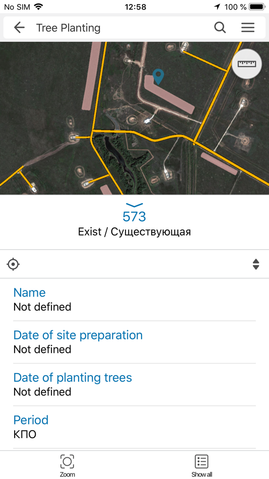
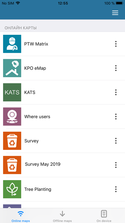
• View catalog of online and offline maps of KPO GIS-portal
• Work with online and offline maps of KPO GIS-portal
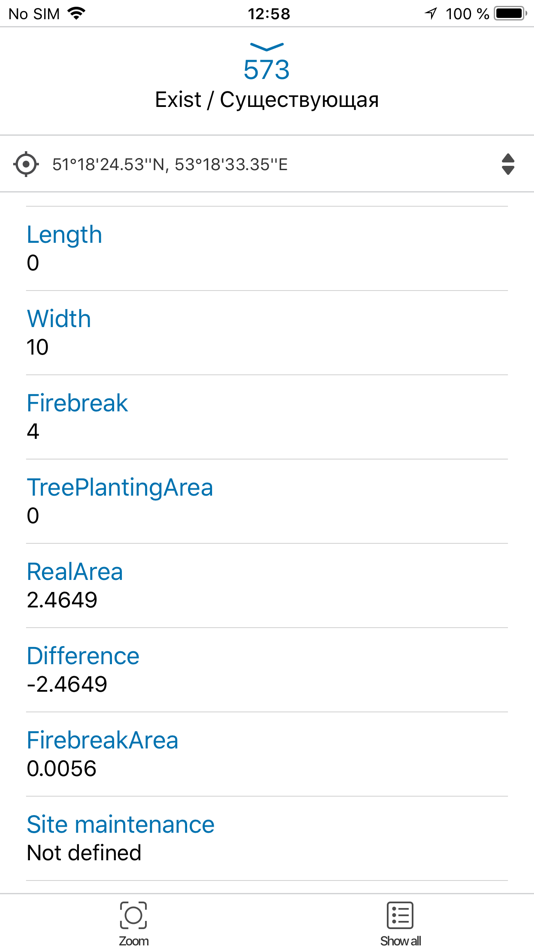
• View attributes of map objects and other related objects
• Browsing/Navigation (pan, zoom, rotate, show current location)
• Searching objects on the map
• View map layers legend
• Control the layers visibility
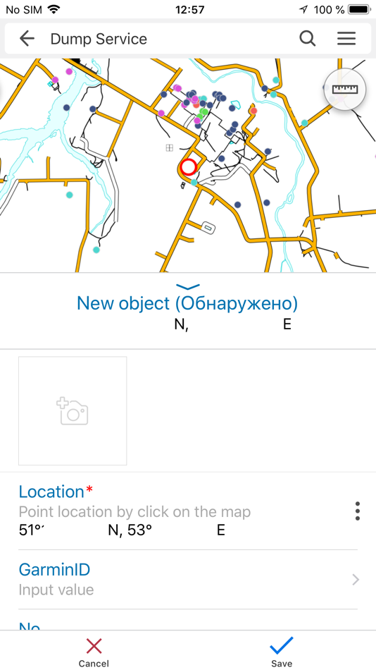
• Track recording in editable offline layers on mobile device, with automatic, postponed sending to the server, or at the user's command
• Creation of point, linear or polygonal objects by GPS or by indicating the location on the map:
• Fill the attributes of created objects with dropdown list support.
• Save objects created in editable offline layers with attached photos (video files, documents) on mobile device with further publication on the server.
• In real time, transfer the position of the mobile device to the server.
螢幕擷取畫面
價錢
- 今天: 免費
- 最小值: 免費
- 最大值: 免費
追蹤票價
開發人員
- АОЗТ «Карачаганак Петролиум Оперейтинг Б.В.»
- 平台: iOS 應用程式 (3)
- 清單: 0 + 0
- 點數: 0 + 0 ¡
- 排名: 0
- 評測: 0
- 折扣: 0
- 影片: 0
- RSS: 訂閱
點數
0 ☹️
排名
0 ☹️
清單
0 ☹️
評測
成為第一個評論 🌟
其他資訊
- 🌟 分享
- App Store
你可能還喜歡
-
- Catalis GIS
- iOS 應用程式: 地圖與導航 由: Catalis, LLC
- 免費
- 清單: 0 + 0 排名: 0 評測: 0
- 點數: 0 + 0 版本: 2.2 Access your Catalis WebMap information on the move using Catalis GIS. View and collect data in real-time using your device s GPS location, increasing efficiency of field data ... ⥯
-
- FHP GIS App
- iOS 應用程式: 地圖與導航 由: FHP
- 免費
- 清單: 0 + 0 排名: 0 評測: 0
- 點數: 0 + 6 (2.8) 版本: 2.0.2 The FHP GIS App provides a nationwide map-based view of parcel boundary and owner information across over 3,200 counties (99% of the US). In addition, the App also provides access to ... ⥯
-
- DDA GIS Portal
- iOS 應用程式: 地圖與導航 由: Dubai Development Authority
- 免費
- 清單: 0 + 0 排名: 0 評測: 0
- 點數: 0 + 0 版本: 1.1.7 This app serves as a mobile iteration of the esteemed DDA GIS Portal web application, aimed at providing users with a fluid and unified experience across their handheld devices. The ... ⥯
-
- Farming GPS GIS II
- iOS 應用程式: 地圖與導航 由: CORVALLIS MICROTECHNOLOGY, INC.
- $94.99
- 清單: 0 + 0 排名: 0 評測: 0
- 點數: 0 + 0 版本: 1.0.4 Farming GPS GIS II provides GPS data collection and mapping functionality for use on the iPad. It will let you use a GPS receiver to map a farm tract, a timber tract or any other land ... ⥯
-
- REMaps - GIS Renewable Energy
- iOS 應用程式: 地圖與導航 由: Daniel Gaston
- 免費
- 清單: 0 + 0 排名: 0 評測: 0
- 點數: 0 + 5 (5.0) 版本: 1.0.13 RE Maps allows its users to find, visualize and fetch information about renewable energy maps for locations across the world. The RE Maps app has everything you need to around ... ⥯
-
- topoXpress
- iOS 應用程式: 地圖與導航 由: TopoLynx GIS & Mapping Ltd
- 免費
- 清單: 0 + 0 排名: 0 評測: 0
- 點數: 0 + 3 (4.0) 版本: 1.3.1 topoXpress provides the following features: Multiplatform design: the same software with the same rich functionality for both GIS data collectors and Surveyors on iOS & macOS. Handling ⥯
-
- Northway GeoSketch
- iOS 應用程式: 地圖與導航 由: Bluefield GIS, Inc.
- 免費
- 清單: 0 + 0 排名: 0 評測: 0
- 點數: 0 + 0 版本: 1.1 Game changing! Unlock the power of your Northway Ranch Services GIS account with this intuitive mapping tool. Northway GeoSketch gives you color pens and highlighters to make sketches ... ⥯
-
- Al Murshid for iPhone
- iOS 應用程式: 地圖與導航 由: The Centre for GIS - MMUP
- 免費
- 清單: 0 + 0 排名: 0 評測: 0
- 點數: 0 + 3 (3.7) 版本: 7.6 A bilingual iOS app developed by The Centre for GIS - Ministry of Municipality & Urban Planning - State of Qatar. The application displays Aerial/Satellite imagery and vector maps for ... ⥯
-
- LandGlide: Find Property Lines
- iOS 應用程式: 地圖與導航 由: Real Estate Portal USA, LLC
- 免費
- 清單: 0 + 0 排名: 0 評測: 0
- 點數: 0 + 54,426 (4.8) 版本: 5.4.1 LandGlide® is a premier property data app, giving you the most advanced and comprehensive parcel data, property line maps, and satellite maps. Whether you re a real estate agent, ... ⥯
-
- Rail Response
- iOS 應用程式: 地圖與導航 由: Global Information Systems, LLC
- 免費
- 清單: 0 + 0 排名: 0 評測: 0
- 點數: 0 + 1 (5.0) 版本: 1.0.30 GIS-based application that will provide the LIRC and the emergency providers along the LIRC route with a common interface that is compatible across all mobile devices. ⥯
-
- Coordinates – GPS Converter
- iOS 應用程式: 地圖與導航 由: Mapnitude Company Limited
- 免費
- 清單: 0 + 0 排名: 0 評測: 0
- 點數: 2 + 5,903 (4.7) 版本: 9.11.2 Coordinates is a powerful and user-friendly tool for anyone working with geographic locations from travelers and surveyors to engineers and GIS professionals. Instantly view, convert, ... ⥯
-
- Zeno Connect
- iOS 應用程式: 地圖與導航 由: Leica Geosystems AG
- 免費
- 清單: 0 + 0 排名: 0 評測: 0
- 點數: 0 + 4 (4.5) 版本: 4.1 Zeno Connect for iOS brings the power of Leica GNSS smart antennas to your iPhone/iPad. Simply connect and configure your antenna via Bluetooth and start using your favorite data ... ⥯
-
- MARVLIS Client 4
- iOS 應用程式: 地圖與導航 由: Bradshaw Consulting Services, Inc
- 免費
- 清單: 0 + 0 排名: 0 評測: 0
- 點數: 0 + 1 (5.0) 版本: 4.0.35 MARVLIS™ Client 4** is your in-vehicle connection to your dispatch center. Designed with the driver in mind, Client utilizes GPS and wireless communications to display realtime maps ... ⥯
-
- Map Plus
- iOS 應用程式: 地圖與導航 由: Miocool Inc.
- 免費
- 清單: 1 + 1 排名: 0 評測: 0
- 點數: 0 + 615 (4.6) 版本: 2.9.0 The most powerful and versatile tool for viewing and editing custom maps, surveying, editing or managing mass of your geography data. You can use Map Plus as a professional GIS tool ... ⥯