기술
ACCURATE LAND MEASUREMENT
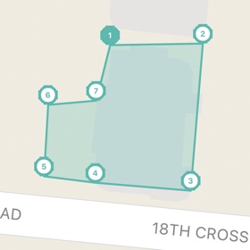
Measure any land area with precision using two proven methods. Place points manually on the satellite map for exact boundary definition, or walk the perimeter with GPS tracking for hands-free measurement. Field Calculator calculates area instantly as you map, giving you real-time results in your preferred units.
COMPREHENSIVE UNIT SUPPORT
Work in the units that matter to your profession. Field Calculator supports square meters, square feet, acres, hectares, square kilometers, square miles, and square yards. Switch between metric and imperial systems with one tap. Perfect for international projects and cross-border property work.
PROFESSIONAL FEATURES
Save unlimited measurements with Premium and organize your projects efficiently. Each saved measurement includes the complete boundary data, area calculations, and timestamp for your records. Access your measurement history anytime and reload previous projects directly onto the map.
EXPORT AND SHARE
Generate professional PDF reports with satellite imagery and detailed measurement data. Export to KML for Google Earth, GeoJSON for GIS applications, GPX for GPS devices, or CSV for spreadsheet analysis. Share measurements with clients, colleagues, or government agencies in industry-standard formats.
GPS TRACKING MODE
Walk the boundary of any property and let Field Calculator track your path automatically. The app records your GPS position continuously, creating an accurate outline of the land. Ideal for large farms, rural properties, and areas where manual point placement is impractical.
SATELLITE AND TERRAIN VIEWS
View your measurements on high-resolution satellite imagery to identify boundaries, structures, and landmarks. Switch to terrain view to understand elevation changes across the property. Hybrid mode combines satellite detail with road and label information.
BUILT FOR PROFESSIONALS
Field Calculator serves the needs of agricultural professionals measuring crop fields and pastures. Real estate agents use it to verify property boundaries and lot sizes. Construction managers calculate site areas for project planning. Land surveyors appreciate the GPS accuracy and export capabilities. Government agencies trust the measurement precision for official assessments.
CIRCULAR MEASUREMENT
Measure circular areas like irrigation pivot systems, storage tanks, grain bins, and round structures. Define the center point and radius to calculate area and circumference instantly. Essential for agricultural and industrial applications.
WORKS OFFLINE
Downloaded map areas remain available without internet connection. Continue measuring in remote locations where cellular coverage is limited. Your saved measurements sync automatically when connectivity returns.
PRIVACY FOCUSED
Field Calculator processes all measurements locally on your device. Your location data and property measurements are never uploaded to external servers without your explicit action to export or share.
Download Field Calculator today and experience professional-grade land measurement in your pocket. Join farmers, surveyors, and property professionals who trust Field Calculator for accurate area and distance calculations.
Terms of Service: https://www.apple.com/legal/internet-services/itunes/dev/stdeula/
새로운 기능
- 버전: 1.0.0
- 업데이트:
가격
-
* 인앱 구매 - 오늘: 무료
- 최소: 무료
- 최대: 무료
가격 추적
포인트
-

- 6,879 Jay Gillera
- +1

순위
0 ☹️
목록
0 ☹️
리뷰
첫 번째 리뷰를 남겨보세요 🌟
추가 정보
주소록
- 웹사이트:
 https://jalsaa.com/
- 🌟 공유하기
- App Store
당신은 또한 같은 수 있습니다
-
- GPS-Platform
- iOS 앱: 내비게이션 게시자: GPS Plateform Ltd
- 무료
- 목록: 0 + 0 순위: 0 리뷰: 0
- 포인트: 0 + 0 버전: 1.2 This is mobile client of GPS-Platform tracking application. To use the application, you need a personal account or access to hosted software. Demo Account Credentials: Username: demo ... ⥯
-
- Field Command Pro
- iOS 앱: 내비게이션 게시자: Field Command Pro
- 무료
- 목록: 0 + 0 순위: 0 리뷰: 0
- 포인트: 2 + 3 (5.0) 버전: 1.1.27 (Build 14) Field Command is the essential real-time intelligence app for everyone who relies on, works with, or simply loves snow. From professional contractors and ski resort operators to ... ⥯
-
- GPS TechTracker Pro
- iOS 앱: 내비게이션 게시자: GPS California SA de CV
- 무료
- 목록: 1 + 0 순위: 0 리뷰: 0
- 포인트: 1 + 0 버전: 2.18.11 GPS TechTracker provides you with a powerful tool with real-time capability that includes detailed professional reports, reproduction of the routes used in each trip, multiple alerts, ... ⥯
-
- GPS ASSIST: Vehicle Tracking
- iOS 앱: 내비게이션 게시자: GPS ASSIST LTD
- 무료
- 목록: 0 + 0 순위: 0 리뷰: 0
- 포인트: 0 + 0 버전: 1.1 GPS ASSIST - Smarter Tracking. Requires a GPS ASSIST device to use this app. Take full control of your vehicle s security with GPS ASSIST, the companion app designed to work ... ⥯
-
- My GPS Area Calculator
- iOS 앱: 내비게이션 게시자: MYSTIC MOBILE APPS LLC
- * 무료
- 목록: 0 + 0 순위: 0 리뷰: 0
- 포인트: 1 + 10 (4.5) 버전: 2.64 With our app, measuring the area of spaces is even easier. Dual Mode Precision: Enjoy easy GPS-based or manual map-pointing measurements for accurate area calculations. Unmatched ... ⥯
-
- GPS Fleet Manager
- iOS 앱: 내비게이션 게시자: Optimus GPS Tracking Corp
- 무료
- 목록: 0 + 0 순위: 0 리뷰: 0
- 포인트: 0 + 3 (3.3) 버전: 3.10.22 GPS Fleet Manager App is the mobile version of our tracking platform. - Manage your vehicles and other GPS devices. - Track your vehicle in real time. - Receive alerts by: * Push ... ⥯
-
- GPS Logistic
- iOS 앱: 내비게이션 게시자: ADVANCED GPS TECHNOLOGY OOD
- 무료
- 목록: 0 + 0 순위: 0 리뷰: 0
- 포인트: 0 + 0 버전: 5.3.0 The application is designed to show information from company site "prosledi.com", to carry out it's main activity - GPS monitoring of subscribers, for which a contract has been ... ⥯
-
- GO.GPS.AZ
- iOS 앱: 내비게이션 게시자: GPS Solutions MMC
- 무료
- 목록: 0 + 0 순위: 0 리뷰: 0
- 포인트: 0 + 0 버전: 2.17.8 The mobile application allow subscribers of GPS.AZ service, which equipment is connected to GPS monitoring system, track their objects in real-time mode from a mobile phone or a tablet ⥯
-
- Field maps - Distance Measure
- iOS 앱: 내비게이션 게시자: Gorasiya Vishal Nanjibhai
- * 무료
- 목록: 0 + 0 순위: 0 리뷰: 0
- 포인트: 0 + 0 버전: 1.2 Field maps - GPS inspection Accurate Land Survey & GPS Measurement Field maps - GPS inspection is a powerful and easy-to-use tool for measuring land area, distance, and perimeter using ⥯
-
- GPS Land Calculator
- iOS 앱: 내비게이션 게시자: Liam Sammy
- 무료
- 목록: 0 + 0 순위: 0 리뷰: 0
- 포인트: 0 + 72 (4.5) 버전: 1.6 Easy to use, useful app for an area, distance and perimeter management. This tool is helping for million people to measure their fields, mark their needed points and sharing their ... ⥯
-
- GPS Speedometer: Speed Tracker
- iOS 앱: 내비게이션 게시자: Mikhail Nikitsin
- 무료
- 목록: 0 + 0 순위: 0 리뷰: 0
- 포인트: 0 + 5,289 (4.5) 버전: 1.8.0 GPS Speedometer is the most elegant and unique combination of speedometer and trip computer in one application. Just start the application and it will automatically record your speed, ... ⥯
- 새로운
- GPS Metrics
- iOS 앱: 내비게이션 게시자: Berend Hartman
- $3.99
- 목록: 0 + 0 순위: 0 리뷰: 0
- 포인트: 0 + 0 버전: 1.0 GPS Metrics is your compact and accurate companion on the move. See live speed, altitude, course and more, visualize your track on the map with color by speed, export GPX/KML, and send ⥯
-
- GPS Navigation & Live Map
- iOS 앱: 내비게이션 게시자: Amit Lakhani
- 무료
- 목록: 0 + 0 순위: 0 리뷰: 0
- 포인트: 0 + 295 (4.3) 버전: 2.8 GPS Navigation with voice navigation, live map, traffic, offline Gps & direction. GPS Navigation with voice navigation, live map, traffic, offline Gps & direction. Map GPS navigation ... ⥯
-
- GPS Navigation - Map Direction
- iOS 앱: 내비게이션 게시자: Ravi Munjani
- 무료
- 목록: 0 + 0 순위: 0 리뷰: 0
- 포인트: 0 + 68 (4.3) 버전: 1.9 GPS Navigation with voice navigation, live map, traffic, offline Gps & direction. GPS Navigation with voice navigation, live map, traffic, offline Gps & direction. Map GPS navigation ... ⥯