| 开发人员: | Lonnie Ganz (4) | ||
| 价格: | $9.99 | ||
| 排名: | 0 | ||
| 评价: | 0 我要评价 | ||
| 列表: | 0 + 0 | ||
| 积分: | 0 + 16 (4.7) ¡ | ||
| App Store | |||
说明
")
If you are considering a career in aviation FlyBy E6B has functions that you can use in every aircraft you will fly.
FlyBy E6B was one of the very first applications of its kind published for the Palm Pilot. Used by thousands of pilots the world over, it has evolved from the suggestions and feedback we have received.
Please visit our web site for more detail and screen shots.
FlyBy E6B Features (70+):
Airspeed Calculations:
- True Airspeed using Calibrated Airspeed
- True Airspeed using Mach#
- Calibrated Airspeed using TAS
- IAS Using MACH#
- Equivalent Airspeed using CAS
- Mach# Using TAS
- Mach Crossover Altitude
- Planned MACH#
- Planned TAS
- Vref CAS
Wind Calculation:
- Find Wind Direction and Speed
- Find Wind Component (headwind and crosswind)
Heading and Ground Speed:
- Find Heading, Ground Speed, ETE and Fuel Burned
Time-Speed-Distance:
- Find Estimated Time Enroute
- Find Ground Speed
- Find Distance
- Find Fuel Time
- Find Fuel Flow
- Find Fuel Burned
- Find Estimated Time of Arrival
- Journey Log Time
- Time Adder
- Fixed GroundSpeed (Find a True Airspeed given a track, wind and required groundspeed)
- Crew Rest
Altitude Calculations:
- Density Altitude
- Pressure Altitude
- True Altitude
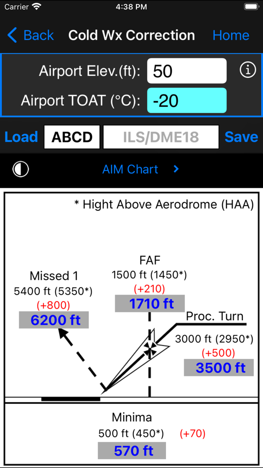
- Cold Temperature Altitude Correction
- China RVSM Airspace
- Device Altitude (If device has pressure sensor)
Vertical Navigation Calculations:
- Distance and Time using Altitude Change, Ground Speed, Vertical Speed
- Rate of Descent using Altitude Change, Ground Speed, Distance
- Rate of Descent using Altitude Change, Ground Speed, Descent Angle
- Feet/Nm using Vertical Speed, Ground Speed
- Feet/Nm (%) using Gradient %, Ground Speed
- Rate of Climb using Required Climb Gradient and Ground Speed
- SCDA (Constant Descent Angle)
- VDP (Visual Descent Point)
- VPA Deviation (Vertical Path Angle Deviation)
Navigation Calculations:
- Critical Point
- Equal Time Point
- Point of No Return
- Time to Minimum Descent Altitude
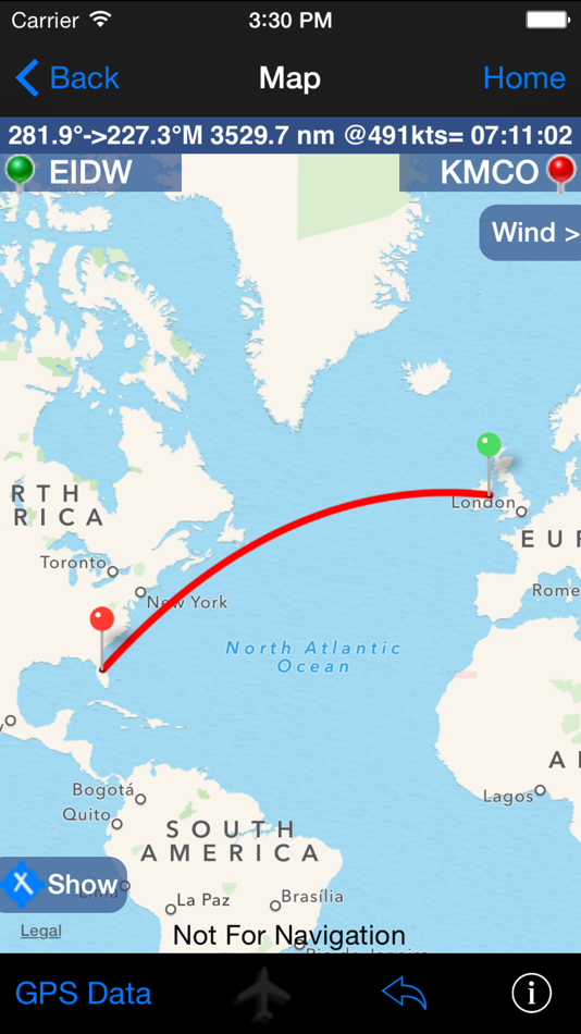
- Track and Distance between two points with map plotting of the great circle track. Map plotting includes movable pin locations with instant trip information: Distance, Track and time enroute.
- Map GPS mode. Displays device Speed, True Course, Altitude, Distance Remaining, Track to Destination, cross track error, estimated time remaining and estimated time of arrival.
- Map closest airport feature will display airports close to your current GPS location or a dropped pin location.
- Fix. Calculate a map point based on a Fix, Radial and Distance.
- Rate One Turn
- Radius of Turn
- Turning Stall Speed
- DME Arc distance and time
- VOR Nav
Conversions:
- Distance:
Nautical Miles/ Knots
Statute Miles/ Mph
Kilometers/ Kph
Feet
Meters
Meters/Second
Feet/Second
Feet/Minute
- Volume:
US Gallons
Imperial Gallons
Liters
- Temperature:
Celsius
Fahrenheit
Kelvin
- Weight:
Pounds
Kilograms
- Altimeter:
Inches Hg
Millibars/Hectopascals
mmHg
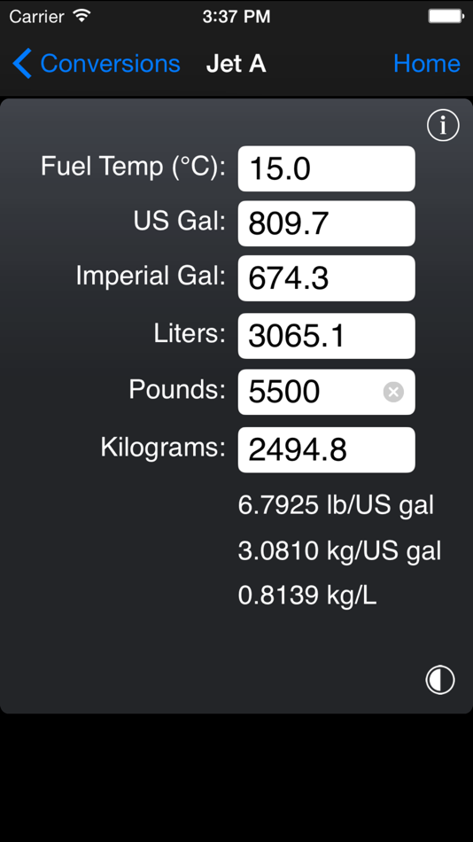
- Fuel, Temperature Corrected, JetA, JetB, AvGas:
US Gallons
Imperial Gallons
Liters
Pounds
Kilograms
- QFE/QNH airfield altitude conversion
- DMS/DM.m/DM.m and D.d coordinate conversion
- VNAV
Gradient%
Feet per NM
Angle
Weather:
- Relative Humidity, Heat Index, Cumulus cloud base, Wind Chill
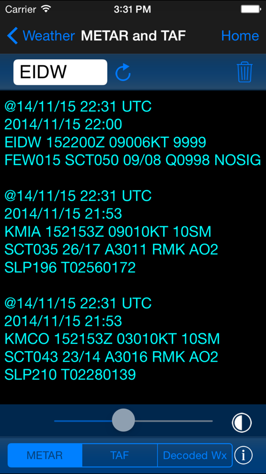
- NOAA METAR and TAF access
- ISA Temperature Deviation
Other Functions:
- Linear Interpolation
- Minimum Floor Load Limit (Cargo)
- Maximum Cargo Weight
- Runway Slope
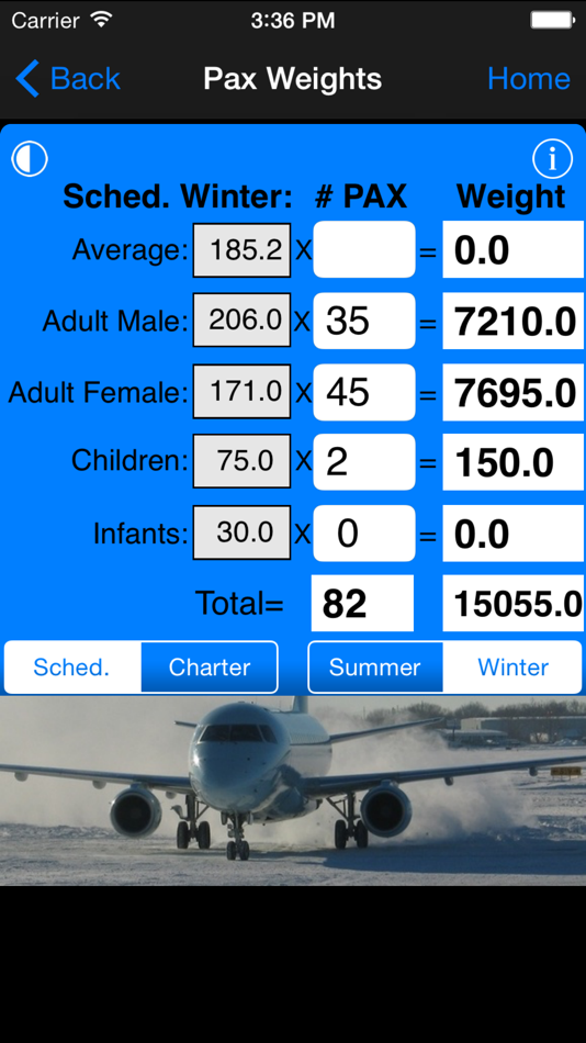
- PAX Weight
- C.G. Change
- Weight to Shift
- Distance to Shift
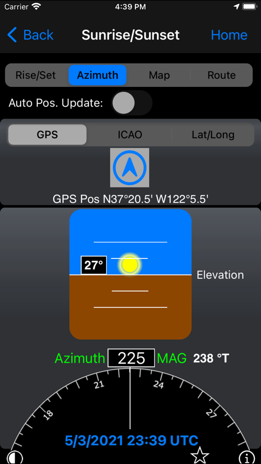
- Sunrise/Sunset: Civil Day/Night, Azimuth, Apex, Elevation, for any location and time/date. Includes a unique sunset ETA function that calculates your current flights sunset time.
屏幕截图

价格
- 今天: $9.99
- 最小值: $6.99
- 最大值: $9.99
可选
开发人员
- Lonnie Ganz
- 平台: iOS 应用 (4)
- 列表: 0 + 0
- 积分: 0 + 23 ¡
- 排名: 0
- 评价: 0
- 折扣: 0
- 视频: 0
- RSS: 订阅
积分
0 ☹️
排名
0 ☹️
列表
0 ☹️
评价
抢先评价一下吧 🌟
其他信息
通讯录
您可能还喜欢
-
- E6b Pilot
- iOS 应用: 导航 来自: Navtech Software
- $3.99
- 列表: 0 + 0 排名: 0 评价: 0
- 积分: 0 + 1 (5.0) 版本: 2.2 E6b Pilot - the e6b calculator for iPhone and iPad with 5 primary and 24 supporting utilities to assist the private or professional pilot in flight planning. Also included is a timer ... ⥯
-
- E6B+ E6B Flight Calculator
- iOS 应用: 导航 来自: Tung Huynh
- 免费
- 列表: 0 + 0 排名: 0 评价: 0
- 积分: 0 + 18 (4.8) 版本: 1.0.1 # E6B+ E6B Flight Calculator 2025! The Essential Tool for Every Pilot Conquer the skies with E6B+ E6B Flight Calculator, the ultimate flight computer app that makes complex aviation ... ⥯
-
- E6B Aviation Weather
- iOS 应用: 导航 来自: Joel Schirmer
- $2.99
- 列表: 0 + 0 排名: 0 评价: 0
- 积分: 1 + 2 (5.0) 版本: 1.6 E6B Aviation Weather packs the power of a full-size flight computer, a precision countdown timer, and live weather widgets into a single, pilot-friendly app. Whether you re a student ... ⥯
-
- Fly Baby: Navigate in Style
- iOS 应用: 导航 来自: Kyle Ramirez
- $2.99
- 列表: 0 + 0 排名: 0 评价: 0
- 积分: 0 + 0 版本: 1.2 Fly Baby is a set of premium cockpit navigation instruments and waypoint info that stays on your wrist wherever you go, giving you the ability to navigate to any destination across the ⥯
-
- Fly Virga
- iOS 应用: 导航 来自: Aviation Apps, LLC
- 免费
- 列表: 0 + 0 排名: 0 评价: 0
- 积分: 0 + 17 (3.9) 版本: 1.57 Pilots can now unleash the power of real time PIREPs for flight planning, management and safety. Virga is aviation s only app that allows pilots to submit PIREPs without the need for ... ⥯
-
- Fly Local
- iOS 应用: 导航 来自: Studio BabDreams
- 免费
- 列表: 0 + 0 排名: 0 评价: 0
- 积分: 0 + 0 版本: 1.1.1 Compute a safe altitude for your glider plane on a local flight. The app uses the GPS to display your relative position to an airfield and compute a safe glide altitude according to ... ⥯
-
- PFMA E6B
- iOS 应用: 导航 来自: TATA Mobile
- $6.99
- 列表: 0 + 0 排名: 0 评价: 0
- 积分: 0 + 11 (4.4) 版本: 1.5.0 Pocket Flight Management Assistant (PFMA) is a flight computer designed for the professional pilot, with a familiar look resembling the computers onboard most modern automated ... ⥯
-
- FlightReady E6B
- iOS 应用: 导航 来自: Aeroapps Technology
- $7.99
- 列表: 0 + 0 排名: 0 评价: 0
- 积分: 1 + 993 (4.7) 版本: 1.16.0 Over 100 aviation functions, conversions, and utilities, including functions that you won't find in any other E6B. Each function uses the correct scientific formula to ensure accuracy. ⥯
-
- TroutRoutes: Fly Fishing App
- iOS 应用: 导航 来自: onXmaps, Inc.
- 免费
- 列表: 0 + 0 排名: 0 评价: 0
- 积分: 3 + 3,694 (4.5) 版本: 5.3.2 TroutRoutes by onX is the #1 GPS mapping tool for trout streams and fly fishing. As the first mapping tool that includes interactive GPS fishing maps for every trout stream in the ... ⥯
-
- Quick E6B
- iOS 应用: 导航 来自: Paul LeBlanc
- $1.99
- 列表: 0 + 0 排名: 0 评价: 0
- 积分: 0 + 0 版本: 1.25.1 This is a great E6B program with all the standard features along with a host of extra features. Runs on an iPhone, iPad or iPod. - Standard Features: Wind triangle calculations(GS, TC, ⥯
-
- Trout Stream GPS - Fly Fishing
- iOS 应用: 导航 来自: Distal Industries, LLC
- * 免费
- 列表: 0 + 0 排名: 0 评价: 0
- 积分: 0 + 3 (2.7) 版本: 6.0 WHAT IS TROUT STREAM GPS? Trout Stream GPS shows you where to park and fish on America's trout streams. The app is free to download, and maps are available for in-app purchase. FLY ... ⥯
-
- Spartan Tracker UK
- iOS 应用: 导航 来自: Fly delivery ltd
- 免费
- 列表: 0 + 0 排名: 0 评价: 0
- 积分: 0 + 0 版本: 3.0.7 Fleets management compatible portal and report systems you are ready to track a There s almost no learning curve for Spartan Tracker users. Our customers tell us that the easy-to-use ... ⥯
-
- Moovit: Bus & Transit Tracker
- iOS 应用: 导航 来自: Moovit App Global LTD
- 免费
- 列表: 1 + 0 排名: 0 评价: 0
- 积分: 1 + 52,480 (4.6) 版本: 5.177.2 Transform the way you navigate your city with Moovit, the all-in-one app for urban transit. Whether you re taking the bus, subway, train, or even hopping on a dockless scooter, Moovit ... ⥯
-
- Holding Pattern Computer
- iOS 应用: 导航 来自: Aviation Mobile Apps, LLC.
- $11.99
- 列表: 0 + 0 排名: 0 评价: 0
- 积分: 0 + 176 (4.9) 版本: 3.0.2 Fly with Confidence: Holding Pattern App Elevate your flying skills with Version 3.0 of the Holding Pattern App, meticulously crafted by aerospace experts. Ideal for both new and ... ⥯