| Developer: | Half Mile Labs LLC (2) | ||
| Price: | Free | ||
| Rankings: | 0 | ||
| Reviews: | 0 Write a Review | ||
| Lists: | 2 + 2 | ||
| Points: | 1 + 20,371 (4.8) ¡ | ||
| App Store | |||
Description
")
Footpath is the ultimate companion for planning and navigating custom routes.
Join millions of adventurers and plan out your perfect route.
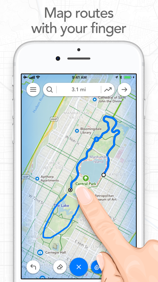
SNAP TO MAP
Quickly measure distances by tracing a map with your finger or Apple Pencil. Footpath will snap to roads and trails on the map.
MEASURE DISTANCE AND ELEVATION
Know exactly how far and how high you'll travel with elevation profiles. Plan routes that match your goals.
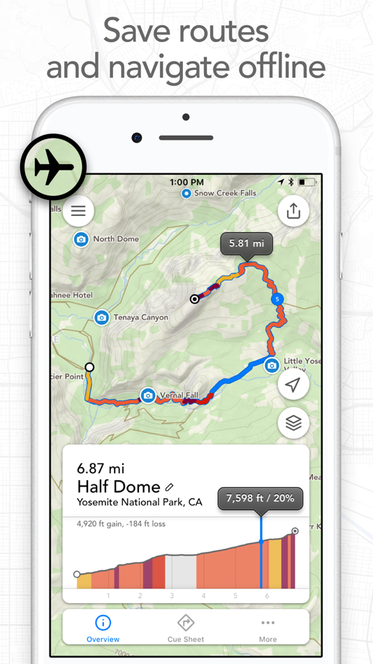
SAVE ROUTES FOR LATER
Plan out your week or trip. Keep up to 5 routes on hand for reference, or save unlimited routes with Footpath Elite.
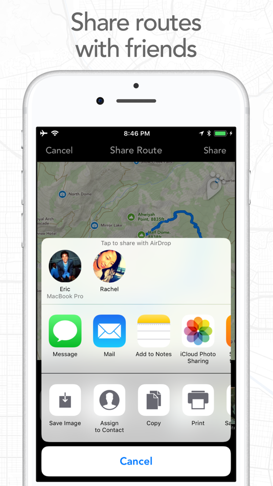
SHARE ROUTES
Send your routes to friends or workout partners to open on their device.
Footpath is designed to work for pretty much any activity or adventure, in any country:
• Running
• Cycling and mountain biking
• Hiking and mountaineering
• Walking
• Motorcycling and driving
• Backcountry skiing
• Kayaking and standup paddleboarding
• Sailing
• And many more!
FOOTPATH ELITE
Ready to go the extra mile? Upgrading to Footpath Elite unlocks the following powerful features:
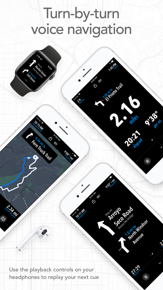
TURN-BY-TURN NAVIGATION
- Footpath will tell you when to turn with turn-by-turn audio cues on your iPhone and Apple Watch
- Save your route and cues in advance for voice guidance that works completely offline
- Double tap your AirPods or use the playback controls button on your headphones to replay your next cue
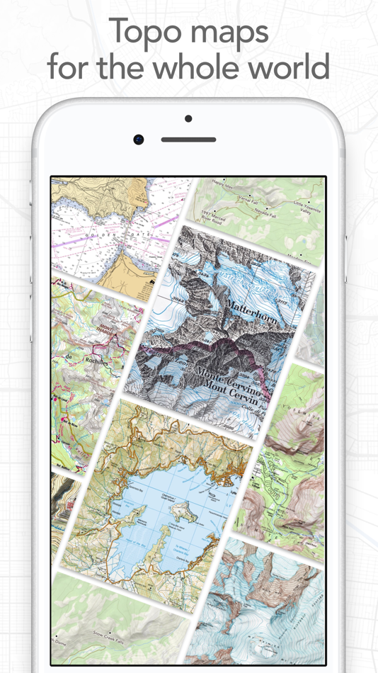
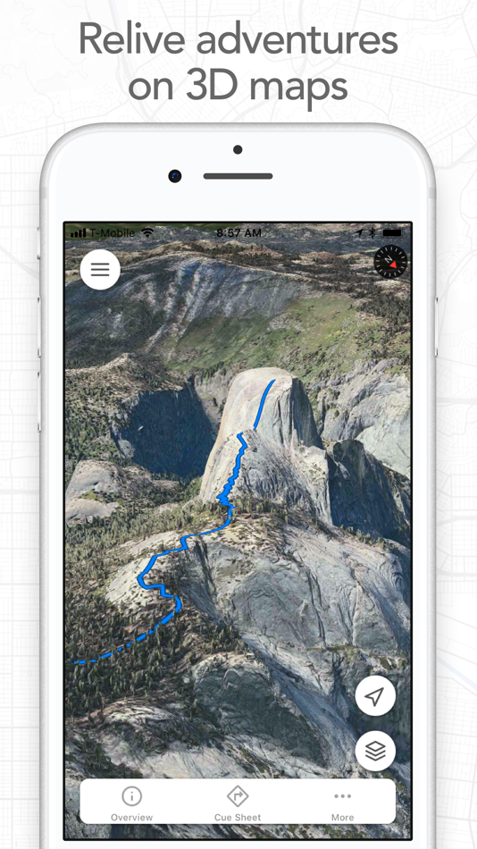
PREMIUM OFFLINE MAPS
- 3D and topographic maps including Footpath Outdoors (Worldwide), USGS Topo Maps (U.S. and Canada), OpenCycleMap (Worldwide), and many more
- Cycling lanes, avalanche slope shading, and elevation contour lines
- Download maps for use offline
- Save places as favorites to customize your maps
ORGANIZE
- Create and edit unlimited saved routes
- Duplicate, merge, and split routes
- Organize and sort routes into custom lists
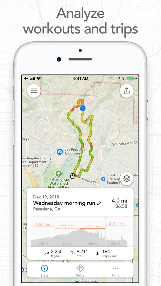
ANALYZE
- Record GPS tracks of your activities
- Use HealthKit display and log extra health and fitness metrics such as heart rate during a GPS activity
- View a calendar log and weekly summary of your activities
- Analyze splits, speed, elevation, and heart rate
- View a heatmap of your speed during your activity
EXPORT
- GPX import and export
- TCX and FIT course export for turn-by-turn navigation on Garmin and Wahoo GPS devices
- Export cue sheets to a spreadsheet app for customization and printing
- Export your routes and workouts to Apple Health
You can purchase a Footpath Elite monthly or yearly subscription through your iTunes account. Your subscription will automatically renew unless cancelled at least 24 hours before the end of the current period. Auto-renew can be turned off anytime by going to the Manage Subscriptions page in settings after purchase, and your features will remain active until the end of the subscription period. Your account will be charged for renewal within 24-hours prior to the end of the current period at the same cost as your original purchase.
TIPS FOR MAPPING ROUTES
• For longer routes, try zooming in and mapping your route in multiple segments.
• Tap and hold the map to quickly route between waypoints and POIs.
• Did Footpath snap to the wrong roads? Trace over the incorrect segment to edit, or use the eraser tool.
• Turn off snap to roads (magnet icon) and zoom in to manually trace the map. (Try switching to a satellite layer).
• Displaying maps and continuously running GPS in the background can dramatically decrease battery life. Navigate without maps or with the screen off for all day battery life.
CONTACT US
We've got a lot planned for Footpath. If you have any suggestions or feedback, or if you run into any issues, please contact us at support@footpathapp.com
Terms of Service: https://footpathapp.com/terms
Privacy Policy: https://footpathapp.com/privacy
Screenshots
What's new
- Version: 4.10.7
- Updated:
- - Bug fixes
Leave us an App Store review if you're enjoying Footpath, or feel free to contact us at support@footpathapp.com with any problems or suggestions.
Price History
- Today: Free
- Minimum: Free
- Maximum: Free
Track prices
Developer
- Half Mile Labs LLC
- Platforms: Android Apps (1) iOS Apps (1)
- Lists: 2 + 2
- Points: 2 + 28,360 ¡
- Rankings: 0
- Reviews: 0
- Discounts: 0
- Videos: 0
- RSS: Subscribe
Points
-

- 385 shopman
- +1

Rankings
0 ☹️
Lists


Reviews
Be the first to review 🌟
Additional Information
- Version: 4.10.7
- ID: com.ericrwolfe.Footpath
- Category:
iOS Apps›Navigation - OS:
Apple Watch,iPad,iPhone,iOS 16.0 and up - Size:
110 Mb - Supported Languages:
Chinese,Danish,Dutch,English,French,German,Italian,Japanese,Portuguese,Spanish,Swedish - Content Rating:
4+ - App Store Rating:
4.8(20,371) - Updated:
- Release Date:
Contacts
- Website:
 https://footpathapp.com
«Footpath Route Planner» is a Navigation app for iOS, developed by «Half Mile Labs LLC». It was first released on and last updated on . This app is currently free. This app has not yet received any ratings or reviews on AppAgg. It has been added to 2 public lists and 2 private lists created by users. AppAgg has tracked 1 confirmed points plus 20,371 indirect points for this app. On App Store, the current store rating is 4.8 based on 20,371 votes. Available languages: Chinese, Danish, Dutch, English, French, German, Italian, Japanese, Portuguese, Spanish, Swedish. AppAgg continuously tracks the price history, ratings, and user feedback for «Footpath Route Planner». Subscribe to this app or follow its RSS feed to get notified about future discounts or updates.
You may also like
-
- Route4Me Route Planner
- iOS Apps: Navigation By: Route4Me Inc
- Free
- Lists: 0 + 0 Rankings: 0 Reviews: 0
- Points: 2 + 11,481 (4.6) Version: 14.9.3 Get home early and in a good mood! Route4Me s mobile route planning app creates simple, stress-free routes for you in seconds. In-app, voice-guided navigation right in the route ... ⥯
-
- Circuit Route Planner
- iOS Apps: Navigation By: Circuit Routing
- * Free
- Lists: 0 + 0 Rankings: 0 Reviews: 0
- Points: 1 + 8,779 (4.7) Version: 3.19.23 Easy-to-use multi-stop route planner and delivery app downloaded by over 10 million drivers - Sign up for a FREE trial today! Deliver more packages and finish your route faster. Save ... ⥯
-
- RoadWarrior Route Planner
- iOS Apps: Navigation By: MapQuest Holdings LLC
- Free
- Lists: 0 + 1 Rankings: 0 Reviews: 0
- Points: 0 + 6,820 (4.7) Version: 2025.06.231 Create reliable multi-destination routes with your trusty copilot, RoadWarrior Route Planner. Designed for drivers, couriers and traveling professionals, RoadWarrior gives you a ... ⥯
-
- PlaceMaker Route Planner
- iOS Apps: Navigation By: Resting Cranes LLC
- Free
- Lists: 0 + 0 Rankings: 0 Reviews: 0
- Points: 2 + 3,946 (4.7) Version: 1.3.187 PlaceMaker - Top Rated Route Planning App Top rated route planner for routes with up to 500 stops per route. View stops on a map or launch your favorite navigation application. In-app ... ⥯
-
- Washington DC Metro Route Map
- iOS Apps: Navigation By: Mapway Limited
- Free
- Lists: 0 + 0 Rankings: 0 Reviews: 0
- Points: 0 + 12,193 (4.6) Version: 4.1.0 Washington DC Metro is the navigation app that makes travelling by WMATA transit in Washington DC simple From the Lincoln Memorial to the Smithsonian, cheering on the Washington ... ⥯
-
- Google Maps
- iOS Apps: Navigation By: Google
- Free
- Lists: 14 + 9 Rankings: 5 (3) Reviews: 5 (1)
- Points: 5 + 6,907,226 (4.7) Version: 25.42.1 Explore and navigate the world with confidence using Google Maps. Find the best routes with live traffic data and real-time GPS navigation for driving, walking, cycling, and public ... ⥯
-
- Waze Navigation & Live Traffic
- iOS Apps: Navigation By: Waze Inc.
- Free
- Lists: 9 + 4 Rankings: 5 (1) Reviews: 0
- Points: 1 + 3,076,205 (4.8) Version: 5.12.0.2 Know what's ahead on the road with the help from other drivers. Waze is a live map that harnesses the local knowledge of tens of millions of drivers around the world. Drivers safely ... ⥯
-
- Transit • Subway & Bus Times
- iOS Apps: Navigation By: Transit App, Inc.
- Free
- Lists: 3 + 0 Rankings: 0 Reviews: 0
- Points: 0 + 819,233 (4.6) Version: 6.0.6 Transit is your real-time urban travel companion. Open the app to instantly see accurate next departure times, track buses and trains near you on the map, and see upcoming transit ... ⥯
-
- onX Hunt: GPS Hunting Maps
- iOS Apps: Navigation By: onXmaps, Inc.
- Free
- Lists: 0 + 0 Rankings: 0 Reviews: 0
- Points: 1 + 250,246 (4.9) Version: 25.39.0 Navigate your next hunt and view species distribution, topo maps, hunting units, and more. Whether you re a private or public land hunter, know where you stand with land ownership ... ⥯
-
- Gaia GPS: Mobile Trail Maps
- iOS Apps: Navigation By: TrailBehind
- Free
- Lists: 0 + 1 Rankings: 0 Reviews: 0
- Points: 2 + 31,552 (4.8) Version: 2025.10 Welcome the warm weather with the ultimate collection of hiking trails and camping sites around you Gaia GPS. Find amazing adventures with topographic maps while spending less time ... ⥯
-
- PlugShare: Charging Stations
- iOS Apps: Navigation By: Recargo, Inc.
- Free
- Lists: 0 + 0 Rankings: 0 Reviews: 0
- Points: 0 + 130,292 (4.7) Version: 7.29.0 Download the most accurate EV and Tesla charging station map. PlugShare is the world s largest EV driver community. Drivers contribute station reviews and photos to help the EV ... ⥯
-
- Trucker Path: Truck GPS & Map
- iOS Apps: Navigation By: Trucker Path Inc.
- Free
- Lists: 1 + 0 Rankings: 0 Reviews: 0
- Points: 0 + 123,790 (4.8) Version: 6.7.9 North America s most popular app for Truckers. BUILT FOR TRUCKERS, BY TRUCKERS! Get all trucker tools in one FREE APP! Best Trucking APP featured by truckers! Trucker Path is a mapping ⥯
-
- Bikemap: Bicycle Tracker & GPS
- iOS Apps: Navigation By: Bikemap GmbH
- Free
- Lists: 0 + 0 Rankings: 0 Reviews: 0
- Points: 2 + 9,222 (4.7) Version: 31.1.0 Plan, navigate and track your rides quickly and easily. Our active cycling community gives you access to millions of routes and cycle paths worldwide. BIKE TRACKER & BIKE COMPUTER Turn ⥯
-
- Supercharger map for Tesla
- iOS Apps: Navigation By: yohan teixeira
- Free
- Lists: 0 + 0 Rankings: 0 Reviews: 0
- Points: 0 + 11,955 (4.7) Version: 4.8 Supercharger for Tesla is an essential tool for any Tesla owner. With this app, you can easily find a supercharger station near you, so you never have to worry about running out of ... ⥯