| ผู้พัฒนา: | Bist LLC (21) | ||
| ราคา: | ฟรี | ||
| การจัดอันดับ: | 0 | ||
| ความเห็น: | 0 เขียนความเห็น | ||
| รายการ: | 0 + 1 | ||
| แต้มแล: | 1 + 13,700 (4.5) ¡ | ||
| App Store | |||
คำอธิบาย
")
Europe Rivers (Danube,Drava,Rhein etc). Coverage includes NOAA marine vector
charts,freshwater lake maps,USACE inland river maps (HD/1ft/3ft bathymetry
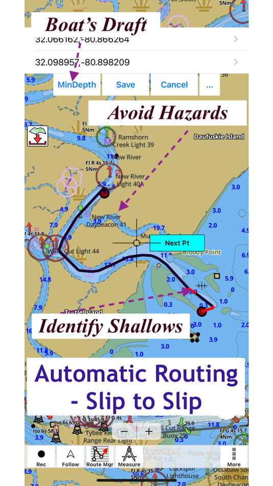
included where available),charts derived from UKHO & CHS data. First marine GPS app to have route assistance with Voice Prompts for marine navigation. You can create new boating routes or import existing GPX/KML routes. It supports Nautical Charts course up orientation. Includes Tide & Currents prediction.
►FEATURES
√ Beautiful & detailed Hardware/GPU accelerated vector charts (text stays upright on rotation)
√ Long press to query the details of Marine object (Buoy,Lights,Obstruction etc).
√ Customizable depth(Ft/Fathom/Meter) & distance units(km/mi/NM)
√ Customizable Shallow Depth.
√ Record tracks,Autofollow with real-time track overlay & predicted path vector.
√ Voice Prompts for marine navigation (requires GPS )
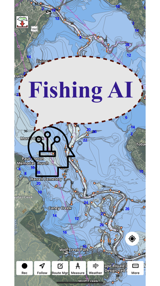
√ 1ft / 3ft depth contour maps for anglers for selected lake maps.
√ Supports GPX/KML for boating route editing/import.
√ Tide & Currents prediction.
√ Seamless chart quilting of marine charts
√ Enter or import Waypoints.
► MAPS
It includes unlimited updates for 1 year.
√USA: The maps include coverage of all NOAA marine vector charts (ENC),USACE inland river maps,freshwater lake maps for more than 7K lakes. The charts include HD/1ft/3ft bathymetry where available.Incl. NOAA raster where ENC not available.
√Canada:Incl. CHS data(incl. major Lakes).
√UK/Ireland: Derived from UKHO charts.
√Australia
√Germany: derived from BSH data
√Europe Inland Rivers:Donau/Dunaja,Rhine,Garonne,Moselle,Drava,Sava,etc
√Norway
√Finland
√Sweden
√Croatia
√Ukraine(Black Sea)
√Caribbean
√New Zealand
√Spain
√Brazil
√Argentina
√Cyprus
√Falklands
√Seychelles& Mauritius
√Denmark
√Malta,Cyprus & S. Mediterranean
√S. China&Malaysia
√South Africa
►ROUTE MANAGEMENT / TRIP PLANNING
√ Create New Route/Edit Existing Routes
√ Move Points
√ Add points to an existing route leg
√ Delete / Rename points
√ Import GPX,KML & KMZ files
√ Plot/Edit Routes
√ Enter Waypoints
√ Share/Export Routes,Tracks&Markers
√ Reverse Routes
►SLIP TO SLIP AUTO ROUTING
►GPS FEATURES
√ Auto Follow
* Real Time Track Overlay
* Predicted Path Vector
* Course Up(Text stays upright)
* Speed & Heading
√ Route Assistance With Voice Prompts
* Prompts when approaching a boating route marker
* Continous distance & ETA updates
* Alerts when sailing/boating off route
* Alerts when boating in wrong direction
√ Record Tracks
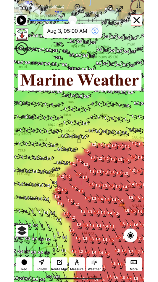
►TIDE & CURRENTS
* For US,Canada,UK,Germany & New Zealand
* High/Low Tides
* Tidal Current Prediction
* Active Current Stations
►Instrumentation
√ Marine AIS & (NMEA AIS and GPS over TCP/UDP)
√ Wind direction & Speed,Marine Sonar depth,Water temperature
√ Auto Pilot
► SHARING
* Share tracks/routes/markers on Facebook & Twitter
* Export tracks/routes/markers as GPX files.
SUGARLOAF KEY-KEY WEST
PORT RICHEY TAMPA BAY - CLEARWATER HBR
EAST BAY-WEST BAY FLORIDA
INTRACOASTAL WATERWAY MATECUMBE-GRASSY KEY
CHESAPEAKE BAY CAPE CHARLES-NORFOLK HARBOR
ANCLOTE KEYS-CRYSTAL RIVER
ST JOSEPH SOUND
MIAMI HARBOR
Minnesota lakes - Kabetogama,Minnetonka,Waconia,Leech,Mille Lacs
Lake Keowee,Jocassee,Hartwell,Greenwood,Lake Murray
Mark Twain,Ozarks,Table Rock
Lake St.Clair
Lake Kentucky
KEY WEST-THE MISSISSIPPI RIVER
SAN PEDRO CHANNEL
LAKE MICHIGAN STONY LAKE-POINT BETSIE
APALACHICOLA BAY-CAPE SAN BLAS
EAST CAPE-MORMON KEY
CAPE HENLOPEN-INDIAN RIVER
CHESAPEAKE BAY CAPE HENRY-THIMBLE SHOAL
DULUTH-SUPERIOR
MONHEGAN ISLAND-CAPE ELIZABETH
ONTARIO - CLAYTON-FALSE DUCKS
Winnipesaukee
MIAMI-MARATHON,FLORIDA
CAPE MAY-FENWICK ISLAND
MISSISSIPPI RIVER-GALVESTON
CAPE CANAVERAL-KEY
DELAWARE RIVER WILMINGTON-PHILADELPHIA
FLORIDA KEYS SOMBRERO KEY-SAND KEY
SAN PABLO BAY
RAINY LAKE BIG ISLAND MINN-OAKPOINT
INTRACOASTAL WATERWAY-BISCAYNE BAY
EVERGLADES NTL PARK
HURON
TAHOE
CHESAPEAKE DELAWARE CANAL
BACKGROUND GPS CAN DECREASE BATTERY LIFE
ภาพหน้าจอ


มีอะไรใหม่
- เวอร์ชัน: 163.0.0
- อัปเดต:
- - Lake Map Updates - MN, WI, MI, IN
- Wind/Wave - Weather Forecast changes
- Compiled with latest version of Xcode
ราคา
- วันนี้: ฟรี
- ต่ำสุด: ฟรี
- มากที่สุด: ฟรี
ติดตามราคา
ผู้พัฒนา
แต้มแล
-

- 12,853 Lance Eliakim Sotto
- +1

การจัดอันดับ
0 ☹️
รายการ
0 ☹️
ความเห็น
แสดงรีวิวเป็นคนแรกเลย 🌟
ข้อมูลเพิ่มเติม
รายชื่อติดต่อ
- เว็บไซท์:
 http://www.gpsnauticalcharts.com
- 🌟 แชร์
- App Store
คุณอาจชอบ
-
- Wavve Boating: Marine Boat GPS
- iOS แอป: การนำทาง โดย: Wavve Boating INC
- * ฟรี
- รายการ: 0 + 1 การจัดอันดับ: 0 ความเห็น: 0
- แต้มแล: 1 + 4,464 (4.7) เวอร์ชัน: 5.5.6 Ever have a stressful day navigating on the water? Wanted to know more about the conditions you are about to head into? Are you looking for exciting places to explore, the best place ... ⥯
-
- GPS Speedometer: Speed Tracker
- iOS แอป: การนำทาง โดย: Mikhail Nikitsin
- ฟรี
- รายการ: 0 + 0 การจัดอันดับ: 0 ความเห็น: 0
- แต้มแล: 0 + 5,266 (4.5) เวอร์ชัน: 1.8.0 GPS Speedometer is the most elegant and unique combination of speedometer and trip computer in one application. Just start the application and it will automatically record your speed, ... ⥯
-
- GPS & Maps: Location Tracker
- iOS แอป: การนำทาง โดย: Kraus und Karnath GbR 2Kit Consulting
- ฟรี
- รายการ: 0 + 0 การจัดอันดับ: 0 ความเห็น: 0
- แต้มแล: 2 + 2,196 (4.4) เวอร์ชัน: 4.3 GPS & Maps is a simple, yet powerful GPS app for supporting navigation and outdoor activities like geocaching, sailing, skating, trekking, biking or traveling by airplane. It measures ... ⥯
-
- GPS Speedometer, Speed Tracker
- iOS แอป: การนำทาง โดย: Nikhil Kumar
- ฟรี
- รายการ: 0 + 0 การจัดอันดับ: 0 ความเห็น: 0
- แต้มแล: 0 + 23,589 (4.8) เวอร์ชัน: 6.0.0 Track your speed with GPS accuracy using the ultimate GPS Speedometer & Odometer app. Whether you re driving a car, riding a bike, or hauling with a truck, this speed tracker gives you ⥯
-
- GPS Speedometer MPH Tracker
- iOS แอป: การนำทาง โดย: BITHAUS.TECH, UNIPESSOAL LDA
- ฟรี
- รายการ: 0 + 0 การจัดอันดับ: 0 ความเห็น: 0
- แต้มแล: 1 + 11,115 (4.7) เวอร์ชัน: 7.1.3 Transform every journey into valuable data with GPS Speedometer - the most comprehensive speed tracking app for driving, cycling, boating, and beyond. Experience professional-grade ... ⥯
-
- GPS Camera 55. Field Survey
- iOS แอป: การนำทาง โดย: Kalimex-Consulting s.r.o. @Blocoware & Stanislav Dvoychenko
- * ฟรี
- รายการ: 1 + 1 การจัดอันดับ: 0 ความเห็น: 0
- แต้มแล: 1 + 2,518 (4.7) เวอร์ชัน: 4.9 Capture photos with precise location, date, address, and custom notes stamped right on the image. Add hand-drawn annotations for quick markups in the field. Easily search and filter ... ⥯
-
- GPS Navigation & Path Finder
- iOS แอป: การนำทาง โดย: Muhammad Asad Khan
- ฟรี
- รายการ: 0 + 0 การจัดอันดับ: 0 ความเห็น: 0
- แต้มแล: 0 + 3,492 (4.6) เวอร์ชัน: 8.0.20 This GPS Navigation and Route finder app provide a bunch of functionalities including finding exact route, Direction, Navigation, Nearby Places and many more with Voice functionality. ... ⥯
-
- onX Hunt: GPS Hunting Maps
- iOS แอป: การนำทาง โดย: onXmaps, Inc.
- ฟรี
- รายการ: 0 + 0 การจัดอันดับ: 0 ความเห็น: 0
- แต้มแล: 1 + 257,549 (4.9) เวอร์ชัน: 25.43.0 Navigate your next hunt and view species distribution, topo maps, hunting units, and more. Whether you re a private or public land hunter, know where you stand with land ownership ... ⥯
-
- iNavX: Marine Navigation
- iOS แอป: การนำทาง โดย: NavX Studios LLC
- ฟรี
- รายการ: 0 + 0 การจัดอันดับ: 0 ความเห็น: 0
- แต้มแล: 7 + 20,702 (4.8) เวอร์ชัน: 5.8.1 Marine navigation is made easy with iNavX - the world's #1 handheld Chartplotter. Access marine charts, maps, weather, AIS and more! iNavX is the only app to give you complete ... ⥯
-
- Trucker Path: Truck GPS & Map
- iOS แอป: การนำทาง โดย: Trucker Path Inc.
- ฟรี
- รายการ: 1 + 0 การจัดอันดับ: 0 ความเห็น: 0
- แต้มแล: 0 + 124,972 (4.8) เวอร์ชัน: 6.8.2 North America s most popular app for Truckers. BUILT FOR TRUCKERS, BY TRUCKERS! Get all trucker tools in one FREE APP! Best Trucking APP featured by truckers! Trucker Path is a mapping ⥯
-
- Radarbot: Speed Cameras | GPS
- iOS แอป: การนำทาง โดย: Iteration Mobile S.L
- ฟรี
- รายการ: 0 + 0 การจัดอันดับ: 0 ความเห็น: 0
- แต้มแล: 3 + 95,461 (4.6) เวอร์ชัน: 9.31 Radarbot is the only app that offers real-time alerts and offline detection for speed cameras. Get comprehensive speed camera alerts, real-time traffic updates, and specific speed ... ⥯
-
- Navigraph Charts
- iOS แอป: การนำทาง โดย: Navigraph
- ฟรี
- รายการ: 0 + 1 การจัดอันดับ: 0 ความเห็น: 0
- แต้มแล: 0 + 2,227 (4.9) เวอร์ชัน: 8.38.3 Looking for the most comprehensive software solution for flight simulation? Navigraph Charts is your co-pilot. Navigraph Charts 8 has been developed with emphasis on delivering a ... ⥯
-
- My GPS Coordinates °
- iOS แอป: การนำทาง โดย: MYSTIC MOBILE APPS LLC
- ฟรี
- รายการ: 0 + 0 การจัดอันดับ: 0 ความเห็น: 0
- แต้มแล: 1 + 2,036 (4.6) เวอร์ชัน: 6.45 Get your current GPS coordinates even faster! Pinpoint Precision with High Accuracy GPS: Discover your exact coordinates, altitude, GPS precision, and satellite count, ensuring you're ... ⥯
-
- TruckMap - Truck GPS Routes
- iOS แอป: การนำทาง โดย: Tenstreet
- ฟรี
- รายการ: 0 + 0 การจัดอันดับ: 0 ความเห็น: 0
- แต้มแล: 0 + 70,916 (4.7) เวอร์ชัน: 4.80.9 TruckMap is the best free mobile app built for Truck Drivers. The only app with truck optimized GPS routes for commercial vehicles, turn-by-turn routing, diesel fuel, weigh stations, ... ⥯