기술
")
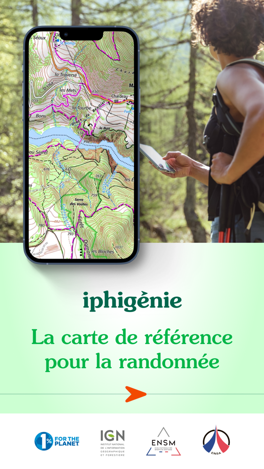
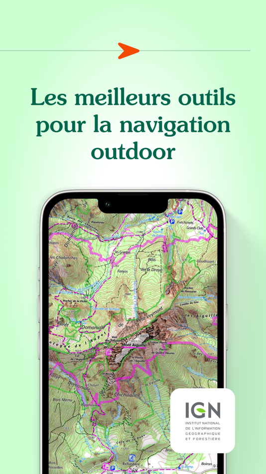
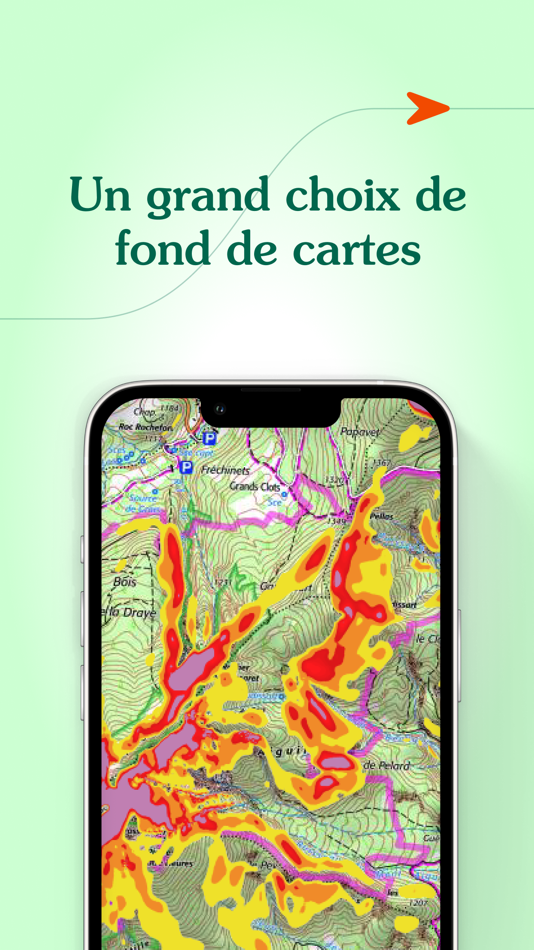
Find more than 40 detailed topographic basemaps (including IGN maps, SwissTopo, IGN Spain, OpenTopo, OpenSnow, land registry, slope inclination), even while offline.
BEFORE YOUR OUTING
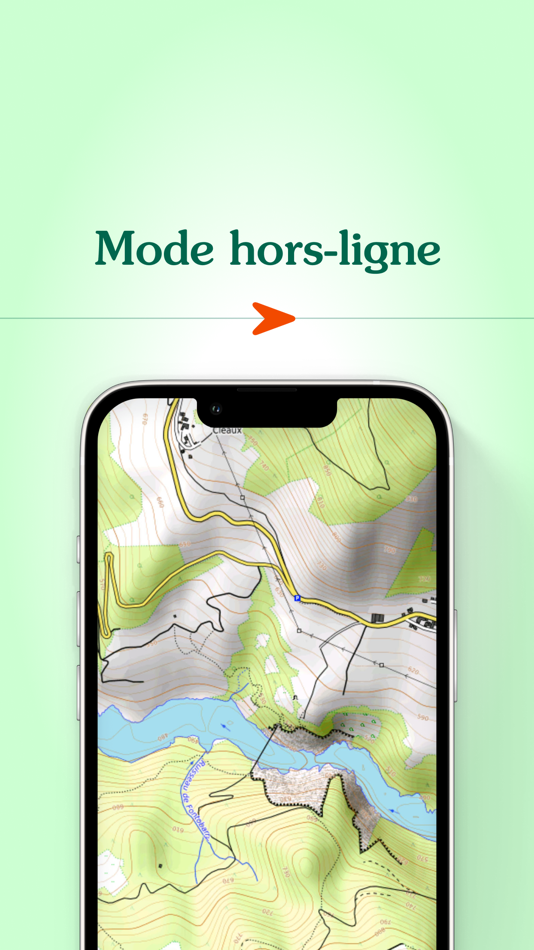
- Prepare your outing by downloading maps to access them offline
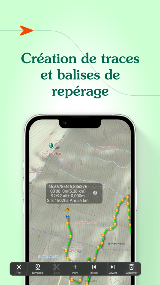
- Create, edit and import tracks
- Create and import markers (e.g. mushroom spots, departure points of routes, etc.)
- Print sections of the map if you need to
- Search for a specific location by name or by GPS details
- Access routes or landmarks from IGNRando or Data-Avalanche
- Access a 3D view and slope inclinations
DURING YOUR OUTING
- Geolocate yourself on the basemap of your choice
- Follow routes using GPS, without worrying about network availability
- Record your track
- Access real-time information such as distance traveled, elevation (±), average speed, current speed, estimated time of arrival, etc.
- Activate the beacon function to allow your loved ones to follow your progress in real-time
- Create specific voice alerts to guide you, even with your iPhone in your pocket
AFTER YOUR OUTING
- Create groups of tracks/landmarks
- Store and backup all your data in the Cloud
- Export your GPS tracks and landmarks in GPX format
- Share your outings and landmarks with all your friends
What our customers say about us:
" Thanks to Iphigénie, I discover a lot of amazing new places. I note the slopes, the summits, the lakes... It saves me precious time, especially in remote places where there are very few indications and markings! ".
In the press :
20 minutes: " Hiking, like outdoor activities, has not missed the digital shift, as Alice (25) comments. "It's hugely appreciated to be able to check accurate IGN maps, including when you no longer have a connection, as happens a lot in the high mountains".
Download the free basic app
Download the basic application for free on your smartphone. This version allows you to be geolocated on one of the 25 free base maps such as Open Topo Map, Open Cycle Map, Open Snow map. The world is within reach!
You will also have access to real-time information such as your position/course/altitude/speed.
Use the complete app with the “Iphigénie Carto” subscription
The Iphigénie Carto subscription is €24.99 per year. It gives you access to 40 base maps including those of IGN. These maps can be downloaded on your device (iPhone, iPad, iPod, Watch) so that you can access them even without a network.
You also have access to the full potential of Iphigénie by finding all the features mentioned above.
Good to know: you have 7 days to test the complete app for free.
Use the high quality Italian map with the ‘Maps of the Italian Alps’ subscription
You can buy Fraternali's 1:25,000 Italian topographic maps for €24.99 a year. This subscription gives you access to accurate, information-packed digital maps covering the western Italian Alps.
List of available maps:
- IGN France
- SwissTopo
- Fraternali
- IGN Spain
- IGN Belgium
- BKG Germany
- Kartverket Norway
- Cartographic Institute of Catalunya
- OpenTopo
- OpenCycle
- OpenSnow
- ICAO
- ESRI
- Satellite view
- Cadastre
- Slope inclination
- Restricted areas for drones
- Historical maps of France
- Geological and mining maps (France)
- National Forestry Office
We donate 1% of our turnover to 1% for the Planet to help preserve the environment.
MADE IN FRANCE
스크린샷
가격
-
* 인앱 구매 - 오늘: 무료
- 최소: 무료
- 최대: 무료
가격 추적
개발자
포인트
0 ☹️
순위
0 ☹️
목록
0 ☹️
리뷰
첫 번째 리뷰를 남겨보세요 🌟
추가 정보
주소록
- 웹사이트:
 http://www.iphigen.ie
- 🌟 공유하기
- App Store
당신은 또한 같은 수 있습니다
-
- Hiking Map Austria
- iOS 앱: 내비게이션 게시자: Daniel Tekel
- * 무료
- 목록: 0 + 0 순위: 0 리뷰: 0
- 포인트: 0 + 0 버전: 3.3 This application displays a detailed offline topographical map of Austria with hiking trails, cycling paths, points, hills, etc. You can view it in 2D and 3D mode, now also with a ... ⥯
-
- MineAR: Augmented Reality Map
- iOS 앱: 내비게이션 게시자: Map Life, LLC
- * 무료
- 목록: 0 + 0 순위: 0 리뷰: 0
- 포인트: 0 + 5 (5.0) 버전: 2.40.15 Data you can grasp. As a geoscience professional, we know you want an easier way to see your GIS data while you re in the field. MineAR allows you to do exactly that. Our app ... ⥯
-
- Map LT
- iOS 앱: 내비게이션 게시자: Taylan Atasoy
- 무료
- 목록: 0 + 0 순위: 0 리뷰: 0
- 포인트: 0 + 0 버전: 4.0 Map LT is a cutting-edge navigation and mapping application designed for users who want to easily find their way around World. With its user-friendly interface and comprehensive ... ⥯
-
- Map Map - Your Map on a Map
- iOS 앱: 내비게이션 게시자: Ben Roberts
- * 무료
- 목록: 0 + 0 순위: 0 리뷰: 0
- 포인트: 0 + 2 (5.0) 버전: 2.3 Welcome to Map Map Your Personal Cartographer! Ever wished you could see where you were on a trail map, building diagram, or any other visual reference? How about knowing where a trail ⥯
-
- Memory-Map for All
- iOS 앱: 내비게이션 게시자: Memory-Map
- 무료
- 목록: 0 + 0 순위: 0 리뷰: 0
- 포인트: 0 + 9 (4.9) 버전: 2.0.5 Download maps for Offline GPS Navigation. No mobile data connection required. Your favorite maps and charts from OS, Hema, NOAA, and many more. Immersive 3D World map view Fully ... ⥯
-
- Map MateAI- Navigate with Chat
- iOS 앱: 내비게이션 게시자: Ahmet Erkin Arıkan
- 무료
- 목록: 0 + 0 순위: 0 리뷰: 0
- 포인트: 0 + 0 버전: 1.0.3 Struggling to decide where to go? Let our app guide you! Whether you're searching for a cozy café, an exciting spot to explore, or a pharmacy on duty, we ve got you covered. Simply ... ⥯
-
- Hiking Maps
- iOS 앱: 내비게이션 게시자: HopIN Digitech Co., Ltd.
- * 무료
- 목록: 0 + 0 순위: 0 리뷰: 0
- 포인트: 0 + 0 버전: 1.3.6 Hiking Maps was developed with guidance from hardcore hiking clubs that require rich and detailed maps, offline functionality, as well as easy planning right from their phones. These ... ⥯
-
- Map Tells...!
- iOS 앱: 내비게이션 게시자: Yuriko Kimura
- 무료
- 목록: 0 + 0 순위: 0 리뷰: 0
- 포인트: 0 + 0 버전: 3.4 "Map Tells...! is an app that shares your location with your companion by providing a Google Maps link and photo. The mail receiver follows the directions (on the map or through a ... ⥯
-
- Map Points
- iOS 앱: 내비게이션 게시자: Sachin Deshpande
- $0.99
- 목록: 0 + 0 순위: 0 리뷰: 0
- 포인트: 0 + 0 버전: 1.2 Map Points is an app to store your favorite map locations. You can use it while hiking to mark pinpoint locations that you want to remember. Or you can drop a pin to mark the secret ... ⥯
-
- Map It Realtour
- iOS 앱: 내비게이션 게시자: DKP Productions LLC
- 무료
- 목록: 0 + 0 순위: 0 리뷰: 0
- 포인트: 0 + 3 (5.0) 버전: 2.0.2 Map It Realtour® / Mobile Application for Realtors With New Map It Client Version for Their Clients Map It Realtour® is a new and unique Real Estate App for Agents worldwide, that was ... ⥯
-
- Map Tools
- iOS 앱: 내비게이션 게시자: Modular Machines LLC
- $1.99
- 목록: 0 + 0 순위: 0 리뷰: 0
- 포인트: 0 + 1 (5.0) 버전: 6.1 Map Tools supports coordinate systems and map projections for 232 datums, including WGS84, NAD27, NAD83, ED50, OSGB36, EGSA87, AGD66, AGD84, GDA94, NZGD2000, NZGD1949, and many more. ... ⥯
-
- Map-in
- iOS 앱: 내비게이션 게시자: Uchechukwu Debra Ginigeme
- 무료
- 목록: 0 + 0 순위: 0 리뷰: 0
- 포인트: 0 + 4 (5.0) 버전: 10.0.0 Design interior maps of large spaces like malls, schools and hospitals. Navigate large indoor spaces with ease. Find items fast. At Map-In, we are revolutionizing the way people ... ⥯
-
- Hiking Logger
- iOS 앱: 내비게이션 게시자: CCMedia Technology Company
- $6.99
- 목록: 0 + 0 순위: 0 리뷰: 0
- 포인트: 0 + 0 버전: 3.9.7 Let Hiking Logger enrich your outdoor activities! You can record and share your adventures as well as keep every memorable moment. Also, with the offline map and GPS features, you can ... ⥯
-
- Map Snapper
- iOS 앱: 내비게이션 게시자: Mark Malone
- * 무료
- 목록: 0 + 0 순위: 0 리뷰: 0
- 포인트: 0 + 0 버전: 2.1 Plan orienteering events by placing and fine tuning control locations in the field. Create your own instant offline maps. Create geolocated maps from photos and pictures, either with ... ⥯