| 開發人員: | Navtech Software (38) | ||
| 價錢: | * 免費 | ||
| 排名: | 0 | ||
| 評測: | 0 寫評論 | ||
| 清單: | 0 + 0 | ||
| 點數: | 0 + 0 ¡ | ||
| App Store | |||
描述
")
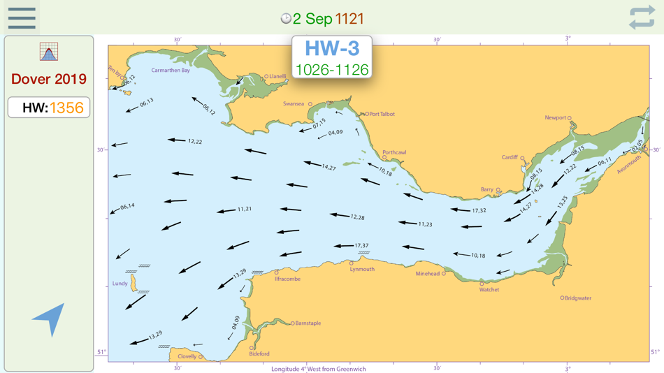
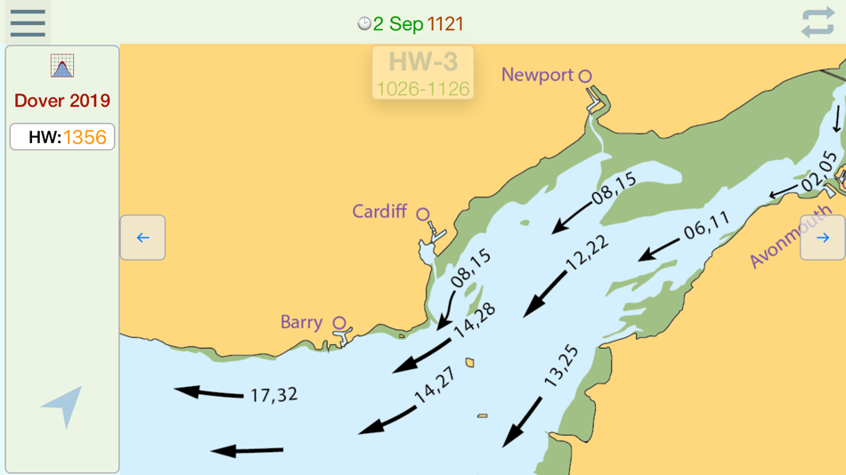
The nearest Dover HW time to the actual time is selected from the database and the relevant streams chart is displayed, together with the time period for which the chart is valid.
As the time moves to the next valid period, the relevant hourly chart is auto displayed.
* Swiping on the chart (or using navigation buttons), displays the next or previous tidal hour chart.
* Whenever the chart displayed is valid at the current time, the validity period is displayed in green.
* Pinching the screen zooms the chart
* Tapping the location button shows your actual boat position on the chart.
* Select Local or UTC time.
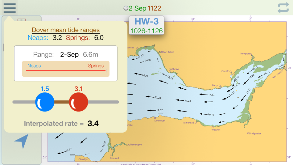
Select the rate tool to auto calculate the interpolated tidal rate when in between neaps and springs.
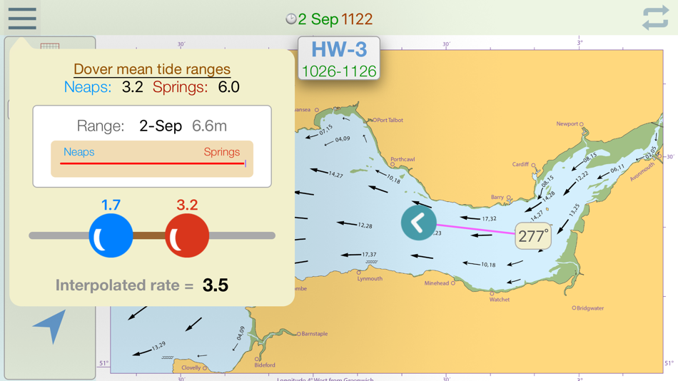
Select the 'Set' tool to measure the precise true course of any tidal stream arrow. (in-app purchase)
Select the 'CTS' tool to calculate a Course to Steer. (in-app purchase)
The app automatically selects the nearest Dover HW time of the day, but if you want to see data for the next or previous HW of the day, swipe forward or back to advance the tidal hour.
For forward planning, tap on the date to select a different date, whereupon data relevant to that date will be displayed.
螢幕擷取畫面


價錢
-
* 應用內購買 - 今天: 免費
- 最小值: 免費
- 最大值: 免費
追蹤票價
開發人員
- Navtech Software
- 平台: Android 應用程式 (16) iOS 應用程式 (21) iOS 遊戲 (1)
- 清單: 0 + 0
- 點數: 0 + 3 ¡
- 排名: 0
- 評測: 0
- 折扣: 0
- 影片: 2
- RSS: 訂閱
點數
0 ☹️
排名
0 ☹️
清單
0 ☹️
評測
成為第一個評論 🌟
其他資訊
聯絡人
- 個人網站:
 http://www.navsoft.co.uk
你可能還喜歡
-
- Bristol Maps
- iOS 應用程式: 地圖與導航 由: Chris Hager
- * 免費
- 清單: 0 + 0 排名: 0 評測: 0
- 點數: 1 + 14 (4.0) 版本: 3.13.1 Bristol Maps is designed specifically for commercial fishermen to navigate using the latest satellite imagery. Currently serving Bristol Bay and Copper River watersheds. Say goodbye to ⥯
-
- Bristol Tour Map of Banksy
- iOS 應用程式: 地圖與導航 由: Stephen Kempin
- $0.99
- 清單: 0 + 1 排名: 0 評測: 0
- 點數: 1 + 2 (3.0) 版本: 2.0.10 A Bristol native, graffiti artist Banksy has acquired worldwide fame for his thought provoking and satirical street art, and several original pieces remain in various locations around ... ⥯
-
- iStreams Channel Islands
- iOS 應用程式: 地圖與導航 由: Navtech Software
- * 免費
- 清單: 0 + 0 排名: 0 評測: 0
- 點數: 0 + 0 版本: 3.5 iStreams displays the valid hourly Channel Islands tidal stream atlas for the current real time , in reference to the time of high water at Dover... a smart app, fully functional ... ⥯
- 全新
- Banksy Trail Bristol
- iOS 應用程式: 地圖與導航 由: Marcel Petersen
- $0.99
- 清單: 0 + 0 排名: 0 評測: 0
- 點數: 0 + 0 版本: 1.0.1 Discover Bristol s world-famous street art with the Banksy Trail app. Find Banksy s most iconic works across the city. This app helps you plan your own walking tour to see Bristol s ... ⥯
-
- i-Boating: Marine Charts & Gps
- iOS 應用程式: 地圖與導航 由: Bist LLC
- 免費
- 清單: 0 + 1 排名: 0 評測: 0
- 點數: 1 + 13,617 (4.5) 版本: 162.0.0 This App offers access to Marine Charts for USA,Canada,UK/Ireland,Germany,Netherlands/Holland & Europe Rivers (Danube,Drava,Rhein etc). Coverage includes NOAA marine vector ... ⥯
-
- Nexar Classic
- iOS 應用程式: 地圖與導航 由: Nexar Inc.
- 免費
- 清單: 0 + 0 排名: 0 評測: 0
- 點數: 0 + 11,314 (4.4) 版本: 6.16.1 Compatible dash cams: Nexar Classic is the operational app of Nexar's WiFi dash cams: Nexar Beam, Nexar Pro, and other compatible models. For nexarOne and beam2 LTE dash cams, look for ⥯
-
- BaseMap: Hunting GPS Maps
- iOS 應用程式: 地圖與導航 由: BaseMap Inc
- * 免費
- 清單: 0 + 0 排名: 0 評測: 0
- 點數: 0 + 8,956 (4.6) 版本: 6.1.7 Guaranteed land ownership maps, mobile hunt planner with draw odds, industry leading GPS tools for hunters and outdoorsmen. OFFLINE GPS and TRACKING Cache maps for offline use without ... ⥯
-
- TroutRoutes: Fly Fishing App
- iOS 應用程式: 地圖與導航 由: onXmaps, Inc.
- 免費
- 清單: 0 + 0 排名: 0 評測: 0
- 點數: 3 + 3,691 (4.5) 版本: 5.3.1 TroutRoutes by onX is the #1 GPS mapping tool for trout streams and fly fishing. As the first mapping tool that includes interactive GPS fishing maps for every trout stream in the ... ⥯
-
- onWater Fish Maps & Forecast
- iOS 應用程式: 地圖與導航 由: OnWater, LLC
- 免費
- 清單: 0 + 0 排名: 0 評測: 0
- 點數: 0 + 2,048 (4.5) 版本: 2.9.6 Find New Places to Fish. Track Conditions. Fish Smarter. OnWater helps you discover where to fish, know when it's worth going, and log what works. Built for both fly and conventional ... ⥯
-
- Maptech iPlot
- iOS 應用程式: 地圖與導航 由: Nautical Solutions International, Inc.
- * $39.99
- 清單: 0 + 0 排名: 0 評測: 0
- 點數: 1 + 7 (2.1) 版本: 1.10.54 Maptech iPlot - Real Time Chart Plotting App The Maptech iPlot app is simple to use chart plotter app that utilizes many of the same routing functions that Maptech uses in their ... ⥯
-
- Trout Stream GPS - Fly Fishing
- iOS 應用程式: 地圖與導航 由: Distal Industries, LLC
- * 免費
- 清單: 0 + 0 排名: 0 評測: 0
- 點數: 0 + 3 (2.7) 版本: 6.0 WHAT IS TROUT STREAM GPS? Trout Stream GPS shows you where to park and fish on America's trout streams. The app is free to download, and maps are available for in-app purchase. FLY ... ⥯
-
- Street View 3D Live Google Map
- iOS 應用程式: 地圖與導航 由: Ekta Undhad
- 免費
- 清單: 0 + 1 排名: 0 評測: 0
- 點數: 1 + 197 (4.7) 版本: 1.0 Street View on Live Google Map brings 360-degree street-level exploration to your fingertips. Instantly view real-time maps, live GPS locations, satellite images, and high-quality ... ⥯
-
- Traveline SW Journey Planner
- iOS 應用程式: 地圖與導航 由: NATIONAL PUBLIC TRANSPORT INFORMATION LIMITED
- 免費
- 清單: 0 + 0 排名: 0 評測: 0
- 點數: 0 + 1 (5.0) 版本: 5.163 Traveline SW app the FREE journey planning app for all public transport in South West England and Great Britain. Data is updated every week and has timetables for all bus, coach, rail ... ⥯
-
- CycleParking
- iOS 應用程式: 地圖與導航 由: Daniel Johnson
- * 免費
- 清單: 0 + 0 排名: 0 評測: 0
- 點數: 0 + 0 版本: 1.6 CycleParking maps out over 32,000 places to park your bicycle throughout London, Bristol, Brighton and more. You'll see photos and key data about the parking space, and you can ... ⥯