| ผู้พัฒนา: | Mapitare Oy (4) | ||
| ราคา: | * ฟรี | ||
| การจัดอันดับ: | 0 | ||
| ความเห็น: | 0 เขียนความเห็น | ||
| รายการ: | 0 + 0 | ||
| แต้มแล: | 0 + 0 ¡ | ||
| App Store | |||
คำอธิบาย
")
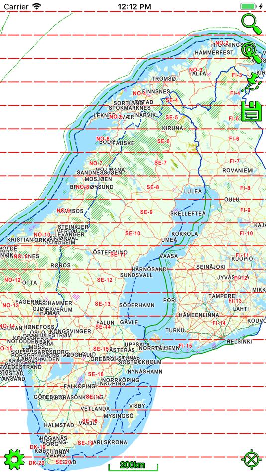
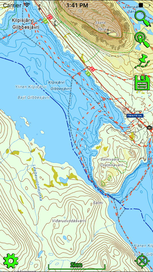
Mapitare is the first offline mapping software on the market that can be downloaded at once and is designed for critical work and demanding conditions on land, water and air.
The Mapitare terrain and sea mapping software is useful for outdoor enthusiasts, hikers, hunters, boaters and anyone who spends time outdoors. The digital map displays real-time location on a map. The risk of getting lost in mountainous terrain is the greatest when visibility weakens, and even an experienced hiker can lose his or her sense of direction on easy forested land. A ball indicating your position on the map will guide you back to the right path. The map on your phone screen is especially useful in bad weather, when the risk of getting lost is the greatest.
The unique Mapitare terrain and sea map does not require a telephone or electricity networks to function. All of the map data has been downloaded into the memory of the phone. Offline maps are suitable for critical work and function quickly and precisely in all conditions and everywhere within the map’s area. Therefore, weak telephone and data connections do not have any effect on the use of the Mapitare map. They can be used even after the telephone network has already faded. The operator is responsible for ensuring adequate battery life, and if necessary, should back it up with a power bank or backup battery.
In its entirety the data covers all of the land and sea areas of Finland, Sweden and Norway. In future the map data will expand even further.
We offer following in-app purchases:
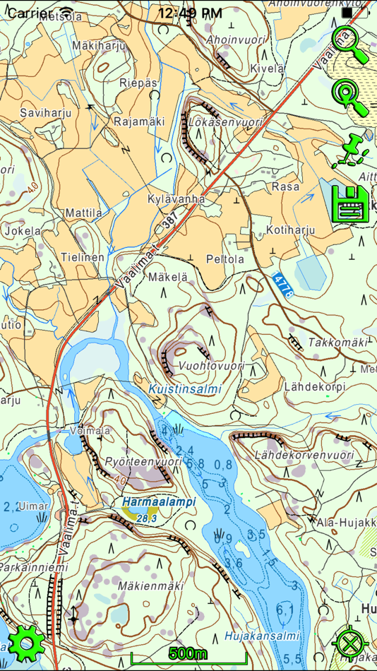
Terrain map of Finland
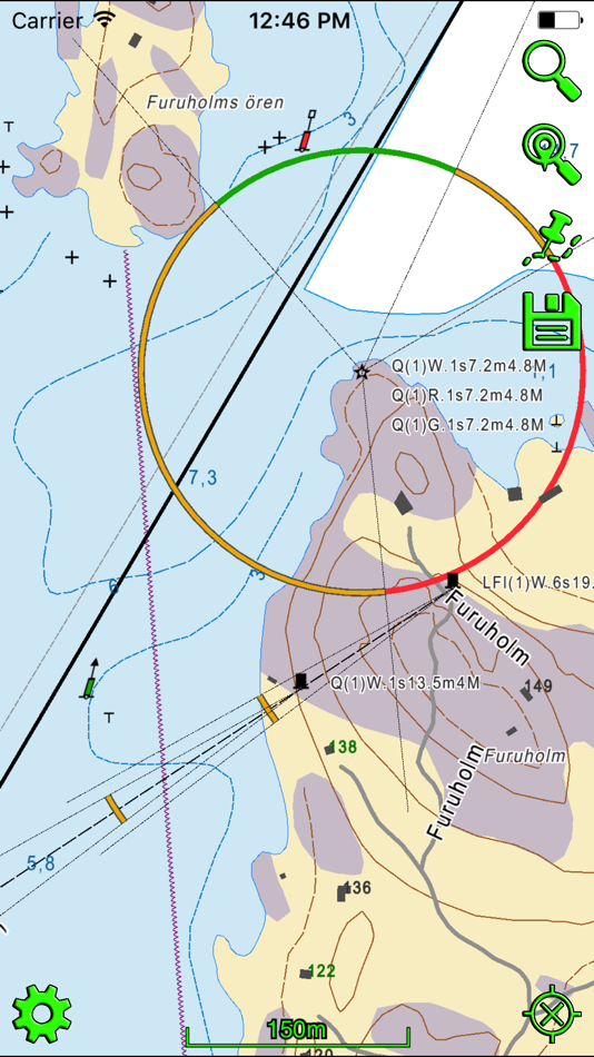
Sea map of Finland (requires terrain map of Finland)
Terrain map of Sweden
Sea map of Sweden (requires terrain map of Sweden)
Terrain map of Norway (includes depth contours)
Purchase includes routing on road, water way and snowmobile routes.
Data sources include:
National Survey
©Maanmittauslaitos, CC BY 4.0
©Lantmäteriet, CC BY 4.0
©Kartverket, CC BY 4.0
Road Management
©Liikennevirasto, CC BY 4.0
©Trafikverket, CC BY 4.0
©Kartverket, CC BY 4.0
Addresses
©Väestörekisterikeskus, CC BY 4.0
©Trafikverket, CC BY 4.0
©Kartverket, CC BY 4.0
Cadastral Registry (property)
©Finnish National Survey, CC BY 4.0
Land parcel register
©Agency for Rural Affairs, CC BY 4.0
OpenStreetMap
©OpenStreetMap contributors
©Creative Commons, CC BY-SA
Other data
©National Forestry
©SYKE
©LIPAS
Maritime Administration (requires terrain map)
©Liikenneviraston lisenssi No. 1604/07/07.03.01/2015
©Sjöfartsverket licence No. 17-00494
Mapitare Ltd
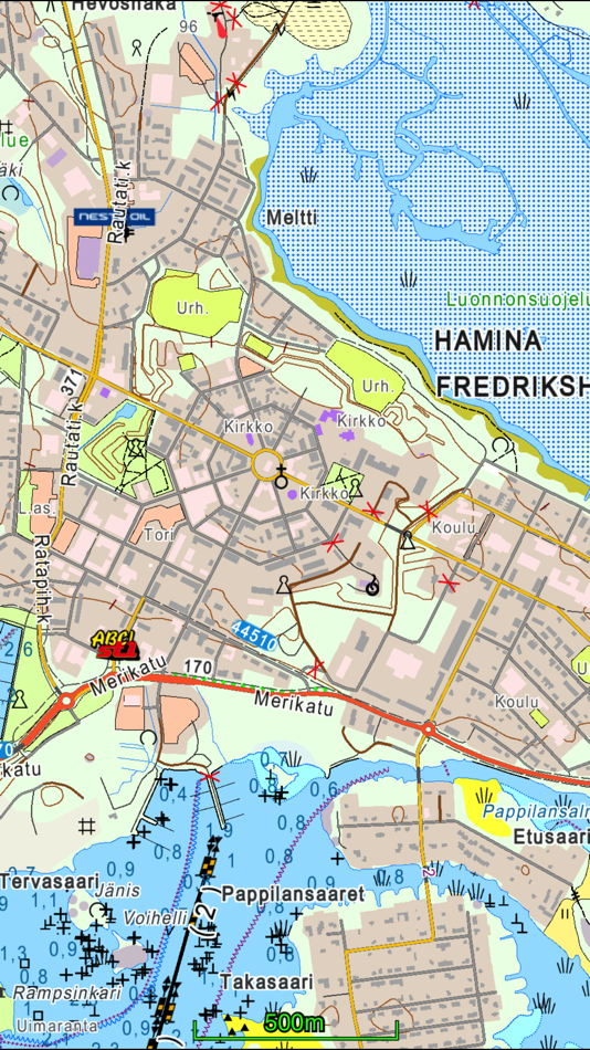
The company has over 15 years of experience in operational systems. As a result of the five years of development, a new mapping technology and reliable service model (tested) have been created. The map has no scale limit, and items are presented with production precision (cm).
Mapitare software has no dependencies on other suppliers. As a result, 100% change management can be done in a cost-effective way. The software products can be used in all systems and network connections are not needed for their use. Being independent of the environment and hardware guarantees a long life cycle for the technology.
Information about in-app purchases:
– Payment will be charged to iTunes Account at confirmation of purchase
– Subscription automatically renews unless auto-renew is turned off at least 24-hours before the end of the current period
– Account will be charged for renewal within 24-hours prior to the end of the current period
– Subscriptions may be managed by the user and auto-renewal may be turned off by going to the user's Account Settings after purchase
– Any unused portion of a free trial period, if offered, will be forfeited when the user purchases a subscription
Continued use of GPS running in the background can dramatically decrease battery life.
Mapitare Privacy Policy and Terms of Use: https://mapitare.fi/privacy-policy/
ภาพหน้าจอ
ราคา
-
* การซื้อภายในแอพ - วันนี้: ฟรี
- ต่ำสุด: ฟรี
- มากที่สุด: ฟรี
ติดตามราคา
ผู้พัฒนา
- Mapitare Oy
- แพลตฟอร์ม: Android แอป (3) iOS แอป (1)
- รายการ: 0 + 0
- แต้มแล: 0 + 0 ¡
- การจัดอันดับ: 0
- ความเห็น: 0
- ลดราคา: 0
- วิดีโอ: 3
- RSS: ติดตาม
แต้มแล
0 ☹️
การจัดอันดับ
0 ☹️
รายการ
0 ☹️
ความเห็น
แสดงรีวิวเป็นคนแรกเลย 🌟
ข้อมูลเพิ่มเติม
รายชื่อติดต่อ
- เว็บไซท์:
 https://www.mapitare.fi
คุณอาจชอบ
-
- SEA.AI
- iOS แอป: การนำทาง โดย: SEA.AI SAS
- ฟรี
- รายการ: 0 + 0 การจัดอันดับ: 0 ความเห็น: 0
- แต้มแล: 0 + 0 เวอร์ชัน: 2.3 Increase your vigilance and improve your safety at sea with the SEA.AI application, the user interface of the first marine optical system based on artificial vision. SEA.AI increases ... ⥯
-
- MineAR: Augmented Reality Map
- iOS แอป: การนำทาง โดย: Map Life, LLC
- * ฟรี
- รายการ: 0 + 0 การจัดอันดับ: 0 ความเห็น: 0
- แต้มแล: 0 + 5 (5.0) เวอร์ชัน: 2.40.15 Data you can grasp. As a geoscience professional, we know you want an easier way to see your GIS data while you re in the field. MineAR allows you to do exactly that. Our app ... ⥯
-
- Map Switch: Convert Map Links!
- iOS แอป: การนำทาง โดย: Pavly Paules
- * ฟรี
- รายการ: 0 + 0 การจัดอันดับ: 0 ความเห็น: 0
- แต้มแล: 9 + 2 (5.0) เวอร์ชัน: 2.6.1 Map Switch - Open map links in your favourite map service Transform your map experience with Map Switch, the ultimate tool for converting between Apple Maps, Google Maps, Waze, Bing ... ⥯
-
- Map LT
- iOS แอป: การนำทาง โดย: Taylan Atasoy
- ฟรี
- รายการ: 0 + 0 การจัดอันดับ: 0 ความเห็น: 0
- แต้มแล: 0 + 0 เวอร์ชัน: 4.0 Map LT is a cutting-edge navigation and mapping application designed for users who want to easily find their way around World. With its user-friendly interface and comprehensive ... ⥯
-
- Memory-Map for All
- iOS แอป: การนำทาง โดย: Memory-Map
- ฟรี
- รายการ: 0 + 0 การจัดอันดับ: 0 ความเห็น: 0
- แต้มแล: 0 + 9 (4.9) เวอร์ชัน: 2.0.5 Download maps for Offline GPS Navigation. No mobile data connection required. Your favorite maps and charts from OS, Hema, NOAA, and many more. Immersive 3D World map view Fully ... ⥯
-
- Map Map - Your Map on a Map
- iOS แอป: การนำทาง โดย: Ben Roberts
- * ฟรี
- รายการ: 0 + 0 การจัดอันดับ: 0 ความเห็น: 0
- แต้มแล: 0 + 2 (5.0) เวอร์ชัน: 2.3 Welcome to Map Map Your Personal Cartographer! Ever wished you could see where you were on a trail map, building diagram, or any other visual reference? How about knowing where a trail ⥯
-
- Map MateAI- Navigate with Chat
- iOS แอป: การนำทาง โดย: Ahmet Erkin Arıkan
- ฟรี
- รายการ: 0 + 0 การจัดอันดับ: 0 ความเห็น: 0
- แต้มแล: 0 + 0 เวอร์ชัน: 1.0.3 Struggling to decide where to go? Let our app guide you! Whether you're searching for a cozy café, an exciting spot to explore, or a pharmacy on duty, we ve got you covered. Simply ... ⥯
-
- Map Tells...!
- iOS แอป: การนำทาง โดย: Yuriko Kimura
- ฟรี
- รายการ: 0 + 0 การจัดอันดับ: 0 ความเห็น: 0
- แต้มแล: 0 + 0 เวอร์ชัน: 3.4 "Map Tells...! is an app that shares your location with your companion by providing a Google Maps link and photo. The mail receiver follows the directions (on the map or through a ... ⥯
-
- Map It Realtour
- iOS แอป: การนำทาง โดย: DKP Productions LLC
- ฟรี
- รายการ: 0 + 0 การจัดอันดับ: 0 ความเห็น: 0
- แต้มแล: 0 + 3 (5.0) เวอร์ชัน: 2.0.2 Map It Realtour® / Mobile Application for Realtors With New Map It Client Version for Their Clients Map It Realtour® is a new and unique Real Estate App for Agents worldwide, that was ... ⥯
-
- Map Tools
- iOS แอป: การนำทาง โดย: Modular Machines LLC
- $1.99
- รายการ: 0 + 0 การจัดอันดับ: 0 ความเห็น: 0
- แต้มแล: 0 + 1 (5.0) เวอร์ชัน: 6.1 Map Tools supports coordinate systems and map projections for 232 datums, including WGS84, NAD27, NAD83, ED50, OSGB36, EGSA87, AGD66, AGD84, GDA94, NZGD2000, NZGD1949, and many more. ... ⥯
-
- Map Points
- iOS แอป: การนำทาง โดย: Sachin Deshpande
- $0.99
- รายการ: 0 + 0 การจัดอันดับ: 0 ความเห็น: 0
- แต้มแล: 0 + 0 เวอร์ชัน: 1.2 Map Points is an app to store your favorite map locations. You can use it while hiking to mark pinpoint locations that you want to remember. Or you can drop a pin to mark the secret ... ⥯
-
- Map Snapper
- iOS แอป: การนำทาง โดย: Mark Malone
- * ฟรี
- รายการ: 0 + 0 การจัดอันดับ: 0 ความเห็น: 0
- แต้มแล: 0 + 0 เวอร์ชัน: 2.1 Plan orienteering events by placing and fine tuning control locations in the field. Create your own instant offline maps. Create geolocated maps from photos and pictures, either with ... ⥯
-
- Map Link Converter
- iOS แอป: การนำทาง โดย: POORNA S JAYASINGHE
- $4.99
- รายการ: 0 + 0 การจัดอันดับ: 0 ความเห็น: 0
- แต้มแล: 0 + 0 เวอร์ชัน: 1.0 Seamlessly open any map link in your preferred navigation app. Map Link Converter is the ultimate tool for converting and opening map URLs across different mapping platforms. Whether ... ⥯
-
- Map Plus
- iOS แอป: การนำทาง โดย: Miocool Inc.
- ฟรี
- รายการ: 1 + 1 การจัดอันดับ: 0 ความเห็น: 0
- แต้มแล: 0 + 613 (4.6) เวอร์ชัน: 2.9.0 The most powerful and versatile tool for viewing and editing custom maps, surveying, editing or managing mass of your geography data. You can use Map Plus as a professional GIS tool ... ⥯