| 開發人員: | Marco Palaferri (8) | ||
| 價錢: | $19.99 | ||
| 排名: | 0 | ||
| 評測: | 0 寫評論 | ||
| 清單: | 0 + 0 | ||
| 點數: | 0 + 0 ¡ | ||
| App Store | |||
描述
")
Tired of apps renting your maps every year? Worried about your secret fishing spots being tracked or sold? It’s time to take back control.
Marine Navigation is the GPS chartplotter you buy once and own for life. No hidden fees, no forced subscriptions. Since 2009, sailors, fishermen, and sea lovers have trusted us for reliable, offline navigation that respects their privacy.
CHOOSE YOUR WAY TO NAVIGATE
- Try Free: Download Marine Navigation Lite to explore the basics.
- Full Version (One-Time Purchase): Get the complete offline chartplotter that’s yours forever.
- Go PRO (Optional Subscription): Unlock professional-grade tools and navigate without limits.
Your choice: own it once, or subscribe for more — total freedom.
GO PRO — THE ULTIMATE NAVIGATION
For the serious navigator, we built something extraordinary. The PRO version is more than just features; it's a commitment to professional-grade technology, passionately built by a single developer.
- PROPRIETARY S57 ENGINE (NEW): This is our masterpiece. Our custom S57 renderer brings official Electronic Navigational Charts (ENC) to your device with a speed and detail once reserved for systems costing thousands. This isn't a licensed feature; it's core technology built for performance.
- UNLIMITED CUSTOM MAPS: Our most revolutionary feature, supercharged. Scan a paper chart, import a satellite image of a wreck, or even use a treasure map. Our powerful georeferencing tool lets you turn any image into a fully navigable, offline chart in minutes. Your knowledge, mapped.
- GLOBAL OFFLINE TIDES: Accurate tidal data for any point on the map, calculated on your device. No internet needed, powered by the high-precision FES2022b global model.
- ADVANCED TOOLS: Overlay multiple maps, adjust transparency, and gain a level of control that competitors simply cannot match.
YOUR DATA IS SACRED
We respect your privacy. We don’t track you. We don’t analyze your locations. We never sell your data. Everything you save stays safely on your device. Your fishing spots remain yours — always.
FULL VERSION — EVERYTHING YOU NEED
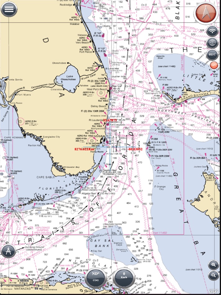
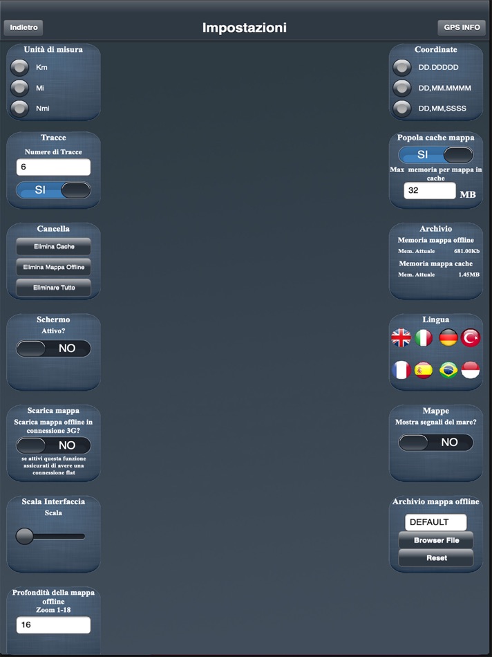
- RELIABLE OFFLINE MAPS: Download your charts and navigate with confidence far from shore. Our entire download system has been rebuilt from the ground up based on user feedback for total clarity and control.
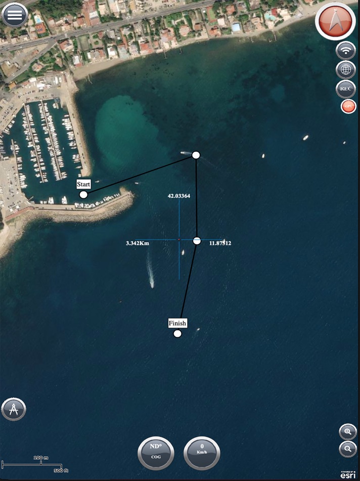
- COMPLETE GPS NAVIGATION: Create routes, record tracks, set a visual anchor alarm, use the compass (true/magnetic), and monitor your speed and direction.
- NEW! ADVANCED VISUAL WAYPOINTS: Take total control of your map. Organize your spots with a library of custom icons and colors, then go beyond a simple pin: turn your chart into an intelligent log. Tag any location with the exact bait that worked, the type of fishing, catch details, and other crucial conditions.
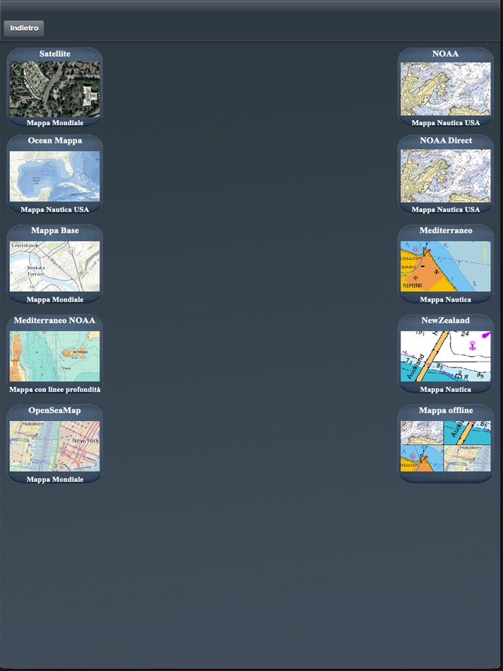
- WIDE CHART SELECTION: Access NOAA Raster & ENC, ESRI Satellite Imagery, OpenSeaMap, Bathymetric Maps, and more.
- USEFUL TOOLS: Basic weather, moon & sun phases, GPX import/export.
WHY CHOOSE MARINE NAVIGATION?
- Freedom of Choice: Buy once for life, or subscribe to PRO — you decide.
- Privacy First: Your data stays on your device, period.
- Unmatched Control: From official S57 charts to your own custom maps.
- Trusted by Navigators Worldwide: Reliable and independent since 2009.
IMPORTANT NOTICE
Good seamanship requires the use of official charts. Marine Navigation is for use with other charts and cannot replace official charts. Use at your own risk.
SUBSCRIPTION INFORMATION
- The PRO subscription renews automatically unless turned off at least 24 hours before the end of the current period.
- You can manage or disable auto-renew in your iTunes Account Settings after purchase.
---
Learn more on our official website:
www.fishpoints.net
Terms of Use:
http://www.fishpoints.net/eula/
Privacy Policy:
http://www.fishpoints.net/privacy-policy/
Try Marine Navigation and take the helm of your journey. The sea is yours.
螢幕擷取畫面
新功能
- 版本: 14.0.21
- 發佈日期:
- INTRODUCING: THE S57/ENC PRO ENGINE This changes everything. We built our own S57/ENC rendering engine from the ground up. This isn’t a licensed feature; it’s core technology crafted for one reason: to give you the fastest, most detailed, and most impossibly responsive professional chart experience on any mobile device. Import official S57 charts and navigate with precision that was once unthinkable. (PRO Version)
YOUR KNOWLEDGE, MAPPED: CUSTOM MAP IMPORT The feature you’ve been waiting for. Turn any image into a fully navigable, offline chart. Scan a nautical chart, import a satellite image of a wreck, or even use a hand-drawn map of a secret spot. Your personal knowledge, finally on your chartplotter.
Full Version: Get started by importing your first custom map.
PRO Version: Unleash the full potential with unlimited, high-resolution custom maps.
NEW — THE ANGLER'S SMART LOGBOOK Stop just "marking spots." Our new Advanced Waypoints turn your chart into an intelligent fishing log. Go beyond a simple pin: tag any location with the exact bait that worked, the type of fishing (trolling, jigging), catch details, and crucial conditions. It’s no longer just a waypoint—it’s your personal database for repeatable success on the water.
REBUILT & REFINED: PRO-GRADE CORE TOOLS We’ve overhauled the essentials to give you total control.
New Visual Offline Maps: A completely rebuilt, visual downloader. See exactly what you've downloaded on the map and manage storage with total, transparent control.
Advanced Anchor Monitor: More than an alarm, it's your visual anchor watch. Set your anchor point, see the clear monitoring circle, and get instant drift alerts. It's peace of mind, visualized.
NEW FOR PRO: OFFLINE TIDES & ALMANAC Two new professional tools for the serious navigator.
Offline Tides (PRO): Get hyper-accurate tidal forecasts for any point on the map, far from any internet connection. Powered by the high-precision FES2022b model for serious planning.
Sun & Moon Almanac: Master celestial awareness. An interactive Sun Dial shows the 24-hour sun arc (including critical twilight phases) and a Moon Altitude Chart plots its entire path. Perfect for planning night passages and predicting light.
This update is our commitment made real: to provide independent navigators with the most powerful, private, and flexible tools on the water.
Update now and take command of your navigation.
價錢
- 今天: $19.99
- 最小值: $7.99
- 最大值: $19.99
追蹤票價
開發人員
- Marco Palaferri
- 平台: Android 應用程式 (4) iOS 應用程式 (4)
- 清單: 0 + 0
- 點數: 1 + 2,911 ¡
- 排名: 0
- 評測: 0
- 折扣: 0
- 影片: 2
- RSS: 訂閱
點數
0 ☹️
排名
0 ☹️
清單
0 ☹️
評測
成為第一個評論 🌟
其他資訊
- 版本: 14.0.21
- 類別 :
iOS 應用程式›地圖與導航 - OS:
iPad,iPhone,iOS 18.0 以上版本 - 大小:
99 Mb - 支援的語言 :
Chinese,Czech,Danish,Dutch,English,Finnish,French,German,Greek,Hebrew,Indonesian,Italian,Japanese,Korean,Malay,Norwegian,Polish,Portuguese,Russian,Spanish,Swedish,Thai,Turkish,Vietnamese - 內容分級:
17+ - App Store 評分:
0 - 發佈日期:
- 發行日期:
聯絡人
- 🌟 分享
- App Store
你可能還喜歡
-
- Marine Navigation-USA Lake Map
- iOS 應用程式: 地圖與導航 由: Bist LLC
- $24.99
- 清單: 0 + 0 排名: 0 評測: 0
- 點數: 0 + 19 (4.2) 版本: 150.0.0 Marine Navigation App offers access to NOAA marine vector charts, freshwater lake maps, USACE inland river maps. Only marine GPS app to have route assistance with Voice Prompts for ... ⥯
-
- Marine Navigation Lite
- iOS 應用程式: 地圖與導航 由: Marco Palaferri
- * 免費
- 清單: 0 + 0 排名: 0 評測: 0
- 點數: 0 + 0 版本: 14.0.21 MARINE NAVIGATION Offline GPS Chartplotter You Own Forever Tired of apps renting your maps every year? Worried about your secret fishing spots being tracked or sold? It s time to take ... ⥯
-
- iNavX: Marine Navigation
- iOS 應用程式: 地圖與導航 由: NavX Studios LLC
- 免費
- 清單: 0 + 0 排名: 0 評測: 0
- 點數: 7 + 20,730 (4.8) 版本: 5.8.1 Marine navigation is made easy with iNavX - the world's #1 handheld Chartplotter. Access marine charts, maps, weather, AIS and more! iNavX is the only app to give you complete ... ⥯
-
- PRO CHARTS - Marine Navigation
- iOS 應用程式: 地圖與導航 由: MiraTrex, Inc.
- 免費
- 清單: 0 + 0 排名: 0 評測: 0
- 點數: 0 + 8,378 (4.5) 版本: 5.70 MiraTrex PRO CHARTS™ is a powerful, yet easy-to-use marine navigation system. Whether you re a fisherman, weekend cruiser, sailor, diver, jet-skier, or an offshore captain needing to ... ⥯
-
- TZ iBoat – Marine Navigation
- iOS 應用程式: 地圖與導航 由: Nobeltec, Inc.
- 免費
- 清單: 0 + 0 排名: 0 評測: 0
- 點數: 3 + 770 (4.6) 版本: 3.3.3 Navigate the seas with the most complete marine charts for coastal boating, sailing, and fishing with or without internet. GPS, anchoring, radar, AIS Online, tides & tidal currents... ... ⥯
-
- mKart Marine Navigation
- iOS 應用程式: 地圖與導航 由: GEOPHONE GROUP INTERNATIONAL Oy
- 免費
- 清單: 0 + 0 排名: 0 評測: 0
- 點數: 1 + 3 (2.3) 版本: 1.8.727 mKart 3D marine App is for safe and comfortable navigation. Product Highlights: WEB CONSOLE: E-shop; ENCs and cartographic products Catalogue; Portfolio optimization; Fleet management; ⥯
-
- Marine Traffic: Ship Tracker
- iOS 應用程式: 地圖與導航 由: ISRAFIL YIGIT
- 免費
- 清單: 0 + 0 排名: 0 評測: 0
- 點數: 0 + 15 (4.8) 版本: 2.1.5 Marine Traffic: Ship Tracker is the world's most powerful real-time vessel tracking app, putting global maritime data at your fingertips! Track ships, yachts, and port activity ... ⥯
-
- Navigation Marine
- iOS 應用程式: 地圖與導航 由: Andrea Bisegna
- 免費
- 清單: 0 + 0 排名: 0 評測: 0
- 點數: 0 + 0 版本: 1.8 An helpful navigation marine tool for sailors, yachts and boats. This app contains a set of nautical applications: - Speedometer in knots, mph or km/h, Course over Ground; - Position; ... ⥯
-
- Marine Chart Symbols
- iOS 應用程式: 地圖與導航 由: Imray
- $4.99
- 清單: 0 + 0 排名: 0 評測: 0
- 點數: 0 + 3 (1.7) 版本: 2.1.2 Complete reference for symbols, abbreviations and terms used in marine charts. Useful as an aid for teaching and learning, or as reminder for experienced sailors and sea cartography ... ⥯
-
- Marine Contract Tracker
- iOS 應用程式: 地圖與導航 由: Stanislav Soroka
- $1.99
- 清單: 0 + 0 排名: 0 評測: 0
- 點數: 0 + 0 版本: 1.0 Marine Contract Tracker is the ultimate tool for seafarers to stay in control of their contracts. Whether you're at sea or ashore, this app helps you visualize your progress with a ... ⥯
-
- Navigation Compass & GPS
- iOS 應用程式: 地圖與導航 由: Alexander Deplov
- 免費
- 清單: 3 + 4 排名: 5 (1) 評測: 0
- 點數: 33 + 2,800 (4.6) 版本: 3.0.3 ** Best New Navigation Apps ** Apple ** It s the compass reinvented with walking directions, navigational bookmarks, and a simple parked-car locator all in a friendly design. ** App ... ⥯
-
- Argo - Boating Navigation
- iOS 應用程式: 地圖與導航 由: Argo Navigation, LLC
- * 免費
- 清單: 0 + 1 排名: 0 評測: 0
- 點數: 0 + 5,938 (4.9) 版本: 2.14.3 Argo™ is an easy-to-use navigation and social boating app FREE to download and FREE to use! Find and route to new destinations anywhere in North America, track your boat trips, see ... ⥯
-
- Marine Compass Pro
- iOS 應用程式: 地圖與導航 由: DF Tech Consulting AB
- $1.99
- 清單: 0 + 0 排名: 0 評測: 0
- 點數: 2 + 0 版本: 1.1.9 Navigate the open waters with confidence using Marine Compass, your ultimate boating companion. Get real-time information on your heading, speed in knots, latitude, and longitude. Set ... ⥯
-
- Marine Radar
- iOS 應用程式: 地圖與導航 由: 株式会社フルノソフテック
- 免費
- 清單: 0 + 0 排名: 0 評測: 0
- 點數: 1 + 12 (2.7) 版本: 2.1.3 Descriptions: This Marine Radar App, in connection with the Furuno Wireless Radar Sensor DRS4W, enables to view and control Radar images on iOS devices. How to use: Get the Marine ... ⥯