描述
")
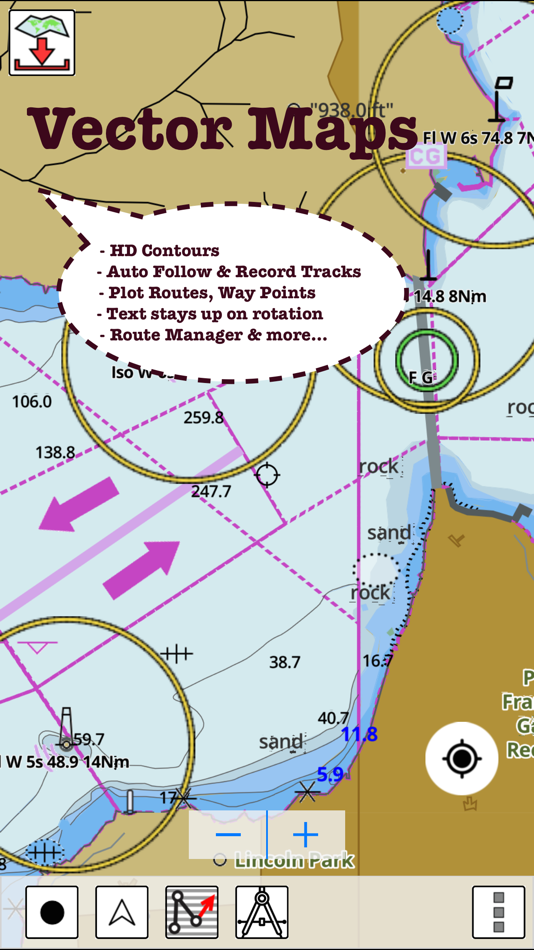
* Hardware/GPU accelarated vector charts (text stays upright on rotation).
* Voice Prompts for marine navigation (requires GPS )
* 1ft / 3ft depth contour maps for anglers for selected lake maps.
* Supports GPX/KML for boating route editing/import.
* Tide & Currents prediction.
* Seamless chart quilting of marine charts
* Enter way points
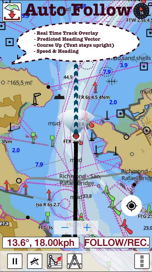
* Record tracks, Autofollow with realtime track overlay
* Voice Prompts for marine navigation (requires GPS )
-prompts when approaching a boating route marker
-Continous distance and ETA updates
-Alerts when sailing/boating off route
-Alerts when boating in wrong direction
*Route Editing/Creation
-Create routes from scratch
-Edit existing GPX/KML routes.
-Add custom description to any route point.
-Drop markers along route.
* Offline NOAA marine, lake & river charts
-Visually download using grid
-Textual search
* Tide & Currents
- High / Low tides.
- Tidal Currents.
- Active currents stations.
*Seamless chart quilting of marine charts
*Distance Bearing tool
*Create custom way points
- Using GPS
-Select point on map
-Manually enter latitude & longitude coordinates
*Pan/Zoom/My Location
* Record Marine GPS tracks
* View tracks overlay
* Live track animation
* Track analytics/stats
* Export GPX trcks.
-Export to SDCard
-Share GPX tracks with friends.
* Auto Follow Mode (Course up)
-Continuously updates boat's location on chart
- Adjustable update frequency
Sample Nautical Charts (please visit http://gpsnauticalcharts.com/main/folio-catalog-nautical-charts-app for complete list)
SUGARLOAF KEY-KEY WEST
PORT RICHEY TAMPA BAY - CLEARWATER HBR
EAST BAY-WEST BAY FLORIDA
ST JOSEPH, ST ANDREW BAYS
INTRACOASTAL WATERWAY MATECUMBE-GRASSY KEY
CHESAPEAKE BAY CAPE CHARLES-NORFOLK HARBOR
ANCLOTE KEYS-CRYSTAL RIVER
ST JOSEPH SOUND
MIAMI HARBOR
Minnesota lakes - Kabetogama, Minnetonka, Waconia,Leech,Mille Lacs
Lake Keowee,Jocassee,Hartwell,Greenwood,Lake Murray
Mark Twain,Ozarks,Table Rock
Lake St. Clair
Lake Kentucky
KEY WEST-THE MISSISSIPPI RIVER
SAN PEDRO CHANNEL
LAKE MICHIGAN STONY LAKE-POINT BETSIE
APALACHICOLA BAY-CAPE SAN BLAS
EAST CAPE-MORMON KEY
CAPE HENLOPEN-INDIAN RIVER INLET
CHESAPEAKE BAY CAPE HENRY-THIMBLE SHOAL LIGHT
DULUTH-SUPERIOR HARBOR
MONHEGAN ISLAND-CAPE ELIZABETH
LAKE ONTARIO - CLAYTON-FALSE DUCKS ISL
Lake Winnipesaukee
SAN FRANCISCO ENTRANCE
MIAMI-MARATHON, FLORIDA BAY
CAPE MAY-FENWICK ISLAND
MISSISSIPPI RIVER-GALVESTON
CAPE CANAVERAL-KEY WEST
DELAWARE RIVER WILMINGTON-PHILADELPHIA
FLORIDA KEYS SOMBRERO KEY-SAND KEY
SAN PABLO BAY
RAINY LAKE BIG ISLAND MINN-OAKPOINT ISL ONT
INTRACOASTAL WATERWAY - BISCAYNE BAY
EVERGLADES NTL PARK - SHARK RVR-LOSTMANS RVR
MIAMI-MARATHON & FLORIDA BAY
BLACKBURN BAY
LAKE HURON
LAKE TAHOE
STRAITS OF MACKINAC
NORFOLK HARBOR & ELIZABETH RIVER
SAN DIEGO-SANTA ROSA ISLAND
DELAWARE BAY
CHOPTANK RIVER CAMBRIDGE-GREENSBORO
FORT LAUDERDALE PORT EVERGLADES
ST SIMONS SOUND-TOLOMATO RIVER
CHESAPEAKE DELAWARE CANAL
CAPE MENDOCINO
STRAIT OF JUAN DE FUCA ENTRANCE
PORT RICHEY CLEARWATER HBR
PAMPANO BEACH-HALLADALE FLORIDA
LAKE ERIE
LAKE MICHIGAN INCLUDING GREEN BAY
MAIMI-MARATHON and FLORIDA BAY
SANTA CATALINA ISLAND
APALACHICOLA BAY-LAKE WIMICO
Battery Disclaimer:
"Continued use of GPS running in the background can dramatically decrease battery life."
螢幕擷取畫面


新功能
- 版本: 150.0.0
- 發佈日期:
- - Relief Shading
- Automatic Routing
- Lake Temperatures
- Compiled with laest version of Xcode
價錢
- 今天: $24.99
- 最小值: $19.99
- 最大值: $24.99
追蹤票價
開發人員
- Bist LLC
- 平台: iOS 應用程式 (12) macOS 應用程式 (2) Windows 應用程式 (7)
- 清單: 2 + 1
- 點數: 3 + 17,881 ¡
- 排名: 0
- 評測: 0
- 折扣: 0
- 影片: 0
- RSS: 訂閱
點數
0 ☹️
排名
0 ☹️
清單
0 ☹️
評測
成為第一個評論 🌟
其他資訊
聯絡人
你可能還喜歡
-
- Marine Navigation
- iOS 應用程式: 地圖與導航 由: Marco Palaferri
- $19.99
- 清單: 0 + 0 排名: 0 評測: 0
- 點數: 0 + 0 版本: 14.0.2 MARINE NAVIGATION Offline GPS Chartplotter You Own Forever Tired of apps renting your maps every year? Worried about your secret fishing spots being tracked or sold? It s time to take ... ⥯
-
- Marine Navigation - Canada
- iOS 應用程式: 地圖與導航 由: Bist LLC
- $28.99
- 清單: 0 + 0 排名: 0 評測: 0
- 點數: 0 + 2 (4.5) 版本: 136.0.0 GPS Marine Charts App offers access to charts covering Canada (derived from CHS data). Only marine GPS app to have route assistance with Voice Prompts for marine navigation. It has ... ⥯
-
- GPS Navigation & Live Map
- iOS 應用程式: 地圖與導航 由: Amit Lakhani
- 免費
- 清單: 0 + 0 排名: 0 評測: 0
- 點數: 0 + 203 (4.1) 版本: 2.8 GPS Navigation with voice navigation, live map, traffic, offline Gps & direction. GPS Navigation with voice navigation, live map, traffic, offline Gps & direction. Map GPS navigation ... ⥯
-
- Lake County PASSAGE
- iOS 應用程式: 地圖與導航 由: Lake County, Illinois
- 免費
- 清單: 0 + 0 排名: 0 評測: 0
- 點數: 0 + 810 (4.8) 版本: 3.0.5 PASSAGE is an Intelligent Transportation System, designed to provide motorists real time traffic congestion information for Lake County, IL. PASSAGE app includes: * Incident ... ⥯
-
- iNavX: Marine Navigation
- iOS 應用程式: 地圖與導航 由: NavX Studios LLC
- 免費
- 清單: 0 + 0 排名: 0 評測: 0
- 點數: 7 + 20,632 (4.8) 版本: 5.8.1 Marine navigation is made easy with iNavX - the world's #1 handheld Chartplotter. Access marine charts, maps, weather, AIS and more! iNavX is the only app to give you complete ... ⥯
-
- PRO CHARTS - Marine Navigation
- iOS 應用程式: 地圖與導航 由: MiraTrex, Inc.
- 免費
- 清單: 0 + 0 排名: 0 評測: 0
- 點數: 0 + 8,360 (4.5) 版本: 5.70 MiraTrex PRO CHARTS™ is a powerful, yet easy-to-use marine navigation system. Whether you re a fisherman, weekend cruiser, sailor, diver, jet-skier, or an offshore captain needing to ... ⥯
-
- Squam Lake Map
- iOS 應用程式: 地圖與導航 由: Ryan Grady
- $1.99
- 清單: 0 + 0 排名: 0 評測: 0
- 點數: 0 + 2 (5.0) 版本: 1.4.23 This app shows your current position along with all the buoys on Squam Lake, and it works offline! It contains a compass for to help navigate the buoys. And It also contains a list of ... ⥯
-
- TZ iBoat – Marine Navigation
- iOS 應用程式: 地圖與導航 由: Nobeltec, Inc.
- 免費
- 清單: 0 + 0 排名: 0 評測: 0
- 點數: 3 + 760 (4.6) 版本: 3.3.3 Navigate the seas with the most complete marine charts for coastal boating, sailing, and fishing with or without internet. GPS, anchoring, radar, AIS Online, tides & tidal currents... ... ⥯
-
- mKart Marine Navigation
- iOS 應用程式: 地圖與導航 由: GEOPHONE GROUP INTERNATIONAL Oy
- 免費
- 清單: 0 + 0 排名: 0 評測: 0
- 點數: 1 + 3 (2.3) 版本: 1.8.727 mKart 3D marine App is for safe and comfortable navigation. Product Highlights: WEB CONSOLE: E-shop; ENCs and cartographic products Catalogue; Portfolio optimization; Fleet management; ⥯
-
- GPS Live Navigation & Live Map
- iOS 應用程式: 地圖與導航 由: Erasoft Technology
- 免費
- 清單: 0 + 0 排名: 0 評測: 0
- 點數: 0 + 129 (3.2) 版本: 4.6 GPS Live Navigation & FreeMaps with voice navigation, live map, traffic, offline Gps & direction. Map GPS navigation route directions location live car driving satellite view. Maps is ... ⥯
-
- MineAR: Augmented Reality Map
- iOS 應用程式: 地圖與導航 由: Map Life, LLC
- * 免費
- 清單: 0 + 0 排名: 0 評測: 0
- 點數: 0 + 5 (5.0) 版本: 2.40.15 Data you can grasp. As a geoscience professional, we know you want an easier way to see your GIS data while you re in the field. MineAR allows you to do exactly that. Our app ... ⥯
-
- Memory-Map for All
- iOS 應用程式: 地圖與導航 由: Memory-Map
- 免費
- 清單: 0 + 0 排名: 0 評測: 0
- 點數: 0 + 9 (4.9) 版本: 2.0.5 Download maps for Offline GPS Navigation. No mobile data connection required. Your favorite maps and charts from OS, Hema, NOAA, and many more. Immersive 3D World map view Fully ... ⥯
-
- Marine Traffic: Ship Tracker
- iOS 應用程式: 地圖與導航 由: ISRAFIL YIGIT
- 免費
- 清單: 0 + 0 排名: 0 評測: 0
- 點數: 0 + 1 (3.0) 版本: 2.1.5 Marine Traffic: Ship Tracker is the world's most powerful real-time vessel tracking app, putting global maritime data at your fingertips! Track ships, yachts, and port activity ... ⥯
-
- Map Switch: Convert Map Links!
- iOS 應用程式: 地圖與導航 由: Pavly Paules
- * 免費
- 清單: 0 + 0 排名: 0 評測: 0
- 點數: 9 + 2 (5.0) 版本: 2.6.1 Map Switch - Open map links in your favourite map service Transform your map experience with Map Switch, the ultimate tool for converting between Apple Maps, Google Maps, Waze, Bing ... ⥯