| Developer: | The Other Hat (12) | ||
| Price: | $1.99 | ||
| Rankings: | 0 | ||
| Reviews: | 0 Write a Review | ||
| Lists: | 0 + 0 | ||
| Points: | 0 + 2 (3.5) ¡ | ||
| App Store | |||
Description
")
************ FEATURES and BENEFITS ************
- Perfect for reference, learning & revision
- Hi-res graphics
- Tap & Enlarge feature for greater detail
- Fully searchable index to all the symbols
- Always with you on your iPhone or iPad
- No internet connection needed
************ Plus FREE Bonus Content from "Safe Skipper" ************
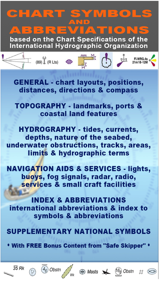
"CHART SYMBOLS & ABBREVIATIONS" provides quick reference to the "INT 1" symbols specified by the International Hydrographic Organization (IHO) for use on International marine charts.
There are five main sections in this app, each with lettered sub-sections organized into categories to guide users through the hundreds of symbols. The main sections are:
GENERAL - chart layouts, positions, distances, directions and compass.
TOPOGRAPHY - landmarks, ports and coastal land features.
HYDROGRAPHY - tides, currents, depths, nature of the seabed, underwater obstructions, tracks, areas, limits and hydrographic terms.
NAVIGATION AIDS & SERVICES - lights, buoys, fog signals, radar, radio, services and small craft facilities.
INDEX & ABBREVIATIONS - international abbreviations and index to symbols and abbreviations.
SUPPLEMENTARY NATIONAL SYMBOLS Supplementary National Symbols for nautical charts used by the United States and United Kingdom are included at the end of each section.
************* FREE Bonus Content from "Safe Skipper" *****************************
A bonus section has tips on how to deal with emergencies including: Abandon ship; Dismasting; Distress Signals; Engine Failure; Fire Fighting; Flares; Getting a tow; Helicopter rescue; Holed hull; Man overboard; Medical emergency; Mayday; Panpan; Securité.
INDEX The index is an A-Z of symbols and abbreviations and enables the user to quickly look up the symbols and see them in context with others in the same categories.
This app is based on the United Kingdom Hydrographic Office's print publication "Chart 5011 (INT 1) EDITION 2" Admiralty Charts Publication and "Chart No.1 United States of America Nautical Chart Symbols, Abbreviations and Terms".
NOTE: ECDIS symbols used to display Electronic Navigational Chart (ENC) data on Electronic Chart Display and Information Systems (ECDIS) as specified by the IHO are not included on this app.
We have an on-going program of marine navigation and boating safety apps, so please contact us with any ideas or features that you would like to see included.
Safe boating!
Screenshots


Price History
- Today: $1.99
- Minimum: $1.99
- Maximum: $1.99
Track prices
Developer
- The Other Hat
- Platforms: iOS Apps (12)
- Lists: 0 + 0
- Points: 0 + 36 ¡
- Rankings: 0
- Reviews: 0
- Discounts: 0
- Videos: 0
- RSS: Subscribe
Points
0 ☹️
Rankings
0 ☹️
Lists
0 ☹️
Reviews
Be the first to review 🌟
Additional Information
- Version: 3.0
- ID: biz.chart.symbols
- Category:
iOS Apps›Navigation - OS:
Apple Watch,iPad,iPhone,iOS 9.0 and up - Size:
54 Mb - Supported Languages:
English - Content Rating:
4+ - App Store Rating:
3.5(2) - Updated:
- Release Date:
Contacts
«NAUTICAL CHART SYMBOLS & ABBREVIATIONS» is a Navigation app for iOS, developed by «The Other Hat». It was first released on and last updated on . The lowest historical price was $1.99, and the highest was $1.99. This app has not yet received any ratings or reviews on AppAgg. On App Store, the current store rating is 3.5 based on 2 votes. Available languages: English. AppAgg continuously tracks the price history, ratings, and user feedback for «NAUTICAL CHART SYMBOLS & ABBREVIATIONS». Subscribe to this app or follow its RSS feed to get notified about future discounts or updates.
You may also like
-
- Marine Chart Symbols
- iOS Apps: Navigation By: Imray
- $4.99
- Lists: 0 + 0 Rankings: 0 Reviews: 0
- Points: 0 + 3 (1.7) Version: 2.1.2 Complete reference for symbols, abbreviations and terms used in marine charts. Useful as an aid for teaching and learning, or as reminder for experienced sailors and sea cartography ... ⥯
-
- WWF Nautical Chart
- iOS Apps: Navigation By: WWF Deutschland
- Free
- Lists: 0 + 0 Rankings: 0 Reviews: 0
- Points: 0 + 0 Version: 2.1.0 The app can be used to pinpoint your location in Wismar Bay and the Bay of Greifswald It also shows the particularly sensitive areas and boating rules in the voluntary agreements ... ⥯
-
- Germany HD GPS Nautical Chart
- iOS Apps: Navigation By: Flytomap
- $19.99
- Lists: 0 + 0 Rankings: 0 Reviews: 0
- Points: 0 + 0 Version: 5.6.1 Flytomap is a valid and interesting alternative, Benetti Yachts Featured in : On the Deck Germany coverage resident in the app. It works WITHOUT mobile coverage! Worldwide Marine and ... ⥯
-
- Nautical Calculator Pro
- iOS Apps: Navigation By: Giacomo Gabriele
- $8.99
- Lists: 0 + 0 Rankings: 0 Reviews: 0
- Points: 0 + 3 (5.0) Version: 12.1.0 Nautical Calculator Pro is the most complete application that solves the navigation calculations The main features are : - Calculate Route (solves 2nd navigation problem) - Calculate ... ⥯
-
- Nautical Calculator Preview
- iOS Apps: Navigation By: The Vu Cong
- Free
- Lists: 0 + 0 Rankings: 0 Reviews: 0
- Points: 0 + 1 (5.0) Version: 7.2.5 The application to assist in solving the most important marine problems. - For Marine Navigation +Real-Time Ship Movement; +Route Plan; + Mercator Sailing. + Greate Circle Sailing. + ... ⥯
-
- Nautical Nomograph
- iOS Apps: Navigation By: Universal Queue LLC
- $4.99
- Lists: 0 + 0 Rankings: 0 Reviews: 0
- Points: 0 + 4 (5.0) Version: 1.0 Nautical Nomograph is your go-to tool for quick time-speed-distance calculations. Say goodbye to tedious math; this app turns a traditionally mundane task into an engaging experience. ... ⥯
-
- Nautical Charts & Maps
- iOS Apps: Navigation By: LW Brands, LLC
- $8.99
- Lists: 0 + 0 Rankings: 0 Reviews: 0
- Points: 0 + 3,711 (4.6) Version: 1.13 Main Features Include: + NOAA Electronic Navigational Charts (ENC) + NOAA Weather Map Overlays -- ELECTRONIC NAVIGATION CHARTS -- Electronic Navigational Charts (ENC) are vector data ... ⥯
-
- iSailGPS NZ : Nautical Charts
- iOS Apps: Navigation By: James Associates Inc.
- $1.99
- Lists: 0 + 0 Rankings: 0 Reviews: 0
- Points: 1 + 0 Version: 9.6.5 Unleash the navigation potential of your iPhone or iPad with SailGPS NZ! Turn your device into a high-performance GPS receiver with LINZ RNC Nautical Charts, even without a cell ... ⥯
-
- EZ Nautical Almanac
- iOS Apps: Navigation By: EZ Celestial LLC
- $9.99
- Lists: 0 + 0 Rankings: 0 Reviews: 0
- Points: 1 + 5 (5.0) Version: 1.4 You need a Nautical Almanac to do celestial navigation. In today s digital age, why buy a new book every year when you can buy a digital Nautical Almanac that provides 100 years of ... ⥯
-
- Map Chart Mosaic
- iOS Apps: Navigation By: AppMosaic.com
- $3.99
- Lists: 0 + 0 Rankings: 0 Reviews: 0
- Points: 0 + 2 (3.0) Version: 1.2.6 Offline maps for iPhone, Apple Watch, Fitbit, Garmin or Amazfit smartwatch: topographic maps, satellite images, GRIB weather forecast maps and road maps with cycle and hiking trails. ... ⥯
-
- Perpetual Nautical Almanac
- iOS Apps: Navigation By: RPA Technologies
- $6.99
- Lists: 0 + 0 Rankings: 0 Reviews: 0
- Points: 0 + 1 (5.0) Version: 2.01 Using the U.S. Naval Observatory NOVAS library and solar system ephemerides from JPL, high precision positions can be calculated in real-time from 1900 to 2050. Simply select date and ... ⥯
-
- Maptech iPlot
- iOS Apps: Navigation By: Nautical Solutions International, Inc.
- * $39.99
- Lists: 0 + 0 Rankings: 0 Reviews: 0
- Points: 1 + 7 (2.1) Version: 1.10.54 Maptech iPlot - Real Time Chart Plotting App The Maptech iPlot app is simple to use chart plotter app that utilizes many of the same routing functions that Maptech uses in their ... ⥯
-
- NV Charts GPS Navigation AIS
- iOS Apps: Navigation By: NV Chart Group GmbH
- Free
- Lists: 0 + 0 Rankings: 0 Reviews: 0
- Points: 0 + 105 (4.4) Version: 2.744.232 Enhance your navigation experience with a seamless navigation solution that provides up-to-date digital nautical charts, comprehensive harbour information, and a full suite of ... ⥯
-
- NaVida
- iOS Apps: Navigation By: Electronic Chart Centre
- * Free
- Lists: 0 + 0 Rankings: 0 Reviews: 0
- Points: 0 + 2 (4.0) Version: 1.7.7 One of the top free map display apps for both mobile and tablets! NaVida is a free app ideal for anyone using maps/charts on land and sea. It contains a growing number of quality map ... ⥯