| Sviluppatore: | Amni LLC (9) | ||
| Prezzo: | $5.99 | ||
| Classificazioni: | 0 | ||
| Recensioni: | 0 Scrivi una recensione | ||
| Listes: | 0 + 0 | ||
| Punti: | 0 + 13 ¡ | ||
| Punti + 1 | |||
Descrizione
")
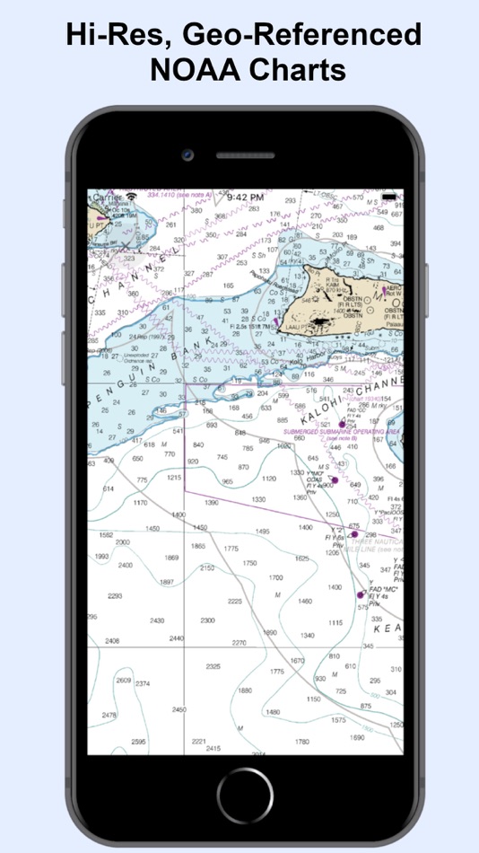
* 1000+ NOAA Raster Navigational Charts (RNC) available for download and for offline use. RNC are high resolution, full-color, geo-referenced, digital images of NOAA paper nautical charts.
* 1000+ NOAA Navigational Charts for online use that includes GPS location, navigation plotting and more.
* Basic instrumentation - GPS location, Longitude, Latitude and Device Compass.
* Assitance Support - Link to Navigation Center, Radio Information.for Boaters.
Additional information about the charts and data provided with this app:
NOAA RNC® charts are full-color, geo-referenced, digital images of NOAA paper nautical charts.
RNCs can be used with global positioning system (GPS) enabled electronic chart systems or other “chart plotter” display systems to provide real-time vessel positioning.
NOAA RNCs comply with the International Hydrographic Organization RNC Product Specification.
RNCs are approved for use by IMO ECDIS mandated vessels only if adequate ENC data is not available. Since complete ENC coverage is available in all U.S. waters, vessels required to use ECDIS may not navigate with NOAA RNCs.
NOAA RNCs DO NOT meet USCG chart carriage requirements for commercial vessels.
NOAA RNCs may be downloaded free from the NOAA chart locator or the NOAA nautical chart catalog.
----------
Electronic Navigational Charts (ENC) are vector data sets that support all types of marine navigation. Originally designed for large commercial vessels using a sophisticated navigational computer called an Electronic Chart Display and Information System (ECDIS), ENCs are now also being used on simpler electronic chart systems and “chart plotters” on many types of ships and by recreational boaters. NOAA ENCs help provide real-time ship positioning, as well as collision and grounding avoidance.
NOAA ENCs comply with the International Hydrographic Organization ENC Product Specification. ENCs are produced around the world by many different countries’ national hydrographic or charting agencies. NOAA maintains more than 1,000 NOAA ENC® datasets over U.S. coastal waters and the Great Lakes. The U.S. Army Corps of Engineers produces a similar product, called Inland ENC (IENC) for many U.S. rivers.
Screenshot


Novità
- Versione: 1.2
- Aggiornata:
- RNC Viewer integration for online Charts
Prezzo
- Oggi: $5.99
- Minimo: Gratis
- Massimo: $5.99
Monitora prezzi
Sviluppatore
- Amni LLC
- Piattaforme: iOS App (9)
- Listes: 0 + 0
- Punti: 2 + 29 ¡
- Classificazioni: 0
- Recensioni: 0
- Sconti: 0
- Video: 0
- RSS: Sottoscrivi
Punti
Non trovato ☹️
Classificazioni
Non trovato ☹️
Listes
Non trovato ☹️
Recensioni
Scrivi tu la prima recensione!
Informazioni aggiuntive
- Categoria:
iOS App›Navigazione - Sistemi operativi:
iPad,iPhone,iOS 13.0 e versioni successive - Dimensioni:
894 Kb - Lingue supportate:
English - Classificazione contenuti:
4+ - App Store Voto:
3.8(13) - Aggiornata:
- Data di uscita:
Contatti
- Sito web:
 http://www.grkov.com
Ti potrebbero piacere anche
-
- Nautical Charts & Maps
- iOS App: Navigazione di: LW Brands, LLC
- $8.99
- Listes: 0 + 0 Classificazioni: 0 Recensioni: 0
- Punti: 0 + 3,495 Versione: 1.12 Main Features Include: + NOAA Electronic Navigational Charts (ENC) + NOAA Weather Map Overlays -- ELECTRONIC NAVIGATION CHARTS -- Electronic Navigational Charts (ENC) are vector data ...
-
- Texas – Raster Nautical Charts
- iOS App: Navigazione di: Vishwam B
- $2.99
- Listes: 0 + 0 Classificazioni: 0 Recensioni: 0
- Punti: 0 + 1 Versione: 3.5 THE ALL NEW ADVANCED MARINE RASTER NAUTICAL CHARTS APP FOR BOATERS AND SAILORS! THIS MAP PROVIDES ALL THE NECESSARY TOOLS FOR EASY NAVIGATION ON WATER. CONTINUOUS CHARTS DISPLAY MAKES ...
-
- Marine Navigation - Lake Depth Maps - USA - Offline Gps Nautical Charts for Fishing, Sailing and Boating
- iOS App: Navigazione di: Bist LLC
- $22.99
- Listes: 0 + 0 Classificazioni: 0 Recensioni: 0
- Punti: 0 + 16 Versione: 58.0.0 Marine Navigation App offers access to NOAA marine vector charts, freshwater lake maps, USACE inland river maps. Only marine GPS app to have route assistance with Voice Prompts for ...
-
- Florida Nautical Charts GPS HD
- iOS App: Navigazione di: Flytomap
- $9.99
- Listes: 0 + 0 Classificazioni: 0 Recensioni: 0
- Punti: 0 + 9 Versione: 5.9.2 Flytomap is a valid and interesting alternative, Benetti Yachts Featured in : On the Deck Florida, Bahamas and North Cuba coverage resident in the app. It works WITHOUT mobile ...
-
- Memory-Map for All
- iOS App: Navigazione di: Memory-Map
- Gratis
- Listes: 0 + 0 Classificazioni: 0 Recensioni: 0
- Punti: 0 + 5 Versione: 1.3.1 Download maps for Offline GPS Navigation. No mobile data connection required. Your favorite maps and charts from OS, Hema, NOAA, and many more. Fully customizable map, data display and
-
- iSailGPS : NOAA USA RNC Charts
- iOS App: Navigazione di: James Associates Inc.
- $7.99
- Listes: 0 + 0 Classificazioni: 0 Recensioni: 0
- Punti: 0 + 63 Versione: 9.4.5 Unleash the navigation potential of your iPhone or iPad with SailGPS! Turn your device into a high-performance GPS receiver with USA NOAA Raster Nautical Charts, even without a cell ...
-
- Aqua Map Boating
- iOS App: Navigazione di: GEC s.r.l.
- * Gratis
- Listes: 0 + 0 Classificazioni: 0 Recensioni: 0
- Punti: 0 + 9,800 Versione: 40.1 Free 14-day trial available for all subscriptions Get the latest charts you can use offline, weather, tides and POIs from ActiveCaptain and Waterway Guide. Connect AIS and your boat ...
-
- Hip Charts
- iOS App: Navigazione di: Walk About Apps
- Gratis
- Listes: 0 + 0 Classificazioni: 0 Recensioni: 0
- Punti: 0 + 2 Versione: 2.1 Hip Charts brings NOAA ENC nautical charts to your fingertips... for FREE! NOAA charts automatically load as you move the map and can be downloaded via cellular or WiFi connections. ...
-
- mKart Marine Navigation
- iOS App: Navigazione di: GEOPHONE GROUP INTERNATIONAL Oy
- Gratis
- Listes: 0 + 0 Classificazioni: 0 Recensioni: 0
- Punti: 1 + 3 Versione: 1.8.727 mKart 3D marine App is for safe and comfortable navigation. Product Highlights: WEB CONSOLE: E-shop; ENCs and cartographic products Catalogue; Portfolio optimization; Fleet management;
-
- Marine Navigation
- iOS App: Navigazione di: Marco Palaferri
- $7.99
- Listes: 0 + 0 Classificazioni: 0 Recensioni: 0
- Punti: 0 + 1 Versione: 9.3.1 MARINE NAVIGATION Find your way on the sea with ease! Our GPS chartplotter for boating is an easy-to-use offline GPS tracker and route planner featuring worldwide offline maps. Whether