| 개발자: | Ture Apps AS (2) | ||
| 가격: | * 무료 | ||
| 순위: | 0 | ||
| 리뷰: | 0 리뷰 작성 | ||
| 목록: | 0 + 0 | ||
| 포인트: | 0 + 6 (3.7) ¡ | ||
| App Store | |||
기술
")
- Register, measure and categorise -
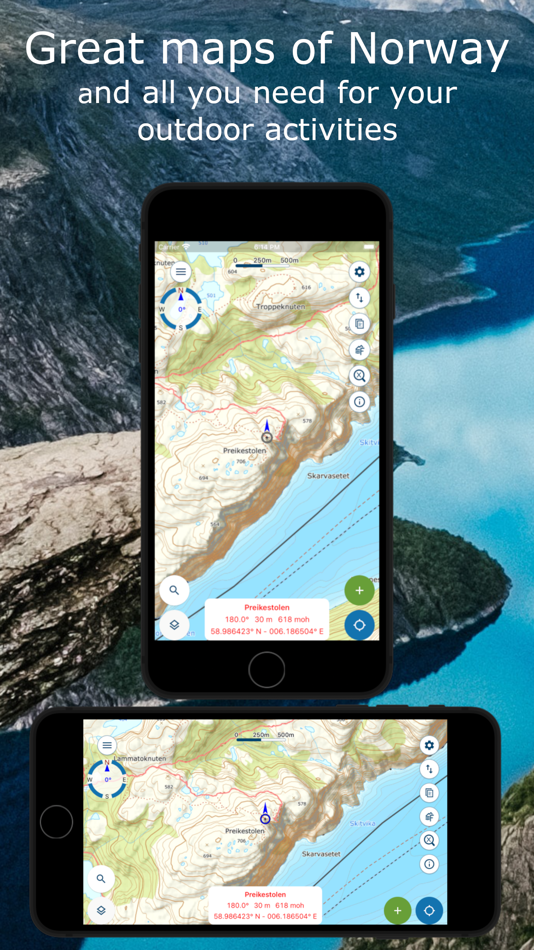
Register points of interest, routes, areas and record tracks. Organize the data by creating your own categories with colours and styles/icons for each category. If desired, your data can be written and read to/from GPX files or synchronised across devices and the map portal norgeskart.avinet.no. You can also easily share files with others from the lists of data in the app.
- More than 40 maps and map layers -
Beautiful topographical and ortophoto maps can be downloaded before you go on a trip. Combine with as many layers as you wish to create a complete overview of your surroundings. E.g. by turning on Pistes, Avalanche steepness and Weak ice layers.
Norgeskart friluftsliv differs from most other map apps in that it supports both Mercator and UTM projected maps. This let it display the high-resolution UTM versions of the topographic maps of the Norwegian Mapping Authority. The UTM service has 2 extra levels of details compared to the Mercator version.
- Own map and map layers -
Are you missing a map or map layer? Add your own maps and layers from WMS, WMTS, XYZ and TMS services. A great source for additional maps and layers in Norway is the site geonorge.no. You can also try adding maps from other countries, but the app only support Mercator and UTM 33 projections.
- TellTur -
Plan your next trip with trip suggestions and descriptions from telltur.no. With TellTur you can use the app to register when you arrive at a tour destination and compete with others to visit the most places.
The app has both free and paid content. By subscribing you support my development of the app and take full advantage of all the exciting things it has to offer.
Free content:
------------------
- Mercator topographical and nautical maps for Norway, Svalbard and Jan Mayen
- Open air routes summer and winter
- Place name and heigh/depth for cursor position
- Search for place names, addresses or coordinates
- Import and export of GPX files
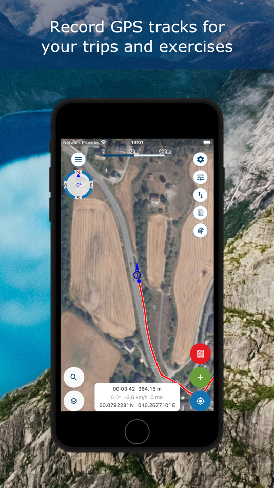
- Track recording with diagrams and details
- Create routes and POIs
- Compass
- Property borders
Pro subscription (99 NOK a year):
------------------
- Download Norwegian maps for offline use
- Extra detailed UTM versions of topographical maps.
- Create and measure areas
- Create own categories .
- Topo map for Sweden (offline, but no download function)
- Upload POIs, tracks and routes
- Synchronize data across devices and with map portal
- Economic (N5 raster) map
- Historical map
- Mountain bike routes
- Pistes for Alpine and Cross-country
- Avalanche awareness, steepness and incidents
- Weak ice
- Snow depth and skiing conditions
- Snowmobile tracks
- Sea depths and lake depths
- Conservation areas
- Clay and radon
Pro+ subscription (199 NOK a year):
------------------
- All in Pro
- Ortophoto maps for Norway and Svalbard
- Add your own maps and layers
- Periodic update of points from online KML files. Tested with TeleSpor.
The following applies to the auto-renewable subscriptions:
- Payment will be charged to iTunes Account at confirmation of purchase
- Subscription automatically renews unless auto-renew is turned off at least 24-hours before the end of the current period
- Account will be charged for renewal within 24-hours prior to the end of the current period, and identify the cost of the renewal
- Subscriptions may be managed by the user and auto-renewal may be turned off by going to the user's Account Settings after purchase
- Any unused portion of a free trial period, if offered, will be forfeited when the user purchases a subscription to that publication, where applicable
Terms of use: https://ture.no/en/terms-of-use-norgeskart-outdoors/
Privacy policy: https://ture.no/en/privacy-policy-norgeskart-outdoors/
스크린샷


새로운 기능
- 버전: 1.10.2
- 업데이트:
- - Fixed combined map of Sweden and Norway that still was not working for all users.
- Fixed "Smooth and simplify" function for tracks.
- Minor improvements and fixes.
가격
-
* 인앱 구매 - 오늘: 무료
- 최소: 무료
- 최대: 무료
가격 추적
개발자
- Ture Apps AS
- 플랫폼: Android 앱 (1) iOS 앱 (1)
- 목록: 0 + 0
- 포인트: 1 + 6 ¡
- 순위: 0
- 리뷰: 0
- 할인: 0
- 동영상: 0
- RSS: 구독
포인트
0 ☹️
순위
0 ☹️
목록
0 ☹️
리뷰
첫 번째 리뷰를 남겨보세요 🌟
추가 정보
주소록
- 웹사이트:
 https://ture.no/
당신은 또한 같은 수 있습니다
-
- Norgeskart
- iOS 앱: 내비게이션 게시자: Norgeskart AS
- * 무료
- 목록: 0 + 0 순위: 0 리뷰: 0
- 포인트: 1 + 39 (4.7) 버전: 4.81.0 The map of Norway app for iPhone and iPad is the most detailed map of Norway. Map of Norway app is suitable for both hikers, tourists and city walkers. Comprehensive, accurate maps of ... ⥯
-
- Feltregistrering
- iOS 앱: 비즈니스 게시자: Asplan Viak Internet AS
- 무료
- 목록: 0 + 0 순위: 0 리뷰: 0
- 포인트: 0 + 0 버전: 2025.1 Feltregistrering allows you to collect information in field regardless of mobile coverage. Maps, map layers and forms are defined on the web by the client's administrator and are made ... ⥯
-
- Wild Guide Scandinavia
- iOS 앱: 여행 게시자: Wild Things Publishing Ltd
- $3.99
- 목록: 0 + 0 순위: 0 리뷰: 0
- 포인트: 0 + 0 버전: 4.15.0 Wild Guide Scandinavia - Norway, Sweden, Iceland and Denmark The best-selling Wild Guide series travels to Norway, Sweden, Iceland and Denmark to explore its incredible hidden places. ... ⥯
- 새로운
- Outdoor Facilities in Denmark
- iOS 앱: 여행 게시자: Bo Kalvslund
- $1.99
- 목록: 0 + 0 순위: 0 리뷰: 0
- 포인트: 0 + 0 버전: 1.0 Discover Denmark's nature with Friluftsliv - your comprehensive guide to over 15 different types of outdoor facilities across the country. FEATURES: Interactive map with all outdoor ... ⥯