| Разработчик: | JOMO Solutions Ltd (18) | ||
| Цена: | $1.99 | ||
| Рейтинги: | 0 | ||
| Отзывы: | 0 Написать отзыв | ||
| Списки: | 0 + 0 | ||
| Очки: | 0 + 1 ¡ | ||
| Очки + 1 | |||
Описание
")
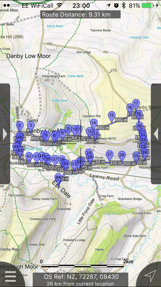
Beautifully detailed maps supplied by Ordnance Survey.
North York Moors Maps provides a useful offline mapping reference and navigation aid whilst travelling throughout the North York Moors by footpath, road, rail, canal, lake and river. Intuitive route and waypoint management features are implemented enabling creation, modification, deletion, import and export of routes. A powerful offline search facility can locate places, roads, post codes and hills within the region. Worldwide online Apple maps (Standard, Satellite and Hybrid). Map features that you are used to with Apple maps are available on both offline and online maps as well as providing 3D buildings on Apple maps (where available).
Maps
7 different levels of offline 2014/5 Ordnance Survey map detail from national overview to street view within the region. (No data connection required)
Progressively more detailed maps are automatically loaded as the map view is zoomed. The OS recommended viewing scales for the more detailed maps are approximately as follows:
1:1000,000 (Whole of GB is covered)
1:250,000
1:50,000
1:25,000
1:10,000 ( Roads/streets are labelled)
The map region of the more detailed maps covers a rectangular region around the national park boundary (ref. http://jomosolutions.com/Maps)
- Contours with height information and annotated height points.
- Extensive footpaths from ©OpenStreetMap contributors
- National Park boundary demarkation
App
- Route/Waypoint management
- Offline search functionality with searchable locations (places, roads, post codes and hills). (For the place search a location's latitude and longitude is accurate to 0.1 of a minute of the centre point of the 1x1 km National Grid square in which the name falls)
- Detailed hill information, including height, OS Grid Ref, latitude and longitude, region, parent, classification, drop and hill specific links to Streetmap, Geograph and Hill Bagging web sites
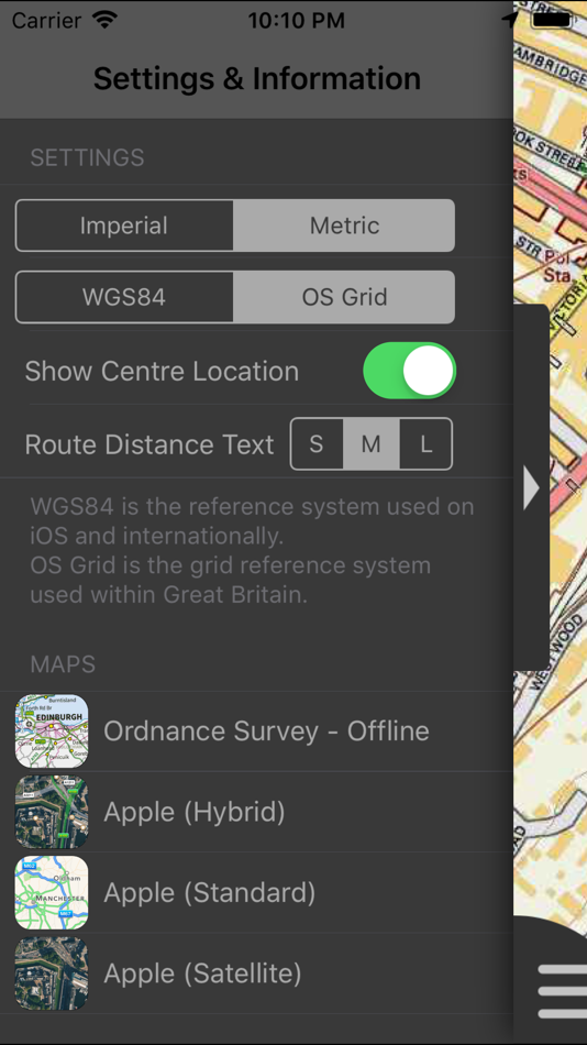
- Display of current GPS position as OS Grid Reference or WGS84 latitude and longitude
- "Share My Location" allowing users to share an image of their current location and location references. Buttons are provided to share location information by Facebook, Twitter, iMessage/SMS and e-mail
- Online access to worldwide Apple Standard, Satellite and Hybrid maps
- Apple 3D Buildings are displayed on Apple Standard maps
- Apple maps contain Points of Interest
- User location can be tracked with or without heading on all online and offline maps (GPS capable devices only)
- Display of scale bar in either metric or imperial units
- Display of current speed
- Zoom, pan, rotation of all maps
- Pitch of Apple Standard and Ordnance Survey maps
- Selection of current location annotation for display of speed and location data
- User setting for speed display in Miles per Hour (mph) or Kilometres per Hour (kph)
- Selection of search result pin annotations to display location information
- Collective deletion of search result annotation pins
- A user guide is provided within the app information
The OS search data was published by Ordnance Survey in 2014.
Extracts from "The Database of British and Irish Hills" v14 published 22/04/2014 (ref. http://www.hills-database.co.uk/index.html )
No warranty
The data is supplied by Apple, Ordnance Survey, contributors to OpenStreetMap and Database of British and Irish Hills.
The Information is licensed 'as is' and the Information Provider and/or Licensor excludes all representations, warranties, obligations and liabilities in relation to the Information to the maximum extent permitted by law.
The Information Provider and/or Licensor are not liable for any errors or omissions in the Information and shall not be liable for any loss, injury or damage of any kind caused by its use.
This app is not a substitute for a paper map and compass.
Скриншоты


Что нового
- Версия: 2.1.1
- Обновлено:
- Fixed intermittent failures within the search functionality.
If you like the app please leave an app review.
Цена
- Сегодня: $1.99
- Минимум: $1.99
- Максимум: $1.99
Отслеживайте цены
Разработчик
- JOMO Solutions Ltd
- Платформы: iOS Приложения (18)
- Списки: 0 + 0
- Очки: 0 + 17 ¡
- Рейтинги: 0
- Отзывы: 0
- Скидки: 0
- Видео: 0
- RSS: Подписаться
Очки
Не найдено ☹️
Рейтинги
Не найдено ☹️
Списки
Не найдено ☹️
Отзывы
Ваш отзыв будет первым!
Дополнительная информация
- Категория:
iOS Приложения›Навигация - Операционные системы:
Apple Watch,iPad,iPhone,iOS 8.0 и выше - Размер:
344 Mb - Поддерживаемые языки:
English - Возрастные ограничения:
4+ - App Store Рейтинг:
5.0(1) - Обновлено:
- Дата выпуска:
Контакты
Вам также могут понравиться
-
- York U Maps
- iOS Приложения: Навигация От: YAN CHEN
- Бесплатно
- Списки: 1 + 0 Рейтинги: 0 Отзывы: 0
- Очки: 1 + 3 Версия: 2.0 York U Maps is a navigation app for Keele campus of York University. You can search for buildings with their abbreviations, e.g. LAS for Lassonde Building, which are commonly used in ...
-
- 4WD Maps - Offline Topo Maps
- iOS Приложения: Навигация От: Hema Maps
- $64.99
- Списки: 0 + 0 Рейтинги: 0 Отзывы: 0
- Очки: 0 + 4 Версия: 2.4.2 Best value Hema App. The one-time cost includes all Hema 4WD maps, without any recurring subscriptions. Use offline mapping and your device s in-built GPS receiver to see where you are
-
- Avenza Maps: Offline Mapping
- iOS Приложения: Навигация От: Avenza Systems Inc.
- * Бесплатно
- Списки: 0 + 0 Рейтинги: 0 Отзывы: 0
- Очки: 0 + 109,429 Версия: 5.2.1 Avenza Maps, #1 app for hiking, biking and all trails. Featuring maps from National Geographic, national parks and more! On your next adventure, stay on track with GPS using offline ...
-
- 3D Maps:Offline map GPS tracks
- iOS Приложения: Навигация От: SERGEY BEZDENEZHNYKH
- * Бесплатно
- Списки: 0 + 0 Рейтинги: 0 Отзывы: 0
- Очки: 0 + 88 Версия: 2.4.7 New engine from MapBox with 3D maps. Create, import, export tracks with waypoints. Supports offline maps. Has several 2D map styles - satellite, streets, combo and dark. Two 3D map ...
-
- Maps 3D PRO - Hike & Bike
- iOS Приложения: Навигация От: movingworld GmbH
- * $3.99
- Списки: 1 + 4 Рейтинги: 0 Отзывы: 0
- Очки: 0 + 194 Версия: 6.8 Enjoy exploring the great outdoors? If you re a fan of biking, hiking and running then Maps 3D is the ideal app designed for planning your outdoor adventures. Whereas other mapping ...
-
- Offline Map Navigation
- iOS Приложения: Навигация От: VirtualMaze
- Бесплатно
- Списки: 0 + 0 Рейтинги: 0 Отзывы: 0
- Очки: 0 + 258 Версия: 5.0.6 Search, Get Directions & Navigate anywhere even without internet connection Turn-by-turn route instructions & real-time navigation Find directions for car, motorbike, bicycle or walk ...
-
- Offline Maps Nav by Karta GPS
- iOS Приложения: Навигация От: Karta
- * Бесплатно
- Списки: 0 + 0 Рейтинги: 0 Отзывы: 0
- Очки: 0 + 3 Версия: 2.46.06 Navigate in Germany and download any map from all over the world! This special German version offers free traffic and Speed Radars information with lifetime updates. All maps are free ...
-
- Offline Guide: Cedar Point
- iOS Приложения: Навигация От: Advantage Inc.
- Бесплатно
- Списки: 0 + 0 Рейтинги: 0 Отзывы: 0
- Очки: 0 + 1,075 Версия: 1.2 Maximize your Cedar Point experience with The Unofficial Universal Cedar Point App! Find information on rides, dining options, aqua rides, shows, and more for Cedar Point and Soak City
-
- North Dakota Road Conditions
- iOS Приложения: Навигация От: LW Brands, LLC
- Бесплатно
- Списки: 0 + 0 Рейтинги: 0 Отзывы: 0
- Очки: 0 + 11 Версия: 1.0 The best way to view North Dakota 511 CCTV traffic cameras. MAIN FEATURES INCLUDE: - Create custom camera groups - Quickly view all cameras on your route - Add camera widgets to your ...
-
- Goose Maps for Watch
- iOS Приложения: Навигация От: GOOSE MAPS LTD
- Бесплатно
- Списки: 0 + 0 Рейтинги: 0 Отзывы: 0
- Очки: 0 + 181 Версия: 1.3 Features - Navigate easily everywhere Our pedestrian and bike navigation perfectly work even if your iPhone stayed at home. - Search objects you need Our search helps you to find ...
-
- Local Maps
- iOS Приложения: Навигация От: Local Maps Inc
- Бесплатно
- Списки: 0 + 0 Рейтинги: 0 Отзывы: 0
- Очки: 0 + 4 Версия: 1.3 Find the funnel cake stand or next horse race faster than ever before with this free and easy to use navigation platform for fairs and festivals. Start enjoying your time by finding ...
-
- Google Maps
- iOS Приложения: Навигация От: Google
- Бесплатно
- Списки: 13 + 6 Рейтинги: 5 (3) Отзывы: 5 (1)
- Очки: 5 + 5,898,641 Версия: 6.114.3 Navigate your world faster and easier with Google Maps. Over 220 countries and territories mapped and hundreds of millions of businesses and places on the map. Get real-time GPS ...
-
- Apple Maps
- iOS Приложения: Навигация От: Apple
- Бесплатно
- Списки: 3 + 1 Рейтинги: 4 (1) Отзывы: 0
- Очки: 1 + 23,006 Версия: 1.5 Maps Apple Maps is the best way to navigate and explore the world - all with your privacy protected. What s New: Multi-stop routing lets you add multiple stops along your driving route
-
- Mapy.cz: maps & navigation
- iOS Приложения: Навигация От: Seznam.cz a.s.
- Бесплатно
- Списки: 0 + 0 Рейтинги: 0 Отзывы: 0
- Очки: 2 + 631 Версия: 6.40.1 PLAN YOUR ROUTE - hiking and cycling trails - cross-country skiing and ski-alpine trails - unique travel tips feature plans a trip through the most interesting places in the area - ...