| ผู้พัฒนา: | MapGears inc. (28) | ||
| ราคา: | ฟรี | ||
| การจัดอันดับ: | 0 | ||
| ความเห็น: | 0 เขียนความเห็น | ||
| รายการ: | 0 + 0 | ||
| แต้มแล: | 0 + 292 (4.7) ¡ | ||
| App Store | |||
คำอธิบาย
")
**NEW THIS SEASON**
► Track your trips: leave breadcrumbs for easier backtracking, get statistics on your average speed and distance traveled, and much more!
► List your equipment: keep track of how much distance you covered with a specific vehicle and keep notes on each one.
► Satellite View: enjoy the mobile app with a better basemap and add the Satellite View in your tools!
*****
The New York State Snowmobile Association(NYSSA) brings an enhanced version of its web application to your pockets, making for a better riding experience than ever. Working both with and WITHOUT mobile data coverage, you will be able to enjoy the app’s functionalities no matter where you are on the trails.
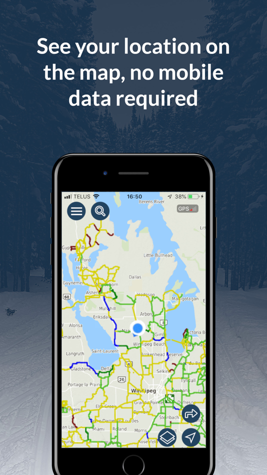
This app gives you access to the following *OFFLINE* features, anywhere, anytime, even in areas without cell coverage:
► See your location on the map through your phone’s GPS signal
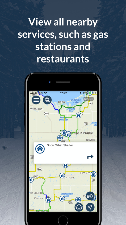
► View nearby restaurants, gas stations, hotels, parking, and other services
► Access the trail conditions as per the last data connection available
► See the distance between you and a specific point
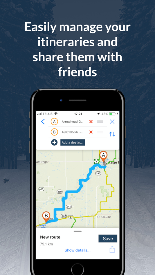
► Quickly save and load itineraries
Getting back to a zone with mobile coverage? Enjoy these additional *ONLINE* features :
► Keep an eye on updated trail statuses for the best riding experience
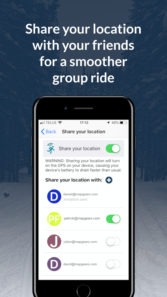
► Easily meet with friends by sharing your position with each other (no one else can see your location)
► Plan out an itinerary and share it with your group
Welcome to the NYSSA mobile experience and enjoy the ride!
Notes:
►Continued use of the GPS and location sharing running in the background can significantly increase battery consumption. It is recommended to toggle it off when not needed to improve autonomy.
The Pro Version is a 4.99$ USD per year auto-renewable subscription. Payment will be charged to the iTunes Account at confirmation of purchase. Auto-renewal may be turned off by going to the user’s account settings after purchase. Subscription automatically renews unless auto-renew is turned off at least 24 hours before the end of the current period. The account will be charged for renewal within 24 hours before the end of the current period, and identify the renewal cost. Subscriptions may be managed by the user and auto-renewal may be turned off by going to the user’s Account Settings after purchase.
Link to our privacy policy: https://www.evtrails.com/privacy-terms-and-conditions/
Link to our terms of use: https://www.evtrails.com/terms-and-conditions/
ภาพหน้าจอ
ราคา
- วันนี้: ฟรี
- ต่ำสุด: ฟรี
- มากที่สุด: ฟรี
ติดตามราคา
ผู้พัฒนา
- MapGears inc.
- แพลตฟอร์ม: iOS แอป (28)
- รายการ: 0 + 0
- แต้มแล: 4 + 523 ¡
- การจัดอันดับ: 0
- ความเห็น: 0
- ลดราคา: 0
- วิดีโอ: 0
- RSS: ติดตาม
แต้มแล
0 ☹️
การจัดอันดับ
0 ☹️
รายการ
0 ☹️
ความเห็น
แสดงรีวิวเป็นคนแรกเลย 🌟
ข้อมูลเพิ่มเติม
รายชื่อติดต่อ
- เว็บไซท์:
 https://nyssa.evtrails.com
คุณอาจชอบ
-
- Sask Snowmobile Trails
- iOS แอป: การนำทาง โดย: MapGears inc.
- * ฟรี
- รายการ: 0 + 0 การจัดอันดับ: 0 ความเห็น: 0
- แต้มแล: 0 + 0 เวอร์ชัน: 4.0.6 Out exploring on your snowmobile? Take your own mobile trail assistant for the ride! **NEW THIS SEASON** Track your trips: leave breadcrumbs for easier backtracking, get statistics on ... ⥯
-
- Trails Offroad: Offline Maps
- iOS แอป: การนำทาง โดย: TRAILS OFFROAD LLC
- ฟรี
- รายการ: 0 + 0 การจัดอันดับ: 0 ความเห็น: 0
- แต้มแล: 2 + 521 (4.7) เวอร์ชัน: 3.6.0 Explore with Confidence. Go Beyond the Pavement. Trails Offroad is the #1 app for discovering, planning, and navigating off-road adventures whether you're behind the wheel of a Jeep, ... ⥯
-
- Bay Ridge Trails
- iOS แอป: การนำทาง โดย: Bay Ridge Civic Association
- ฟรี
- รายการ: 0 + 0 การจัดอันดับ: 0 ความเห็น: 0
- แต้มแล: 0 + 5 (3.6) เวอร์ชัน: 1.1.1 The Bay Ridge Trails App is a hiking trail app that uses GPS to map out Bay Ridge trails. Users can use the app to find the trails and navigate around Bay Ridge. The app provides a ... ⥯
-
- As-Salt Walking Trails
- iOS แอป: การนำทาง โดย: Llama Digital
- ฟรี
- รายการ: 0 + 0 การจัดอันดับ: 0 ความเห็น: 0
- แต้มแล: 0 + 0 เวอร์ชัน: 1.0 Soak in the beauty of As-Salt and experience this magical town by taking a walking trail. These self-guided trails will give you an authentic experience of life in the town, and take ... ⥯
-
- Wikiloc - Trails of the World
- iOS แอป: การนำทาง โดย: Wikiloc Outdoor SL
- ฟรี
- รายการ: 0 + 0 การจัดอันดับ: 0 ความเห็น: 0
- แต้มแล: 0 + 4,873 (4.8) เวอร์ชัน: 3.25.6 Discover millions of outdoor trails around the world. Choose between hiking, running, bike, MTB, kayak, ski or up to 80 different types of activities. Record your own routes on a map, ... ⥯
-
- Park City Trails
- iOS แอป: การนำทาง โดย: ECO Systems
- ฟรี
- รายการ: 0 + 0 การจัดอันดับ: 0 ความเห็น: 0
- แต้มแล: 0 + 0 เวอร์ชัน: 2024.9.8 Park City Trails allows you to see all of the summer and winter trails available in Park City (no more need of multiple apps). You can explore and discover trails, whether you have ... ⥯
-
- Topographic Maps & Trails
- iOS แอป: การนำทาง โดย: LW Brands, LLC
- $4.99
- รายการ: 1 + 0 การจัดอันดับ: 0 ความเห็น: 0
- แต้มแล: 1 + 2,767 (4.6) เวอร์ชัน: 1.6 DOWNLOAD ALL MAPS FOR OFFLINE USE MAIN FEATURES INCLUDE: - USGS Topographic Maps - Satellite + Topo Maps - Hiking Tracker USGS TOPO MAP USGS Topo is a tile cache base map service that ... ⥯
-
- GNodeTo: Toronto Trails Map
- iOS แอป: การนำทาง โดย: QI.AI Inc
- ฟรี
- รายการ: 0 + 0 การจัดอันดับ: 0 ความเห็น: 0
- แต้มแล: 5 + 0 เวอร์ชัน: v1.1.13 GnodeTo is your go-to app for planning and tracking biking or hiking trips in the Great Toronto Area (GTA). Whether you're an experienced adventurer or just starting out, GnodeTo makes ⥯
-
- Bread Crumbs Trails
- iOS แอป: การนำทาง โดย: YOURFULLSTACK, LLC
- $1.99
- รายการ: 0 + 0 การจัดอันดับ: 0 ความเห็น: 0
- แต้มแล: 3 + 3 (4.7) เวอร์ชัน: 2.3.3 Bread Crumbs Trail is a location pinging app. All location data is stored within the app and stored on your local device. App is designed for educational research, fun, recreation, ... ⥯
-
- OnPoint Trails: OHV Trail Map
- iOS แอป: การนำทาง โดย: Brenda Leon
- * ฟรี
- รายการ: 0 + 0 การจัดอันดับ: 0 ความเห็น: 0
- แต้มแล: 0 + 12 (4.7) เวอร์ชัน: 1.3 OnPoint Trails: Your Ultimate Offline Off-Road Navigator Discover the freedom of off-roading with OnPoint Trails, the all-in-one app designed for adventurers who seek to explore CA OHV ⥯
-
- TrailAware: Bike & Hike Trails
- iOS แอป: การนำทาง โดย: TrailAware, Inc.
- ฟรี
- รายการ: 0 + 0 การจัดอันดับ: 0 ความเห็น: 0
- แต้มแล: 0 + 31 (5.0) เวอร์ชัน: 2.6 Experience a groundbreaking way to discover and view all types of trails with TrailAware. Powered by our patented dynamic geospatial mapping technology, TrailAware provides the ... ⥯
-
- Bell Mountain Ranch Trails
- iOS แอป: การนำทาง โดย: Sean Molloy
- ฟรี
- รายการ: 0 + 0 การจัดอันดับ: 0 ความเห็น: 0
- แต้มแล: 0 + 3 (4.7) เวอร์ชัน: 1.51 The BMR Trails app helps users of the BMR trail system to navigate the trails with ease. Your current location is shown on a satellite map of the trail system, with every trail marked ... ⥯
-
- Collie Wambenger Trails
- iOS แอป: การนำทาง โดย: Government of Western Australia - Department of Parks and Wildlife
- ฟรี
- รายการ: 0 + 0 การจัดอันดับ: 0 ความเห็น: 0
- แต้มแล: 0 + 0 เวอร์ชัน: 9.0.376 Located in South West Western Australia, Wambenger Trails offer mountain biking, walking and paddling trails, camping and water sports. This app is your go to guide for discovering all ⥯
-
- TrailPass: All Trails GPS Gaia
- iOS แอป: การนำทาง โดย: Polus Apps
- ฟรี
- รายการ: 0 + 0 การจัดอันดับ: 0 ความเห็น: 0
- แต้มแล: 0 + 6 (5.0) เวอร์ชัน: 1.5.0 Are you an outdoor enthusiast looking for your next adventure? Do you enjoy exploring new trails for walking, hiking, or cycling? Look no further than TrailPass, the ultimate mobile ... ⥯