| Nhà phát triển: | Ash Point Ltd. (11) | ||
| Giá bán: | Miễn phí | ||
| Xếp hạng: | 0 | ||
| Đánh giá: | 0 Viết đánh giá | ||
| Danh sách: | 0 + 0 | ||
| Điểm: | 1 + 10 (4.3) ¡ | ||
| App Store | |||
Mô tả
")
*OilTrails requires a subscription, but new subscriptions come with a 1 month, no obligation, free trial.
Supported States:
Texas
Alabama
Alaska
California
Colorado
Kansas
Louisiana
New Mexico
North Dakota
Oklahoma
Pennsylvania
Utah
Wyoming
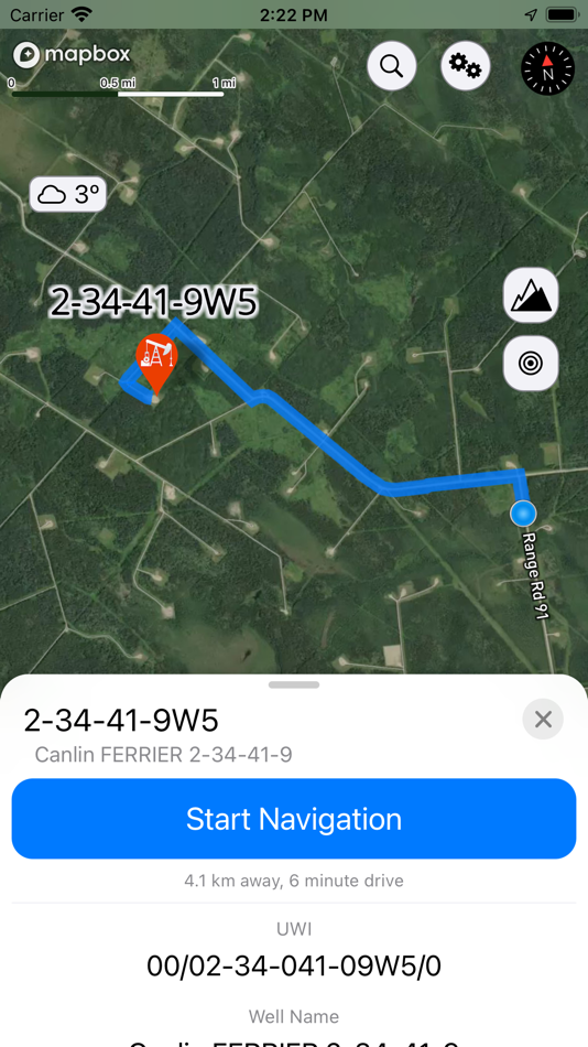
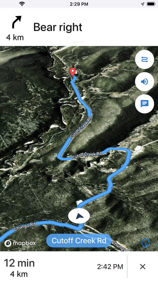
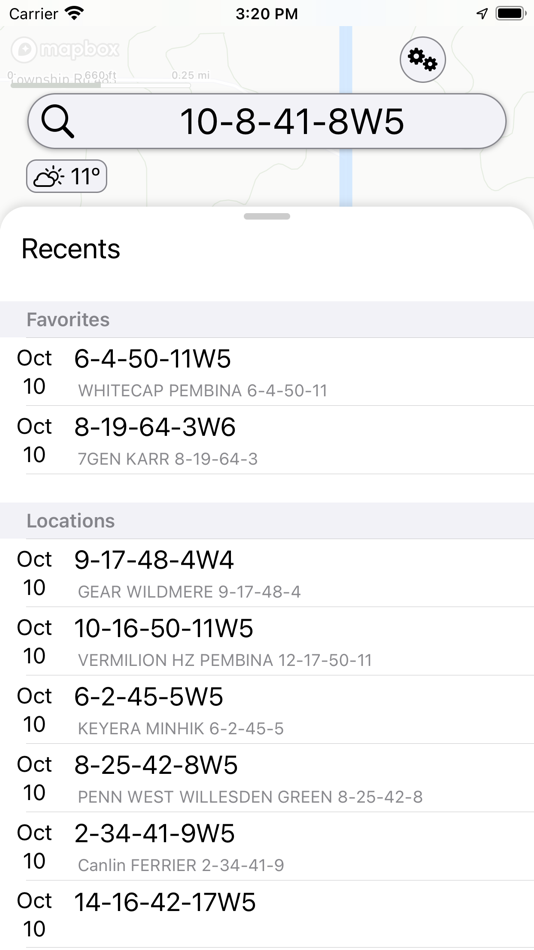
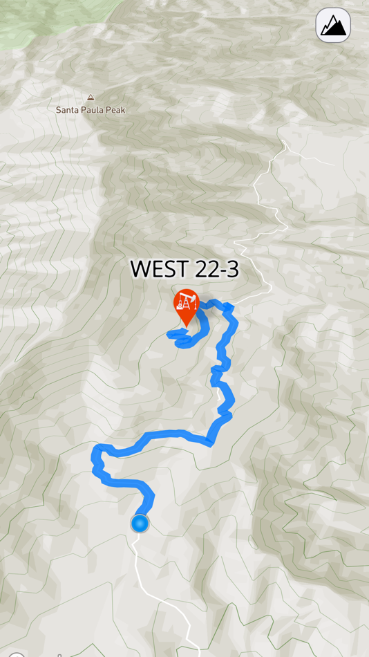
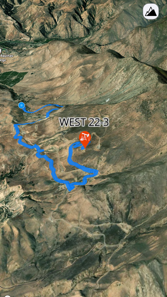
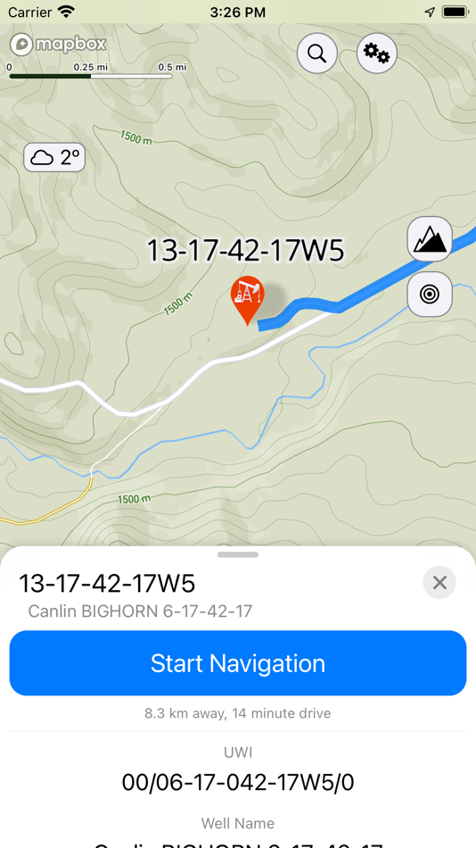
This multifunctional lease locator app makes getting to work in the oilfield a breeze. Simply enter the legal land description, name, or API number to view the surface location OR drop a pin on the map to view location and well info (if vertical). The location can be navigated to in-app, or opened in Apple or Google maps for turn by turn navigation. Change the origin location to see step-by-step directions to location from the nearest town, useful for putting together ERPs or providing visitors directions.
No cell service? No problem. As long as turn by turn navigation is started before service is lost, the directions will continue to function so you don't have to worry about being stranded halfway to location.
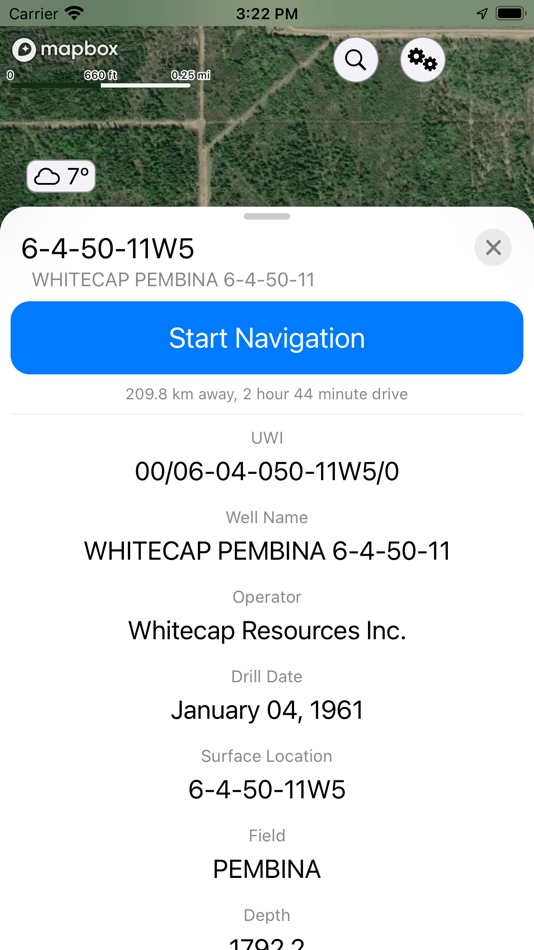
Enter a location and view well information such as the operating company, depth, drill date, current status, downhole fluid, formation, and more. Data varies depending on the region.
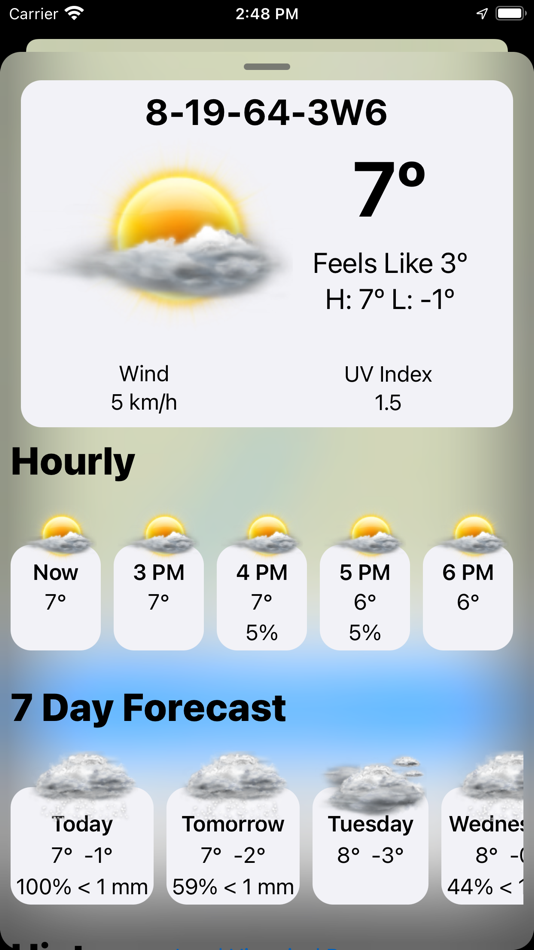
See the current, future AND past weather specific to the location entered. Wondering if the lease is too wet or has snow to be cleared? View the precipitation the location was forecasted to receive in the past three days. Scroll for 48 hrs of hourly forecasts, 7 daily forecasts, and previous forecasts.
Maps can be shown in a variety of ways including Topographical, 3D Satellite, 2D Satellite, Dark Roads, and Light Roads.
Drop a pin on the map to see the latitude and longitude of locations.
View history of past locations viewed and date they were looked up. Makes driving logs and reports a breeze by knowing where and when you were. iCloud support syncs history between compatible devices and creates a backup.
-Turn by turn GPS navigation in-app, or use Apple or Google Maps
-Enter downhole location to view well info such as the operating company, depth, drill date, current status, -downhole fluid
-View the current weather at location as well as hourly and daily forecast AND previous forecasts to see if the location has received rain/snow is the past three days
-See location in app and view with standard, hybrid, or satellite imagery
-Store history of previously viewed wells/locations
-Share location and well info via message
-Drop pins on the map to see that location's coordinates
-International support, find wells in the United States, Canada, and Australia
*Google Maps app must be installed separately to open up locations with it
*Available well information varies by region
*Previous weather is based on previous forecasts, not what the location actually received
*The available options to look up locations varies by region
Notice: Requires an in-app subscription to be purchased. 1 month free trial to new users. Subscriptions will auto renew until cancelled. With an active subscription or Access Pass you will receive all app features.
Terms of Use: https://www.apple.com/legal/internet-services/itunes/dev/stdeula/
Ảnh chụp màn hình
Giá bán
- Hôm nay: Miễn phí
- Tối thiểu: Miễn phí
- Tối đa: Miễn phí
Theo dõi giá
Nhà phát triển
- Ash Point Ltd.
- Nền tảng: iOS Ứng dụng (11)
- Danh sách: 0 + 0
- Điểm: 1 + 17 ¡
- Xếp hạng: 0
- Đánh giá: 0
- Giảm giá: 0
- Video: 0
- RSS: Đăng ký
Điểm
-

- 4,778 Chuchi Flores
- +1

Xếp hạng
0 ☹️
Danh sách
0 ☹️
Đánh giá
Hãy là người đầu tiên đánh giá 🌟
Thông tin bổ sung
- Phiên bản: 2.3.027
- Danh mục:
iOS Ứng dụng›Bản đồ và dẫn đường - HĐH:
iPad,iPhone,iOS 17.0 trở lên - Kích thước:
118 Mb - Ngôn ngữ được hỗ trợ:
English - Xếp hạng nội dung:
4+ - App Store Xêp hạng:
4.3(10) - Cập nhật:
- Ngày phát hành:
Danh bạ
- Trang web:
 https://oiltrails.ca/
- 🌟 Chia sẻ
- App Store
Bạn cũng có thể thích
-
- Trails Offroad: Offline Maps
- iOS Ứng dụng: Bản đồ và dẫn đường Bởi: TRAILS OFFROAD LLC
- Miễn phí
- Danh sách: 0 + 0 Xếp hạng: 0 Đánh giá: 0
- Điểm: 2 + 598 (4.7) Phiên bản: 3.6.3 Explore with Confidence. Go Beyond the Pavement. Trails Offroad is the #1 app for discovering, planning, and navigating off-road adventures whether you're behind the wheel of a Jeep, ... ⥯
-
- WV OIL AND GAS MAP
- iOS Ứng dụng: Bản đồ và dẫn đường Bởi: WV OIL AND GAS MAP, INC.
- $39.99
- Danh sách: 0 + 0 Xếp hạng: 0 Đánh giá: 0
- Điểm: 0 + 1 (5.0) Phiên bản: 1.0 Welcome to WV Oil and Gas Map your premier mobile resource for navigating the dynamic energy landscape of West Virginia! We're here to revolutionize your understanding of the state's ... ⥯
-
- Bay Ridge Trails
- iOS Ứng dụng: Bản đồ và dẫn đường Bởi: Bay Ridge Civic Association
- Miễn phí
- Danh sách: 0 + 0 Xếp hạng: 0 Đánh giá: 0
- Điểm: 0 + 5 (3.6) Phiên bản: 1.1.1 The Bay Ridge Trails App is a hiking trail app that uses GPS to map out Bay Ridge trails. Users can use the app to find the trails and navigate around Bay Ridge. The app provides a ... ⥯
-
- As-Salt Walking Trails
- iOS Ứng dụng: Bản đồ và dẫn đường Bởi: Llama Digital
- Miễn phí
- Danh sách: 0 + 0 Xếp hạng: 0 Đánh giá: 0
- Điểm: 0 + 0 Phiên bản: 1.0 Soak in the beauty of As-Salt and experience this magical town by taking a walking trail. These self-guided trails will give you an authentic experience of life in the town, and take ... ⥯
-
- DINOPAY - Sinclair Oil
- iOS Ứng dụng: Bản đồ và dẫn đường Bởi: P97 Networks, Inc.
- Miễn phí
- Danh sách: 0 + 0 Xếp hạng: 0 Đánh giá: 0
- Điểm: 0 + 38,339 (4.7) Phiên bản: 6.0.1 DINOPAY is the official iPhone app of Sinclair Oil. Locate Sinclair gas stations and truck stops and identify stations with amenities such as car washes or air/water dispensers. Use ... ⥯
-
- Wikiloc - Trails of the World
- iOS Ứng dụng: Bản đồ và dẫn đường Bởi: Wikiloc Outdoor SL
- Miễn phí
- Danh sách: 0 + 0 Xếp hạng: 0 Đánh giá: 0
- Điểm: 0 + 4,937 (4.8) Phiên bản: 3.25.10 Discover millions of outdoor trails around the world. Choose between hiking, running, bike, MTB, kayak, ski or up to 80 different types of activities. Record your own routes on a map, ... ⥯
-
- Park City Trails
- iOS Ứng dụng: Bản đồ và dẫn đường Bởi: ECO Systems
- Miễn phí
- Danh sách: 0 + 0 Xếp hạng: 0 Đánh giá: 0
- Điểm: 0 + 0 Phiên bản: 2024.9.8 Park City Trails allows you to see all of the summer and winter trails available in Park City (no more need of multiple apps). You can explore and discover trails, whether you have ... ⥯
-
- Topographic Maps & Trails
- iOS Ứng dụng: Bản đồ và dẫn đường Bởi: LW Brands, LLC
- $4.99
- Danh sách: 1 + 0 Xếp hạng: 0 Đánh giá: 0
- Điểm: 1 + 2,777 (4.6) Phiên bản: 1.6 DOWNLOAD ALL MAPS FOR OFFLINE USE MAIN FEATURES INCLUDE: - USGS Topographic Maps - Satellite + Topo Maps - Hiking Tracker USGS TOPO MAP USGS Topo is a tile cache base map service that ... ⥯
-
- GNodeTo: Toronto Trails Map
- iOS Ứng dụng: Bản đồ và dẫn đường Bởi: QI.AI Inc
- Miễn phí
- Danh sách: 0 + 0 Xếp hạng: 0 Đánh giá: 0
- Điểm: 5 + 0 Phiên bản: v1.1.13 GnodeTo is your go-to app for planning and tracking biking or hiking trips in the Great Toronto Area (GTA). Whether you're an experienced adventurer or just starting out, GnodeTo makes ⥯
-
- OnPoint Trails: OHV Trail Map
- iOS Ứng dụng: Bản đồ và dẫn đường Bởi: Brenda Leon
- * Miễn phí
- Danh sách: 0 + 0 Xếp hạng: 0 Đánh giá: 0
- Điểm: 0 + 12 (4.7) Phiên bản: 1.3 OnPoint Trails: Your Ultimate Offline Off-Road Navigator Discover the freedom of off-roading with OnPoint Trails, the all-in-one app designed for adventurers who seek to explore CA OHV ⥯
-
- Art Trails
- iOS Ứng dụng: Bản đồ và dẫn đường Bởi: Jonathan McKenna
- * Miễn phí
- Danh sách: 0 + 0 Xếp hạng: 0 Đánh giá: 0
- Điểm: 1 + 2 (2.5) Phiên bản: 1.1.0 Turn Your Movement Into GPS Art Whether you re running city streets, walking in nature, cycling quiet roads, or paddling open water, Art Trails helps you transform your routes into ... ⥯
-
- Bread Crumbs Trails
- iOS Ứng dụng: Bản đồ và dẫn đường Bởi: YOURFULLSTACK, LLC
- $1.99
- Danh sách: 0 + 0 Xếp hạng: 0 Đánh giá: 0
- Điểm: 3 + 3 (4.7) Phiên bản: 2.3.3 Bread Crumbs Trail is a location pinging app. All location data is stored within the app and stored on your local device. App is designed for educational research, fun, recreation, ... ⥯
-
- MAPGEARS Trails
- iOS Ứng dụng: Bản đồ và dẫn đường Bởi: MapGears inc.
- Miễn phí
- Danh sách: 0 + 0 Xếp hạng: 0 Đánh giá: 0
- Điểm: 0 + 1 (5.0) Phiên bản: 2.0.0 The Mapgears Trails mobile app brings the full power of the Mapgears Trails platform directly to your smartphone, enabling seamless collaboration between the web and mobile experience. ⥯
-
- TrailAware: Bike & Hike Trails
- iOS Ứng dụng: Bản đồ và dẫn đường Bởi: TrailAware, Inc.
- Miễn phí
- Danh sách: 0 + 0 Xếp hạng: 0 Đánh giá: 0
- Điểm: 0 + 31 (5.0) Phiên bản: 2.6 Experience a groundbreaking way to discover and view all types of trails with TrailAware. Powered by our patented dynamic geospatial mapping technology, TrailAware provides the ... ⥯