| ผู้พัฒนา: | Ordnance Survey (2) | ||
| ราคา: | * ฟรี | ||
| การจัดอันดับ: | 0 | ||
| ความเห็น: | 0 เขียนความเห็น | ||
| รายการ: | 0 + 0 | ||
| แต้มแล: | 0 + 229 ¡ | ||
| แต้มแล + 1 | |||
คำอธิบาย
")
Why you’ll love using OS Maps:
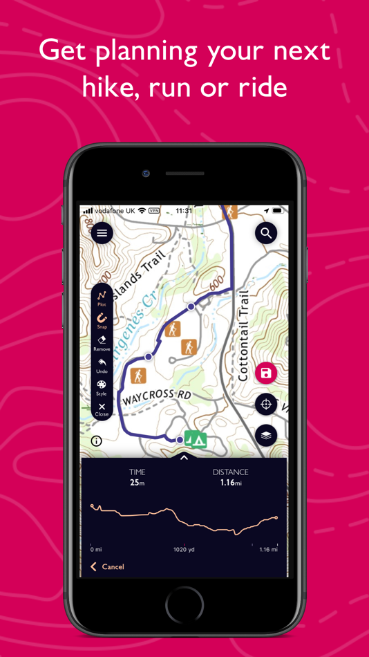
EXPLORE & PLAN HIKES, RUNS OR RIDES
Whether you are planning a walk, hike, run or ride; OS Maps lets you create outdoor adventures with trusted mapping & navigation tools from the experts at Ordnance Survey, Britain’s national mapping service.
DISCOVER THOUSANDS OF READY-MADE ROUTES
Get outside with curated routes from outdoor experts & organisations such as Trail, Country Walking, Mountain Bike UK, BBC Countryfile & more.
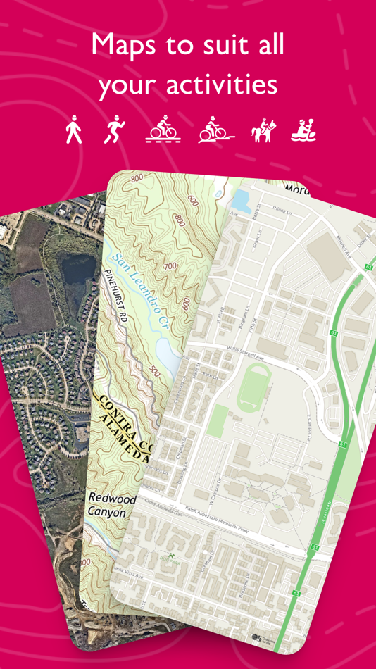
ICONIC OS MAPPING
Subscribe to unlock the detail & accuracy of OS leisure maps including OS Explorer 1:25,000 & OS Landranger 1:50,000 & now with global mapping & topographic mapping for USA, Australia & New Zealand to keep you exploring all over the world.
CREATE YOUR OWN ADVENTURES
Best in class route planning & navigation tools mean you can get off the beaten track & explore with more freedom. Plan routes with quick & easy snap-to-path route plotting, then save & share with your friends to plan that next epic day in the outdoors.
NO SIGNAL? NO PROBLEM
Download maps & routes to your phone to view offline, so they’re ready, whenever & wherever you need them. View any part of GB even without signal & export to your GPS device.
UNLIMITED PRINTING
Print copies of all your routes & maps to take with you, so you always have a backup to hand.
USE ON EVERY DEVICE
Sync your activities between across devices, on desktop, mobile & Apple Watch. On desktop, premium users can use our 3D Aerial Layer & route fly-throughs to see the landscape, terrain & explore in stunning 3D.
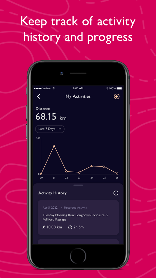
TRACK & RECORD ACTIVITIES
Use the activity recording feature to keep a log of your activity history. Follow along, save your activity, review it & turn it into a new route to share & follow again later.
RECOMMENDED BY THE EXPERTS
Ordnance Survey is proud to partner with Mountain Rescue England & Wales, with OS Maps as their recommended app to help you keep on track, & keep safe when heading outside.
TABLETOP 3D
Preview a route before you tackle it, ensure it’s suitable for your level of fitness & avoid any surprises. Our 3D model feature lets you check out your routes from the comfort of your home.
SUBSCRIPTION INFORMATION
OS Maps premium is available through a 1 month or 1 year subscription. Prices are posted in GBP but may vary by country or when converted to local currency. Subscriptions will auto-renew. Payment will be charged to iTunes Account at confirmation of purchase. The subscription automatically renews unless auto-renew is turned off at least 24-hours before the end of the current period. Your account will be charged for renewal within 24-hours prior to the end of the current period, & identify the cost of the renewal. Subscriptions may be managed by the user & auto-renewal may be turned off by going to the user's Account Settings after purchase.
Terms & Conditions at os.uk/termsosmaps
USEFUL INFORMATION
Battery life while using the app can be extended downloading maps offline prior to use, operating in Flight Mode (the GPS will still work) & turning off the screen when not in use. We release updates to all of our apps on an ongoing basis to improve stability & add extra features. Topographic mapping is available for UK (including Northern Ireland), USA, Australia & New Zealand. Your feedback & comments about this app are important to us. Leave a review or use os.uk/contact to get in touch.
*This feature uses Apple's ARKit which requires an iPhone 6s, iPhone SE, iPad 2017, iPad Pro or any later device.
ภาพหน้าจอ


มีอะไรใหม่
- เวอร์ชัน: 5.0.6
- อัปเดต:
- This latest release addresses minor bugs such as improvements to exporting a route on iPad.
ราคา
-
*การซื้อภายในแอพ - วันนี้: ฟรี
- ต่ำสุด: ฟรี
- มากที่สุด: ฟรี
ติดตามราคา
ผู้พัฒนา
- Ordnance Survey
- แพลตฟอร์ม: iOS แอป (2)
- รายการ: 0 + 0
- แต้มแล: 0 + 344 ¡
- การจัดอันดับ: 0
- ความเห็น: 0
- ลดราคา: 0
- วิดีโอ: 0
- RSS: ติดตาม
แต้มแล
ไม่พบ ☹️
การจัดอันดับ
ไม่พบ ☹️
รายการ
ไม่พบ ☹️
ความเห็น
แสดงรีวิวเป็นคนแรกเลย!
ข้อมูลเพิ่มเติม
- หมวดหมู่:
iOS แอป›การนำทาง - ระบบปฏิบัติการ:
Apple Watch,iPad,iPhone,iOS 15.0 และสูงกว่า - ขนาด:
106 Mb - ภาษาที่สนับสนุน:
English - การจัดประเภทเนื้อหา:
4+ - App Store คะแนนโดย:
4.7(229) - อัปเดต:
- วันที่วางจำหน่าย:
รายชื่อติดต่อ
- เว็บไซท์:
 http://osmaps.co.uk
คุณอาจชอบ
-
- Trails Offroad
- iOS แอป: การนำทาง โดย: TRAILS OFFROAD LLC
- * ฟรี
- รายการ: 0 + 0 การจัดอันดับ: 0 ความเห็น: 0
- แต้มแล: 0 + 138 เวอร์ชัน: 2.7.1 Discover the ultimate off-road trail experience with Trails Offroad, your essential guide to exploring the great outdoors. Whether you're into 4x4, Jeep, Bronco, ATV, or Overlanding ...
-
- OutDoors GB - Offline OS Maps
- iOS แอป: การนำทาง โดย: RoadTour LLC
- $1.99
- รายการ: 0 + 0 การจัดอันดับ: 0 ความเห็น: 0
- แต้มแล: 0 + 14 เวอร์ชัน: 6.5.7 Includes a free download of all 15 GB National Parks, normally £9.99 (Ordnance Survey 1:50k). Extremely easy to use and looks great. [Trek & Mountain Magazine] The best way to access ...
-
- Bikemap: Bike Trails & Tracker
- iOS แอป: การนำทาง โดย: Bikemap GmbH
- * ฟรี
- รายการ: 0 + 0 การจัดอันดับ: 0 ความเห็น: 0
- แต้มแล: 0 + 8,321 เวอร์ชัน: 29.9.0 Do you love to discover, navigate, and track new cycling routes? Then you'll love Bikemap. It doesn't matter if bicycling for you means a leisurely ride with your city bike or e-bike, ...
-
- OS Locate
- iOS แอป: การนำทาง โดย: Ordnance Survey
- ฟรี
- รายการ: 0 + 0 การจัดอันดับ: 0 ความเห็น: 0
- แต้มแล: 0 + 115 เวอร์ชัน: 1.6.2 Make the most of your adventures in the great outdoors with OS Locate. Used alongside your Ordnance Survey map, OS Locate is a fast and highly accurate means of pinpointing your exact ...
-
- HiiKER: The Hiking Maps App
- iOS แอป: การนำทาง โดย: Waymarked Trails LTD
- * ฟรี
- รายการ: 0 + 0 การจัดอันดับ: 0 ความเห็น: 0
- แต้มแล: 0 + 380 เวอร์ชัน: 5.007 HiiKER is the hiking app that is dedicated to building tools specifically for the hiking community. More than just a map and a compass, the app enables you to hike in the great ...
-
- Goose Maps for Watch
- iOS แอป: การนำทาง โดย: GOOSE MAPS LTD
- ฟรี
- รายการ: 0 + 0 การจัดอันดับ: 0 ความเห็น: 0
- แต้มแล: 0 + 181 เวอร์ชัน: 1.3 Features - Navigate easily everywhere Our pedestrian and bike navigation perfectly work even if your iPhone stayed at home. - Search objects you need Our search helps you to find ...
-
- Bike Citizens Cycling App GPS
- iOS แอป: การนำทาง โดย: Smettly GmbH
- ฟรี
- รายการ: 0 + 0 การจัดอันดับ: 0 ความเห็น: 0
- แต้มแล: 0 + 137 เวอร์ชัน: 8.4.7 Your cycling app with route planner, navigation, tracking and more for cycling in and around the city. Download and start right away: Multi-stop route planning, navigation and many ...
-
- Bike Tracks
- iOS แอป: การนำทาง โดย: Core Coders Ltd
- $1.99
- รายการ: 0 + 0 การจัดอันดับ: 0 ความเห็น: 0
- แต้มแล: 0 + 32 เวอร์ชัน: 1.7.0 Record all your cycling adventures and have them available at any time. Bike Tracks contains following exciting features. - Offline Maps. - Open Cycle and Open Street maps - Add Routes
-
- Maps 3D PRO - Hike & Bike
- iOS แอป: การนำทาง โดย: movingworld GmbH
- * $3.99
- รายการ: 1 + 4 การจัดอันดับ: 0 ความเห็น: 0
- แต้มแล: 0 + 194 เวอร์ชัน: 6.8 Enjoy exploring the great outdoors? If you re a fan of biking, hiking and running then Maps 3D is the ideal app designed for planning your outdoor adventures. Whereas other mapping ...
-
- Bike Itaú
- iOS แอป: การนำทาง โดย: tembici
- ฟรี
- รายการ: 0 + 0 การจัดอันดับ: 0 ความเห็น: 0
- แต้มแล: 0 + 425 เวอร์ชัน: 9.11.0 See where the bikes and docking points are available at stations in your city. Purchase subscriptions and rent bikes directly from the app! You can also use the Bike Itaú App to: ...
-
- Apple Maps
- iOS แอป: การนำทาง โดย: Apple
- ฟรี
- รายการ: 3 + 1 การจัดอันดับ: 4 (1) ความเห็น: 0
- แต้มแล: 1 + 23,006 เวอร์ชัน: 1.5 Maps Apple Maps is the best way to navigate and explore the world - all with your privacy protected. What s New: Multi-stop routing lets you add multiple stops along your driving route
-
- Mapy.cz: maps & navigation
- iOS แอป: การนำทาง โดย: Seznam.cz a.s.
- ฟรี
- รายการ: 0 + 0 การจัดอันดับ: 0 ความเห็น: 0
- แต้มแล: 2 + 631 เวอร์ชัน: 6.40.1 PLAN YOUR ROUTE - hiking and cycling trails - cross-country skiing and ski-alpine trails - unique travel tips feature plans a trip through the most interesting places in the area - ...
-
- onX Backcountry Trail Maps GPS
- iOS แอป: การนำทาง โดย: onXmaps, Inc.
- * ฟรี
- รายการ: 0 + 0 การจัดอันดับ: 0 ความเห็น: 0
- แต้มแล: 1 + 1,923 เวอร์ชัน: 24.17.0 Meet the ultimate GPS map app for your outdoor pursuits. onX Backcountry lets you easily find and navigate the trails you're looking for whether you re seeking out new backcountry ski ...
-
- Topo Maps Canada
- iOS แอป: การนำทาง โดย: David Crawshay
- ฟรี
- รายการ: 0 + 0 การจัดอันดับ: 0 ความเห็น: 0
- แต้มแล: 0 + 8 เวอร์ชัน: 6.4.1 Download and view topographic maps covering Canada. Topographic maps are useful for recreational activities such as hiking, canoeing, camping, fishing, mountain biking, geocaching, and