| ผู้พัฒนา: | Pocket Mariner Ltd. (12) | ||
| ราคา: | * $19.99 | ||
| การจัดอันดับ: | 0 | ||
| ความเห็น: | 0 เขียนความเห็น | ||
| รายการ: | 0 + 0 | ||
| แต้มแล: | 0 + 94 (4.3) ¡ | ||
| App Store | |||
คำอธิบาย
")
- Includes all US Coastal, Inland and Great Lakes Digital Vector Charts
- Buoys, lights etc. are tappable with bearing and distance
- Free Apple Watch app
- Seamless panning and zooming across charts
- Unique live Augmented Reality camera view
- Route Planning and tracking with Waypoints, ETA, XTE, etc.
- Offline charts
- Route export and import
- Live AIS Ship targets (requires Boat Beacon)
- ActiveCaptain Marinas, Anchorage, Hazards and reviews
- US NOAA Raster charts available via IAP
- Canadian charts via IAP
- British Virgin Islands & Bermuda charts via IAP
- External NMEA over Wifi
SeaNav is a Universal app, which works on iPad, iPhone and iPod.
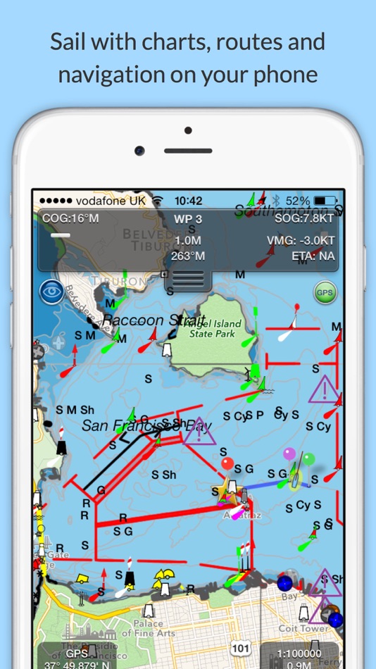
SeaNav uses Digital Vector charts providing a wealth of benefits and advantages. Buoys, Lights, Bridges, Depth Contours, Depth Soundings, Rocks, Anchorage areas, NOAA Weather Buoys etc. are all selectable and have real time distance, bearing and detail information. Turn off layers to de-clutter the display and only show what is important at the time. Tides, moon and sun times and weather are also all available at your fingertips.
SeaNav’s unique AR view mode allows you to view buoys, lights, ships, waypoints and track overlaid on your iPhone or iPad live camera view. With "AR LockOn" you can select a target on the chart and then be guided to it in the AR camera view.
SeaNav lets you measure distances and bearings and record waypoints on routes. When at sea, the app’s Sailing HUD shows your position, Course over ground (COG), Speed over ground (SOG), Vector Made Good (VMG), Estimated Time of Arrival (ETA), Distance and bearing to next Waypoint. Waypoint reached alerts, auto-routing to the next waypoint and collision alerts.
SeaNav has free Apple Watch and Pebble Smartwatch apps available.
Lowrance, Simrad and B&G GoFree support included.
Your purchase of SeaNav includes 12 months of free updates to the included US chart set. Further chart updates are then available via an in-app purchase. Charts for other regions including Canada may also be added to your product via optional in-app purchase.
Our in-app purchases are 1 year subscriptions, which automatically renew at the end of the subscription period unless auto-renew is turned off at least 24-hours before the end of the current period. Payment will be charged to your iTunes Account at confirmation of purchase, and will be charged for renewal within 24-hours prior to the end of the current period. Pricing for our 1 year US Charts update subscription is US$9.99.
Subscriptions may be managed by the iTunes account holder and auto-renewal may be turned off by going to Account Settings after purchase.
No cancellation of the current subscription is allowed during active subscription period.
Our Privacy Policy may be accessed via http://seanav.net/privacy.php
Requires iPhone or iPad. GPS only required for real time route navigation. Optional Real time AIS, Tides and Weather information require an active internet connection.
iPhone devices and iPads with a cellular modem already have a built-in GPS, even if they do not have an active service plan.
If you have a WiFi-only iPad or iPod you will need an external GPS receiver or GPS feed to enable navigation.
Please note that continued use of GPS running in the background can dramatically decrease battery life.
NOT FOR NAVIGATION
This program is distributed in the hope that it will be useful. SeaNav should only be used for basic navigation reference and should not be solely relied upon to determine precise locations, proximity, distance, or direction.
Terms of Use: http://seanav.net/termsofuse.php
Privacy Policy: http://seanav.net/privacy.php
Support: help@pocketmariner.com
Third Party Licenses and Notices
NOTICE: US Marine Charts are derived from official NOAA Electronic Navigational Charts.
ภาพหน้าจอ


มีอะไรใหม่
- เวอร์ชัน: 5.4.20
- อัปเดต:
- Improved ruler UI :- endpoints now easier to select & drag and magnifier view added to show what's under your finger for more exact placement.
Improvements to offline handling.
Battery level indicator for iPhone landscape mode
Time sensitive alerts for anchor watch and CPA.
ราคา
-
* การซื้อภายในแอพ - วันนี้: $19.99
- ต่ำสุด: $19.99
- มากที่สุด: $19.99
ติดตามราคา
ผู้พัฒนา
แต้มแล
0 ☹️
การจัดอันดับ
0 ☹️
รายการ
0 ☹️
ความเห็น
แสดงรีวิวเป็นคนแรกเลย 🌟
ข้อมูลเพิ่มเติม
- เวอร์ชัน: 5.4.20
- ID: com.electricpocket.seanav.us
- หมวดหมู่:
iOS แอป›การนำทาง - ระบบปฏิบัติการ:
Apple Watch,iPad,iPhone,iOS 15.6 และสูงกว่า - ขนาด:
69 Mb - ภาษาที่สนับสนุน:
Danish,English,French,German,Italian,Spanish,Swedish - การจัดประเภทเนื้อหา:
4+ - App Store คะแนนโดย:
4.3(94) - อัปเดต:
- วันที่วางจำหน่าย:
รายชื่อติดต่อ
- เว็บไซท์:
 http://pocketmariner.com
คุณอาจชอบ
-
- SEA.AI
- iOS แอป: การนำทาง โดย: SEA.AI SAS
- ฟรี
- รายการ: 0 + 0 การจัดอันดับ: 0 ความเห็น: 0
- แต้มแล: 0 + 0 เวอร์ชัน: 2.3 Increase your vigilance and improve your safety at sea with the SEA.AI application, the user interface of the first marine optical system based on artificial vision. SEA.AI increases ... ⥯
-
- Nav Tools - Flight and Sail
- iOS แอป: การนำทาง โดย: NAVSTEP LLC
- $3.99
- รายการ: 0 + 0 การจัดอันดับ: 0 ความเห็น: 0
- แต้มแล: 7 + 0 เวอร์ชัน: 1.1.0 The Nav Tools app is a mobile navigation toolbox for air and watercrafts which is always at hand on your iPhone. It uses full power of device s internal sensors data (gyroscope, ... ⥯
-
- Nav Camera
- iOS แอป: การนำทาง โดย: Craig Hunter
- $3.99
- รายการ: 0 + 0 การจัดอันดับ: 0 ความเห็น: 0
- แต้มแล: 0 + 34 (4.0) เวอร์ชัน: 1.2.3 Nav Camera uses the proven navigation, augmented reality, and image processing engines from the well known Theodolite app to create a new app that focuses on photogaphy and video ... ⥯
-
- US Metro - Washington, NYC, LA
- iOS แอป: การนำทาง โดย: AR Code Pte. Ltd.
- * ฟรี
- รายการ: 0 + 0 การจัดอันดับ: 0 ความเห็น: 0
- แต้มแล: 0 + 74 (4.7) เวอร์ชัน: 7.2 US subway maps, offline use. Atlanta, Baltimore, Boston, Chicago, Cleveland, Los Angeles, Miami, New York City, Philadelphia, San Francisco & Washington metro maps. Maps features: - ... ⥯
-
- Nav Trainer Pro
- iOS แอป: การนำทาง โดย: FLEMINGER MEDIA LLC
- $8.99
- รายการ: 0 + 0 การจัดอันดับ: 0 ความเห็น: 0
- แต้มแล: 0 + 37 (3.9) เวอร์ชัน: 3.5.0 Selected by AOPA.org readers as number one of five aviation apps you can't live without! * Reached No. 4 in the Navigation category of the U.S. app store for iPad! Make IFR flight ... ⥯
-
- US Traveler
- iOS แอป: การนำทาง โดย: John Stump
- ฟรี
- รายการ: 0 + 0 การจัดอันดับ: 0 ความเห็น: 0
- แต้มแล: 0 + 129 (4.7) เวอร์ชัน: 1.8 Know before you go. Whether you're a commuter or a recreational traveler, you need information about the road ahead. With this app, you can see road conditions, view traffic cameras, ... ⥯
-
- Nav GC
- iOS แอป: การนำทาง โดย: domesticusdevelop
- $0.99
- รายการ: 0 + 0 การจัดอันดับ: 0 ความเห็น: 0
- แต้มแล: 0 + 1 (1.0) เวอร์ชัน: 2.3 Great circle navigation. -Calculate distance and heading along the great circle between two positions. -Put in speed and get the time to travel. -Use GPS for start position or own ... ⥯
-
- Nav Diag
- iOS แอป: การนำทาง โดย: Alastair Bor
- ฟรี
- รายการ: 0 + 0 การจัดอันดับ: 0 ความเห็น: 0
- แต้มแล: 0 + 0 เวอร์ชัน: 1.0 NavDiags is a comprehensive location and navigation diagnostics application for iOS developers, location-based service professionals, and tech enthusiasts needing detailed insights ... ⥯
-
- Sea Pro Connect
- iOS แอป: การนำทาง โดย: John Crawford
- ฟรี
- รายการ: 0 + 0 การจัดอันดับ: 0 ความเห็น: 0
- แต้มแล: 0 + 0 เวอร์ชัน: 2.0.5 SeaPro GPS tracker allows clients to remotely monitor vital information on their boat and GPS track both in real time and also with historical playback ⥯
-
- Applegreen Electric US
- iOS แอป: การนำทาง โดย: Applegreen Electric US Inc
- ฟรี
- รายการ: 0 + 0 การจัดอันดับ: 0 ความเห็น: 0
- แต้มแล: 1 + 35 (1.8) เวอร์ชัน: 8.1.3 Applegreen Electric EV Charging App The Fast, Convenient Charging Solution for Electric Vehicles in New York, New Jersey & Connecticut. The Applegreen Electric app is the ideal ... ⥯
-
- RT-Nav
- iOS แอป: การนำทาง โดย: Hilton's Fishing Charts, L.L.C.
- ฟรี
- รายการ: 0 + 0 การจัดอันดับ: 0 ความเห็น: 0
- แต้มแล: 0 + 8 (3.0) เวอร์ชัน: 1.178 Hilton's Realtime-Navigator Mobile Navigation Application. Navigate on almost real-time imageries such as sea surface temperatures, chlorophyll, surface currents, altimetry, and ... ⥯
-
- FlyBy Nav
- iOS แอป: การนำทาง โดย: Lonnie Ganz
- $0.99
- รายการ: 0 + 0 การจัดอันดับ: 0 ความเห็น: 0
- แต้มแล: 0 + 2 (5.0) เวอร์ชัน: 1.63 Flight planning is as easy as tapping in your point of departure, arrival and winds! In one screen, FlyBy Nav displays track, heading, distance, ground speed, time enroute, ETA, and ... ⥯
-
- NavLink US
- iOS แอป: การนำทาง โดย: DigitalYacht Ltd.
- * $30.99
- รายการ: 0 + 0 การจัดอันดับ: 0 ความเห็น: 0
- แต้มแล: 0 + 1 (5.0) เวอร์ชัน: 5.4.11 Marine Navigation App that turns your Apple Device in to a full function chart plotter. Features include: · Realtime GPS position plotted on Marine charts derived from NOAA data ... ⥯
-
- Open Sea OpenSeaMap Browser
- iOS แอป: การนำทาง โดย: Mobile Geographics
- ฟรี
- รายการ: 0 + 0 การจัดอันดับ: 0 ความเห็น: 0
- แต้มแล: 0 + 5 (3.2) เวอร์ชัน: 1.1 Open Sea is a browser for the maps produced by the OpenSeaMap project. OpenSeaMap is a subproject of OpenStreetMap, and generates freely usable nautical chart data and map image ... ⥯