| Vývojář: | JOMO Solutions Ltd (17) | ||
| Cena: | $1.99 | ||
| Hodnocení: | 0 | ||
| Recenze: | 0 Napsat recenzi | ||
| Seznamy: | 1 + 1 | ||
| Body: | 0 + 1 (5.0) ¡ | ||
| App Store | |||
Popis
")
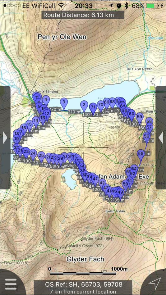
Beautifully detailed maps supplied by Ordnance Survey.
Snowdonia Maps provides a useful offline (no mobile signal required) mapping reference and navigation aid whilst travelling throughout Snowdonia by footpath, road, rail, canal, lake and river. Intuitive route and waypoint management features are implemented enabling creation, modification, deletion, import and export of routes. A powerful offline search facility can locate places, roads, post codes and hills within the region. Worldwide online Apple Maps (Standard, Satellite and Hybrid) with map features that users are used to are available on both offline and online maps as well as providing 3D buildings on Apple maps (where available).
Maps
7 different levels of offline 2014/2015 Ordnance Survey map detail from national overview to street view within the region. (No data connection required)
Progressively more detailed maps are automatically loaded as the map view is zoomed. The OS recommended viewing scales for the more detailed maps are approximately as follows:
1:1000,000 (The whole of GB is covered at this map scale)
1:250,000
1:50,000
1:25,000
1:10,000 ( (Roads/streets are labelled by name))
The map region of the more detailed maps covers a rectangular region around the national park boundary (ref. http://jomosolutions.com/Maps)
- Contours with height information and annotated height points
- Extensive footpaths from ©OpenStreetMap contributors
- National Park boundary demarkation
App
- Route/Waypoint management.
- Offline search functionality with searchable locations (places, roads, post codes and hills). (For the place search a location's latitude and longitude is accurate to 0.1 of a minute of the centre point of the 1x1 km National Grid square in which the name falls)
- Detailed hill information, including height, OS Grid Ref, latitude and longitude, region, parent, classification, drop and hill specific links to Streetmap, Geograph and Hill Bagging web sites
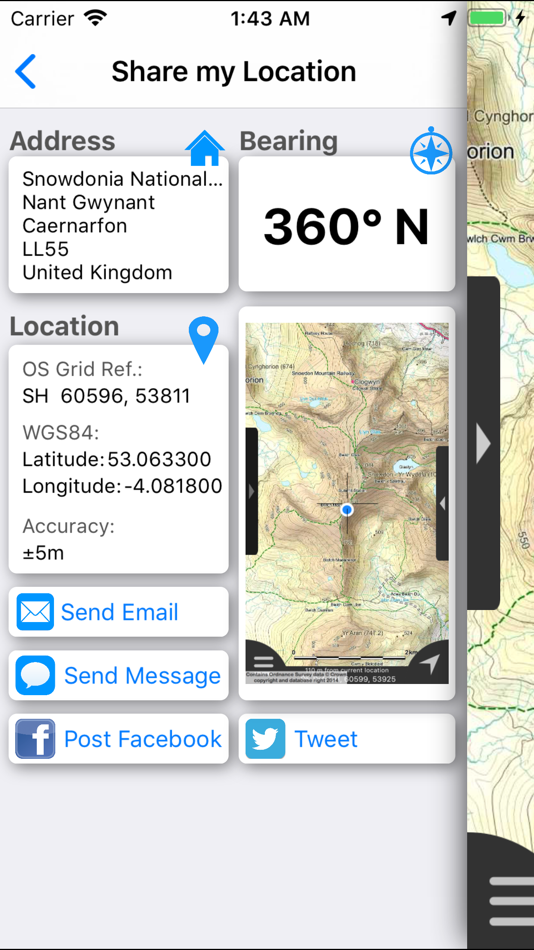
- Display of current GPS position as OS Grid Reference or WGS84 latitude and longitude
- "Share My Location" allowing users to share an image of their current location and location references. Buttons are provided to share location information by Facebook, Twitter, iMessage/SMS and e-mail
- Online access to worldwide Apple Standard, Satellite and Hybrid maps
- Apple 3D Buildings are displayed on Apple Standard maps
- Apple maps contain Points of Interest
- User location can be tracked with or without heading on all online and offline maps (GPS capable devices only)
- Display of scale bar in either metric or imperial units
- Display of current speed
- Zoom, pan, rotation of all maps
- Pitch of Apple Standard and Ordnance Survey maps
- Selection of current location annotation for display of speed and location data
- User setting for speed display in Miles per Hour (mph) or Kilometres per Hour (kph)
- Selection of search result pin annotations to display location information
- Collective deletion of search result annotation pins
- A user guide is provided within
The OS search data was published by Ordnance Survey in 2014.
Extracts from "The Database of British and Irish Hills" v14 published 22/04/2014 (ref. http://www.hills-database.co.uk/index.html )
No warranty
The data is supplied by Apple, Ordnance Survey, contributors to OpenStreetMap and Database of British and Irish Hills.
The Information is licensed 'as is' and the Information Provider and/or Licensor excludes all representations, warranties, obligations and liabilities in relation to the Information to the maximum extent permitted by law.
The Information Provider and/or Licensor are not liable for any errors or omissions in the Information and shall not be liable for any loss, injury or damage of any kind caused by its use.
This app is not a substitute for a paper map and compass.
Snímky obrazovky


Novinky
- Verze: 2.1.1
- Aktualizováno:
- Fixed intermittent failures within the search functionality.
If you like the app please leave an app review.
Cena
- Dnes: $1.99
- Minimální: $1.99
- Maximální: $1.99
Sledovat ceny
Vývojář
- JOMO Solutions Ltd
- Platformy: iOS Aplikace (17)
- Seznamy: 1 + 1
- Body: 0 + 16 ¡
- Hodnocení: 0
- Recenze: 0
- Slevy: 0
- Videa: 0
- RSS: Odebírat
Body
0 ☹️
Hodnocení
0 ☹️
Seznamy

Recenze
Buďte první, kdo bude hodnotit 🌟
Další informace
- Verze: 2.1.1
- Kategorie:
iOS Aplikace›Navigace - OS:
Apple Watch,iPad,iPhone,iOS 8.0 a vyšší - Velikost:
721 Mb - Podporovaný jazyk:
English - Hodnocení obsahu:
4+ - App Store Hodnocení:
5.0(1) - Aktualizováno:
- Datum vydání:
Kontakty
- 🌟 Sdílet
- App Store
Mohlo by se Vám také líbit
-
- Organic Maps: Offline Map
- iOS Aplikace: Navigace Podle: Organic Maps
- Zdarma
- Seznamy: 1 + 1 Hodnocení: 0 Recenze: 0
- Body: 3 + 916 (4.8) Verze: 2025.11.26 Organic Maps is a fast, detailed offline map and GPS navigation app for travel, hikes, and rides. Plan, import, and record routes, and enjoy smooth guidance without draining your ... ⥯
-
- Avenza Maps: Offline Mapping
- iOS Aplikace: Navigace Podle: Avenza Systems Inc.
- Zdarma
- Seznamy: 0 + 1 Hodnocení: 0 Recenze: 0
- Body: 0 + 122,784 (4.8) Verze: 262 Avenza Maps, #1 app for hiking, biking and all trails. Featuring maps from National Geographic, national parks and more! On your next adventure, stay on track with GPS using offline ... ⥯
-
- Offline GPS Converter
- iOS Aplikace: Navigace Podle: Artur Pahasian
- Zdarma
- Seznamy: 0 + 0 Hodnocení: 0 Recenze: 0
- Body: 0 + 1 (3.0) Verze: 1.0 Offline GPS Converter helps you instantly convert geographic coordinates no internet needed. Whether you're a field worker, radio operator, or outdoor enthusiast, this app delivers ... ⥯
-
- Offline gps maps: Mapy.com
- iOS Aplikace: Navigace Podle: Seznam.cz a.s.
- Zdarma
- Seznamy: 0 + 0 Hodnocení: 0 Recenze: 0
- Body: 4 + 1,150 (4.8) Verze: 6.61.0 PLAN YOUR ROUTE - hiking and cycling trails - cross-country skiing and ski-alpine trails - unique travel tips feature plans a trip through the most interesting places in the area - ... ⥯
-
- maps.earth
- iOS Aplikace: Navigace Podle: Michael Kirk
- Zdarma
- Seznamy: 0 + 0 Hodnocení: 0 Recenze: 0
- Body: 0 + 4 (3.5) Verze: 1.13 Explore the world and get low stress directions powered by OpenStreetMap. maps.earth is built on open source. We never show you ads or sell your data. We just want a nice map. ⥯
-
- Maps My Location
- iOS Aplikace: Navigace Podle: Rohit Bhayani
- Zdarma
- Seznamy: 0 + 0 Hodnocení: 0 Recenze: 0
- Body: 0 + 1 (1.0) Verze: 1.0 A Map My Location app for iOS is a software application designed to assist You in navigating from one location to another using the Global Positioning System (GPS) technology. Key ... ⥯
-
- Offline Maps: GPS Tracker GPX
- iOS Aplikace: Navigace Podle: SERGEI BEZDENEZHNYKH
- $7.99
- Seznamy: 2 + 1 Hodnocení: 0 Recenze: 0
- Body: 23 + 44 (4.7) Verze: 3.3.9 Create, import, export tracks with waypoints. Supports offline maps, no time limits, no ads, no in-app purchases. The main functions of the application: - loading and unlimited storage ⥯
-
- Maps 3D PRO - Hike & Bike
- iOS Aplikace: Navigace Podle: movingworld GmbH
- $3.99
- Seznamy: 1 + 4 Hodnocení: 0 Recenze: 0
- Body: 0 + 202 (4.4) Verze: 6.8 Enjoy exploring the great outdoors? If you re a fan of biking, hiking and running then Maps 3D is the ideal app designed for planning your outdoor adventures. Whereas other mapping ... ⥯
-
- Maps Anywhere: Offline GPS
- iOS Aplikace: Navigace Podle: Ali Mert TUFEKCI
- Zdarma
- Seznamy: 0 + 0 Hodnocení: 0 Recenze: 0
- Body: 5 + 2 (5.0) Verze: 1.0.0.8 SecureTrek Maps Anywhere - Stay Oriented in the Wild Every year, thousands of people get lost while trekking or exploring the outdoors due to poor visibility, disorientation, or losing ⥯
-
- Maps TV
- iOS Aplikace: Navigace Podle: Anass Damri
- $0.99
- Seznamy: 0 + 0 Hodnocení: 0 Recenze: 0
- Body: 0 + 0 Verze: 1.0 Transform your TV into a powerful mapping experience with Maps TV - the ultimate navigation app designed specifically for the big screen. KEY FEATURES: Full-Screen Map Experience: ... ⥯
-
- Offline Map Navigation
- iOS Aplikace: Navigace Podle: VirtualMaze
- Zdarma
- Seznamy: 0 + 0 Hodnocení: 0 Recenze: 0
- Body: 0 + 307 (4.3) Verze: 6.1.8 Search, Get Directions & Navigate anywhere even without internet connection Turn-by-turn route instructions & real-time navigation Find directions for car, motorbike, bicycle or walk ... ⥯
-
- Goat Maps
- iOS Aplikace: Navigace Podle: Goat Maps, inc.
- Zdarma
- Seznamy: 0 + 0 Hodnocení: 0 Recenze: 0
- Body: 0 + 47 (4.7) Verze: 2025.11 Goat Maps is the next-generation navigation app designed for outdoor adventures. Built from the ground up in 2024, Goat Maps offers unmatched reliability and ease of use, perfect for ... ⥯
-
- Offline Maps Nav by Karta GPS
- iOS Aplikace: Navigace Podle: Karta
- * Zdarma
- Seznamy: 0 + 0 Hodnocení: 0 Recenze: 0
- Body: 0 + 4 (3.3) Verze: 2.51.03 Navigate in Germany and download any map from all over the world! This special German version offers free traffic and Speed Radars information with lifetime updates. All maps are free ... ⥯
-
- Offline Maps-Global Navigation
- iOS Aplikace: Navigace Podle: 洪涛 胡
- Zdarma
- Seznamy: 0 + 0 Hodnocení: 0 Recenze: 0
- Body: 1 + 0 Verze: 1.3 Powerful offline map navigation with 3 map modes and real-time positioning. Download global offline maps with smart management for accurate guidance without internet. ⥯