| Nhà phát triển: | Tech Maven GeoSpatial LLC (10) | ||
| Giá bán: | * Miễn phí | ||
| Xếp hạng: | 0 | ||
| Đánh giá: | 0 Viết đánh giá | ||
| Danh sách: | 0 + 0 | ||
| Điểm: | 1 + 0 ¡ | ||
| Điểm +1 | |||
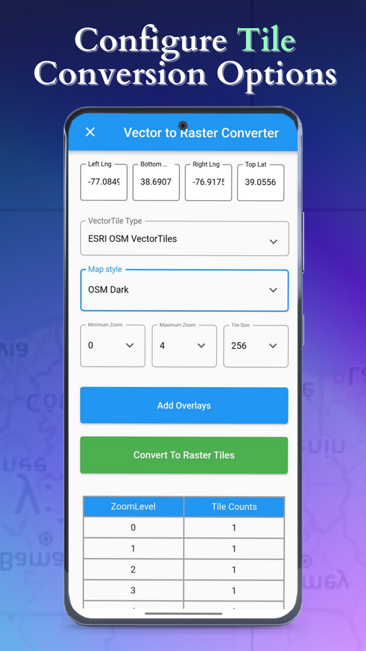
Mô tả
")
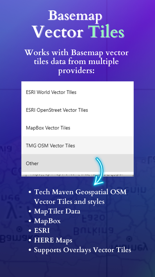
- Tech Maven Geospatial’s OSM Vector Tiles and styles (3D, 3D with Satellite, OSM Bright, Basic, fiord color, osm liberty, positron, toner, dark matter, topo-terrain, opacity styles, ESRI satellite with OSM, HERE Maps Satellite with OSM, OpenMapTiles Satellite with OSM)
- MapTiler Data (basic, bright, outdoor, streets, toner, topo, winter, dataviz, satellite hybrid)
- MapBox (Street, outdoors, Light, Dark, Satellite, Satellite Streets, Navigation Day, Navigation Night)
- ESRI (World navigation, Navigation Dark mode, Light Gray canvas, Dark gray, World terrain, World topographic, national geographic, newspaper, nova, outdoor, ocean, enhanced contrast)
- ESRI OSM (OSM Navigation, OSM Dark, Hybrid OSM)
- Load your own URL/Stylesheet
Supports Overlays Vector Tiles
Easily share converted files and view files with file manager and viewer
Why this is valuable?
Worldwide OSM Vector Tiles is about 80gb however many mapping applications don’t support vector tiles or complex vector tiles. This allow you to pre-cache an area of interest as Raster Tiles.
Users of apps like ATAK, WINTAK, iTAK, ARTAK and MCH can now have data they can consume.
Users of Mapping Libraries like Cesium WebGL that does not support vector tiles can now support data by converting to raster tiles.
Users of On-Premises or Edge Mapping /Common Operating Picture Solutions can now have rich basemap data made available for their use.
Supports styles with multiple sources (topo/terrain style with contour lines and hillshade or satellite hybrid style or other combination of data)
The app has no free component.
It requires annual subscription giving user access to map data.
The app requires purchase to use it past trial period.
EULA: https://vector2rastertiles.techmaven.net/eula/
Ảnh chụp màn hình


Tính năng mới
- Phiên bản: 1.0
- Cập nhật:
Giá bán
-
* Trong ứng dụng mua hàng - Hôm nay: Miễn phí
- Tối thiểu: Miễn phí
- Tối đa: Miễn phí
Theo dõi giá
Nhà phát triển
- Tech Maven GeoSpatial LLC
- Nền tảng: iOS Ứng dụng (9) Windows Ứng dụng (1)
- Danh sách: 0 + 0
- Điểm: 2 + 1 ¡
- Xếp hạng: 0
- Đánh giá: 0
- Giảm giá: 0
- Video: 0
- RSS: Đăng ký
Điểm
-

- 1,256 Dzamburg Dza

Xếp hạng
Không tìm thấy ☹️
Danh sách
Không tìm thấy ☹️
Đánh giá
Hãy là người đầu tiên đánh giá 🌟
Thông tin bổ sung
- Phiên bản: 1.0
- ID: com.techmaven.vector2raster
- Danh mục:
iOS Ứng dụng›Bản đồ và dẫn đường - HĐH:
iPad,iPhone,iOS 11.0 trở lên - Kích thước:
47 Mb - Ngôn ngữ được hỗ trợ:
English - Xếp hạng nội dung:
4+ - App Store Xêp hạng:
0 - Cập nhật:
- Ngày phát hành:
Danh bạ
- Trang web:
 https://mapexplorer.techmaven.net/
Bạn cũng có thể thích
-
- RIFT Notes: Retro Style Notes
- iOS Ứng dụng: Bản đồ và dẫn đường Bởi: Primary Vector Inc.
- * Miễn phí
- Danh sách: 0 + 0 Xếp hạng: 0 Đánh giá: 0
- Điểm: 0 + 3 (5.0) Phiên bản: 1.2.2 RIFT Notes: capture thoughts instantly, just like writing a text, and organize or search instantly without the noise or clutter. Write and reflect in a simple, distraction-free space ... ⥯
-
- PlugShare
- iOS Ứng dụng: Bản đồ và dẫn đường Bởi: Recargo, Inc.
- * Miễn phí
- Danh sách: 0 + 0 Xếp hạng: 0 Đánh giá: 0
- Điểm: 0 + 123,886 (4.7) Phiên bản: 7.26.0 Download the most accurate EV and Tesla charging station map. PlugShare is the world s largest EV driver community. Drivers contribute station reviews and photos to help the EV ... ⥯
-
- Global Mapper Mobile
- iOS Ứng dụng: Bản đồ và dẫn đường Bởi: Blue Marble Geographics
- * Miễn phí
- Danh sách: 0 + 0 Xếp hạng: 0 Đánh giá: 0
- Điểm: 0 + 11 (4.0) Phiên bản: 3.0.15 Bring your GIS workflow to the field. Global Mapper Mobile® is a powerful iOS application for viewing and collecting GIS data. It utilizes the GPS capabilities of mobile devices to ... ⥯
-
- BIGEMAP
- iOS Ứng dụng: Bản đồ và dẫn đường Bởi: Chengdu Bigemap Data Processing Co. Ltd
- Miễn phí
- Danh sách: 0 + 0 Xếp hạng: 0 Đánh giá: 0
- Điểm: 0 + 0 Phiên bản: 1.0.2 Bigemap is a powerful mobile GIS data collecting & processing mobile app, it can be either used for proffesional filed work (field mapping, land surveying, Vegetation management, ... ⥯
-
- iNavX: Marine Navigation
- iOS Ứng dụng: Bản đồ và dẫn đường Bởi: NavX Studios LLC
- * Miễn phí
- Danh sách: 0 + 0 Xếp hạng: 0 Đánh giá: 0
- Điểm: 7 + 19,817 (4.8) Phiên bản: 5.6.44 Marine navigation is made easy with iNavX - the world's #1 handheld Chartplotter. Access marine charts, maps, weather, AIS and more! iNavX is the only app to give you complete ... ⥯
-
- i-Boating: Marine Charts & Gps
- iOS Ứng dụng: Bản đồ và dẫn đường Bởi: Bist LLC
- * Miễn phí
- Danh sách: 0 + 1 Xếp hạng: 0 Đánh giá: 0
- Điểm: 0 + 12,777 (4.5) Phiên bản: 154.0.0 This App offers access to Marine Charts for USA,Canada,UK/Ireland,Germany,Netherlands/Holland & Europe Rivers (Danube,Drava,Rhein etc). Coverage includes NOAA marine vector ... ⥯
-
- Map Data Generator TilePackage
- iOS Ứng dụng: Bản đồ và dẫn đường Bởi: Tech Maven GeoSpatial LLC
- Miễn phí
- Danh sách: 0 + 0 Xếp hạng: 0 Đánh giá: 0
- Điểm: 0 + 0 Phiên bản: 1.0 Provides ESRI Tile Package (VTPK and TPKX) Data products for use in ESRI ArcGIS Maps SDK (Runtime) Apps like ArcGIS Field Maps, Survey123, ArcGIS Mission Responser, ArcGIS Earth, ... ⥯
-
- ActiveCaptain®
- iOS Ứng dụng: Bản đồ và dẫn đường Bởi: Garmin
- * Miễn phí
- Danh sách: 2 + 0 Xếp hạng: 0 Đánh giá: 0
- Điểm: 11 + 3,639 (3.9) Phiên bản: 39.0 The free ActiveCaptain app creates a powerful connection between your compatible mobile device and Garmin chartplotter, charts, maps and the boating community. Whether you use your ... ⥯
-
- iSailGPS : NOAA USA RNC Charts
- iOS Ứng dụng: Bản đồ và dẫn đường Bởi: James Associates Inc.
- $7.99
- Danh sách: 0 + 0 Xếp hạng: 0 Đánh giá: 0
- Điểm: 0 + 67 (3.9) Phiên bản: 9.6.1 Unleash the navigation potential of your iPhone or iPad with SailGPS! Turn your device into a high-performance GPS receiver with USA NOAA Raster Nautical Charts, even without a cell ... ⥯
-
- SeaNav
- iOS Ứng dụng: Bản đồ và dẫn đường Bởi: Pocket Mariner Ltd.
- * Miễn phí
- Danh sách: 0 + 0 Xếp hạng: 0 Đánh giá: 0
- Điểm: 0 + 211 (4.4) Phiên bản: 5.4.18 Explore, plan and navigate your boating trips in real time and outstanding high-resolution using digital charts derived from the latest official data providing coverage across the US ... ⥯
-
- topoXpress
- iOS Ứng dụng: Bản đồ và dẫn đường Bởi: TopoLynx GIS & Mapping Ltd
- Miễn phí
- Danh sách: 0 + 0 Xếp hạng: 0 Đánh giá: 0
- Điểm: 0 + 3 (4.0) Phiên bản: 1.3.1 topoXpress provides the following features: Multiplatform design: the same software with the same rich functionality for both GIS data collectors and Surveyors on iOS & macOS. Handling ⥯
-
- SEAiq USA
- iOS Ứng dụng: Bản đồ và dẫn đường Bởi: Sakhalin
- * Miễn phí
- Danh sách: 0 + 0 Xếp hạng: 0 Đánh giá: 0
- Điểm: 0 + 478 (4.7) Phiên bản: 5.4.17 SEAiq USA is a full-featured marine navigation app. It automatically downloads all charts (both vector and raster) from NOAA and the US Army Corps of Engineers for regions of USA you ... ⥯
-
- Pocket Earth PRO
- iOS Ứng dụng: Bản đồ và dẫn đường Bởi: GeoMagik LLC
- * $5.99
- Danh sách: 5 + 4 Xếp hạng: 0 Đánh giá: 0
- Điểm: 4 + 1,699 (4.8) Phiên bản: 3.9 Detailed worldwide maps and travel guides Topographic contour maps for the outdoors Works completely offline even with GPS Great when abroad or in the wilderness, NO data roaming ... ⥯
-
- Flytomap All in One HD Charts
- iOS Ứng dụng: Bản đồ và dẫn đường Bởi: Flytomap
- * $14.99
- Danh sách: 0 + 0 Xếp hạng: 0 Đánh giá: 0
- Điểm: 2 + 4 (3.3) Phiên bản: 6.5.10 FlyToMap™ is a valid and interesting alternative, Benetti Yachts The charts downloaded are resident in the app. No internet connection required! Flytomap All In One HD works on all ... ⥯