| 開發人員: | WWF Deutschland (10) | ||
| 價錢: | 免費 | ||
| 排名: | 0 | ||
| 評測: | 0 寫評論 | ||
| 清單: | 0 + 0 | ||
| 點數: | 0 + 0 ¡ | ||
| App Store | |||
描述
")
The app is designed to help you comply with the BOATING RULES. Improved navigation on the water will reduce disturbances in the protected bays and in the breeding and resting areas of waterbirds. It is intended to help ensure that people and nature can co-exist in harmony in the species-rich coastal waters.
Interesting information about NATURE is provided for individual areas and the legal regulations are also available for anyone who wants to know more.
HOW THE APP WORKS
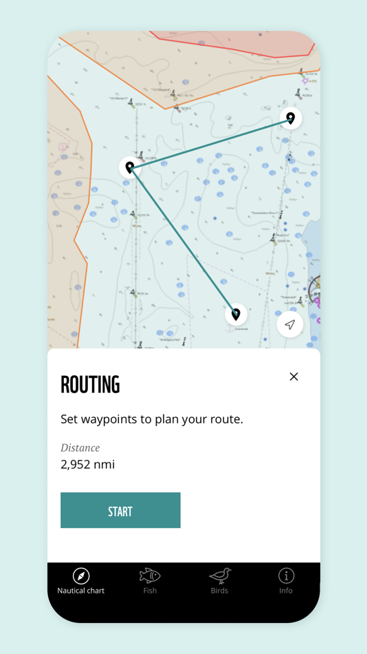
Navigate through the Wismar Bay and the Bay of Greifswald using the routing function. Waypoints make it easy for you to avoid the protected areas.
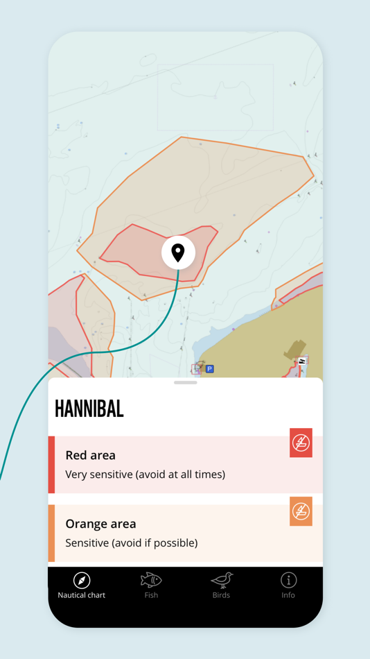
Click on the red and orange zoning or colour-coded protected areas to learn more about nature and special regulations.
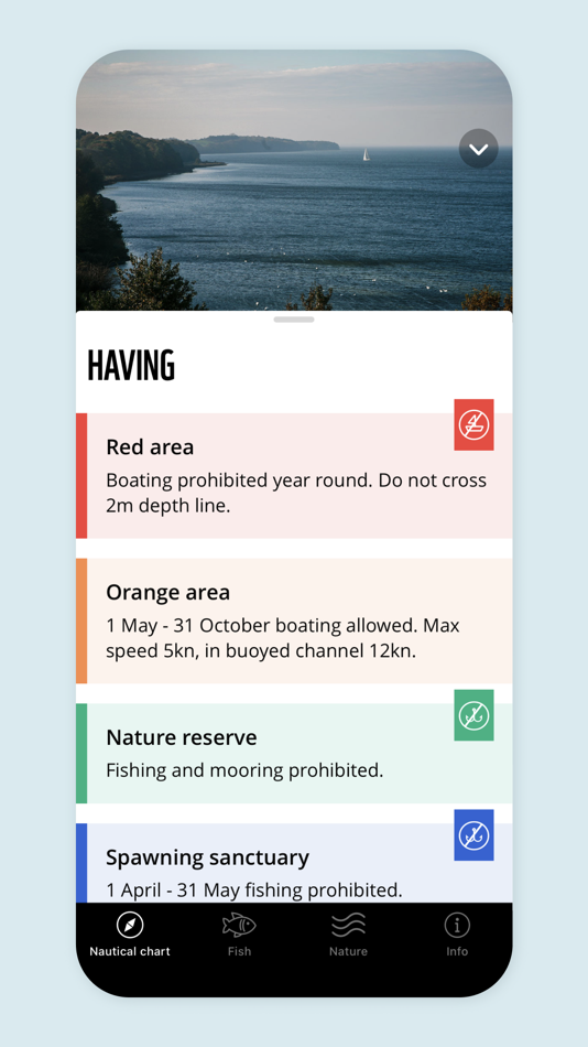
The “Nature” section contains a glossary with explanations of protected areas, regulations and institutions.
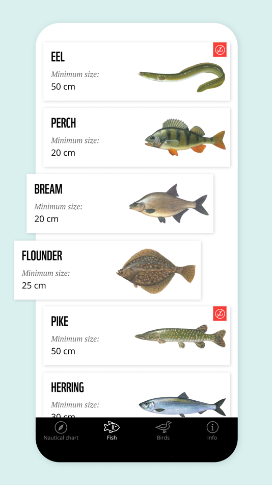
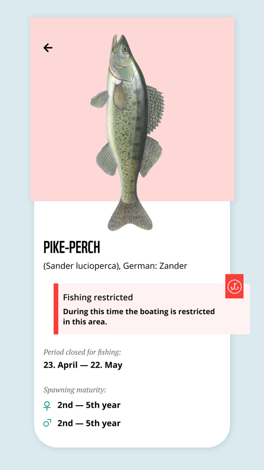
In the “Fish” section you can find useful information about fishing, including a description of individual fish, fishing seasons, minimum sizes, periods closed to fishing and the Red List status of the individual species.
The “Bird” section features common birds with photos and audio.
Detailed maps can be downloaded under “Info” and then “Nautical charts”.
FEATURES:
- Waypoints can be set with the routing function. The distance and course of the selected route are automatically displayed.
- Orange and red areas indicate when boating is permitted in the area or not.
- If the boat crosses the boundary of a restricted protected area, a message automatically appears on the map.
- Coloured areas provide information about the protected areas (including nature conservation areas and fish sanctuaries).
- Minimum sizes and seasons closed for fishing: during the season when fishing is not permitted for a species, a crossed-out fishhook appears next to the fish.
- Winter sanctuaries, fish and spawning sanctuaries are only shown on the map during the period closed for fishing.
- Use the layer icon to show and hide the areas for boating and fishing.
Have a great day out on the water! Enjoy your visit and please respect nature!
螢幕擷取畫面

新功能
- 版本: 2.1.0
- 發佈日期:
- The zones of the voluntary agreement of the Bay of Wismar have been updated and aligned to the nautical chart.
價錢
- 今天: 免費
- 最小值: 免費
- 最大值: 免費
追蹤票價
開發人員
- WWF Deutschland
- 平台: Android 應用程式 (6) iOS 應用程式 (4)
- 清單: 0 + 0
- 點數: 0 + 210 ¡
- 排名: 0
- 評測: 0
- 折扣: 0
- 影片: 0
- RSS: 訂閱
點數
0 ☹️
排名
0 ☹️
清單
0 ☹️
評測
成為第一個評論 🌟
其他資訊
- 🌟 分享
- App Store
你可能還喜歡
-
- Germany HD GPS Nautical Chart
- iOS 應用程式: 地圖與導航 由: Flytomap
- $19.99
- 清單: 0 + 0 排名: 0 評測: 0
- 點數: 0 + 0 版本: 5.6.1 Flytomap is a valid and interesting alternative, Benetti Yachts Featured in : On the Deck Germany coverage resident in the app. It works WITHOUT mobile coverage! Worldwide Marine and ... ⥯
-
- Nautical Calculator Pro
- iOS 應用程式: 地圖與導航 由: Giacomo Gabriele
- $8.99
- 清單: 0 + 0 排名: 0 評測: 0
- 點數: 0 + 3 (5.0) 版本: 12.1.0 Nautical Calculator Pro is the most complete application that solves the navigation calculations The main features are : - Calculate Route (solves 2nd navigation problem) - Calculate ... ⥯
-
- Nautical Calculator Preview
- iOS 應用程式: 地圖與導航 由: The Vu Cong
- 免費
- 清單: 0 + 0 排名: 0 評測: 0
- 點數: 0 + 1 (5.0) 版本: 7.2.9 The application to assist in solving the most important marine problems. - For Marine Navigation +Real-Time Ship Movement; +Route Plan; + Mercator Sailing. + Greate Circle Sailing. + ... ⥯
-
- Nautical Nomograph
- iOS 應用程式: 地圖與導航 由: Universal Queue LLC
- $4.99
- 清單: 0 + 0 排名: 0 評測: 0
- 點數: 0 + 4 (5.0) 版本: 1.0 Nautical Nomograph is your go-to tool for quick time-speed-distance calculations. Say goodbye to tedious math; this app turns a traditionally mundane task into an engaging experience. ... ⥯
-
- Nautical Charts & Maps
- iOS 應用程式: 地圖與導航 由: LW Brands, LLC
- $8.99
- 清單: 0 + 0 排名: 0 評測: 0
- 點數: 0 + 3,721 (4.6) 版本: 1.14 Main Features Include: + NOAA Electronic Navigational Charts (ENC) + NOAA Weather Map Overlays -- ELECTRONIC NAVIGATION CHARTS -- Electronic Navigational Charts (ENC) are vector data ... ⥯
- -67%
- iSailGPS NZ : Nautical Charts
- iOS 應用程式: 地圖與導航 由: James Associates Inc.
- ▼ $0.99
$2.99-67% - 清單: 0 + 0 排名: 0 評測: 0
- 點數: 1 + 0 版本: 9.6.6 Unleash the navigation potential of your iPhone or iPad with SailGPS NZ! Turn your device into a high-performance GPS receiver with LINZ RNC Nautical Charts, even without a cell ... ⥯
-
- EZ Nautical Almanac
- iOS 應用程式: 地圖與導航 由: EZ Celestial LLC
- $9.99
- 清單: 0 + 0 排名: 0 評測: 0
- 點數: 1 + 5 (5.0) 版本: 1.4 You need a Nautical Almanac to do celestial navigation. In today s digital age, why buy a new book every year when you can buy a digital Nautical Almanac that provides 100 years of ... ⥯
-
- Map Chart Mosaic
- iOS 應用程式: 地圖與導航 由: AppMosaic.com
- $3.99
- 清單: 0 + 0 排名: 0 評測: 0
- 點數: 0 + 2 (3.0) 版本: 1.2.6 Offline maps for iPhone, Apple Watch, Fitbit, Garmin or Amazfit smartwatch: topographic maps, satellite images, GRIB weather forecast maps and road maps with cycle and hiking trails. ... ⥯
-
- Perpetual Nautical Almanac
- iOS 應用程式: 地圖與導航 由: RPA Technologies
- $6.99
- 清單: 0 + 0 排名: 0 評測: 0
- 點數: 0 + 1 (5.0) 版本: 2.01 Using the U.S. Naval Observatory NOVAS library and solar system ephemerides from JPL, high precision positions can be calculated in real-time from 1900 to 2050. Simply select date and ... ⥯
-
- Marine Chart Symbols
- iOS 應用程式: 地圖與導航 由: Imray
- $4.99
- 清單: 0 + 0 排名: 0 評測: 0
- 點數: 0 + 3 (1.7) 版本: 2.1.2 Complete reference for symbols, abbreviations and terms used in marine charts. Useful as an aid for teaching and learning, or as reminder for experienced sailors and sea cartography ... ⥯
-
- Maptech iPlot
- iOS 應用程式: 地圖與導航 由: Nautical Solutions International, Inc.
- * $39.99
- 清單: 0 + 0 排名: 0 評測: 0
- 點數: 2 + 7 (2.1) 版本: 1.10.54 Maptech iPlot - Real Time Chart Plotting App The Maptech iPlot app is simple to use chart plotter app that utilizes many of the same routing functions that Maptech uses in their ... ⥯
-
- NV Charts GPS Navigation AIS
- iOS 應用程式: 地圖與導航 由: NV Chart Group GmbH
- * 免費
- 清單: 0 + 0 排名: 0 評測: 0
- 點數: 0 + 106 (4.4) 版本: 2.753.249 Enhance your navigation experience with a seamless navigation solution that provides up-to-date digital nautical charts, comprehensive harbour information, and a full suite of ... ⥯
-
- NaVida
- iOS 應用程式: 地圖與導航 由: Electronic Chart Centre
- * 免費
- 清單: 0 + 0 排名: 0 評測: 0
- 點數: 0 + 2 (4.0) 版本: 1.8.1 One of the top free map display apps for both mobile and tablets! NaVida is a free app ideal for anyone using maps/charts on land and sea. It contains a growing number of quality map ... ⥯
-
- The Navigator
- iOS 應用程式: 地圖與導航 由: The Nautical Institute
- 免費
- 清單: 0 + 0 排名: 0 評測: 0
- 點數: 0 + 2 (4.0) 版本: 4.0.1 -Inspiring professionalism in marine navigators -A free publication by The Nautical Institute in association with the Royal Institute of Navigation -Published three times a year -Full ... ⥯